Table of Contents
Cloud Structure In Satellite Images
Front Delay
Front Delay is a modification of a Cold Front cloud band. For general information of a Cold Front see Cold Front - Cloud structure in satellite images .
Two kinds of front delays are discussed:
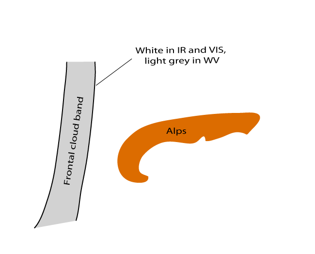
- A front moving north of the Alps, with the cloud band becoming deformed (hooked)
- A front moving across the Alps, one part clearly staying behind (grey in IR and WV, white in VIS) the rest of the frontal cloud band band (white in IR and VIS, light grey in WV)
|
|
|
|

|
|
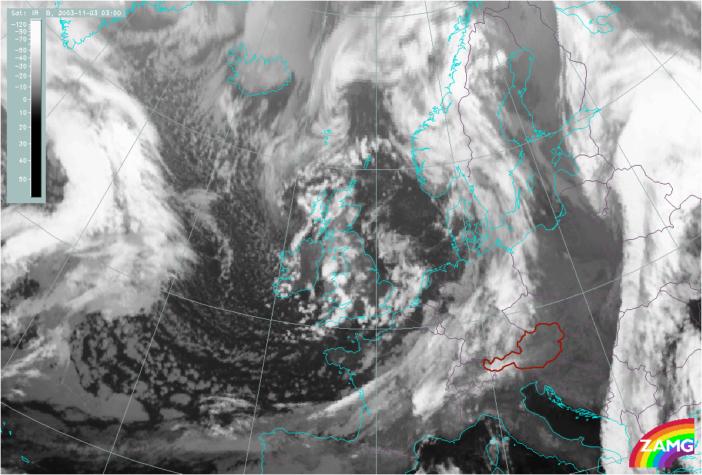
03 November 2003/03.00 UTC - Meteosat IR image; 03.00 UTC - 18.00 UTC hourly image loop
|
03 November 2003/03.00 UTC - Meteosat WV image; 03.00 UTC - 18.00 UTC hourly image loop
|
|
05 May 2003/00.00 UTC - Meteosat IR image; 00.00 UTC - 15.00 UTC hourly image loop
|
05 May 2003/00.00 UTC - Meteosat WV image; 00.00 UTC - 15.00 UTC hourly image loop
|


Decoupling of clouds at different heights
When frontal clouds approach mountain chain decoupling of clouds can be noticed. The upper part passes the mountain, but the surface front is retarded and low level clouds stay behind.
- Frontal cloud band moving over the Alps: bright in IR, VIS and WV
- Frontal cloudiness being decoupled: low level cloudiness, grey in IR and dark grey in WV, bright in VIS
|
|
|

|

|
|
14 November 2003/15.00 UTC - Meteosat IR image; 14 November/15.00 UTC - 15 November/09.00 UTC hourly image loop
|
14 November 2003/15.00 UTC - Meteosat WV image; 14 November/15.00 UTC - 15 November/09.00 UTC hourly image loop
|


Appearance in the RGB composite image
As it is mentioned before, it is not always easy to detect and distinguish front delay or decoupling of clouds at different heights. Combinations and differences of satellite channels enable a deeper insight into the structure of cloudiness and could help us to follow the process.
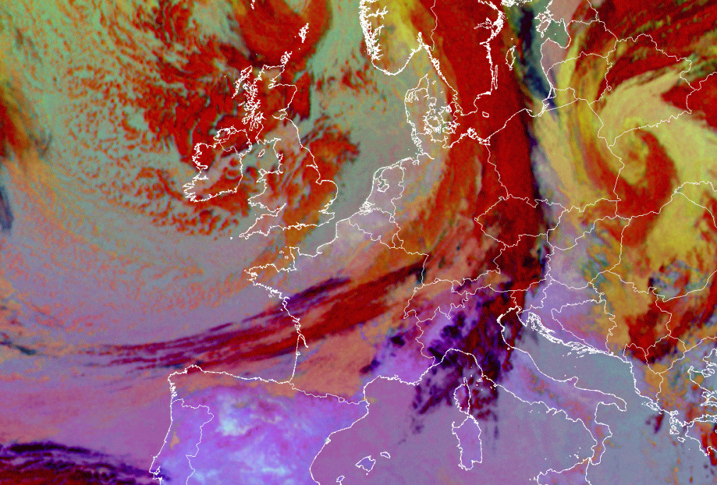
The 24 hours Microphysics RGB is an RGB composite based upon the data from infrared channels and differences as follows: IR12.0 - IR10.8 on red colour, IR10.8 - IR8.7 on green and IR10.8 on blue. As the name declares, it can be used day and night. It is designed and tuned to monitor the evolution of fog and low stratus on one hand, and dust and volcanic ash on the other. Secondary applications of this RGB are the detection of fires and low-level moisture boundaries. However, this RGB makes thick high level ice clouds distinctive in its dark red colour, fog or low stratus in ochre and cloud free areas in pinkish (bluish) colour (worth for Mediterranean region and differs quite a lot depending on the time of the year as can be noticed in the two images below).
|
Front Delay as it appears in Microphysics RGB Image
|
17 July 2009/12.00 UTC - Meteosat 9 Microphysics RGB image; 17 July/12.00 UTC - 18 July/12.00 UTC hourly image loop
|

|

The above image loop shows a nice example of frontal cloud band deceleration - one part passing over the Alps (with retardation of frontal cloudiness - thick frontal cloud band with high level ice clouds in red to dark red colour), and the other part staying behind (ochre to orange colour).
The following 1 hourly loop shows decoupling of clouds at different heights when the front passes the Alps. The first, high cirrus clouds cross the mountain chain (dark blue, almost black colour) and after that, a part of frontal cloudiness (red or dark red colour) moves over the Alps and low level cloudiness (orange to ochre colour) stay behind.
|
Front Decoupling as it appears in Microphysics RGB Image
|
08 March 2009/03.00 - Meteosat 9 Microphysics RGB image; 08 March/03.00 UTC - 09 March/00.00 UTC hourly image loop
|

|

Meteorological Physical Background
Front Delay
Although the impact of orography on the motion of fronts has been recognized quite early (Bjerknes and Solberg, 1926) it is only recently that major research efforts have been directed towards observing and understanding the behaviour of fronts near mountains. Some observations and model simulations show that a front passing the mountain chain will be strongly retarded:
- if the front is shallow
- if the temperature difference across the front is large
- if the wind velocity normal to the front is small
- if the atmosphere is stable stratified.
Also, the relative angle of incidence of the front to the elongated mountain is important. Front Delay occurs in cases where there is a long frontal cloud band which is orientated normal or almost normal to a major mountain chain. In the Alpine region this is the common north-south and northeast-southwest orientation of fronts. Moreover, it is observed that the deformation occurs more often if the front approaches the Alps from the west than if it comes from the northwest.
There was an attempt to find similar substructures in fronts passing the Scandinavian Mountains but none was found. Possible reasons why the Scandinavian mountains do not show Front Delay are that:
- they are not so high
- they have a different orientation (in relation to approaching fronts)
|
01 September 2009/11.00 UTC - Meteosat 8 IR image
|
|

|
If air is being advected towards an obstacle there are two possibilities: either going around or going above. Which possibility dominates depends on wind speed and stratification: low wind speeds inhibit ascent, as does stable stratification. In the cases investigated in this study low wind speeds in lower levels were found, especially at the leading edge of the frontal cloud band. So the cloud band is retarded where it comes into contact with the mountain ridge. Limited Area Model (LAM) fields show that there is flow around an obstacle. The stratification is also stable (but without inversions). The cloud band therefore undergoes deformation and becomes hook-like in appearance.
Clouds are displaced slower in the mountainous region then the surrounding regions. As this phenomenon only lasts several hours, it is more important for nowcasting than for forecasting.
Decoupling of clouds at different heights
The frontal cloud bands approach the mountain chain with the orientation of the cloud band quasi-perpendicular to the mountain chain. The slower the movement, the more difficult it is for a front to pass over the obstacle. This is expressed quantitatively by the Froud number which relates stability with velocity. Fronts which have both stable stratification and slow displacement suffer decoupling of clouds at different layers. The air does not stream around the mountain chain, but stays behind. Only the higher cloudiness (upper level front) which needs not to be excessively elevated can proceed at the original speed of displacement. The different velocities can also be seen by the help of Atmospheric Motion Vectors (AMV) where the low level cloudiness has vectors which are only half the length of those in the area of high cloudiness. Wind (especially of the LAM) has the direction normal to the mountain chain, whereas in case of Front Delay wind vectors in the vicinity of the mountain are parallel to it.
|
15 November 2003/03.00 UTC - Meteosat IR image; cyan: atmospheric motion vectors
|
15 November 2003/04.00 UTC - Meteosat IR image; cyan: atmospheric motion vectors
|

|

|
Problems and open questions
- Both phenomena are quite rarely observed clearly, and are the combination of different effects, the scale (which is much smaller than the whole front), and the short duration (these modifications can develop within a few hours) lead to a lack of precise numerical data.
- A prediction, to show if a front will suffer these modifiactions is not possible. The orientation of the approaching frontal cloud band (at more or less the right angle to mountain chain) as well as key parameters - such as wind speed and stability - give indicators, but these conditions can also occur in cases without front modifications.
- Cloud patterns similar to those of decoupling of frontal clouds at different heights are sometimes observed without the existence of a mountain chain.
- Scandinavian mountains do not show these effects. This can be due to the lower altitude or the different orientation in relation to the prevailing wind direction.
- Cantabrics and Pyrenees do influence frontal clouds as well, but the effect is usually much weaker since the environment is quite different. Namely, on their way to Cantabrics and Pyrenees most fronts move over the ocean from west to east parallel to the mountain chains.
Key Parameters
Front Delay
General frontal characteristics and the specifics for the frontal delay are given by the following key parameters:
- TFP, Equivalent thickness and Temperature advection at 700 hPa, all of the parameters necessary to interpret Conceptual Model of a Cold Front (see Cold Front - Key Parameters ).
- Wind in lower troposphere, namely at 1000, 850 and 700 hPa
- (Relative) humidity in lower and upper troposphere
|
|
03 November 2003/12.00 UTC - Meteosat IR image; red dashed: temperature advection - CA 700 hPa, red solid: temperature advection -
WA 700 hPa, green: equivalent thickness
|

|

|
|
|
03 November 2003/12.00 UTC - Meteosat IR image; blue: TFP
|

|

|
|
|
03 November 2003/12.00 UTC - Meteosat IR image; red: wind vectors 700 hPa
|

|

|
Since the details of the flow are of great importance to understand the mechanisms of the orographic effects on frontal cloud bands, LAM wind fields are much more suitable to get the insight into the frontal characteristics.
- Wind in higher troposphere is not influenced by the orography and shows the general flow which, in the case favourable for any kind of deformation of a frontal cloud, is westerly.
- At 700 hPa near to the orographic barrier, wind is backing to south-westerly direction. Also, a high horizontal gradient in the area of the delay is observed.
- At 850 hPa a significant disturbance by the mountain chain is evident. Generally, wind speeds are much reduced ahead of the frontal surface.
|
03 November 2003/12.00 UTC - LAM ALADIN; wind vectors 850 hPa
|
03 November 2003/12.00 UTC - LAM ALADIN; wind vectors 700 hPa
|

|

|
Model fields can also give the insight in separation of cloudiness at different levels.
|
17 July 2009/15.00 UTC - Meteosat 9 Microphysics RGB image
|
18 July 2009/12.00 UTC - Meteosat 9 Microphysics RGB image
|

|

|

|

|
|
17 July 2009/15.00 UTC - LAM ALADIN; low (orange), middle (violet) and high (light blue) clouds as seen from the ground
|
18 July 2009/12.00 UTC - LAM ALADIN: low (orange), middle (violet) and high (light blue) clouds as seen from the ground
|
Cloudiness field shows a compact frontal cloud band approaching the Alps. 21 hours later the front has passed, mainly north of the barrier, while low clouds are kept behind the mountain chain. Moreover, the separation of the front in different vertical levels is nicely depicted by humidity fields.
|
17 July 2009/18.00 UTC - LAM ALADIN; relative humidity at 500 hPa
|
18 July 2009/15.00 UTC - LAM ALADIN; relative humidity at 500 hPa
|

|

|

|

|
|
17 July 2009/18.00 UTC - LAM ALADIN; relative humidity at 950 hPa
|
18 July 2009/15.00 UTC - LAM ALADIN; relative humidity at 950 hPa
|
Decoupling of clouds at different heights
Analogously to the case of the Front Delay general frontal characteristics are given by the following key parameters:
- TFP, Equivalent thickness and Temperature advection at 700 hPa, all of the parameters necessary to interpret Conceptual Model of a Cold Front (see Cold Front - Key Parameters ).
- Wind in lower troposphere, namely at 1000, 850 and 700 hPa
- (Relative) humidity in lower and upper troposphere
|
|
07 January 2004/12.00 UTC - Meteosat IR image; red: wind vectors at 700 hPa
|

|

|
|
07 January 2004/12.00 UTC - LAM ALADIN; wind vectors 700 hPa
|
07 January 2004/12.00 UTC - LAM ALADIN; wind vectors 850 hPa
|

|

|
Considering the flow favourable for the decoupling of the frontal cloud, one has to pay attention to the following:
- Equivalently to the conditions of front delay, the wind in higher troposphere is not influenced by the orography and shows the general flow which, in the case favourable for any kind of deformation of a frontal cloud, is westerly.
- At 700 hPa near to the orographic barrier, wind is veering to north-westerly direction.
- Wind field clearly shows the location of the different parts of the front: decreasing at the boundary between high and low cloudiness.
- At the lower levels (850 hPa) wind speed is significantly reduced. Moreover, different velocities at different levels once again point out on decoupling of clouds.
|
08 March 2009/06.00 UTC - Meteosat 9 Microphysics RGB image
|
08 March 2009/15.00 UTC - Meteosat 9 Microphysics RGB image
|

|

|

|

|
|
08 March 2009/06.00 UTC - LAM ALADIN; low (orange), middle (violet) and high clouds as seen from the ground
|
08 March 2009/15.00 UTC - LAM ALADIN: low (orange), middle (violet) and high (light blue) clouds as seen from the ground
|
What is seen as the clouds essentially is humidity throughout the troposphere. Therefore, the humidity fields can testify that, as the front progresses to the west, only the humidity at 500 hPa gets advected by the upper level flow, while middle and especially the low ones (depicted by humidity of 950 hPa level) is retained behind the obstacle.
|
08 March 2009/06.00 UTC - LAM ALADIN; relative humidity at 500 hPa
|
08 March 2009/15.00 UTC - LAM ALADIN; relative humidity at 500 hPa
|

|

|

|

|
|
08 March 2009/06.00 UTC - LAM ALADIN; relative humidity at 950 hPa
|
08 March 2009/15.00 UTC - LAM ALADIN; relative humidity at 950 hPa
|
Typical Appearance In Vertical Cross Sections
Front Delay
Because the spatial resolution of the global ECMWF model is not high enough to capture the fine structures of the atmosphere over and around the mountain, vertical cross sections of meso-scale model ALADIN are used.
- Isentropes show the characteristics of a typical cold front - a downward inclined (frontal) zone shows a part of the cloudiness that passed over the Alps. Quasi-parallel isentropes behind the mountain chain indicate the stable stratification at the windward side of the orographic barrier
- Relative humidity, in accordance with cloud pattern
- Omega: strong upward motion at the leading edge of the frontal zone and a pronounced sinking behind it clearly shows that the upper part of the front progresses to the west more or less undisturbed. Within the clouds kept behind the mountain chain the vertical motion is much weaker, but still mostly rising showing that there is still a part of the front that needs to pass the obstacle.
|
Position of vertical cross section
|
18 July 2009/09.00 UTC - Meteosat 9 IR image; position of vertical cross section indicated
|

|

|
|
|
18 July 2009/09.00 UTC - Vertical cross sections; isentropes: black
|

|

|
|
|
18 July 2009/09.00 UTC - Vertical cross sections; grey: relative humidity < 60%, blue: relative humidity > 60%
|

|

|
|
|
18 July 2009/00.00 UTC - Vertical cross sections; blue; omega > 0 (downward motion), yellow; omega < 0 (upward motion)
|

|

|
Decoupling of clouds at different heights
Analysis of vertical structure of the atmosphere in a case of decoupling of clouds at different heights is again presented through vertical cross sections of a LAM model.
- Isentropes show the characteristics of a typical cold front - a downward inclined (frontal) zone shows a part of the cloudiness that passed over the Alps. Quasi-parallel isentropes ahead of the mountain chain indicate the stable stratification in the area not jet reached by the front
- Relative humidity, in accordance with cloud pattern; high clouds already passed, a part of middle too, and the rest of the clouds (mostly low) are retained behind the obstacle
- Omega: a typical frontal distribution of vertical motion can be found in the middle and upper levels. However, even stronger ascent behind and over the Alps indicates there is still a significant part of the frontal cloud which needs to pass the barrier.
|
Position of vertical cross section
|
09 March 2009/03.00 UTC - Meteosat 9 IR image; position of vertical cross section indicated
|

|

|
|
|
09 March 2009/03.00 UTC - Vertical cross sections; isentropes: black
|

|

|
|
|
09 March 2009/03.00 UTC - Vertical cross sections; grey: relative humidity < 60%, blue: relative humidity > 60%
|

|

|
|
|
09 March 2009/03.00 UTC - Vertical cross sections; blue; omega > 0 (downward motion), yellow; omega < 0 (upward motion)
|

|

|
Weather Events
Front Delay
| Parameter | Description |
| Precipitation |
|
| Temperature |
|
| Wind (incl. gusts) |
|
| Other relevant information |
|
|
06 May 2003/06.00 UTC - Meteosat IR image; weather events (green: rain and showers, blue: drizzle, cyan: snow, red: thunderstorm,
black: no precipitation)
|
|

|
Decoupling of clouds at different heights
| Parameter | Description |
| Precipitation |
|
| Temperature |
|
| Wind (incl. gusts) |
|
| Other relevant information |
|
|
07 January 2004/00.00 UTC - Meteosat IR image; weather events (green: rain and showers, blue: drizzle, cyan: snow, red:
thunderstorm, black: no precipitation)
|
|

|
References
General Meteorology and Basics
- EGGER J. and HOINKA K. P., 1992: Fronts and Orography. Meteorology and Atmospheric Physics: Vol. 48, No. 1-4, pp. 3-36.
- BLUMEN W., 1992: Propagation of fronts and Frontogenesis Versus Frontolysis over Orography. Meteorology and Atmospheric Physics: Vol. 48, No. 1-4, pp. 37-50.
- HOINKA K. P. and VOLKERT H., 1992: Fronts and the Alps: Findings from the Front Experiment 1987. Meteorology and Atmospheric Physics: Vol. 48, No. 1-4, pp. 51-75.
- KEULER K., KERKMANN J., KRAUS H. and SCHALLER E., 1992: Orographical Modification and Large Scale Forcing of a Cold Front. Meteorology and Atmospheric Physics: Vol. 48, No. 1-4, pp. 105-130.
- TAFFERNER A. and EGGER J., 1992: Modification of Fronts by the Alps: Simulations and Numerical Experimentation. Meteorology and Atmospheric Physics: Vol. 48, No. 1-4, pp. 193-203.
- SCHUMANN U., 1987: Influence of Mesoscale Orography on Idealized Cold Fronts. Journal of the Atmospheric Science: Vol. 44, No. 23, pp. 3423-3441.