Table of Contents
Cloud Structure In Satellite Images
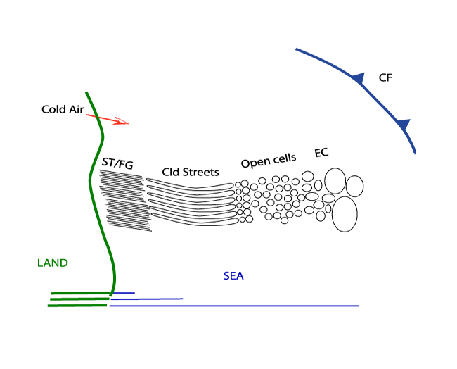
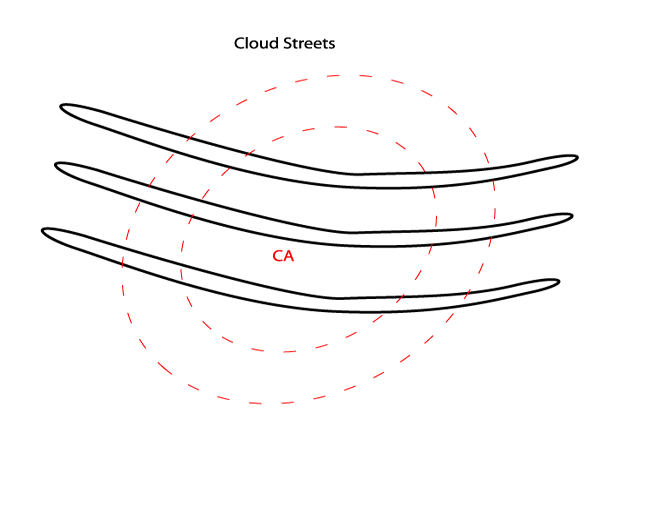
Cold Air Cloudiness is the result of mesoscale shallow convection (1-2 km deep) and has distinctive appearances: Linear and Hexagonal. The
former is called Cloud Streets, which will be discussed more deeply and can be roughly regarded as 2-dimensional convection. The latter,
generally called in the literature Mesoscale Cellular Convection, is characterized by 3-dimensional convection which can be divided in two
types: Open and Closed Cells.
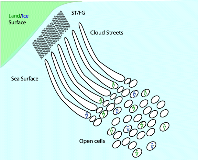
A distinct life-cycle can be seen from Stratus/Sea-Fog to Cloud Streets, especially over sea surfaces during Cold Air Outbreaks from
neighbouring continents, most frequently ending up as Open Cells.
|
|
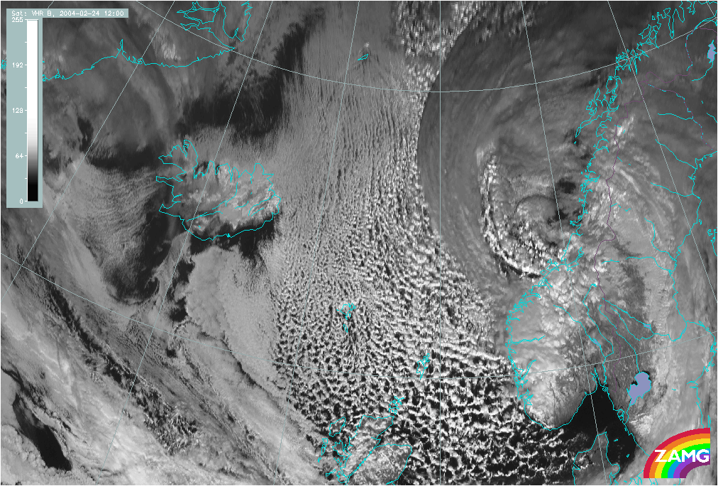
24 February 2004/12.00 UTC - Meteosat Hires VIS image
|
|
|
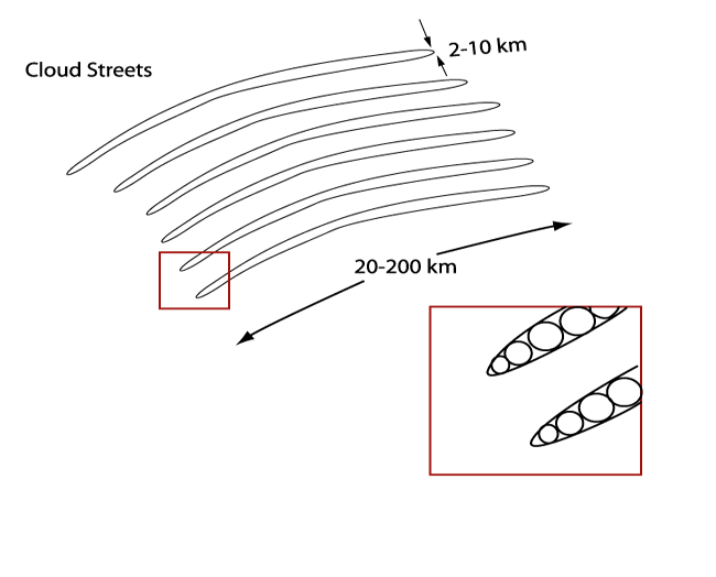
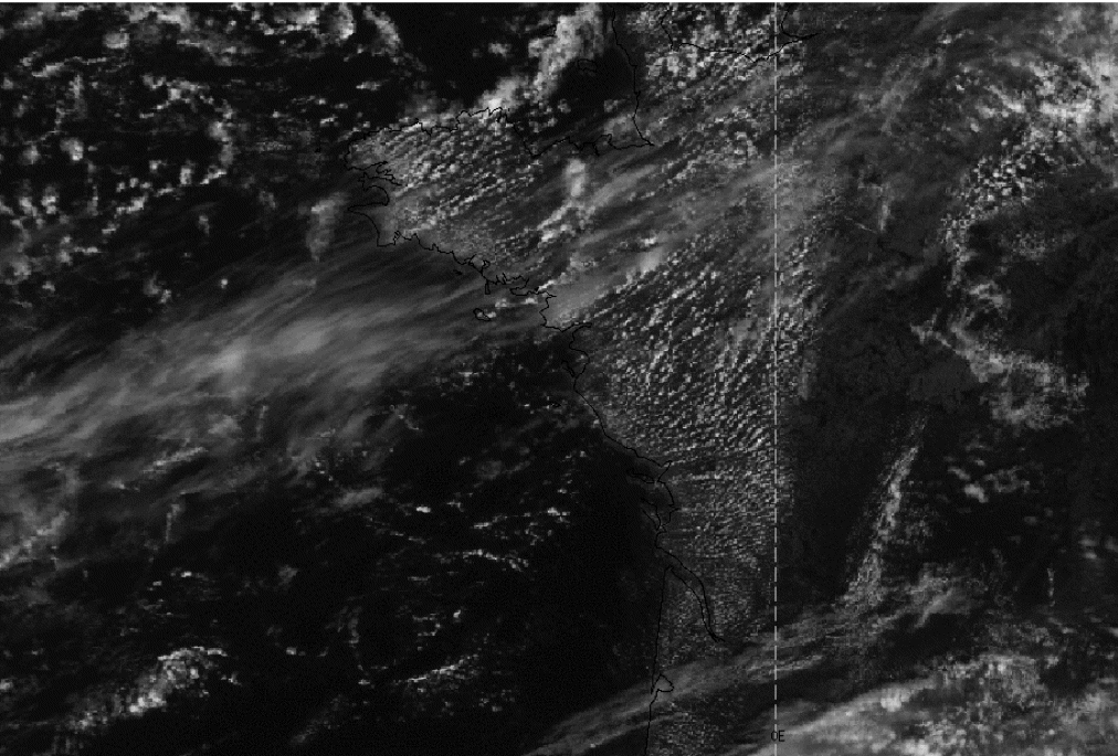
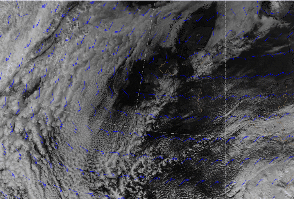
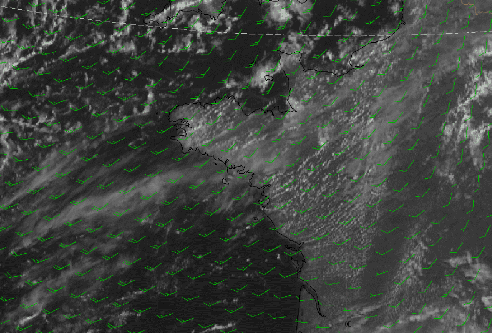
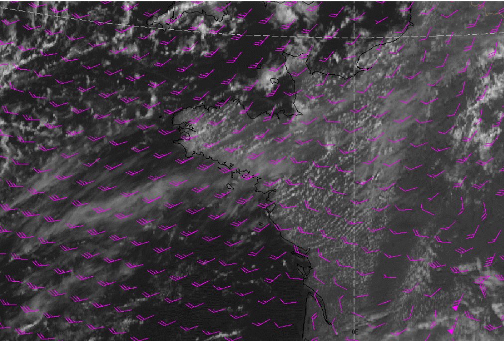
Cloud Streets occur over both water and land surfaces. The satellite image shows several parallel cloudbands with a length of 20-200 km and width of 2-10 km. Especially over the sea, the streets become wider with increasing distance from shore. The cloud bands consist of individual cumuli which are lined up like pearls on a string.
Appearance in Meteosat images:
- Cloud Streets can be detected in Meteosat7 VIS imagery, but because of the rather course resolution, the detailed structure isn't easily seen. In Meteosat 7 IR imagery Cloud Streets can't be easily seen because the convection is limited to the lower levels of the troposphere. In Meteosat WV imagery Cloud Streets cannot be seen at all, again because of the latter reason. In Meteosat 8 HiresVIS imagery they can clearly be seen as parallel white cloudbands, because of the better resolution of this new imagery
|
23 August 2004/11.00 UTC - Meteosat VIS
|
23 August 2004/11.00 UTC - Meteosat Hires VIS
|
|

|
|
|
|
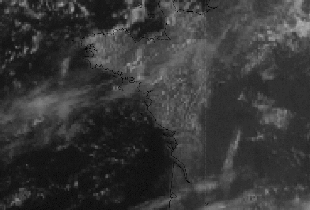
23 August 2004/11.00 UTC - NOAA Ch1 image
|
|
The NOAA AVHRR examples above show Cloud Streets over SW France, in Meteosat 7 imagery the indiviual streets cannot be distinguished. In NOAA and Meteosat 8 (HiresVis) imagery, the detailed structure can be observed well.
|
19 February 2004/12.29 UTC - NOAA RGB image
|
|

|
Meteorological Physical Background
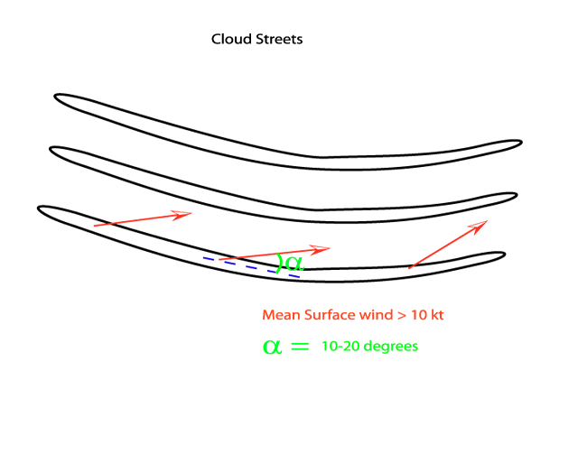
The organisation of clouds into rows can be explained by the existence of horizontal roll vortices in the boundary layer. The clouds are formed in the upward parts of this roll system. The formation of Cloud Streets by this roll development are mainly caused by two types of instability: dynamic (inflection) and thermal instability. These kind of instabilities may act independently, but can hardly be distinguished in a real flow.
Inflection instability is caused by an inflection point in the wind velocity component perpendicular to the roll system. This inflection point is caused by a combination of the Ekman-layer shear-flow and cold advection. As a result of friction, the winds in the lowest levels will veer with height. The friction-effect decreases with increasing height and therefore the wind will tend to back again because of the cold advection which is present. As a consequence of this turning wind vector, in the lowest layers, a roll system develops.
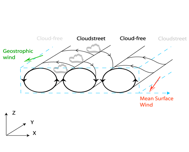
The inflection point instability can develop in neutral or even slightly stable stratification of the lower troposphere. However, Cloud Streets usually occur under unstable stratification, bounded by an inversion layer above (Thermal Instability). This instability is usually created when cold air flows over a relatively warm surface. Therefore it is most likely that the two types of instabilities can act together, leading to vortex-roll development and the formation of Cloud Streets. Brown (1972) found that under unstable stratification, the inflection instability is enhanced by the thermal instability. Whether inflection instability or thermal instability is more dominant for Cloud Street formation is still a matter of discussion.
Synoptic Environment and Characteristics
In the following paragraphs the typical synoptic environment and other characterisitics will be discussed.
Cloud Streets over sea:
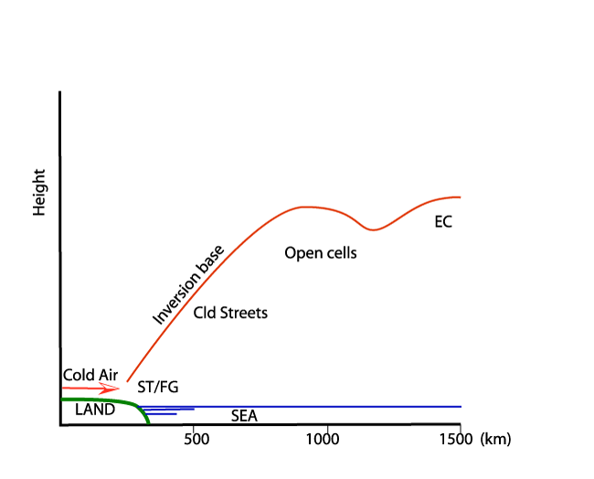
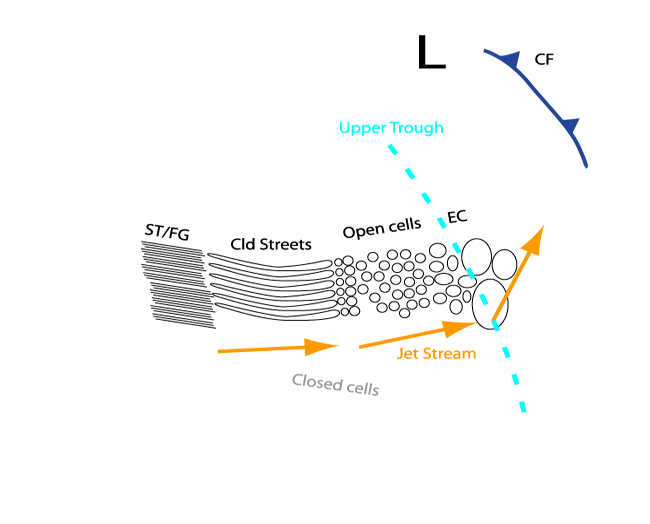
In many cases Cloud Streets can be seen during synoptic scale outbreaks of cold, dry air from continents over a neighbouring relatively warm
ocean. This flow often occurs behind a Cold front (see
Cold Front
). As the cold air leaves the land or ice surface it is modified by vertical transfer of heat and moisture from the underlying water surface.
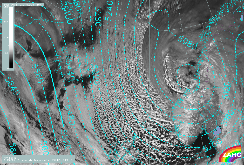
An inversion will be formed the base of which rises with the distance from shore. The formation of the inversion is, in many cases, stimulated
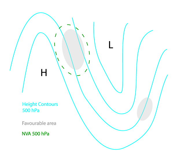
by NVA and subsequent sinking motion in the stream upwind of the 500 hPa trough-axis (see image below).
The transformation of the air mass eventually leads to the formation of clouds which, under certain circumstances, take the form of Cloud
Streets, and develop roughly parallel to the wind direction (see graphic below). Further downwind from the outbreak, the unstable layer becomes
deeper, the flow becomes more cyclonic and the streets develop into three-dimensional open cells. Near the upper-trough the convection is
enhanced by PVA, resulting in the formation of EC (see
Enhanced Cumulus
) and Comma (see
Comma
).
|
|
|
|
|
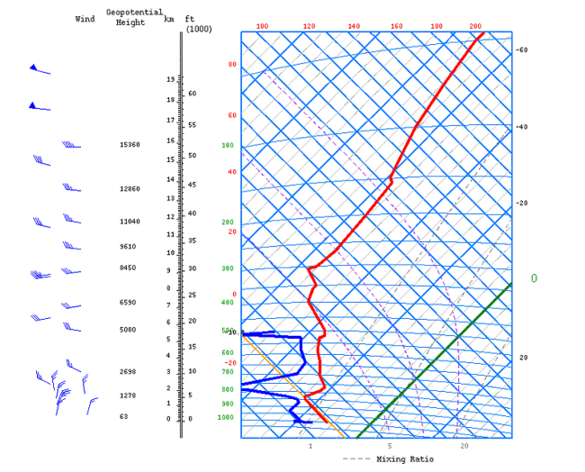
Good examples of Cloud Streets often occur over the Atlantic Ocean when cold dry continental air from Greenland flows out over the relatively warm sea.
|
07 March 2003/12.04 UTC - NOAA RGB image
|
07 March 2003/12.00 UTC - Tephigram Jan Mayen
|

|
|
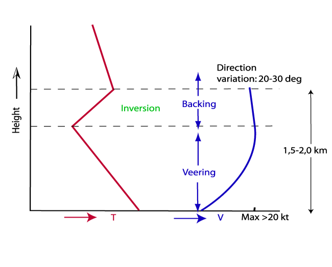
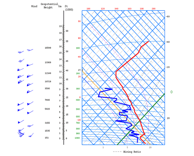
In the tephigram it can be seen that the lowest 2 km (about 1000-800 hPa) has unstable stratification. This unstable layer is capped by a sharp inversion. Further, it can be seen that the winds in the unstable layer show a slight variation in direction with height: In the lowest half of the unstable layer the winds are veering with height, in the upper half the winds are backing again. This wind profile shows the required inflection point in the cross component of the wind, allowing the formation of roll-vortices and subsequent Cloud Streets. Furthermore, it can be seen from the tephigram and the table below that the windspeed is quite constant with height with values over 20 kt in the middle of the unstable layer.
| Height (hPa) | Winddirection (Deg) | Windspeed (kt) |
| 1007 | 010 | 17 |
| 1000 | 015 | 17 |
| 925 | 020 | 23 |
| 850 | 350 | 25 |
| 772 | 295 | 23 |
| 700 | 295 | 23 |
Over Land:
Cloud Streets also occur over land surfaces. Frequent examples of this type of Cloud Street occur in polar maritime air behind Cold Fonts, when
a ridge of high pressure is forming. Heating of the land surface enhances the instability in the lowest layers. The high pressure provides the
subsidence inversion which is needed to limit the convection. Furthermore, because of the cold advection the condition of the turning wind
vector is also fulfilled and Cloud Streets can develop. As a consequence of a larger variation in terrain roughness, the pattern of the Cloud
Streets is less regular than over sea.
|
19 February 2004/12.00 UTC - NOAA Ch1 image, Surface/Geostrophic wind
|
|
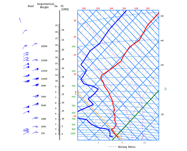
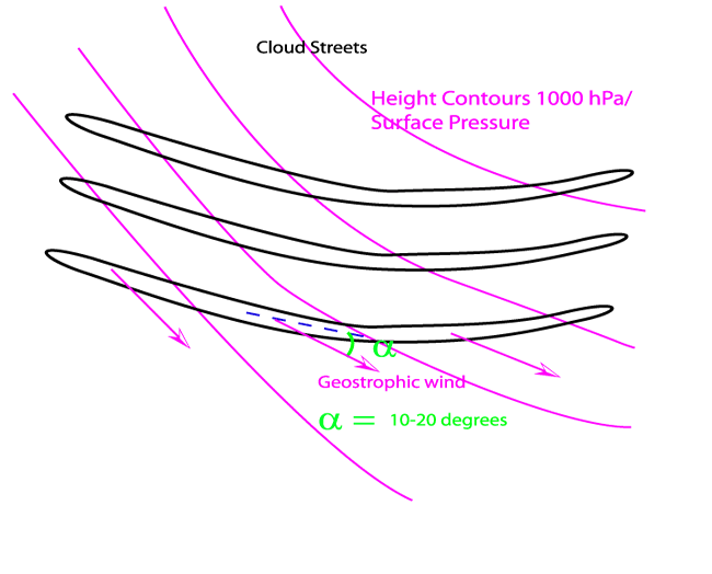
In the example above Cloud Streets can be seen over The Netherlands, NW Germany, the middle part of the UK and over NW France. This situation was characterised by a cold air outbreak behind a Cold Front. Furthermore, it can be seen that the surface wind is orientated following the left side of the Cloud Streets, whereas the geostrophic wind is orientated following the right side of the Cloud Streets. In this case Cloud Streets can be seen both over land and over water. If the fetch over the sea becomes larger, the organisation of the convection turns into a cellular structure. In the English Channel, a Convergence Line has developed. (See Convergence lines over Sea or lakes ). A tephigram of De Bilt shows well the characteristics favourable for Street development. Again, the required inflection point in the cross component of the wind in the unstable layer can be seen.
|
19 February 2004/12.00 UTC - Tephigram De Bilt
|
|
|
| Height (hPa) | Winddirection (Deg) | Windspeed (kt) |
| 1028 | 060 | 12 |
| 1000 | 065 | 25 |
| 925 | 080 | 25 |
| 850 | 075 | 35 |
| 700 | 065 | 45 |
Key Parameters
- Surface Wind
Surface winds have to be moderate to strong, in all cases the surface winds are between 10-20 kt. Furthermore, the surface wind is aligned with the left hand side of the Cloud Streets. - Height Contours 1000 hPa/Geostrophic wind
The geostrophic wind is usually aligned with the right hand side of the Cloud Streets, this can also be shown by the height contours at 1000 hPa because the geostrophic wind is orientated parallel to the height contours. - Instability/laps rate
In the layer in which the Cloud Streets form the whole profile has an unstable character - Height of the Unstable Layer
Generally, the depth of the unstable layer has a height of 1.5-2.0 km, and is usually capped by a sharp inversion. The best way to identify this is by using radiosonde plots. - Wind profile in unstable layer
The wind direction often shows a curved profile: in the lowest part of the unstable layer the winds are veering, from the mid-level the winds are backing again. The variation in direction is, however, not very large and usually the winds in the unstable layer vary no more than 20-30 degrees. The wind speed should increase with height to a maximum of at least 20 kt in the middle or upper part of the convection layer. Above these levels the wind may decrease or increase. Numerical prediction models do not represent this small scale variation of the wind well because of their coarser resolution. - Temperature Advection 1000/850 hPa
Cloud Streets usually develop under slight cold advection, which often occurs to the rear of a Cold Front. Usually the advection shows a maximum near the middle of the unstable layer. - Height Contours
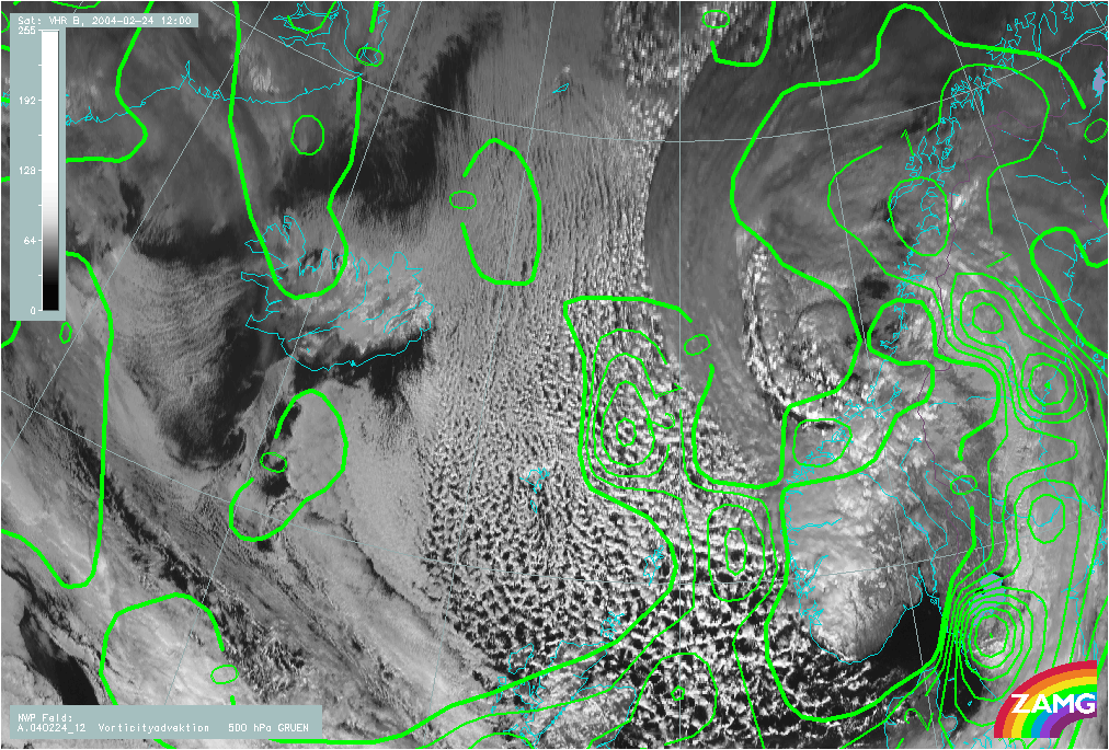
Usually the height contours are rather straight or slightly anticyclonically curved. In cases over the sea, the most developed and extensive area of Cloud Streets are located upstream from the upper-level trough. - NVA 500 hPa
In most cases, because of the influence of a building or approaching upper ridge, NVA is found.
Surface Wind
|
|
23 August 2004/21.00 UTC - Meteosat Hires VIS image; green: surface wind
|
|
|
|
|
|
|
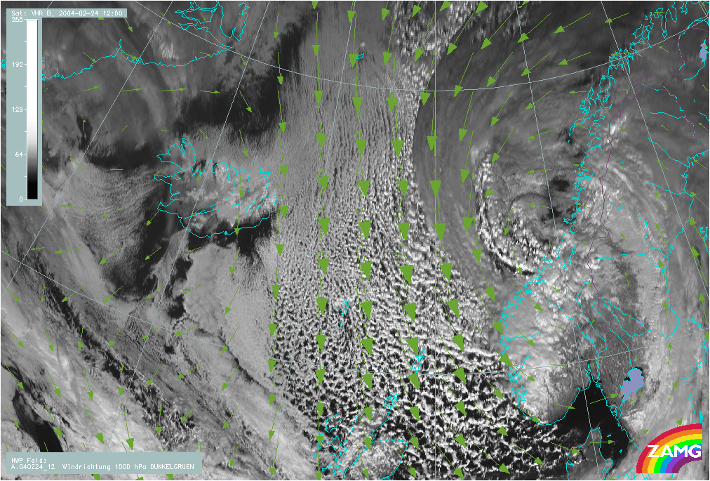
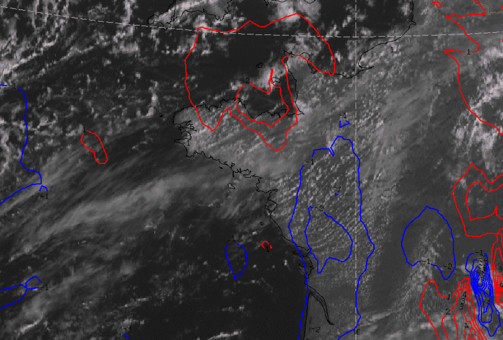
24 February 2004/12.00 UTC - Meteosat 8 Hires VIS image; green: surface wind
|
|
|
23 August 2004/12.00 UTC - Meteosat 8 Hires VIS image; magenta: geostrophic wind
|
|
|
|
|
|
|
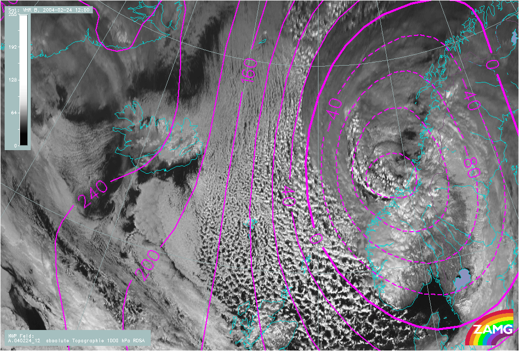
24 February 2004/12.00 UTC - Meteosat 8 Hires VIS image; magenta: Height Contours 1000 hPa
|
|
|
23 August /12.00 UTC - Tephigram Bordeaux
|
|
|
| Height (hPa) | Wind direction (Deg) | Wind speed (kt) |
| 1012 | 285 | 10 |
| 1000 | 295 | 11 |
| 925 | 300 | 12 |
| 910 | 290 | 13 |
| 890 | 265 | 20 |
| 850 | 220 | 25 |
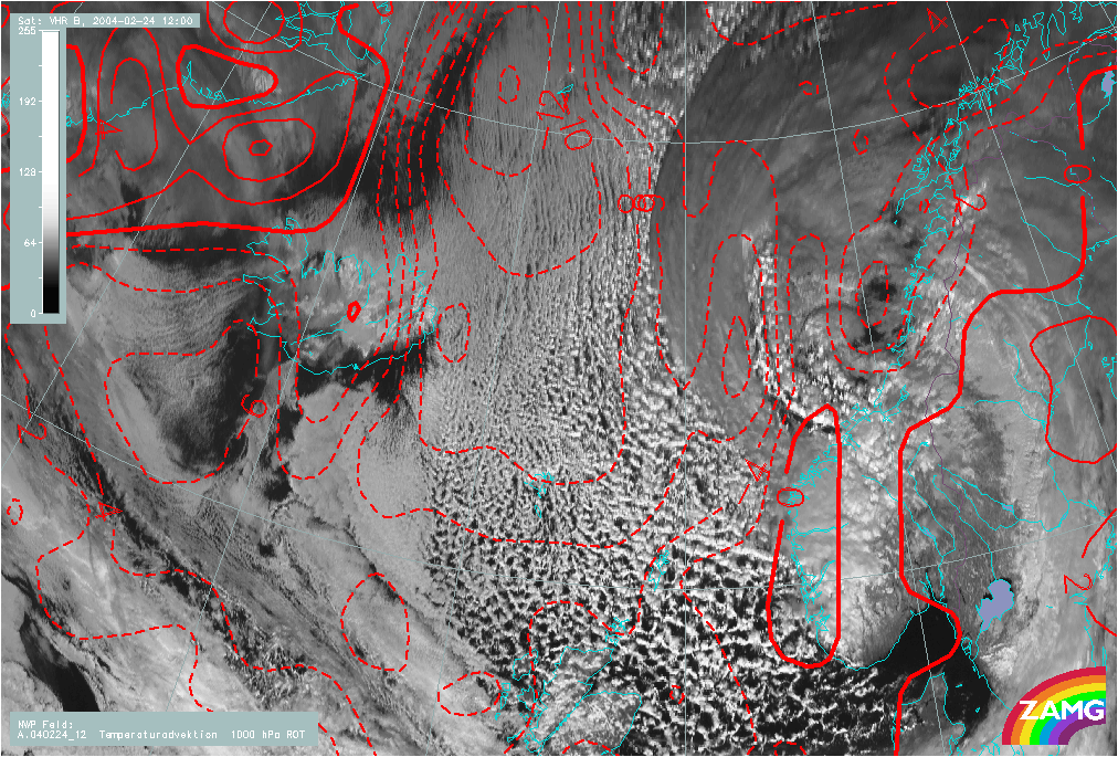
Temperature Advection 1000/850 hPa
|
|
24 February 2004/12.00 UTC - Meteosat 8 Hires VIS image; blue: Height Contours 500 hPa
|
|
|
|
|
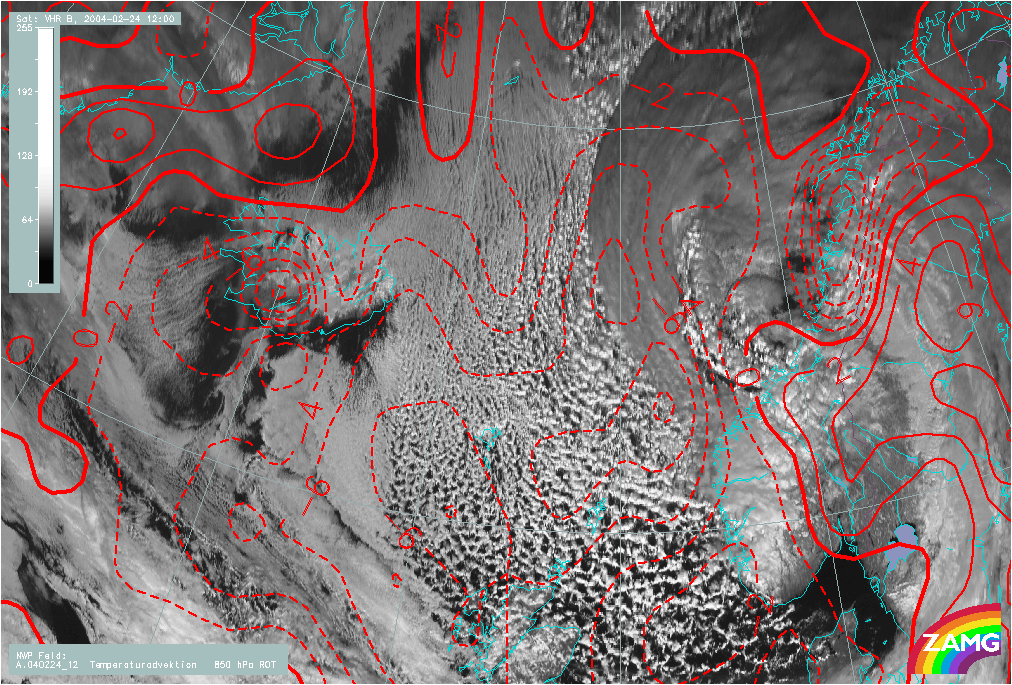
Height Contours and NVA
|
|
23 August 2004/12.00 UTC - Meteosat 8 Hires VIS image; blue: Negative temperature advection 1000-500 hPa
|
|
|
|
|
|
|
24 February 2004/12.00 UTC - Meteosat 8 Hires VIS image; green: PVA
|
Typical Appearance In Vertical Cross Sections
The dynamics of Cloud Streets generally differ totally from the other conceptual models described in this manual. Most of the essential processes take place in the lowest 1 - 2 kilometres, the processes themselves are in the range of micro/meso scale rather than baroclinic at the synoptic scale. However cross sections can help to detect the synoptic environment in which Cloud Streets can develop.
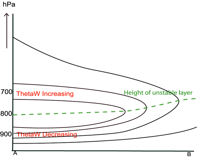
- ΘW
The typical restricted instability can be easily detected in the isentropes. In the lowest levels the potential wet bulb temperature decreases with height, indicating unstable stratification. Around a mean level of 800 hPa, 2 km, wet bulb potential temperature starts to rise again, indicating a change to a stable stratification or inversion. - Wind
In the unstable layer, the winds tend to increase with height and usually show a wind profile that slightly veers with height. However, numerical models do not always show the small scale wind variations which can be found from radiosonde data (dicussed in the Meteorological Physical Background). - Temperature advection
Cloud Streets usually occur in an outbreak of cold air, behind cold fronts in areas of cold advection. The maximum of cold advection can be found in the middle of the convective layer.
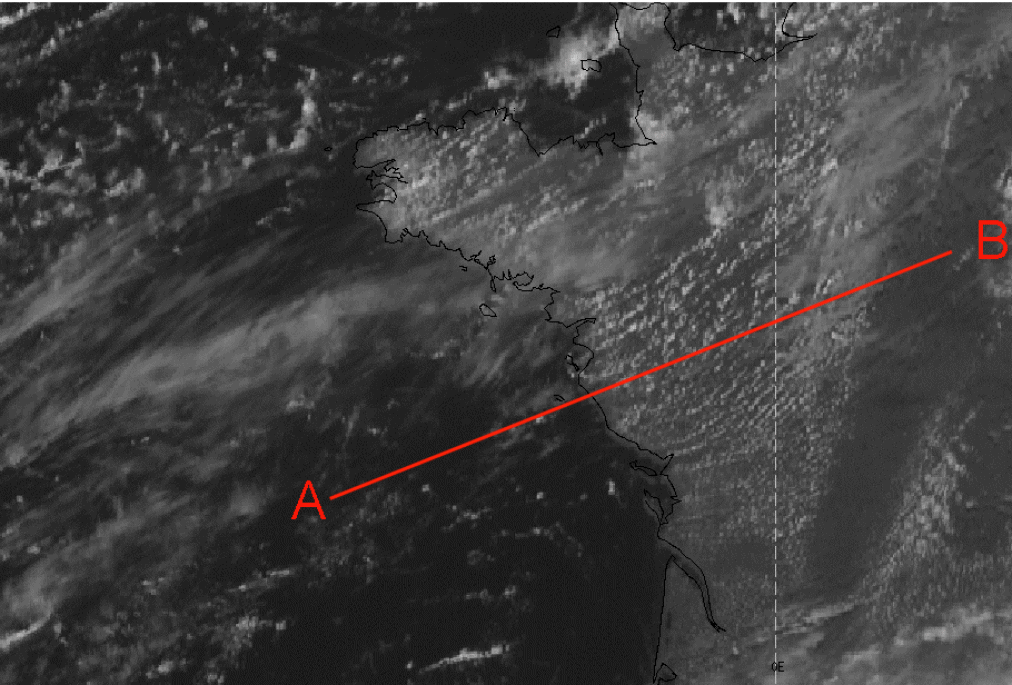
|
|
23 August 2004/12.00 UTC - Meteosat 8 Hires VIS image; position of vertical cross section indicated
|
|
ΘW
|
|
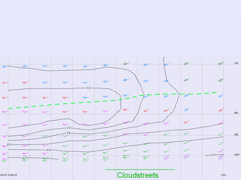
23 August 2004/12.00 UTC - Vertical cross section; horizontal wind barbs and black: isolines of Θw
|
|
|
|
|
|
|
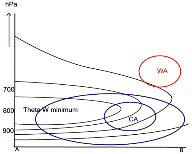
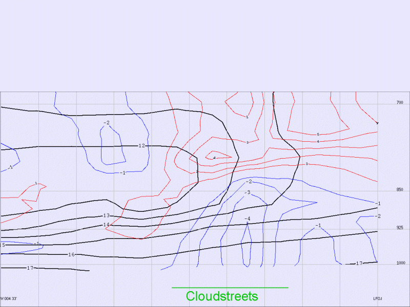
23 August 2004/12.00 UTC - Vertical cross section; black: isolines of Θw, Red WA, Blue CA
|
Weather Events
| Parameter | Description |
| Precipitation |
|
| Temperature |
|
| Wind (incl. gusts) |
|
| Other relevant information | None |
|
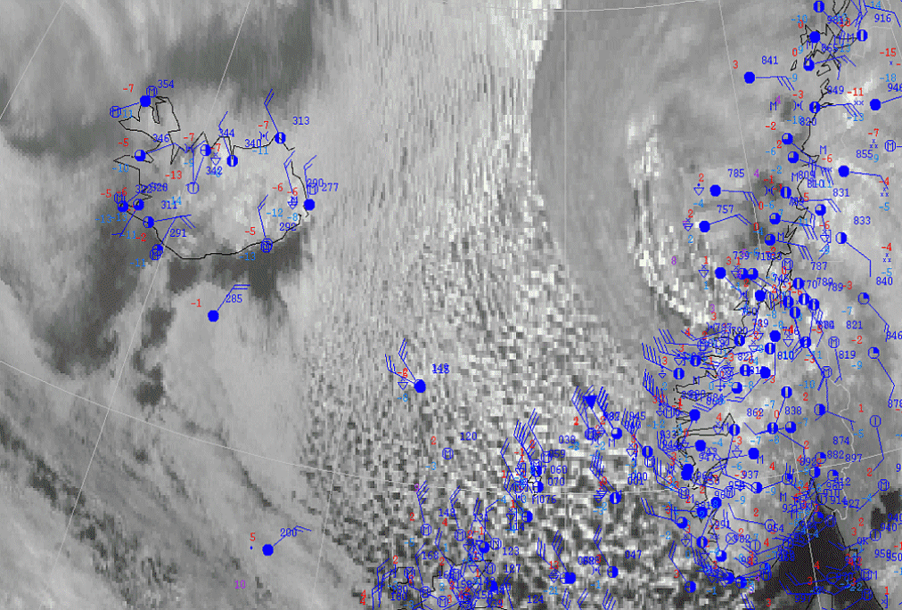
|
24 February 2004/12.00 UTC - Meteosat 7 VIS image; Surface Observations superimposed
|
|
|
References
- LILLY D. K. (1966): On the stability of the Ekman boundary flow; J. Atmos. Sci., Vol. 23, p. 481 - 494
- BROWN R. A. (1979): A secondary flow model for the planetary boundary layer; J. Atmos. Sci., Vol. 27, p. 742 - 757
- ETLING D. (1971): The stability of the Ekman boundary layer flow as influenced by thermal stratification; Contr. Atmos. Phys., Vol. 44, p. 168 - 186
- WMO, Technical Note No. 158. WMO-No. 495 (1993); Handbook of meteorological forecasting for soaring flight
- MULLER, D. (1985): On the occurrence of cloud streets over northern Germany; Quart J.R. Met. Soc. Vol 111, p. 761-772
- Atkinson, B.W., Wu Zhang, J., 1996: Mesoscale shallow convection in the atmosphere. Rev. of Geoph. 34, 403-431
- Etling, D., Brown, R.A., 1993: Roll vortices in the planetary boundary layer: a review. Bound. Lay. Meteor. 65, 215-248