Table of Contents
Cloud Structure In Satellite Images
The identification and analysis of mescoscale convective complexes (MCC) can be done by combining satellite images from different channels. RGB combinations, such as from MSG, are useful in the interpretation of convective systems. MSG's field of view over western South America is limited, but RGBs on the eastern coast of South America and Brazil are very useful. An example of this use is shown for South Atlantic Convergence Zone (SACZ). It is also possible to analyze many aspects with the help of geostationary satellite such as GOES.
The channels from GOES Imager are presented in the table below:
| Channel Number | Wavelength Range (μm) | Range of Measurement | Meteorological Objective |
|---|---|---|---|
| 1 | 0.52 to 0.71 | 0 to 100% albedo | Cloud cover |
| 2 | 3.73 to 4.07 | 4 to 335K | Nighttime clouds |
| 3 | 13.00 to 13.70 | 4 to 320K | Cloud cover and height |
| 4 | 10.20 to 11.20 | 4 to 320K | Sea surface temperature and water vapor |
| 5 | 5.80 to 7.30 | 4 to 320K | Water Vapor |
Features often associated with MCCs in satellite images:
- 1. Mesoscale convective complexes (MCC):
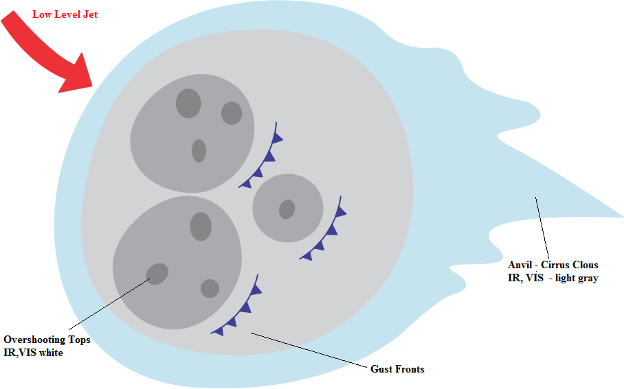
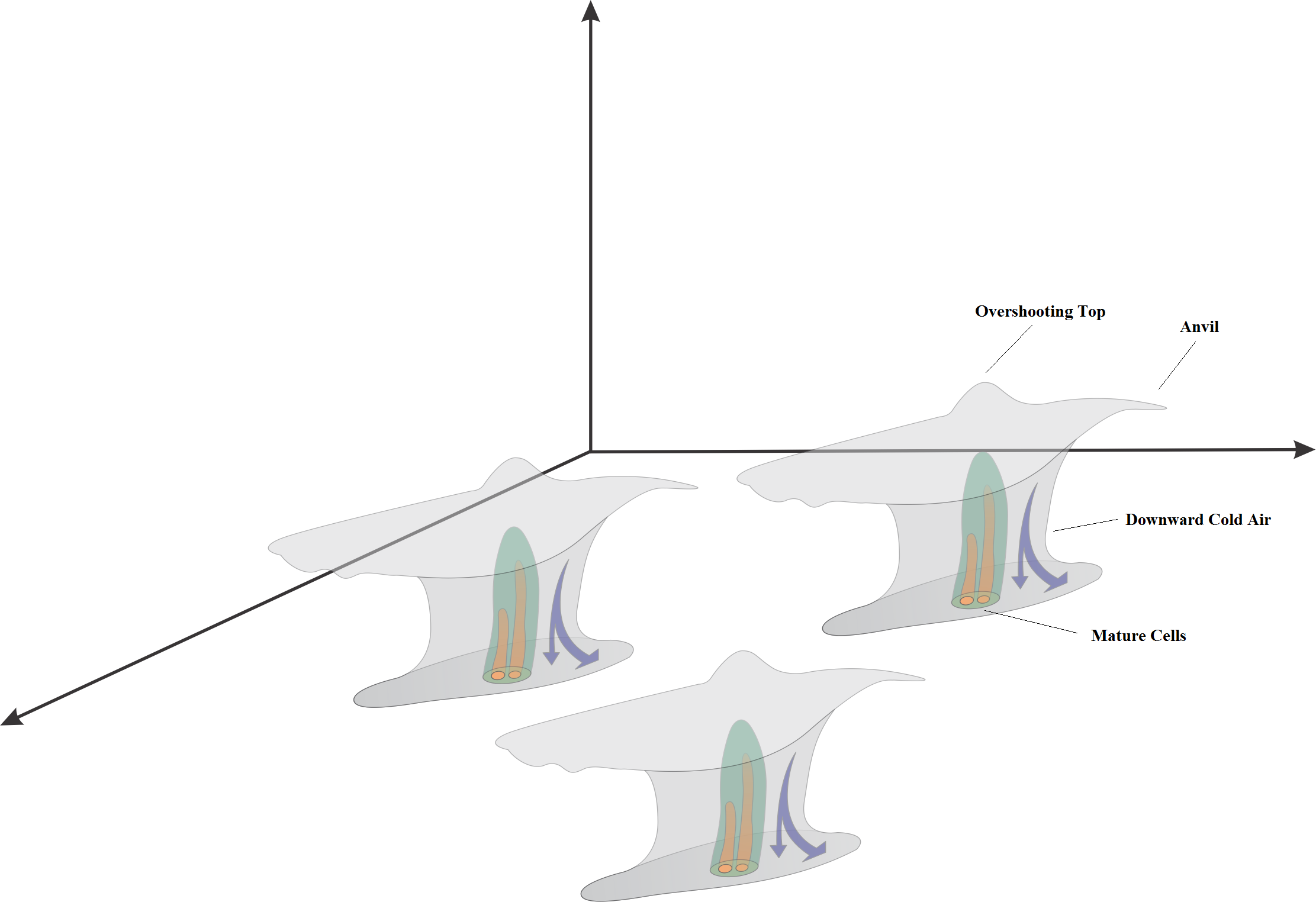
these systems are organized clusters of deep convective clouds. They typically have a circular shape and cover an extensive area. They have a low brightness temperature and a high temperature gradient at the edges, which are visible in enhanced IR imagery. Due to deep convection, MCC have bright cold cloud tops in IR and WV and high albedo in VIS images. VIS images often reveal overshooting tops in the MCC, which, when seen in combination with enhanced IR images, makes it possible to identify the most convective and active parts of the MCC. - 2. Connection with low-level jets (LLJ):
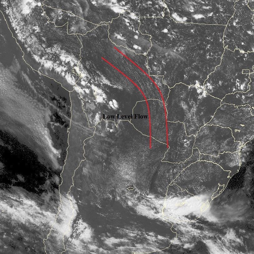
MCC are generally accompanied by a LLJ. The presence of a LLJ can be seen in VIS images on the day (or hours) before the MCC forms. As explained in the SALLJ conceptual models made by CoE Argentina, there are cloud streets organized into lines parallel to the low-level wind resulting from convective rolls within SALLJ.
|
17 November 2009, 18:00 UTC - GOES 10 - Channel 1 (0.65 μm) Visible Image - SALLJ identification.
|
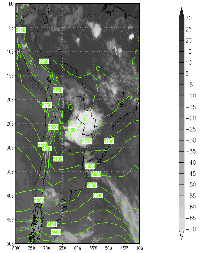
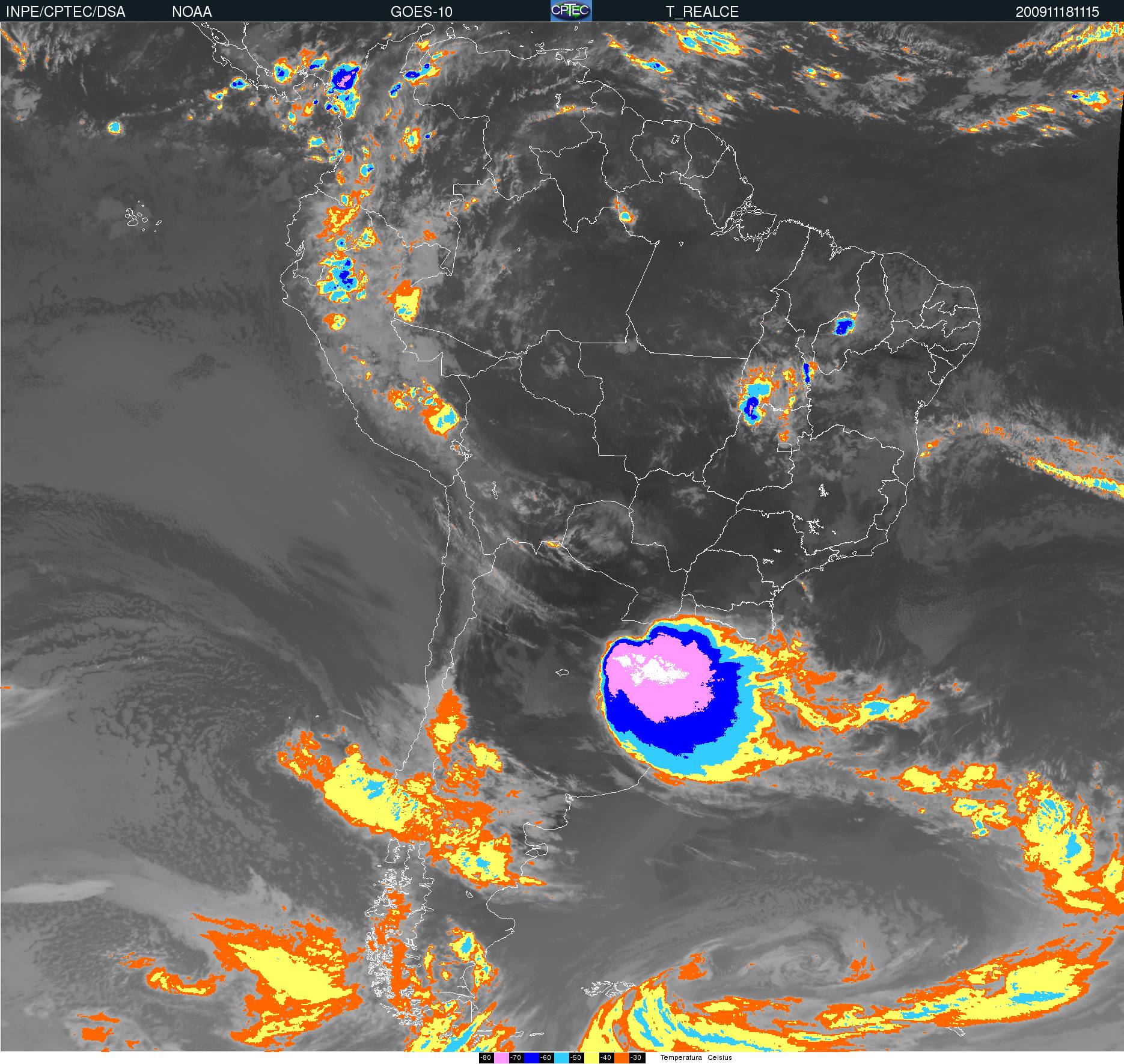
18 November 2009, 11:15 UTC - GOES 10 - Channel 4 (11.0 μm) Enhanced IR image.
|
|
|
|
18 November 2009, 11:15 UTC - GOES 10 - Channel 1 (0.65 μm) Visible image.
|
18 November 2009, 11:15 UTC - GOES 10 - Channel 5 (6.0 μm) WV image.
|
|
|
|
General Schematic MCC Top View
|
|
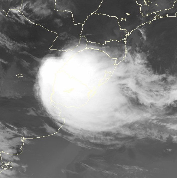
The loop shows the development of a MCC that took place from the night of 9 November until late afternoon on 10 November, 2008. During its initial stages, the development of the MCC is mainly caused by the presence of an intense LLJ. In its later stages, organized deep convection moves northward due to an approaching cold front.

|
Press "Play Button" for 9 November 2008, 14:21 UTC GOES 10 11.0 enhanced infrared loop image. 
|
MCC features using TRMM
Using the multiple-sensor satellite products of TRMM (Tropical Rainfall Measuring Mission), it is possible to analyze important features of convective systems. Due to the temporal resolution of TRMM, this product can be used for complementary diagnostic analysis, but not for operational use.
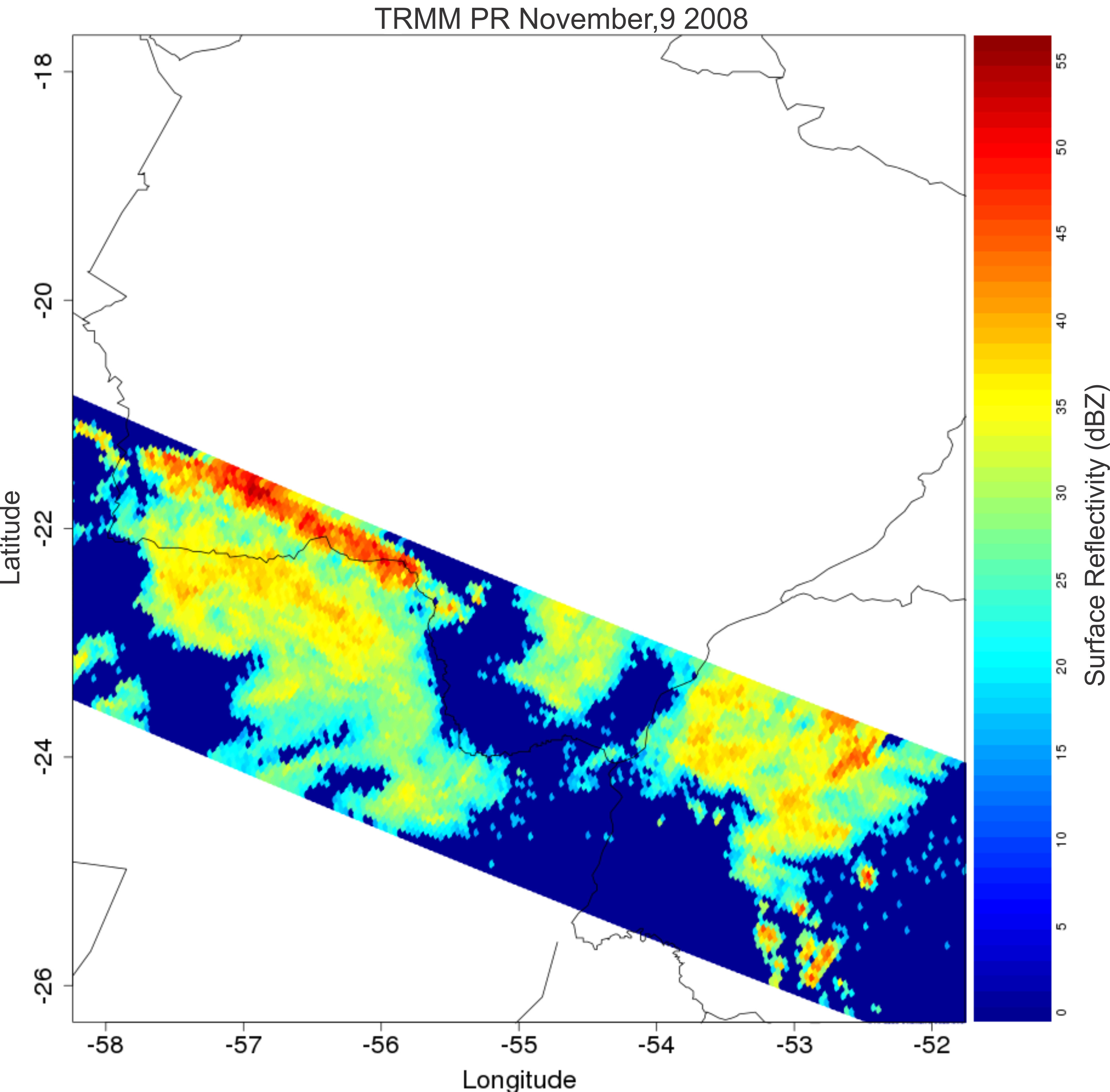
The following example is from a MCC that occurred on 9 November 2008 over northern Argentina and Paraguay.
An overpassing satellite detected a MCC in its dissipation stage. The MCC maturation occurred around 09:45 UTC and the satellite overpass over the area took place at 14:21 UTC. Nevertheless, intense convective activity was still present.
It is possible to analyze the reflectivity from the PR on board the TRMM. Reflectivity (designated by the letter Z) is the amount of transmitted power returning to the radar. It covers a wide range of signals. The dBZ values (decibels of Z) increase as the strength of the signal received by the radar increases.
The scale of dBZ values is related to the intensity of rainfall. Typically, dBZ values of 20 signify light rain, and the higher the dBZ, the stronger the rainfall.
Rain rates of 40 mm/h were observed over the northern part of the satellite swath. By analyzing surface reflectivity, cloud coverage and the presumed distribution of particles within the cloud, the cluster can be seen clearly. The cluster has reflectivity values ranging from 20 dBZ in the southern parts to 35 dBZ in the middle and 50 dBZ in the north.
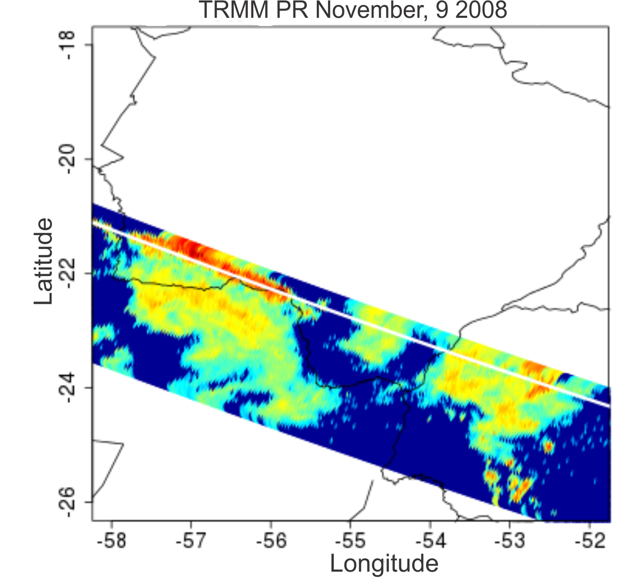
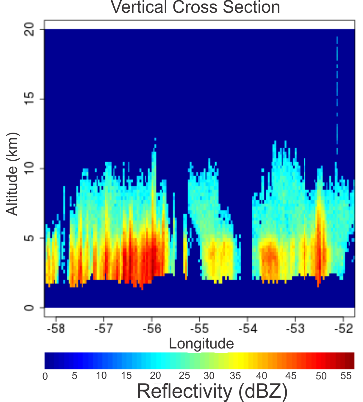
Of the next four images, the lower right image shows the vertical cross section along the white line drawn in the lower left image. From this vertical profile it can be seen that convection extends approximately from 2 km up to 10 km.
|
November, 9 2008 14:21 UTC - TRMM-PR - Surface rain rate (mm/h).
|
November, 9 2008 14:21 UTC - TRMM-PR - Surface reflectivity (dBZ).
|
|
|
|
November, 9 2008 14:21 UTC - TRMM-PR - White line indicates vertical cross section.
|
November, 9 2008 14:21 UTC - TRMM-PR - Vertical cross section of reflectivity (dBZ).
|
|
|
There are three distinct cells within the cluster. The cell on left has reflectivity values that reach 55 dBZ. The cell in the middle exhibits values of 35 dBZ, and the cell on the right has convection with values between 35 dBZ and 50 dBZ.
|
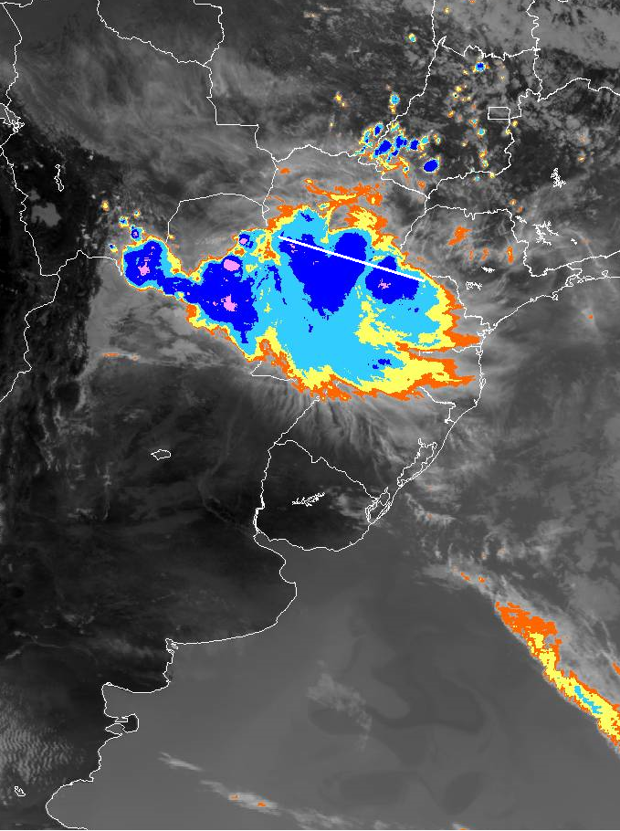
November, 9 2008 14:15 UTC - GOES-10 - Channel 4 (11.0 μm) Enhanced IR, white line indicates the vertical cross section.
|
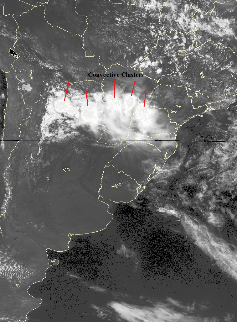
November, 9 2008 14:15 UTC - GOES-10 - Channel 1 (0.65 μm) Cloud clusters in the visible channel.
|
|
|
|
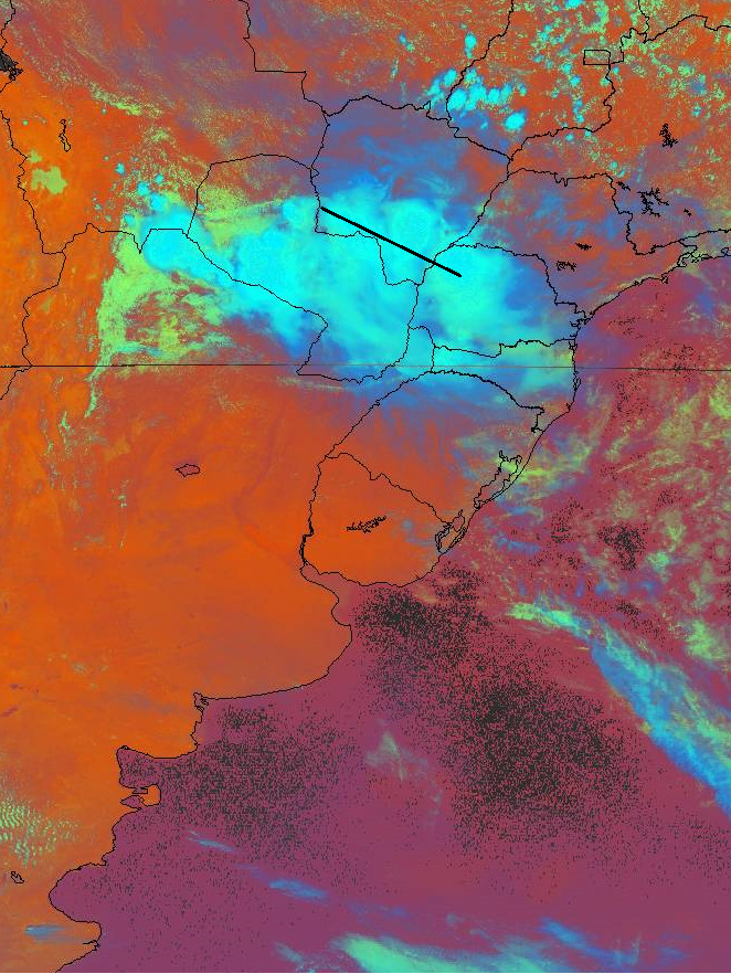
November, 9 2008 14:15 UTC - GOES-10 - RGB image, black line indicates the vertical cross section.
|
|
|
Meteorological Physical Background
Introduction
This conceptual model describes the MCC over Subtropical South America (SSA).
Mesoscale Convective Complexes (MCC) are a subset of Mesoscale Convective Systems (MCS). Seen from a satellite it is a large (100 km in at least one direction), roughly circular cloud shield. MCC may include squall lines, bow echoes and/or isolated convective cells, each of which have their own life cycles. Though isolated from one another, together they form a larger cloud system with an expanding cold pool and common cloud top shield (anvil).
The following table shows the criteria by which MCC are defined.
| Criteria | Features |
|---|---|
| Size: A | for the whole cloud shield (A): cloud top temperature <= -32°C, cloud shield area >= 100 000 km2 |
| Size: B | for the interior (B): cloud top temperature <= -52°C, cloud shield area >= 50 000 km° |
| Initiate | size definitions A and B are satisfied |
| Duration | size definitions A and B last at least 6 hours |
| Maximum extent | cloud shield satisfying temperature definition reaches ist maximum size |
| Shape | Eccentricity (minor axis/major axis) >= 0.7 at the phase of maximum size |
| Dissipation | size definitions A and B are no longer satisfied |
Broad Overview
MCC has typically four stages: initiation, development, mature stage and dissipation.
1. Initiation
This phase may include squall lines, bow echoes and isolated convective cells each having their own life cycle. Each system contributes to the expanding cold pool and anvil.
The following environmental features are favorable for MCC development:
- prominent baroclinic zones characterized by locally large values of lower tropospheric vertical wind shear and CAPE
- low-level jet oriented nearly perpendicular to the baroclinic zone
- pronounced warm advection and low-level winds with strong vertical veer
- local maximum of absolute humidity
- low-level convergence and upper-level divergence
- approaching weak mid-level trough with a weak vorticity maximum
- in most instances, an upper-level jet
- low-level warm temperature advection together with cyclonic vorticity advection increasing with height throughout the troposphere, causing maximum upward motion maximum at the mid-levels.
|
Initiation of a MCC: isolated convective cells near each other.
|
|
2. Development
Convergence of warm air and moisture in the lower levels feeds the convection process.
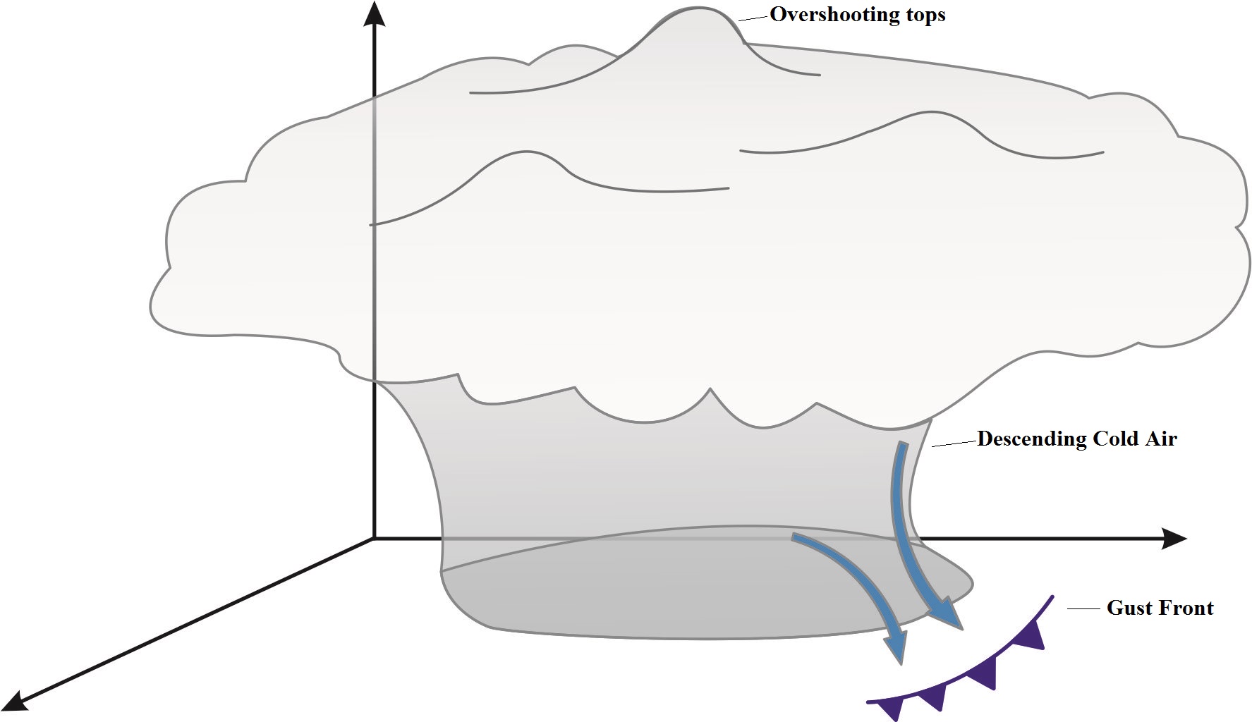
3. Mature stage
Convective elements continue to sustain the system's activity.
|
Mature stage of a MCC: nearly circular cluster of convective storms. Descending cold air creates gust fronts around the cluster, especially ahead of it.
|
|
4. Dissipation
Convection ceases.
|
|
Press "Play Button" for stages of MCC that occurred in 19th October 2009
Stages: Genesis (Initial Storms), Development, Mature and Dissipation |
Geographical Location
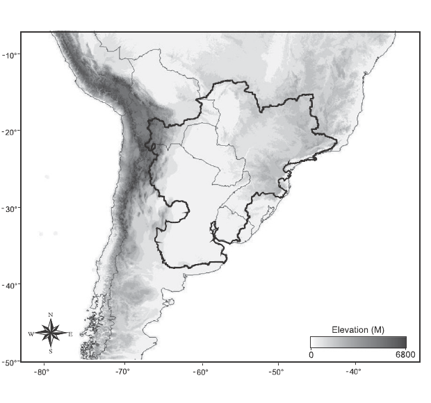
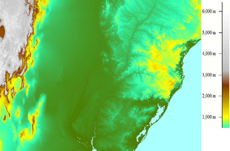
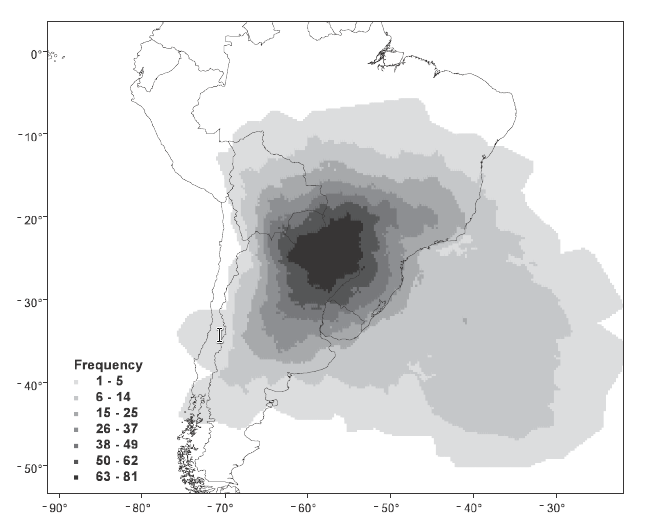
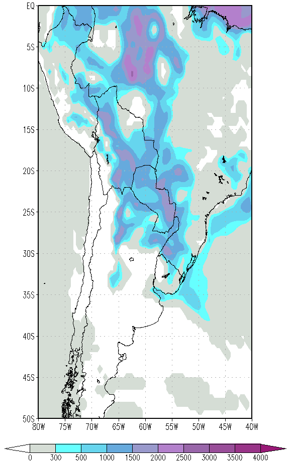
SSA consists of southern Bolivia, southern Brazil, Paraguay, northern Argentina, and Uruguay. It is home to the world's fifth largest river basin, the La Plata Basin (image on the left). Some of the world's most intense thunderstorm complexes (e.g. mesoscale convective complexes (MCC) and mesoscale convective systems (MCS) are found there. MCC precipitation measurements help to estimate the hydroclimate of the La Plata Basin. The MCC generally form around 20°S - 35°S and 70°W - 45°W.
|
Topographical map of SSA. The perimeter of the La Plata Basin is outlined.
|
Topographical map of the region where MCC's tend to form. Location between 20°S - 35°S and 70°W - 45°W.
|
|
|
Seasonal variety
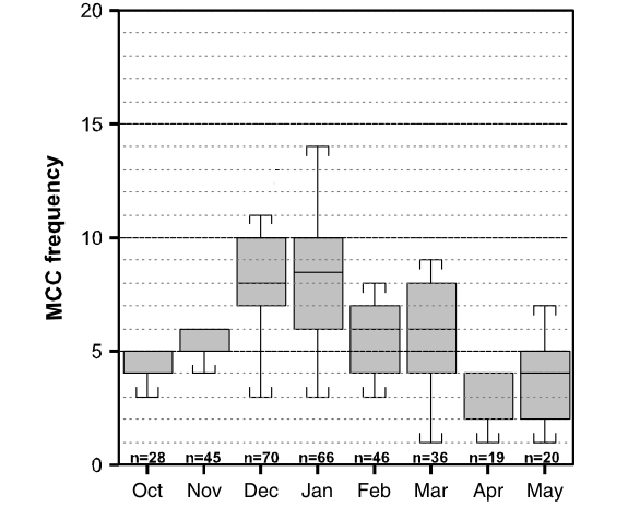
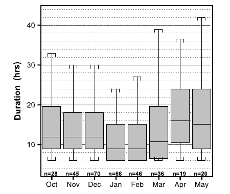
The images below provide MCC frequencies for the austral warm season (defined as October-May) for 1998-2007 by Durkee and Mote (2009). The image on the left shows that the highest frequencies occur in December and January. For the period in question, 70 events were recorded in December and 66 in January. The figure on the right depicts the areas of MCC occurence frequency. The gray shades represent the number of cases when grid points were located within a MCC storm track. Northeastern Argentina, Paraguay and southwestern Brazil are the regions with most observations of MCC.
|
Box-and-whisker plot of warm season MCC frequency by month for the years 1998-2007. The boxes show the interquartile range, the whiskers show the 10th and 90th percentiles and the solid line indicates the median. 'n' is equal to the number of events for a given month.
|
MCC frequency during the warm season (October-May) for 1998-2007 (N=330), determined by the number of cases when grid points were located within an MCC storm track.
|
|
|
Regional characteristics
MCC initiation generally occurs in the late afternoon or early evening. The systems reach maximum size around midnight before dissipating the next morning.
The average duration for all events was 14 h. The highest precipitation rates are most likely to occur between initiation and maximum extent, while the greatest amount of precipitation occurs near the maximum extent.
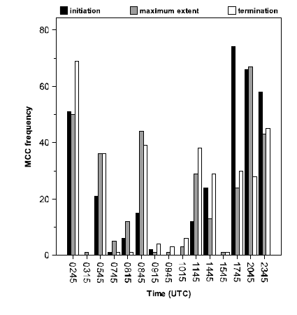
The greatest frequency of occurrence (nearly 75% of cases) for initiation, maximum extent, and termination were observed at 17:45, 20:45, and 02:45 UTC, respectively.
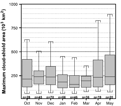
The average size of all 330 MCC at maximum extent was 256 500 km2 (by maximum cloud shield size). The largest MCC occurred in late spring, early summer and late fall, while the smallest systems occurred during late summer.
For the most part, the MCC ran their course (initiation, maximum extent and termination) inside 20°S - 30°S.
|
Frequency of MCCs during initiation, maximum size, and termination stages.
|
Frequency of maximum cloud top shield size.
|
|
|
|
MCC life cycle duration by month.
|
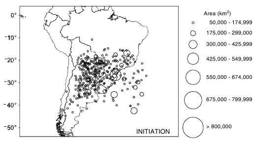
MCC cloud shields during the initiation stage, observed during the warm season months of October-May during 1998-2007.
|
|
|
|
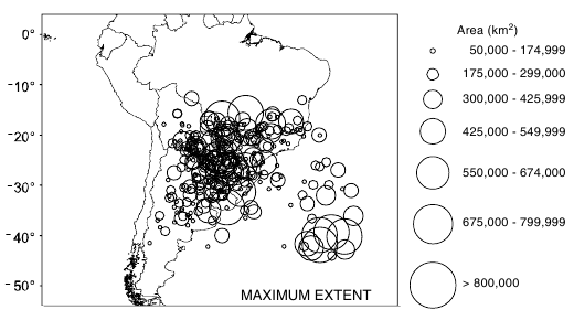
MCC cloud shields at maximum extent, observed during the warm season months of October-May during 1998-2007.
|
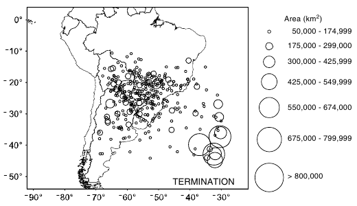
MCC cloud shields in the termination stage, observed during the warm season months of October-May during 1998-2007.
|
|
|
Key Parameters
|
|
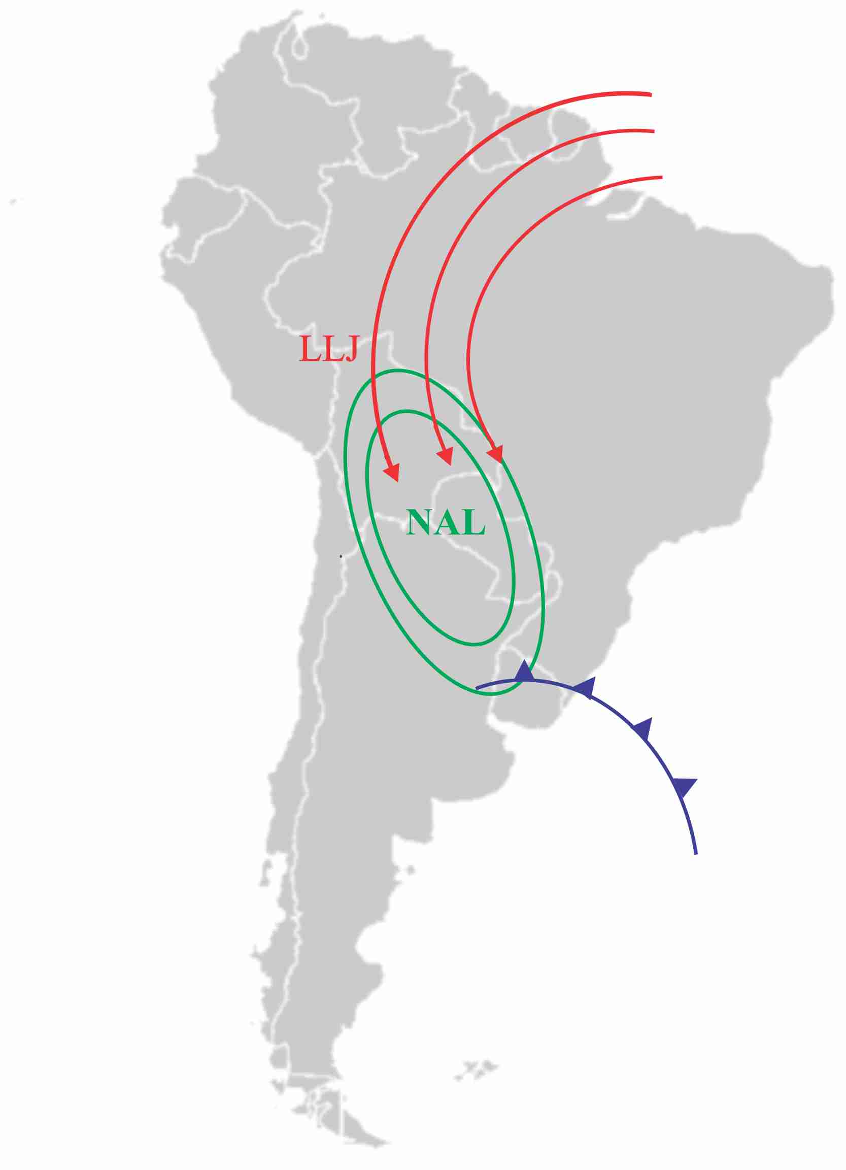
| Surface pressure and 850 hPa wind | |
|
Schematic of the synoptic situation for the formation and development of MCCs. Low-level jet (LLJ), Northeast Argentinan Low (NAL) and a cold front passing southern South America.
|
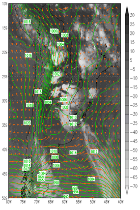
Mean sea level pressure (hPa) and wind 850 hPa (m/s) overlayed on a GOES 11.0 IR image on 9 November 2008 at 06:00 UTC
|
|
|
| Temperature Advection at 850hPa and Thickness (500hPa/1000hPa) | |
|
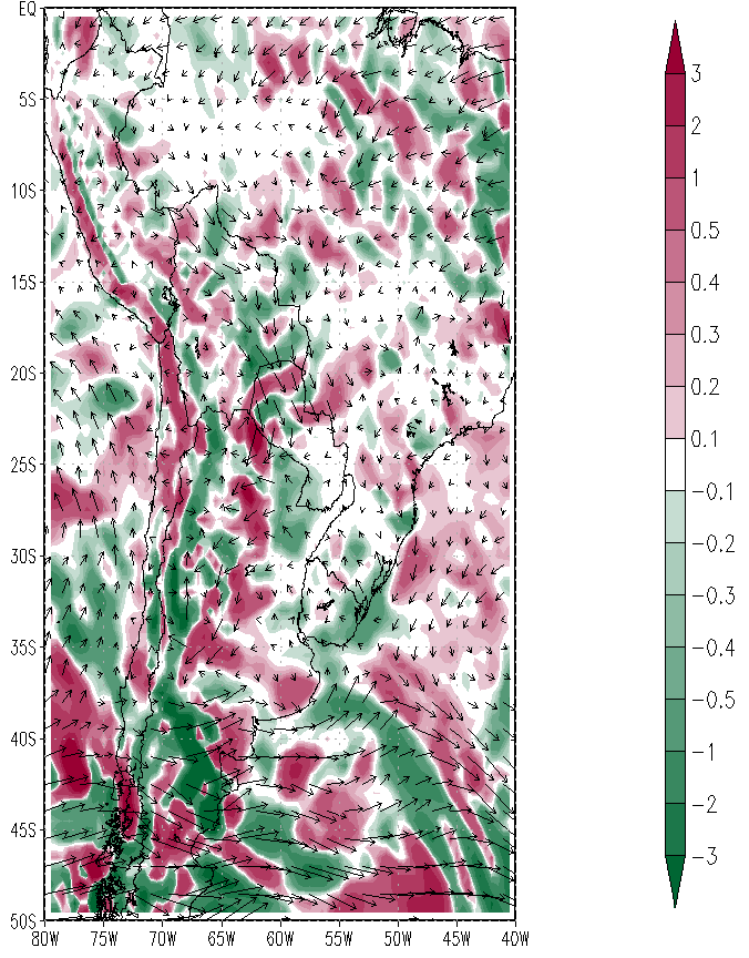
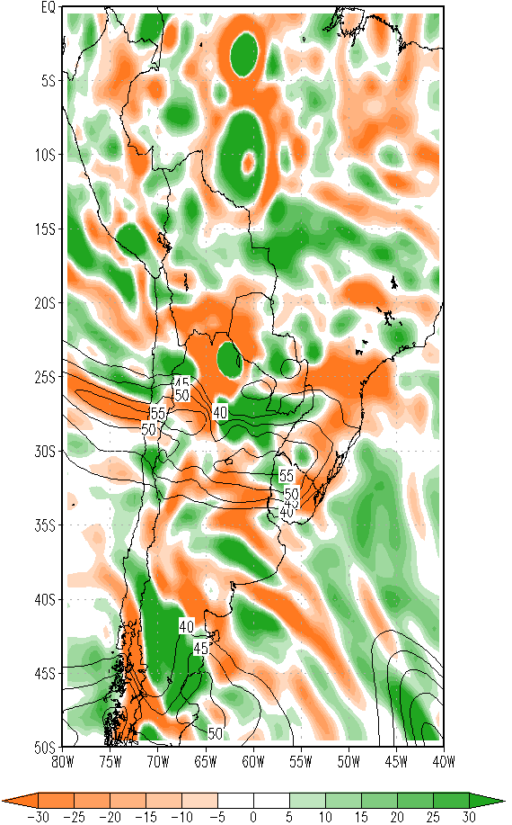
Temperature advection at 850 hPa (K/s) on 9 November 2008 at 06:00 UTC.
|
Thickness (500 hPa/1000 hPa) overlayed on a GOES 11.0 IR image on 9 November 2008 at 06:00 UTC.
|
|
|
| Convective Available Potential Energy and Enhanced IR channel | |
|
CAPE - Convective available potential energy (J/kg) on 9 November 2008 at 06:00 UTC.
|
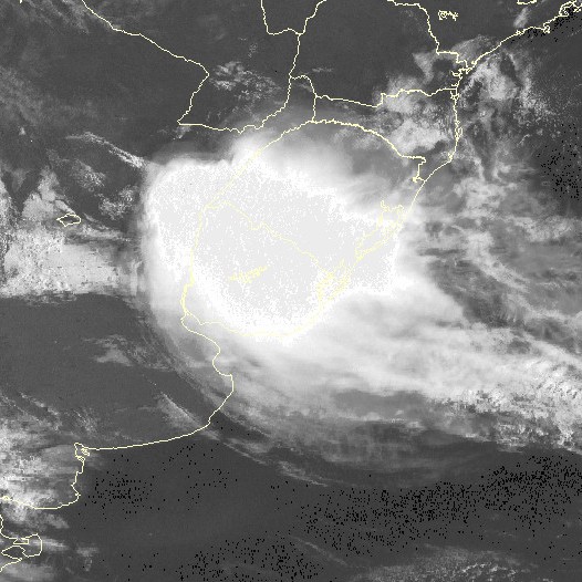
Enhanced infrared image from GOES 10 on 9 November 2008 at 06:00 UTC.
|
|
|
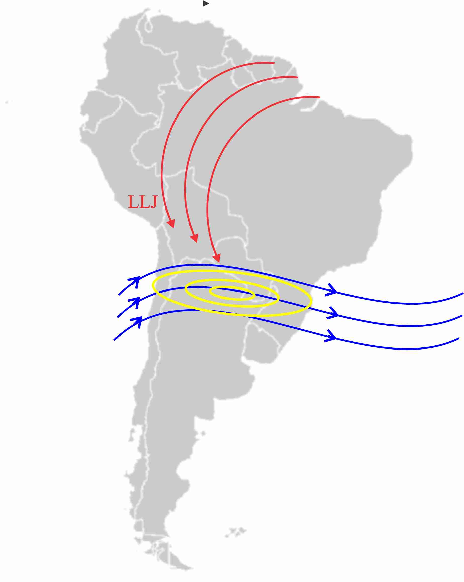
| Divergence and isotachs - 200hPa | Streamlines and isotachs at 200 hPa |
|
Divergence (10-5 s-1) and isotachs at 200 hPa.
|
Streamlines (blue) and isotachs (yellow) at 200 hPa, presented together with LLJ (red).
|
|
|
Typical Appearance In Vertical Cross Sections
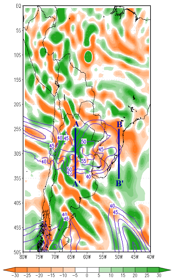
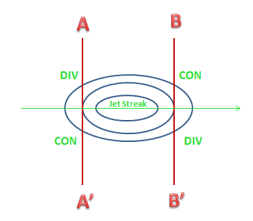
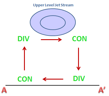
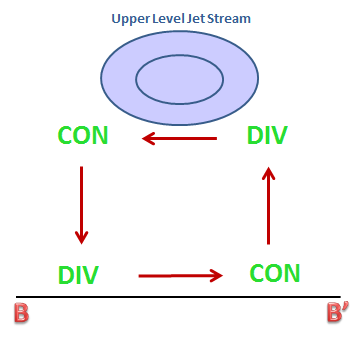
In MCC events, an upper-level jet stream decreases tropospheric stability and intensifies the formation of frontal systems. A dynamical connection between upper and lower levels operates trough vertical thermal circulations. The circulations can be analyzed using Riehl's model, which couples vertical velocities with meridional wind components.
|
Thermal Circulations markings overlayed at divergence field at 200hPa - November, 09th 2008 00UTC
|
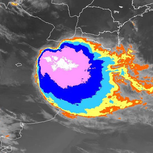
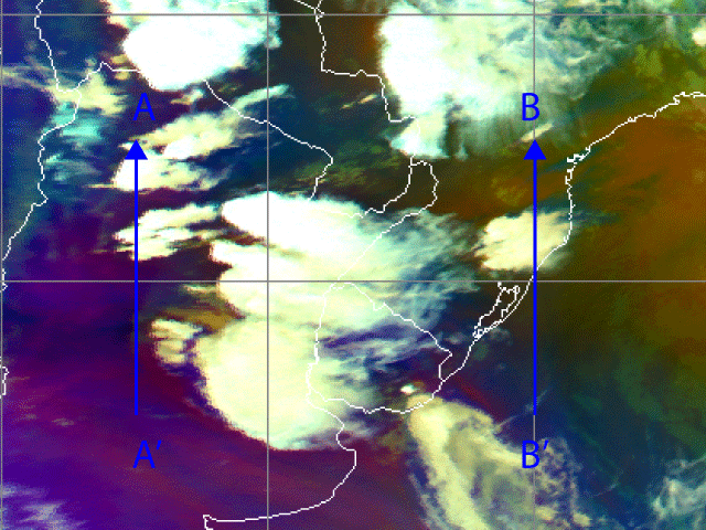
Meteosat-9 Airmass RGB Image 9 November 2008 / 00 UTC - the locations of the Cross Sections A-A' and B-B' are shown.
|
|
|
Locations of the thermal circulation cross sections at 200 hPa on 9 November 2008 at 00:00 UTC. AA': thermally direct circulation over 64°W, between 25°S and 35°S, BB': thermally indirect circulation over 50°W, between 25°S and 35°S.
|
Riehl's model for a high-level jet core and the locations of convergence and divergence accompanying it.
|
|
|
|
Thermally direct circulation accompanying a jet core.
|
Thermally indirect circulation accompanying a jet core.
|
|
|
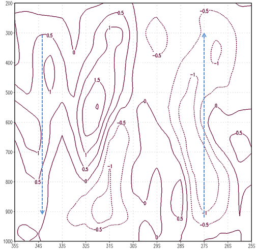
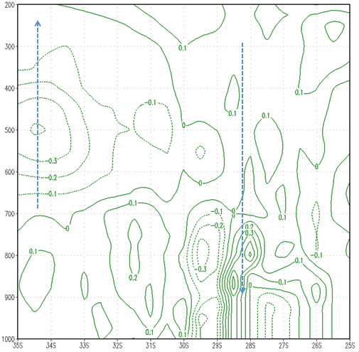
In the the cross section of vertical velocities along the line AA', there is descending air between 33°S and 35°S and ascending air between 22°S and 25°S (blue arrows). In the the cross section of meridional wind components along the line AA', the wind direction is mainly from south to north in the mid-troposphere (green arrow at 500 hPa), whereas the upper-level jet (green line at 250 hPa) and low-level jet (red line at 850 hPa) have an opposite direction.
|
Vertical velocity (Pa/s) across AA' along 64°W on 9 November 2008 at 00:00 UTC.
|
Meridional wind component (m/s) across AA' along 64°W on 9 November 2008 at 00:00 UTC.
|
|
|
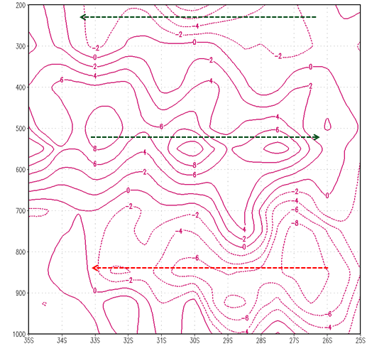
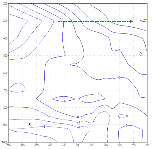
In the the cross section of vertical velocities along the line BB', there is ascending motion between 31°S and 35°S and descending motion between 22°S and 24°S (blue arrows). In this region the meridional wind components (green arrows) are not so strong as along AA', but a weak southerly component in the upper levels and a northerly component in the lower levels can be seen. The Upper Jet Stream couples the low and high level air streams through vertical circulations, which intensify the convective surface systems.
|
Vertical velocity (Pa/s) across BB' along 50°W on 9 November 2008 at 00:00 UTC.
|
Meridional wind (m/s) across BB' along 50°W on 9 November 2008 at 00:00 UTC.
|
|
|
Weather Events
Important weather events is associated with MCC events. The mean weather events associated with this systems are heavy precipitation, hail, strong gust fronts, lightning and, in some cases, tornadoes
| Parameter | Description |
|---|---|
| Precipitation |
|
| Temperature |
|
| Wind (incl. gusts) |
|
| Other relevant information |
|
|
|
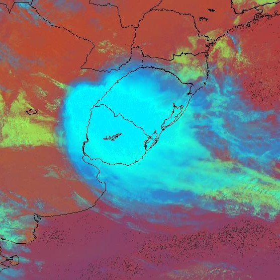
Enhanced IR on 18 November 2009 at 11:15 UTC.
|
|
|
References
- DURKEE, J; Mote, T; Shepered, J. M.: The Contribution of Mesoscale Convective Complexes to Rainfall across Subtropical South America. International Journal of Climatology, in press, 2009.
- DURKEE, J. D., and T. L. Mote, A climatology of warm-season mesoscale convective complexes in subtropical South America. Int. J. Climatol., doi:10.1002/joc.1961, in press, 2009.
- HOUZE, R.A.Jr., Mesoscale Convective Systems. Reviews of Geophysical 42RG4003, 2004.
- LAING, A. G., and J. M. Fritsch, The large-scale environments of the global populations of mesoscale convective complexes. Mon. Wea. Rev., 128, 2756-2776, 2000.
- MADDOX, R. A.: Mesoscale Convective Complexes. Bulletin of the American Meteorological Society, p. 1374-1387, 1980.
- MADDOX, R. A.: Large-scale Meteorological Conditions Associated with Midlatitude, Mesoscale Convective Complexes. Monthly Weather Review, v. 111, p. 1475-1493, 1983.
- SALIO P, Nicolini M, Zipser EJ. 2007. Mesoscale convective systems over southeastern South America and their relationship with the South American low-level jet. Monthly Weather Review 135:1290-1309.
- VELASCO, I.; Fritsch, J. M.: Mesoscale convective complexes in the Americas. Journal of Geophysical Research, v. 92, p. 9591-9613, 1987.