Ice and saline lakes colour in Cloud Phase RGB and Cloud Type RGB
On 11 May at around 18 UTC a weak ridge over the western South America produced clear skies over most of the Andes and the Atacama Desert, resulting in a clear view of the landscape, lakes, plains, etc.
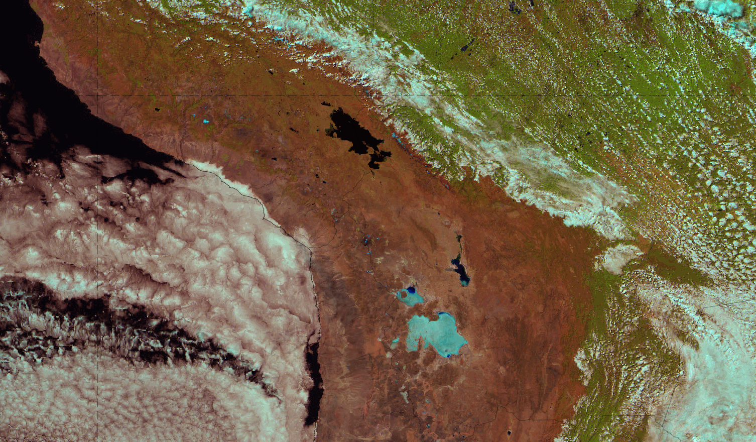
On the first image, Natural Colour RGB, one can see shallow convection over the Amazon rainforest where a cumulus field and some stratocumuli spread across the big green background. To the west a very dry air mass, with no embedded cloudiness, where the clear brown colour of the mountains and the desert is visible. Over the sea the cold Humboldt Current creates the stratocumulus field that covers most of the sea and small parts of the coast.
Figure 1: GOES 16 Natural Color RGB image of the Andes and the Atacama Desert on 11 May 2020, 18 UTC
A number of features in this dry, very clear air mass are interesting to look at, especially in the Cloud Phase RGB and in the Cloud Type RGB products, available from GOES. First let's see what is there in the Natural Colour RGB (figure 2)
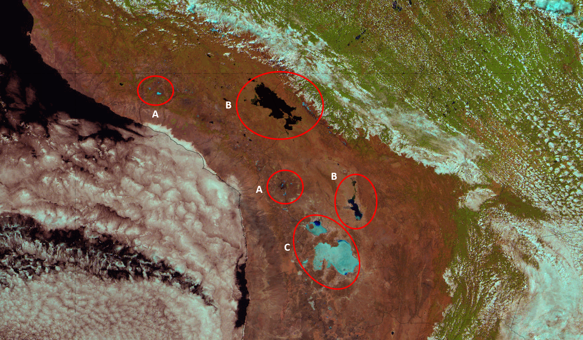
Figure 2: Natural Colour RGB image on 11 May 2020, 18 UTC - markings depicting main points of interest
Natural Colour RGB:
R: NIR 1.6 μm
G: VIS 0.8 μm
B: VIS 0.6 μm
The A markings show patches of snow on tops of the mountains, which is basically ice that reflects little in the NIR 1.6 micrometer channel therefore it is cyan. The B markings depict two big lakes of the region: Lake Titicaca, one in the north and Lake Poopó. Titicaca is a regular freshwater lake high up in the mountains, whereas Lake Poopó is a very shallow saline lake and in its southern part, you can see a saline plain in a cyan shade.
A bit to the southwest two salt plains can be observed, the Coipasa lake and the associated salt plain and the huge Salar de Uyuni salt plain (marking C). The salt plains here and around the world also have similar colours as the thick cirrus clouds or the snow on the ground, due to low reflection in the 1.6 micrometer channel.
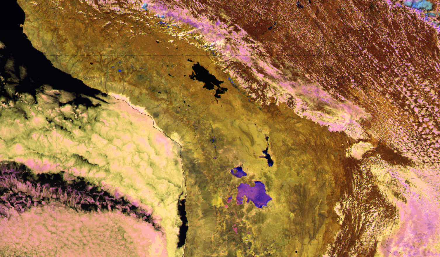
Figure 3: GOES 16 Cloud Phase RGB image of the Andes and Atacama
Cloud Phase RGB:
R: NIR 1.6 μm
G: NIR 2.25 μm
B: VIS 0.6 μm
In the Cloud Phase RGB the saline plains have a color similar to water clouds with big water droplets. The beams important for producing such colors are, in order of intensity, blue and red, while the green one is almost negligible. This means the salt reflects best in the visible region, while the NIR 1.6 micrometer channel gives only a hint of its brightness so the salt (purple) can be distinguished from the snow (strong blue).
Also a change in the salt property can be observed in the Salar de Uyuni salt plain, going from east to west, where the purple color significantly changes its shade.
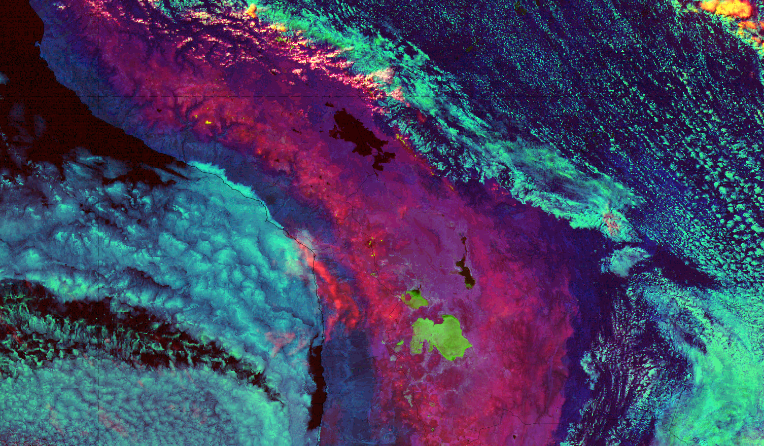
Figure 4: GOES 16 Cloud Type RGB image of the mountains and the desert
Cloud Type RGB:
R: NIR 1.38 μm
G: VIS 0.6 μm
B: NIR 1.6 μm
In the Cloud Type RGB one thing is certain, lakes and seas are always very dark or black in combinations of VIS and NIR channels. The salt plains are green, because of the big impact in the 0.6 micrometer channel as in the Cloud Phase RGB. The snow patches on the mountain tops are yellow here as is the ice in compact high clouds.
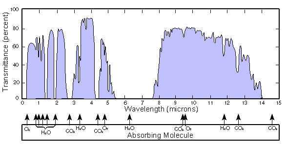
The 1.6 micrometer channel gives nice bluish (marine) colours to the lower clouds over the Amazonian rainforest and over the Pacific. The 1.38 μm channel detects only the highest clouds due to a strong water vapour absorption (see figure 5) occurring already in the higher troposphere.
Figure 5: The dependency of transmittance of radiation on different absorbing molecules - basically no transmittance around 1.4 micrometers - very strong absorption by water molecules
Quiz:
Now, look at the two images in the slider below, North America on 15 April 2020 at 18 UTC:
|
|
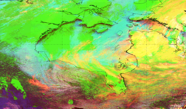
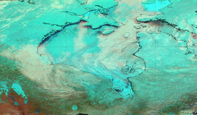
Figure 6: Cloud Type RGB and Natural Colour RGB over Northern US and Canada, 15 April 2020 at 18 UTC
Note: for bigger images click
here
Intuitively, what is the difference between this air mass and the air mass over the Andes where we could've seen the snow in yellow colour?
In general, how does the humidity change with altitude?
Why are the snow and the sea ice depicted in green colour here?
Feedback: The air over the Andes is dry because of height and because of its geographical location (the Atacama Desert being the driest place on Earth located right next to them), thus much drier than the air over North America. The 1.38 μm channel is located in a strong water absorption band so it is strongly affected by any small amount of water vapour.
Due to this dryness, the snow on the Andes appears yellow because even the (red) 1.38 μm band radiation reaches the ground and manages to get back to the satellite and then in combination with the (green) 0.6 μm channel gives a yellow colour. The 1.6 μm band is strongly absorbed by the ice crystals and therefore is not significantly contributing to the resulting colour.
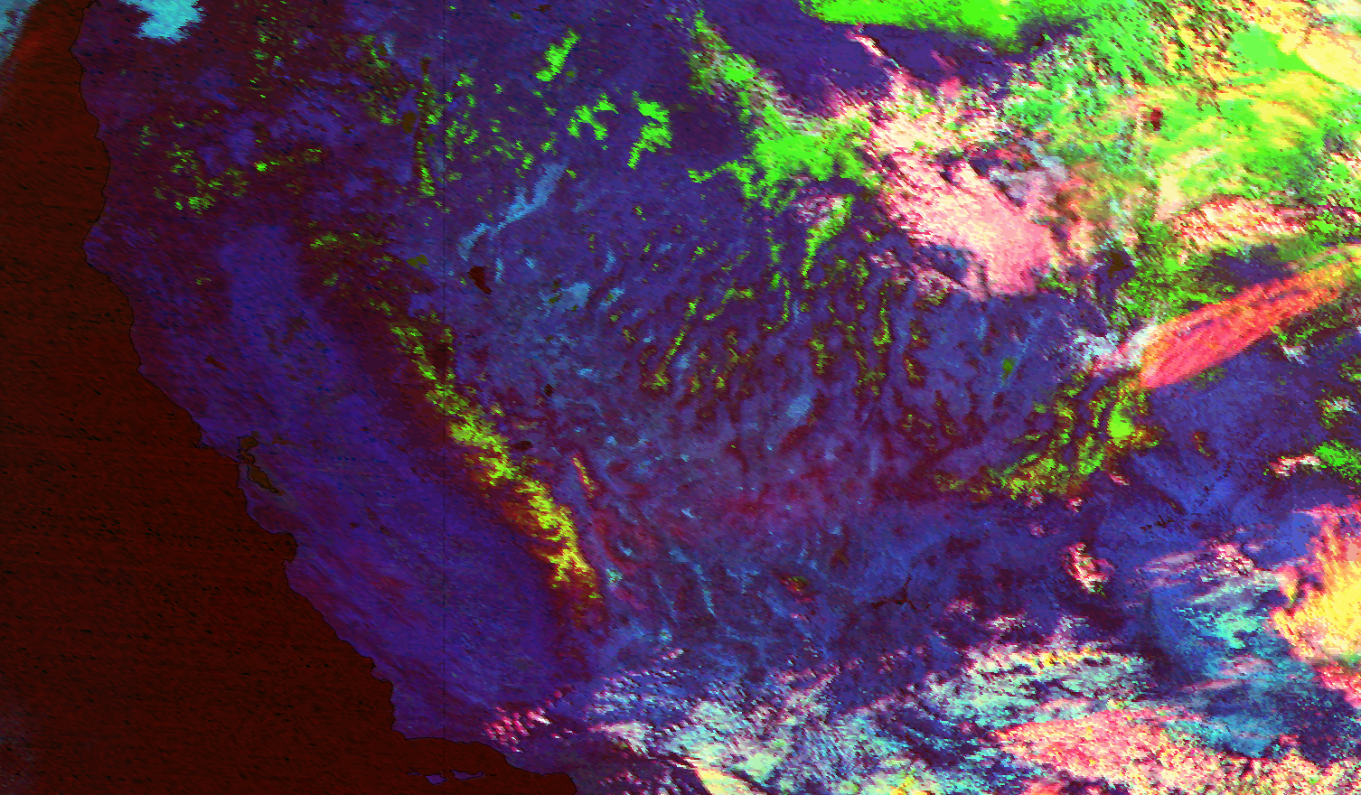
The yellow snow phenomenon in the Cloud Type RGB can also appear in other areas of high mountains around the world, like the Alps, Himalayas, etc., due to dry air aloft. An example is shown on image 6 taken over the west of US, where a change in colour of the snow on the mountains is evident.
Figure 7: Cloud Type RGB over the US, 10 February 2020, 21 UTC
