Comparison with other RGBs
Cloud Type and Dust RGBs
The Cloud Type RGB is sensitive to high-level thin ice clouds. There are other RGBs that are also sensitive to high-level thin ice clouds. These use the (IR12.0-IR10.8) channel difference in their red component: the Dust RGB, 24h Microphysics RGB (a variant of Dust RGB) and Night Microphysics RGB. The Cloud Type RGB is created from solar channels, while the Dust, 24h Microphysics and the Night Microphysics RGBs are created from infrared channels.
In Fig. 6.1 VIIRS Cloud Type and Dust RGBs are compared in terms of detecting thin cirrus. Both detect cirrus clouds and the thin parts of the anvils of mature convective clouds. In this scene, these are mainly above land, not above lower-layer clouds. The detection efficiency here seems to be about the same. (In the Dust RGB thin cirrus clouds above cloud-free areas appear black or dark blue, and in the Cloud Type RGB thin cirrus clouds above cloud-free areas appear red or dark red.)
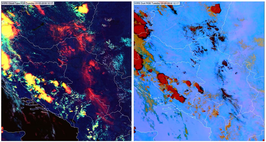
Fig. 6.1: VIIRS Cloud Type RGB (left) and Dust RGB (right) taken on 29 May 2018 at 12:17 UTC. (Credit to NOAA)
The Cloud Type and the Dust RGB complement each other in detecting thin cirrus. They work in different ways: the primary difference is that the Dust RGB detects thin clouds, while the Cloud Type RGB detects high clouds. The Dust RGB can detect a contrail even above a thick high cloud, whereas the Cloud Type RGB cannot. Fig. 6.2 shows a case when contrails are present above lower-level clouds. Contrails are much better seen in the Dust RGB: see the dark lines in the right panel.
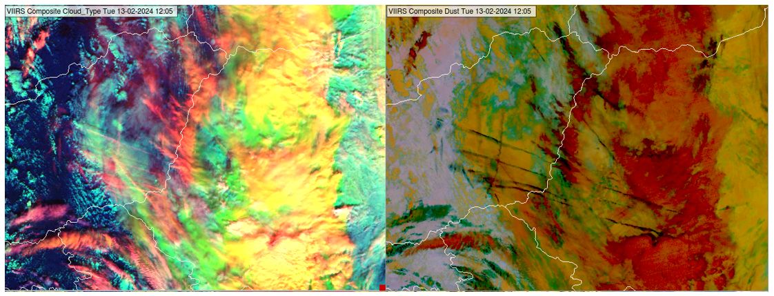
Fig. 6.2: VIIRS Cloud Type RGB (left) and Dust RGB (right) taken on 13 February 2024 at 12:05 UTC. (Credit to NOAA)
Note that the Cloud Type RGB can see high-level (thick or thin) aerosol plumes even with small particles, like smoke; the Dust RGB usually cannot see them due to the much longer wavelengths.
Cloud Type and Cloud Phase RGBs: thin cirrus cloud detection
The Cloud Type RGB is much more sensitive to high-level thin ice clouds than the Cloud Phase RGB. Fig. 6.3 shows a comparison of VIIRS Cloud Type and Cloud Phase RGBs. Thin cirrus clouds appearing red in the Cloud Type RGB are hardly seen in the Cloud Phase RGB.
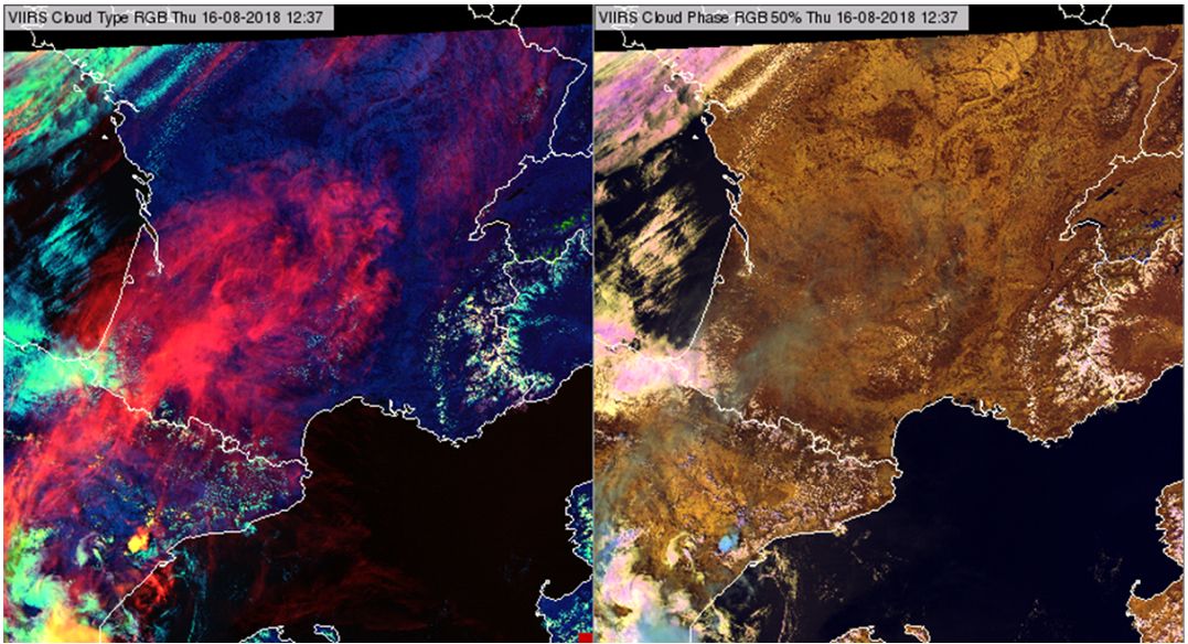
Fig. 6.3: VIIRS Cloud Type RGB (left) and Cloud Phase RGB (right) from 16 August 2018, 11:37 UTC. (Credit to NOAA)
Cloud Type and Cloud Phase RGBs: atmospheric water vapour amount and cloud top height information
The Cloud Type RGB (through its red component) may provide a hint of the presence of dry airmasses. The colour of low- and mid-level water clouds turn from cyan to whitish/pinkish if the vertically integrated water vapour amount above their tops is small. In a Cloud Type RGB image there might be some regions where the water clouds appear cyan and other regions where they appear whitish/pinkish. In this way the Cloud Type RGB depicts something that is not depicted by other RGBs, for example by the Cloud Phase RGB, see Fig. 6.4.
With a very dry atmosphere, NIR1.3 can sometimes even detect low clouds; examples are shown in Figs. 6.4 and 6.5. In Fig. 6.4 cloud streets are seen above Ukraine. The small cumulus clouds just forming are low, and appear cyan. Further on when they become somewhat higher, they appear whitish/pinkish. The whitish/pinkish colour indicates that the atmospheric moisture amount aloft is small. The ECMWF 12:00 UTC analysis of Total Column Water Vapour confirms that this area is very dry and the radiosonde profile shows that the whole profile is dry. The NWCSAF Cloud Type product (retrieved from SEVIRI data, not shown) classifies these clouds as low clouds. Above the Black Sea an elongated cloud band appears cyan in the Cloud Type RGB (even though it is higher according to the Cloud Type product). ECMWF shows a moister band here.
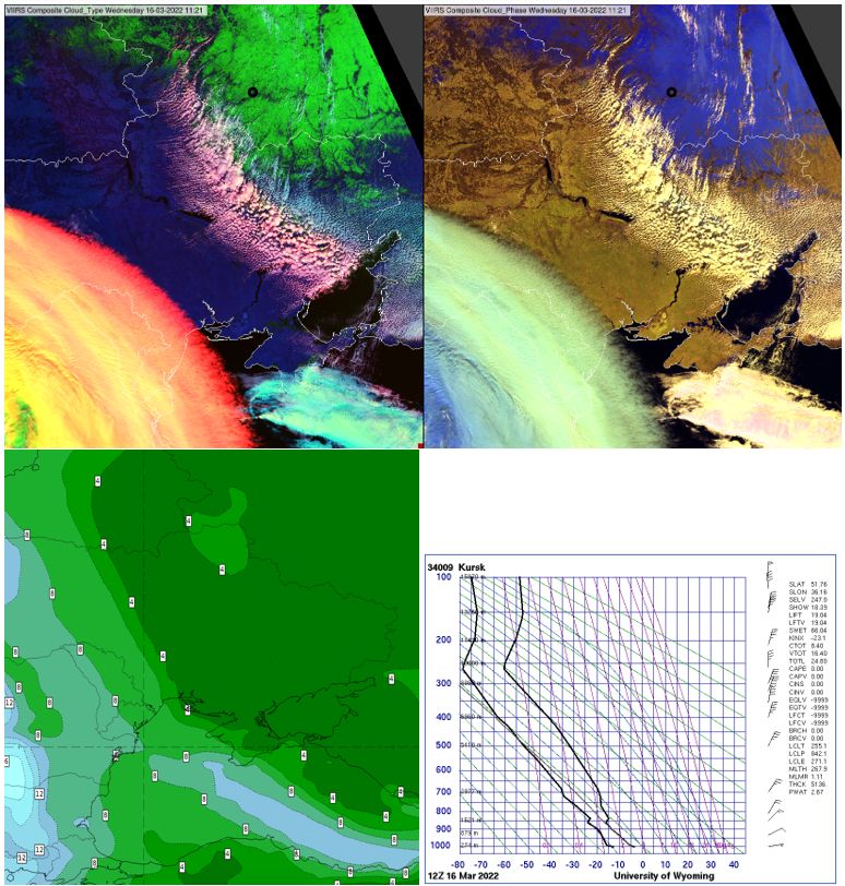
Fig. 6.4: VIIRS Cloud Type RGB (upper left), Cloud Phase RGB (upper right) taken on 16 March 2022 11:10 UTC, 12:00 UTC analysis of ECWWF Total Column Water Vapour (bottom left), radiosonde profile measured in Kursk (Russia) at 12 UTC (bottom right). The black rings in the RGB images indicate the location of the Kursk radiosonde station. (Credit to NOAA, ECMWF and University of Wyoming)
Fig. 6.5 shows an example where multilayer water clouds were present (see the clouds indicated by the arrows). The lower-layer water clouds are not detected by NIR1.3 (appearing cyan in the Cloud Type RGB), but NIR1.3 detects the thin water patches above them (appearing pinkish). The two different colours help to identify that multilayer water clouds were present. This information is not seen in the Cloud Phase RGB. The radiosonde profile measured at Velikie Luki confirms that the atmosphere was extremely dry. The location of the radiosonde station is indicated by the black circle in the RGB images.
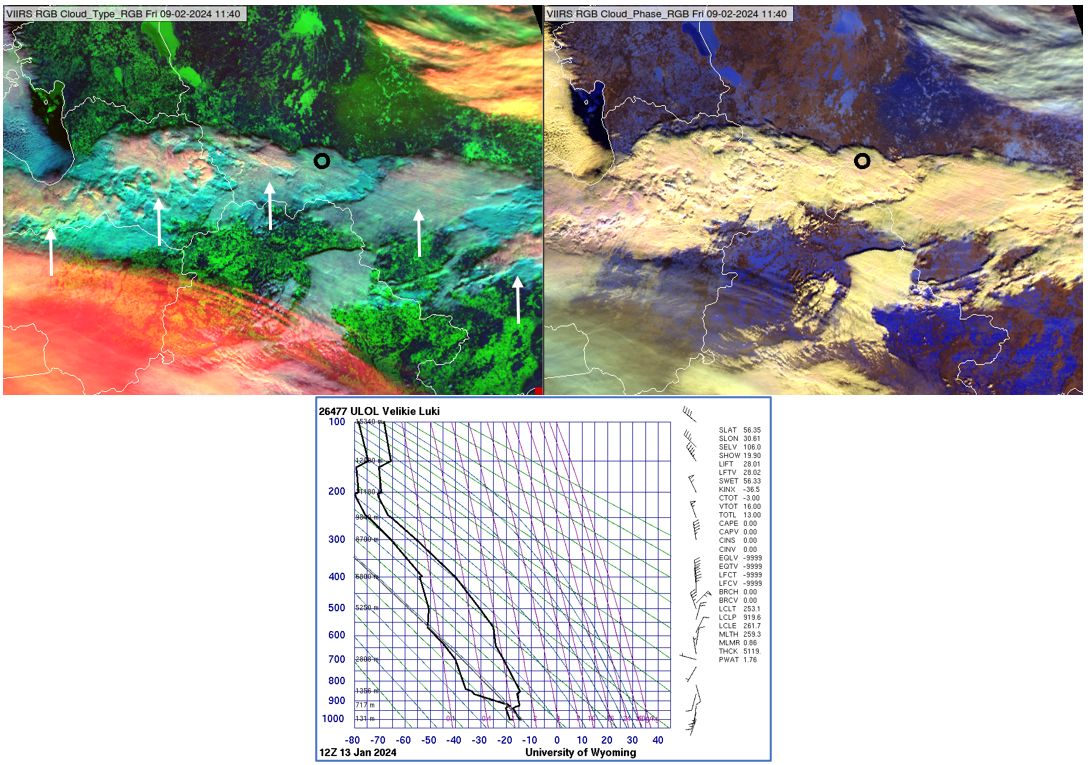
Fig. 6.5: VIIRS Cloud Type RGB (upper left), Cloud Phase RGB (upper right) taken on 09 February 2024 at 11:40 UTC, radiosonde profile measured in Velikie Luki (Russia) at 12:00 UTC (bottom). The black circles in the upper panels indicate the location of the radiosonde station. (Credit to NOAA and University of Wyoming)
Cloud Type and Cloud Phase RGBs: cloud top microphysics
The Cloud Phase RGB provides reliable information about the cloud top phase and particle size of thick clouds. The Cloud Type RGB is not so good at this; although it provides some cloud phase information, it is better at identifying the cloud height. Figs. 4.7 and 4.8 show examples.
Fig. 6.6 shows deep convective clouds in Cloud Type and Cloud Phase RGBs. While in the Cloud Phase RGBs, areas of smaller and larger cloud top particle sizes above thick ice clouds can be distinguished (lighter and darker blue shades), this is not possible in the Cloud Type RGB. (The red component is so strong and oversaturated due to strong enhancement that it usually suppresses the weak cloud top particle size information from the blue component).
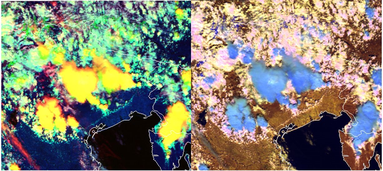
Fig. 6.6: VIIRS Cloud Type (left) and Cloud Phase (right) RGBs from 13 May 2018, 12:17 UTC. (Credit to NOAA)
Cloud Type RGB and 24h Microphysics RGB
In cloud-free areas in the 24h Microphysics RGB, darker blue shades indicate larger vertically integrated water vapour amounts (the same applies to the Dust RGB), while lighter blue shades indicate smaller water vapour amounts. In the Cloud Type RGB, whitish water cloud means that the moisture content above the cloud tops is small. The 24h Microphysics RGB depicts the moisture content in the shade of cloud-free region, and the Cloud Type RGB in the colour of the water clouds. In the Fig. 6.7 the whitish clouds (higher/larger cumulus clouds) indicated by arrows in the Cloud Type RGB are located in the lighter blue area in the 24h Microphysics RGB. The two RGBs harmonize.
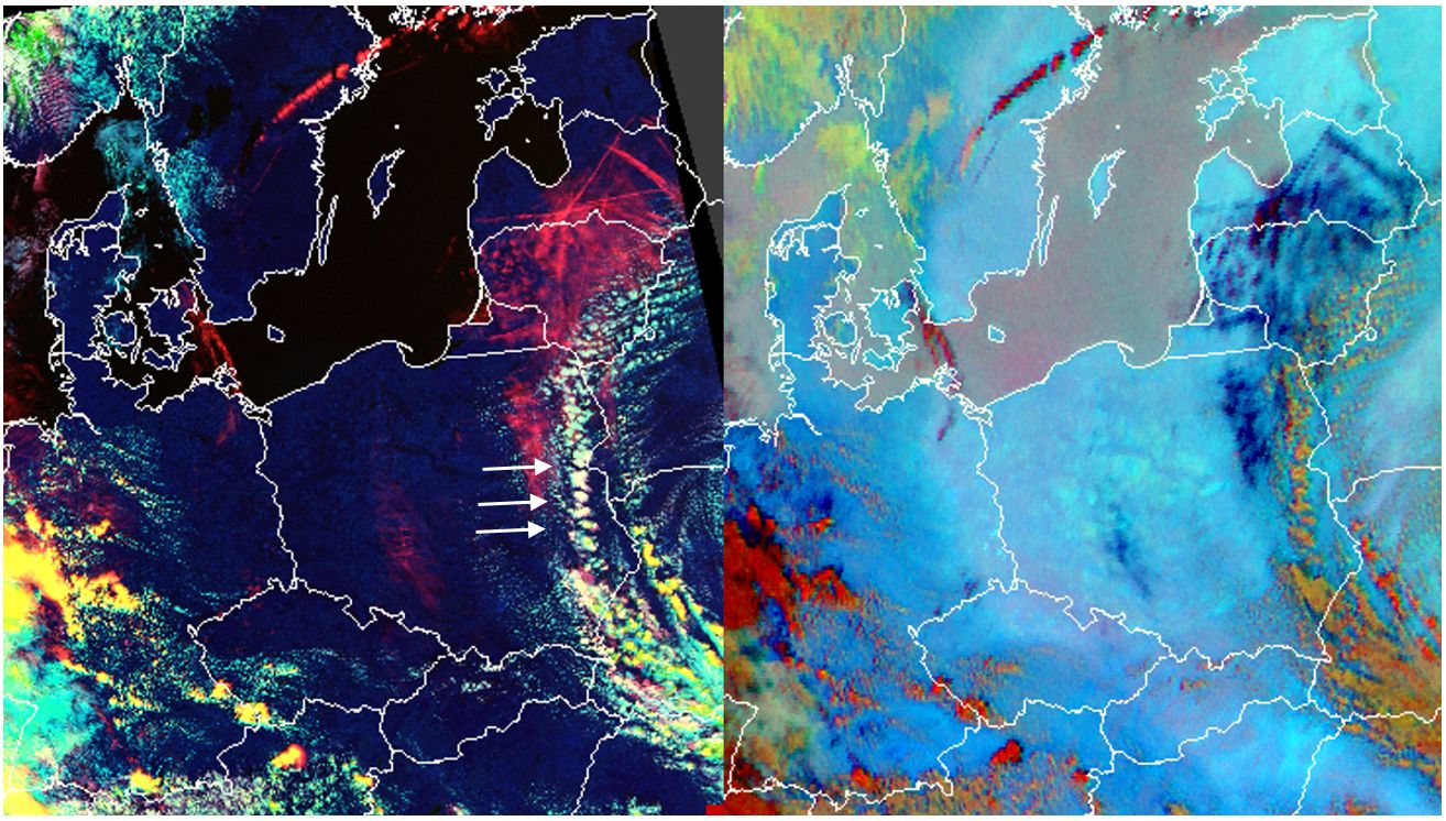
Fig. 6.7: VIIRS Cloud Type RGB (left) and SEVIRI 24h Microphysics RGB (right) taken on 13 May 2018 at 12:17 UTC. (Credit to NOAA)