Benefits and limitations
Benefits
- It is sensitive to very thin cirrus clouds. It complements infrared-based thin cirrus detection.
- It is sensitive to higher-level thin aerosol plumes.
- Vivid colours.
- Good colour contrast between several features.
- It combines cloud phase, cloud optical thickness and cloud height information.
- It distinguishes lower and higher clouds.
- It distinguishes lower and higher aerosol plumes if they are recognizable.
- It may provide hints of the existence of dry airmasses if:
- The low/mid-level water clouds appear whitish or pinkish instead of cyan. In this case the vertically integrated water vapour amount above the cloud top is small.
- The elevated snow-free terrain has a reddish tone instead of dark blue.
- The elevated snowy terrain appears yellow instead of green.
- Coastlines and surface features are visible.
- It complements other RGB types. For example, the Cloud Phase RGB separates the thick water from thick ice clouds, while the Cloud Type RGB separates lower clouds from higher clouds.
- It mostly works well for cloud type classification in a not very dry atmosphere. The colours of the following features are (most often) different, (although thin cirrus above lower-level clouds or snowy land may cause problems even in moist atmospheres):
- (snow-free) surface,
- low/mid clouds,
- high clouds.
Limitations
- Limited to daytime applications.
- Cloud height information is indirect: it depends on the vertically integrated water vapour amount above the cloud top and the viewing geometry. Consequently, the height limit between “higher” and “lower” clouds varies spatially and temporally and it varies over a broad interval.
- The phase identification is sometimes problematic, for example:
- The colour contrast between thick mid-level ice clouds and thick water clouds consisting of large droplets is low in moist atmospheres.
- The colour contrast is low between thin high-level ice clouds above a surface (red) and thin water clouds with little water vapour aloft (pinkish). It is important to differentiate red and pink phenomena in order to avoid false cirrus detection.
- High-level lee clouds with extremely small ice crystals appear pink, similarly to thin water clouds with little water vapour aloft
- The cloud type differentiation is sometimes problematic:
- The coupling between cloud (surface) classes and colours is ambiguous. Different cloud types may appear the same colour. The same cloud type may appear in different colours.
- The height information depends on time and location, and it can vary significantly.
- The phase information is not perfect.
- The colour contrast is usually low between snow and mid-level ice clouds.
- Thin cirrus clouds above thick high clouds (like contrails) are not recognizable.
- Cloud top features are usually not seen due to saturation of the reflected NIR1.38 signal (e.g., overshooting tops, gravity waves, above anvil cirrus plumes)
Warning
- Do not oversimplify the interpretation!
- Not every thin high ice cloud is red.
- Not all reddish phenomena are thin high-level ice clouds.
Fig. 5.1. shows an FCI case (created from preliminary commissioning data). The red/yellow cloud in the Cloud Type RGB is a high-level ice cloud. The encircled whitish/pinkish cloud is a mid-level water cloud; see the Cloud Phase RGB for phase identification and the Airmass RGB and WV6.3 images for height identification. Although the encircled cloud differs from the surrounding red/yellow cloud both in phase and height, unfortunately the colour contrast between them is low. This is one example of a Cloud Type RGB limitation: low colour contrast between thin mid-level water clouds (if the water vapour amount is small aloft) and thin high-level ice clouds.
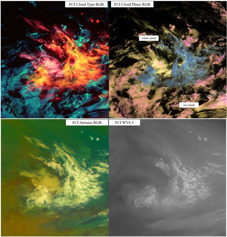
Fig. 5.1: MTG FCI Cloud Type RGB (upper left), Cloud Phase RGB (upper right), Airmass RGB (bottom left) and WV6.3 image (bottom right) taken on 13 January 2024 at 11:50 UTC. Images created from preliminary commissioning data. (Credit to EUMETSAT).