The Cut-Off Stage
In the cut-off stage, the ULL is separated from the ribbon of westerly winds and lies south of the polar front in the northern hemisphere (see Figure 1). The ULL in the cut-off stage is a cold pool of air surrounded by warmer air masses and characterized by a closed circulation at higher levels. Propagation speed and direction are not determined by the main belt of westerlies anymore; in fact, at this stage the ULL may even move against the background flow making it a retrograde system.
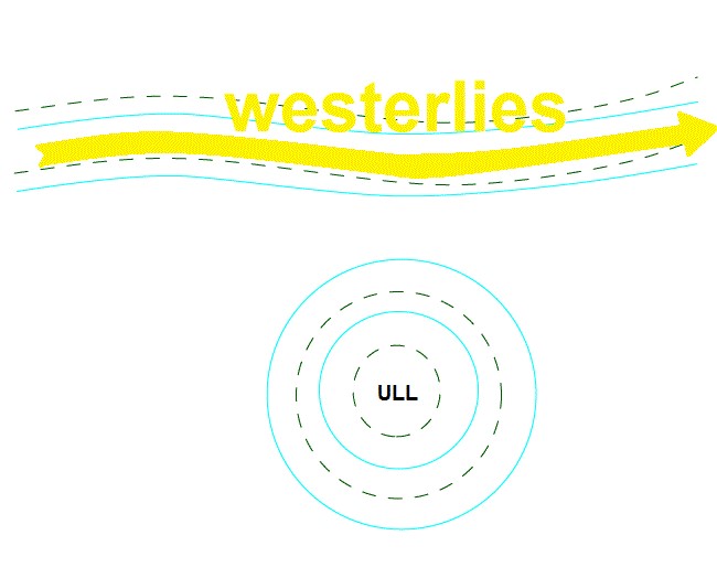
Figure 1: Schematic of the cut-off stage. Cyan lines represent the 500 hPa geopotential height and the dotted green lines the 500 hPa temperature.
Figure 2: IR loop from 15 July 2021 at 00 UTC to 16 July 2021 at 00 UTC. 500 hPa geopotential height in cyan and 500 hPa temperature in blue isolines.
The cut-off low consists in a cold drop of air at mid-tropospheric levels and strongly influences surface weather. The lowering of the tropopause brings colder air masses down to ground levels. This process is accompanied by rain showers and overcast skies.
The cold air at higher levels presents potential for unstable stratification, especially over warmer surfaces such as the ocean, which then increases the lapse rate above a critical value and triggers convection. Thunderstorms are also frequent over warm terrain.
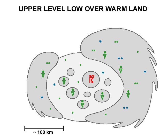
Figure 3: Weather symbols showing the typical surface weather conditions below an upper-level low.
Such weather conditions are frequently accompanied by high precipitation, especially when the ULL is stationary or only moving slowly as will be showcased in the last chapter of this module.
In contrast to classical cyclogenesis, upper-level divergence, which forms the ULL, does not lead to a corresponding low-level convergence. This might be because the dynamical process that formed the ULL was either short-lived and terminated at this stage and thus did not induce a corresponding surface low, or because frictional forces at lower levels hampered the creation of a surface low over land because upper-level forcing is too weak.
Unlike most upper-level troughs, the pressure gradient around an ULL is rather uniform and usually does not exhibit stronger gradients across different parts. Hence, if it is present, we can find the jet streaks all around the ULL (see Figure 4).
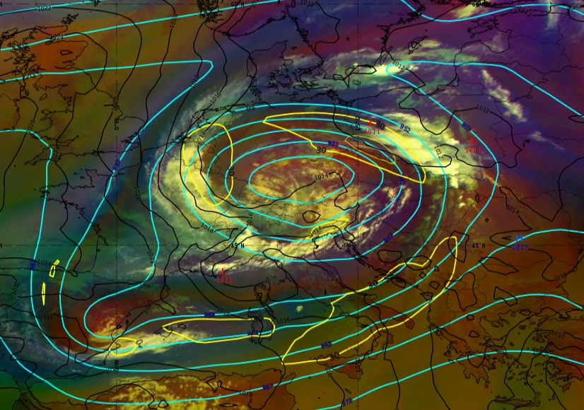
Figure 4: A cut-off low located over Central Europe (15 July 2021 at 09:00 UTC): Geopotential height at 300 hPa (cyan), isotachs at 300 hPa (yellow) and mean surface pressure (black)
The cloud pattern around the cut-off low often looks similar to an occlusion cloud spiral but without the same vertical structure as the formation process is completely different. Convective initiation is frequent underneath the cold air drop because of the increased vertical temperature gradient especially over warm ground.
According to the omega-equation, increasing positive (cyclonic) vorticity advection with height creates horizontal divergence near the tropopause and convergence near the ground. This produces upward motion and is another important trigger for convection.