MSG IR 10.8
1st March 2004: 11UTC
A set of images containing MSG High Resolution Visible gives a different perspective on the evolution the cloud spiral. At this timestep the initial spiral is seen west of Norway on 72N 2E.
1st March 2004: 01UTC
Between 00 and 06 UTC the dark area in the hv image representing dry air is widening and approaching E-ward. Thereby it is overrunning the lower cloud shield discussed in the sequence of IR images.
1st March 2004: 02UTC
Between 00 and 06 UTC the dark area in the hv image representing dry air is widening and approaching E-ward. Thereby it is overrunning the lower cloud shield discussed in the sequence of IR images.
1st March 2004: 03UTC
Between 00 and 06 UTC the dark area in the hv image representing dry air is widening and approaching E-ward. Thereby it is overrunning the lower cloud shield discussed in the sequence of IR images.
1st March 2004: 04UTC
Between 00 and 06 UTC the dark area in the hv image representing dry air is widening and approaching E-ward. Thereby it is overrunning the lower cloud shield discussed in the sequence of IR images.
1st March 2004: 05UTC
Between 00 and 06 UTC the dark area in the hv image representing dry air is widening and approaching E-ward. Thereby it is overrunning the lower cloud shield discussed in the sequence of IR images.
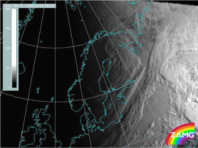
1st March 2004: 06UTC
Between 00 and 06 UTC the dark area in the hv image representing dry air is widening and approaching E-ward. Thereby it is overrunning the lower cloud shield discussed in the sequence of IR images.
Up to this point of time the first curl has developed at the western boundary of the cloud area in the center of the dry air above.
Such dry air quite often is a sign for a PV anomaly which is stratospheric air penetrating downward into the troposphere. As a consequence of this process the rotation becomes quite high and influences also deeper cloud layers which could be an explanation for the development of the curls.
1st March 2004: 07UTC
In the period from 07 to 13 UTC the development and intensification of the cloud spiral can be seen also in the hv image and the effect of the cyclonic rotation in the dry air (PV anomaly) is quite evident.
1st March 2004: 08UTC
In the period from 07 to 13 UTC the development and intensification of the cloud spiral can be seen also in the hv image and the effect of the cyclonic rotation in the dry air (PV anomaly) is quite evident.
1st March 2004: 09UTC
In the period from 07 to 13 UTC the development and intensification of the cloud spiral can be seen also in the hv image and the effect of the cyclonic rotation in the dry air (PV anomaly) is quite evident.
1st March 2004: 10UTC
In the period from 07 to 13 UTC the development and intensification of the cloud spiral can be seen also in the hv image and the effect of the cyclonic rotation in the dry air (PV anomaly) is quite evident.
1st March 2004: 11UTC
In the period from 07 to 13 UTC the development and intensification of the cloud spiral can be seen also in the hv image and the effect of the cyclonic rotation in the dry air (PV anomaly) is quite evident.
1st March 2004: 12UTC
In the period from 07 to 13 UTC the development and intensification of the cloud spiral can be seen also in the hv image and the effect of the cyclonic rotation in the dry air (PV anomaly) is quite evident.
1st March 2004: 13UTC
In the period from 07 to 13 UTC the development and intensification of the cloud spiral can be seen also in the hv image and the effect of the cyclonic rotation in the dry air (PV anomaly) is quite evident.
1st March 2004: 14UTC
From 13 to about 18 UTC the main process of the development of cloud curls and spirals at the boundary of the dry air in the hv goes on. But additionally, in the hv small scale dry centers are seen very well. In this type of image at least two dry spots indicate new developments of curls.
1st March 2004: 15UTC
From 13 to about 18 UTC the main process of the development of cloud curls and spirals at the boundary of the dry air in the hv goes on. But additionally, in the hv small scale dry centers are seen very well. In this type of image at least two dry spots indicate new developments of curls.
1st March 2004: 16UTC
From 13 to about 18 UTC the main process of the development of cloud curls and spirals at the boundary of the dry air in the hv goes on. But additionally, in the hv small scale dry centers are seen very well. In this type of image at least two dry spots indicate new developments of curls.
1st March 2004: 17UTC
From 13 to about 18 UTC the main process of the development of cloud curls and spirals at the boundary of the dry air in the hv goes on. But additionally, in the hv small scale dry centers are seen very well. In this type of image at least two dry spots indicate new developments of curls.
1st March 2004: 18UTC
The hv image very clearly shows a double structure in the comma cloud spiral with two black spots. At the same time in the
IR image the decay of the head of the spiral was mentioned. Consequently the formation of a new spiral will take place in the area of the second (more southern) dark spot.
1st March 2004: 20UTC
In the period from 20 to 23 UTC the structure in hv shows the two dark spots and the development of brighter grey shades (cloudiness) around the southern dark spot.
1st March 2004: 23UTC
At 23 UTC the new comma spiral and it hv environment is fully developed over N-Sweden. Over N-Norway the decay of the former spiral is still visible.
2nd March 2004: 03UTC
From 03 to 06 UTC the hv image shows some additional features compared to the IR image: the dry air is streaming over the lower cloud of the frontal band and there is a fibre visible in hv.
2nd March 2004: 06UTC
From 03 to 06 UTC the hv image shows some additional features compared to the IR imgage: the dry air is streaming over the lower cloud of the frontal band and there is a fibre visible in the hv
2nd March 2004: 09UTC
From 09 to 18 UTC the most interesting phenomenon in the hv image is that the dry air is streaming over the frontal cloud band and as a consequence a configuration typical for a split front arises. This has also been mentione in the sequence of IR images. Besides relevant numerical parameters, the hv image can explain the double structure partly by the overflow of dry air on the rearward side of the cloud band
2nd March 2004: 12UTC
The process of development of a synoptic scale cloud spiral is going on; in the hv image the most interesting phenomenon are the two black areas which are partly above the cloud band and partly behind. They represent dry air in upper levels with a high degree of cyclonic rotation
2nd March 2004: 15UTC
The process of development of a synoptic scale cloud spiral is going on; in the hv image the most interesting phenomenon are the two black areas which are partly above the cloud band and partly behind. They represent dry air in upper levels with a high degree of cyclonic rotation
3rd March 2004: 18UTC
The process of development of a synoptic scale cloud spiral is going on; in the hv image the most interesting phenomenon are the two black areas which are partly above the cloud band and partly behind. They represent dry air in upper levels with a high degree of cyclonic rotation