LST retrieval with unknown LSEs
The methods described so far assume the surface emissivity to be known. However, accurate estimations of LSE at the pixel scale are hard to achieve beforehand. LSE is a characteristic of the surface, varying with vegetation cover, surface roughness and soil moisture, which are difficult to account for in laboratory-based measurements. Several methods have been developed to derive LSE from the emitted radiance measured by a sensor. Such methods will not be presented here, but just as an example, Fig. 13 shows emissivity maps as computed by the LSA SAF (In the LSA SAF the surface emissivities for each sensor channel are estimated as an average of bareground and vegetation emissivities within each pixel, weighted with the pixel Fraction of Vegetation Cover (FVC). The bareground/vegetation emissivities have been assigned to each class of a land cover map [Peres and DaCamara, 2005; Trigo et al., 2008], FVC is routinely retrieved by the LSA SAF) for SEVIRI channels 3.9, 8.7, 10.8 and 12.0 μm.
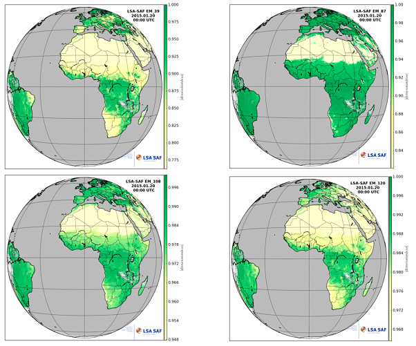
Fig. 13: Example of emissivity maps as computed by the LSA SAF SA SAF for SEVIRI channels 3.9, 8.7, 10.8 and 12.0 μm. The method uses the Vegetation Cover Method which considers the effective emissivity of each pixel as a weighted fraction of vegetation and bare ground components: εi = εivegFVC + εiground(1 - FVC). FVC is the Fraction of Vegetation Cover, a product also computed in the LSA SAF.
1. Stepwise retrieval methods
In stepwise retrieval methods the LST and LSE are computed in two steps. First, the LSE is (semi-) empirically estimated from visible/near-infrared measurements or physically estimated from pairs of atmospherically corrected MIR and TIR radiances at ground level. In the following step the LST is computed using any of the retrieval methods described above: single, multichannel (SW) or multi-angle (dual-angle).
2. Simultaneous LST and LSE retrieval methods with known atmospheric information
In these methods LST and LSE are simultaneously retrieved from the atmospherically corrected brightness temperatures (atmospheric information is known so the TOA brightness temperatures are reduced to the ground level) either by reducing the number of unknowns (can be done with Principal Component Analysis techniques) or increasing the number of equations. These methods are further classified as multi-temporal and multi (hyper)-spectral retrieval methods. Methods in the first group assume emissivity is invariant over time. Consequently, considering 2 time slots t1 and t2 the problem we need to solve will have 2N equations (N-number of channels) for N+2 unknowns (LSTt1, LSEch1, LSTt2, LSEch2):
| Channels (ch) | Time (t) | |
| 1 | 2 | |
| 1 | LSTt1, LSEch1 | LSTt2, LSEch1 |
| 2 | LSTt1, LSEch2 | LSTt2, LSEch2 |
From these methods two reference algorithms are the two-temperature (Watson, 1992) which considers a scene at two times in the diurnal cycle (optimally after midday and midnight), and the physics-based day/night (Wan & Li, 1997). In order to reduce the error of the atmospheric corrections, the latter method introduces two variables (air temperature at the surface level (Ta) and atmospheric water vapor (WV)) to modify the initial atmospheric profiles. With two measurements (day and night) in N channels, the number of unknowns is N+7 (N channel LSEs, 2 LSTs, 2 Ta, 2 WV, and 1 angular form factor in the MIR channels). Thus, to make the equations deterministic, the number of channels used in the retrieval must be equal to or greater than seven. Due to the high number of required spectral channels this method of solving LST cannot be used with the sensors onboard GOES; MSG, Metop. On the other hand, the MODIS (Moderate Resolution Imaging Spectroradiometer) with its seven TIR bands is suited to use this method for measuring surface temperatures.
https://cimss.ssec.wisc.edu/rss/bertinoro/source/text/15.pdf
Multi (hyper)-spectral retrieval methods use hyperspectral TIR data as input (that provides much more detailed information on the atmosphere and land surface) and rely on the intrinsic spectral behavior of the LSE.
3. Simultaneous LST and LSE retrieval methods with unknown atmospheric information
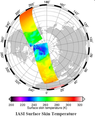
Fig. 14: LST estimated from the EUMETSAT Infrared Atmospheric Sounding Instrument (IASI) onboard the Metop satellite.
The simultaneous LST and LSE retrieval methods take advantage of the narrow bandwidth of the thousands of channels available from hyperspectral TIR sensors that improve the vertical resolution and allow atmospheric profiles and surface parameters (LST and LSEs) to be obtained more accurately (Chahine et al., 2001). An example of LST estimated from the Infrared Atmospheric Sounding Instrument onboard Metop is shown in Figure 14.