Cloud Motion Winds (CMW)
The tracking of cloud or moisture features from satellite data does not automatically provide in-situ winds since clouds can be stationary (e.g. lee clouds) or move in a direction not coinciding with the local wind field (e.g. cumulonimbus clouds). Therefore it is very important to distinguish between motion vectors and winds. Motion vectors provide the direction and propagation speed of a selected cloud feature, while winds represent the current velocity of an air parcel at a certain height.
In practice this differentiation is achieved by a careful selection of atmospheric tracers and the use of model winds as a first guess for wind speed and direction at a given atmospheric level. For example the displacement of a front line results in atmospheric motion vectors while using a cloud fiber as tracer suits the computation of cloud motion winds better. Both applications have strengths as will be shown in some practical applications in chapter 3.
The computation of cloud motion winds requires model data anyway, not only for the first guess comparison and validity check, but also for the height assignment of the derived winds. This is achieved by assigning the brightness temperature of the tracer cloud to a given height by using a vertical temperature profile from a model.
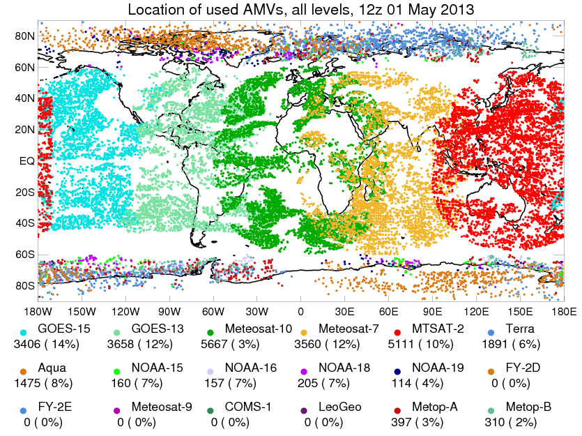
Table 1 gives an overview of the agencies currently producing and disseminating cloud motion winds and the satellites used for that purpose. Altogether the data provides a nearly global coverage, see Figure 3.
Table 1: List of agencies currently producing cloud motion winds (green: geostationary satellites, red: polar orbiting satellites).
| EUMETSAT | Europe | Meteosat-10 (GEO), Meteosat-7 (GEO), MetOp-A (P), MetOp-B (P) |
|---|---|---|
| NOAA/NESDIS, CIMSS | USA | GOES-13 (GEO), GOES-15 (GEO), Aqua (P), Terra (P), NOAA-15 (P), NOAA-18 (P), NOAA-19 (P), NPP (P) |
| JMA | Japan | MTSAT-2 (GEO) HIMAWARI 6 - 8 |
| IMD | India | Kalpana (GEO), INSAT-3D (GEO) |
| CMA | China | FY-2D (GEO), FY-2E (GEO) |
| KMA | South Korea | COMS (GEO) |
Figure 3: Location of all AMVs used in the data assimilation for the UK Met Office model in 2013 (Source: UK Met Office).
Methodology
The methodology is explained with help of AMVs derived from the SEVIRI instrument onboard MSG. Various satellite channels are used to calculate cloud motion. The IR window channels (IR10.8 μm, IR12.0 μm) and the visible channels (VIS0.6 μm, VIS0.8 μm) are used for cloud tracking. In contrast, both WV channels (WV6.2 μm, WV7.3 μm) provide information for cloudy and cloudless areas. For the latter, moisture patterns or gradients are tracked instead of clouds.
The algorithm to derive cloud motion winds mainly consists of the following steps:
- Initialization of the data
- Tracer selection
- Tracking
- Height assignment
- Quality control
- Orographic flag computation
Ad 1: Initialization of the data: In this preprocessing step the algorithm provides all the auxiliary data needed in the following stages for computing the winds (e.g. pixel latitude and longitude, solar zenith angle, reflectance and brightness temperatures for all used channels ...). This preprocessing step is crucial as the exact location of the feature is critical for all the further calculations.
Tracer selection: In this first step a cloud or moisture feature that can be tracked easily, has to be identified. Some clouds make better tracers of the atmosphere's motion than others. The EUMETSAT target extraction scheme mainly depends on the contrast and the entropy as selection criteria. Therefore suitable targets have the highest contrast and the largest amount of standard deviation (entropy).
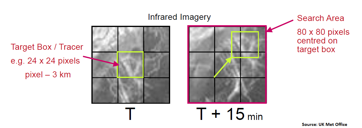
Ad 3: Tracking: The motion of the cloud/moisture feature is extracted by analyzing two or more consecutive images (see Figure 4 ). This task usually uses a large amount of computational resources. Thus, various methods can be used:
- Euclidean distance
- Cross correlation in the spatial domain
- Cross correlation in the Fourier domain
At EUMETSAT a cross correlation is used.
Figure 4: Tracking a cloud pattern for deducing an AMV.
Ad 4: Height assignment: In this step a pressure level is assigned to the vector based on a temperature/pressure profile derived either from radiative transfer calculations in the environment of the target or from model data. When computing AMVs from WV images in a region with clear sky conditions, the brightness temperature from the latter is used for the height assignment.
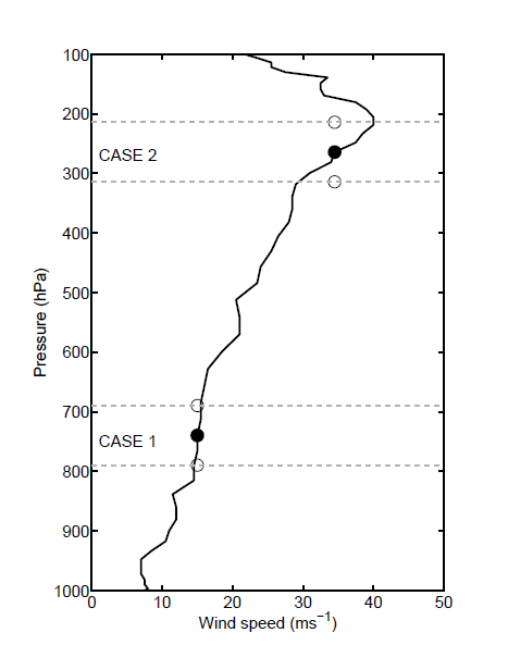
Height assignment is the most important, but also the most difficult step as it is very error-prone. An error of +/- 50 hPa can induce a major wind speed error especially at levels with high wind shear (see Figure 5).
Figure 5: The impact of a height error on the wind speed at two different levels (Source: Salonen et al.).
There are several difficulties with the height assignment:
- Which pixel of the target area should be selected for height assignment?
- Which level is the most representative of cloud motion? Normally the cloud top temperature is assigned to a pressure level. Furthermore, each layer of the atmosphere emits a different amount of radiation, which is true especially for absorption channels. However in the end the AMV is treated as single-level data in NWP models.
- The assigned pressure level is normally calculated as a function of the cloud type. Semi-transparent or sub-pixel clouds are often the best tracers as they provide good radiance gradients, but their height assignment is very tricky as the measured radiance contains a large and unknown contribution from lower cloud layers and/or the earth surface.
At EUMETSAT height assignment is usually done by the two following algorithms:
- Equivalent Black Body Temperature (EBBT): the measured brightness temperature of the tracer is compared to forecast temperature profiles in order to infer the level of best agreement. This level is chosen as the observation height. The EBBT method shows good results for opaque clouds. In semi-transparent or sub-pixel clouds this technique often assigns insufficient height to the clouds. A big advantage of this method is that it is available almost everywhere.
- Cross Correlation Contribution Method (CCC): defines AMV pressure by only considering the pressure in the pixels that contribute to image correlation best.
Ad 5: Quality control: Quality control is part of the post-processing procedure. This step is crucial in determining whether a derived motion vector fulfills the criteria of satellite-derived wind. During this process each motion vector is automatically set to a quality flag. This quality flag is the result of several independent quality tests:
- Forecast consistency: speed and direction of measured and forecasted wind at the same altitude are compared to each other
- Spatial consistency: neighboring wind vectors (same time-step, same level) are compared
- Temporal consistency: the wind vectors of consecutive time steps are compared to each other
- Temporal pressure consistency: altitude and pressure set to the 2nd and 3rd time step are compared to each other
- Image correlation (WV6.2 μm, IR10.8 μm): at EUMETSAT this is done between WV and IR images
The weighted sum of all individual quality tests represents the final Quality Index QI which ranges from 0 to 1. Distinct QI thresholds determine whether a motion vector can be used as wind equivalent or not.
Ad 6: Orographic flag calculation: This is another post-processing step in which tracers affected by land are detected and finally rejected. For example, tracers whose flow is blocked (e.g. barrage cloudiness) or affected by mountain ranges (e.g. lee waves) are not representative of atmospheric motion.
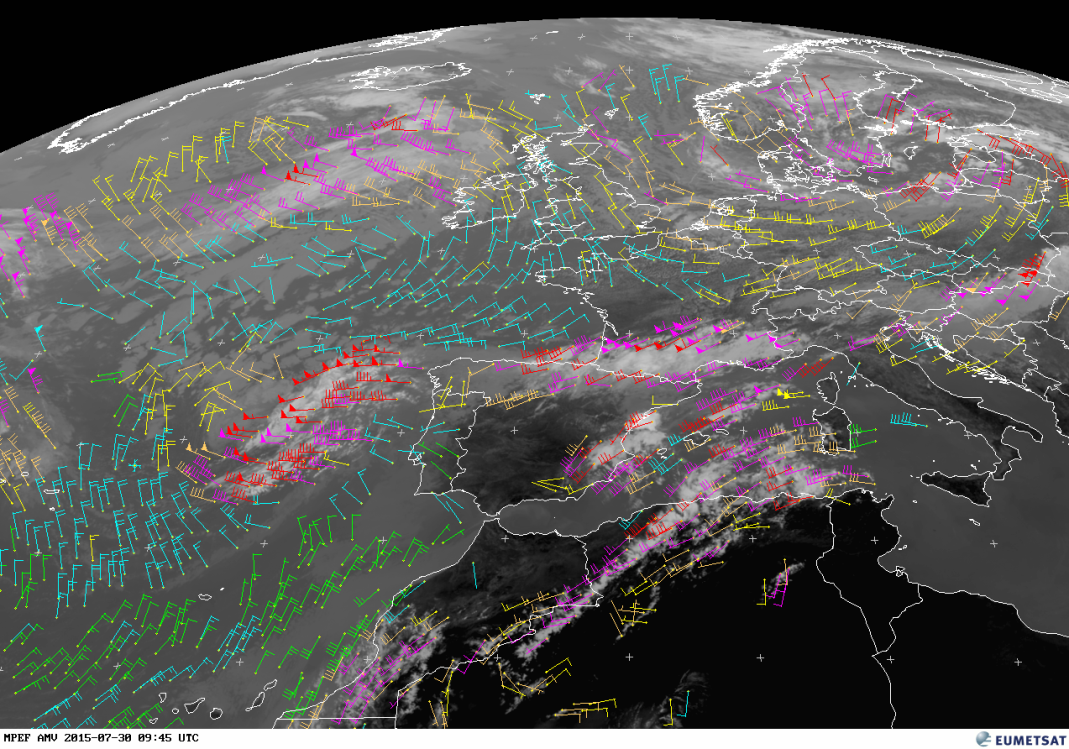
Figure 6 Shows the result of the entire algorithm described above: a satellite derived wind product from EUMETSAT. The different colors of the wind vectors represent different height levels.
Figure 6: Example of satellite-derived wind product from EUMETSAT.
Polar Satellites
Initially AMVs were computed using only data from geostationary satellites. Thus, AMV data was available from 55° latitude north to 55° latitude south. Theoretically AMVs can also be derived in regions near the poles, but given the strongly inclined satellite viewing angle the quality of the wind vectors thus obtained would be quite bad. Hence there was a constant lack of observations in polar regions. In the early 2000s, NOAA started to routinely produce polar wind vectors by using MODIS data. Nowadays AVHRR and VIIRS data are also used for computing cloud motion winds and so they are available at latitudes greater than 70°. NWP models in particular benefit from this development as polar regions had long been data scarce areas. Polar wind vectors are mainly used in data assimilation.
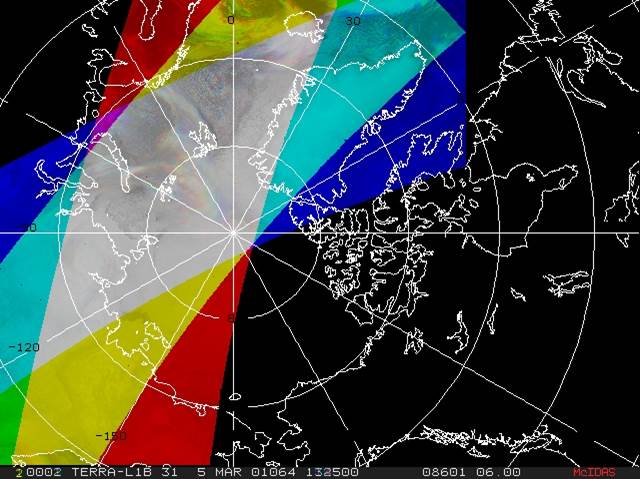
Extracting satellite winds over polar regions brought not only improvements for the forecaster community but also new challenges. A large time interval of about 50 to 100 minutes between consecutive images, small areas for tracking, viewing angle problems, parallax shifts and varying pixel size are only some of the problems. For tracking a feature and thus determining the motion vector, normally two (EUMETSAT) to three (CIMSS/NOAA) consecutive images are used. As the orbit of polar satellites is shifted for each overpass due to the Earth's rotation, only a small area where three consecutive overpasses overlap is available (see Figure 7). Due to the long temporal gap between consecutive images, only the most persistent clouds can be tracked. Matching the features is also more demanding as the cloud shape might change in such a long period. Nowadays, image pairs instead of image triplets are used for deriving motion vectors. On the one hand, the global coverage of cloud motion winds is increased by the addition of polar satellites, but on the other hand the quality of the wind information thus determined might decrease a bit.
Height assignment for polar winds
In polar regions the tropopause is lower than in middle or tropical latitudes. Therefore the first step in height assignment is checking that the tracer cloud is not situated above the tropopause. The level of the tropopause is determined by using forecast fields. The altitude of the tracer cloud is then restricted to a layer between the ground and the forecasted tropopause level. AVHRR measurements represent a special case as no appropriate water vapor or CO2 channels are available. Because of this only the EBBT method can be used for height assignment. If available, EUMETSAT uses the IASI cloud top height product for determining the cloud top pressure. However, due to the coarse sampling of the IASI instrument this data does not cover the whole area scanned by the AVHRR instrument.
Figure 7: AMVs can be derived from polar-orbiting satellite imagery where the successive overpasses overlap (shown in grey) in polar regions (Source: D. Santek (CIMSS)).
Combination of GEO/LEO or MetOp-A/B data
Geostationary and polar data help to achieve a good global coverage of cloud motion winds. Nevertheless a data gap exists between roughly 55° and 70° latitude and therefore synoptic phenomena like polar jet streams are partly not reflected in AMV data. This problem can be solved by combining either geostationary and polar satellite data or data from two LEO satellites situated in the same orbital train, such as MetOp-A and MetOp-B.
An advanced method is used to blend imagery from LEO and GEO satellites in order to produce composite CMWs. Data from geostationary satellites (GOES) is blended with data from polar satellites (NOAA-15 through NOAA-19, MetOp-A, NASA's Terra and Aqua). When computing these CMWs, high-spatial-resolution LEO data is the first choice if available. If not, high time resolution GEO data is used. The satellite winds are produced using three half-hourly composites. These mixed-platform wind vectors seem to be comparable to other available CMWs in terms of the root-mean-square error. Recent experiments have shown that these composite wind vectors tend to have a positive impact on the forecasts in the southern hemisphere. In the northern hemisphere the impact seems to be neutral.
On 17 September 2012, EUMETSAT launched the MetOp-B satellite. This tandem configuration of two satellites - MetOp-A and MetOp-B - operating on the same orbital train with a phase difference of 46 to 55 minutes provides the opportunity of creating not only polar but global AMVs from LEO data. When compared to CMVs from geostationary satellite data only minor differences regarding the assigned height of the derived winds are noticeable. As MetOp satellites do not operate water vapor channels the methods for height assignment are restricted as mentioned earlier.
