Examples of interpretation
Two cases are shown with and without annotations to demonstrate the proper interpretation of different surface and cloud types in the Night Microphysics RGB images (Figs. 7 and 8).
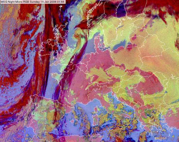
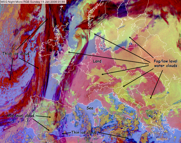
In Fig. 7 frontal cloudiness is seen over the Atlantic Ocean and the western coast of Europe. In Central Europe we see a 'cold pool situation'. This is a typical late autumn or winter weather situation over the Carpathian Basin with long lasting fog or stratus clouds. The fog/low stratus forms in high pressure conditions. Cold air accumulates in the basin. Warmer air may advect above it, further increasing the vertical stability. There is no notable wind in the lower layers. These circumstances are favourable for the forming of long-lasting fog or stratus cloud. The temperature is low and the air is humid in the basin. The summits and ridges of the mountains are often above the layer of fog or stratus, and the weather is sunny and warm compared to the conditions in the basin.
| Figure 7: Night Microphysics RGB for 15 January 2006 at 01:55 UTC with and without annotations. |
|
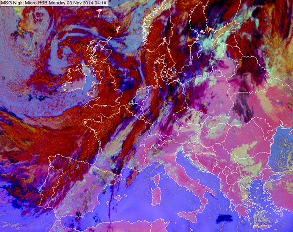
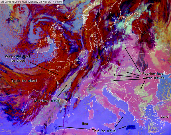
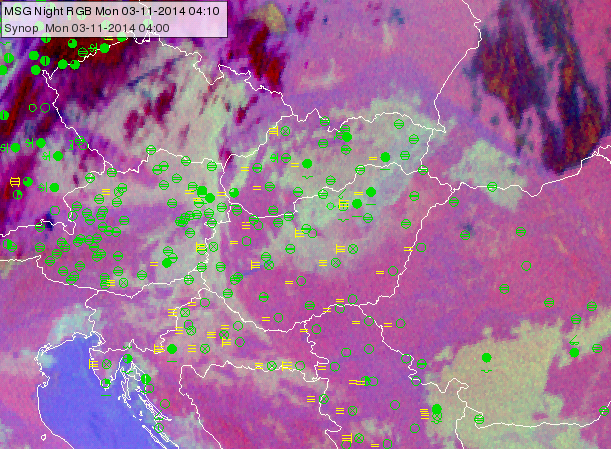
In Fig. 8 we see a situation where a high pressure weather situation prevailed in southeast Europe. Previously, there had been a 10-day period without any frontal activity in the Carpathian Basin, which resulted in the so called 'cold pool' situation. There is frontal cloudiness over western and northern Europe, and an elongated frontal zone over the Finnish-Russian border and Belarus.
Fogs are forming due to nighttime radiation cooling (see the SYNOP observation in Fig 8b). The fog's formation and dissipation can be followed in the animation (3 November 2014, 00:10-13:10 UTC) created before sunrise from Night Micrphysics, and after sunrise from HRV Fog RGB images.The fog dissipates in several areas during daytime due to warming and air motion. In central Hungary relatively thin fog forms, and dissipates. South of the Carpathian Mountains and in the Czech Republic the fog is thicker. Thick low-level water clouds have a strong greenish colour; and the thinner the (radiation) fog, the more the colour resembles the pinkish colour of the ground. Very thin fog (e.g. only fog in the lowest 10 or 20 m) can be so similar to the ground that they can no longer be detected in the Night Microphysics RGB. This can be seen in Figure 8 and the corresponding loop, such as over Hungary. For example, there is thicker fog/stratus over northern Hungary and thinner fog over central Hungary in the 03:10 UTC image. As expected, the thinner fog dissolves more quickly, as one can see in the HRV Fog RGB loop of the following morning hours. So, the forecaster can use the colour of the fog to forecast possible dissolution. There are other areas (in Slovenia and Croatia) with thinner fog that dissolves more quickly.
Note that in the presence of a thermal inversion the mountains appear bluer than the lowland in the Night Microphysics RGB images. Stronger shades of blue signify higher temperatures.
| Figure 8: Night Microphysics RGB for 03 November 2014 at 04:10 UTC with and without annotation. |
|
| Figure 8b: Night Microphysics RGB for 03 November 2014 at 04:10 UTC overlaid by SYNOP observations |
|
| Animation 1: Time sequence of fog formation and dissipation (03 November 2014 00:10-13:10 UTC): Night microphysics RGB images (00:10-05:55 UTC) and HRV Fog RGB images (06:10-13:10 UTC) |