The aim of this RGB type is to distinguish fog and low clouds from cloud-free areas at night. This is very important for traffic security. Fog or stratus usually forms at night by radiation cooling, and since in-situ observations are rare, satellite information is vital.
At night two RGB types are useful for this purpose: the Night Microphysics and the 24 hour Microphysics RGBs. The colour contrast between surface and low clouds or fog is better in the Night Microphysics RGB images, but unfortunately during daytime and twilight this RGB type is not usable.
Although the main goal is the detection of fog and low clouds, the Night Microphysics RGB reveals also other types of clouds.
Physical basis
Which channels are useful for nighttime fog or low cloud detection?
At night only infrared (IR) channel data is usable. Since we are interested in low clouds, only the "atmospheric window" IR channels are useful. (In an "atmospheric window" channel the absorption of the gas molecules is low.) For cloud-free surfaces and opaque clouds the measured signal in the atmospheric window channels depends mainly on the temperature of the measured object (sea, land, cloud top). The signal also depends on emissivity, as well as slightly on atmospheric effects. For semitransparent clouds the interpretation of the measured radiation is more complicated.
The 'traditional' 10.8 micrometer channel (IR10.8) is included in the Night Microphysics RGB because it separates the thick clouds according to their cloud top temperatures. However, for our purposes one channel is not enough. Using only one single IR channel, the detections of two cloud types are problematic:
- It is difficult (or impossible) to separate fog or low water clouds from the surrounding cloud free surface as their temperatures are close to each other. Fog and low clouds can be mistakenly detected as cloud-free areas.
- It is difficult (or impossible) to separate semitransparent clouds from opaque clouds. On a single IR channel a semitransparent cloud looks like a thick, warmer cloud.
The problems above could be solved by analyzing the following brightness temperature differences:
- The (IR12.0-IR10.8) difference helps to distinguish thick and thin clouds.
- The (IR10.8-IR3.9) difference helps to solve both problems mentioned above.
These differences are used in the Night Microphysics RGB together with the IR10.8 channel.
Separation between cloud free surface and fog or water clouds
The technique is based on two facts:
- The emissivity values of the water clouds and the surface are about the same in the IR10.8 and IR12.0 channels. As a consequence, water clouds are hard to detect in IR10.8 and IR12.0 images.
- The emissivity values of the water clouds and the surface differ slightly in the IR3.9 channel. As a consequence the fog or stratus is not well seen in the IR3.9 images either, but still a little better than in the IR10.8 or IR12.0 channels.
The difference between water cloud and the surface will be more pronounced in the (IR10.8-IR3.9) difference image. The difference will be high for water clouds (or fog) and small for cloud-free surface.
Detection of semitransparent cirrus clouds
Cirrus clouds consist of ice crystals and are often semitransparent. In case of thin clouds some part of the radiation coming from below goes through and so the radiation reaching the satellite is a 'mixed radiation': the brightness temperature is higher than the real temperature of the cirrus clouds. The more transparent the cirrus cloud, the higher the resulting brightness temperature. The brightness temperature of a semitransparent cloud depends mainly on its real temperature, its transparency and the temperature of the underlying surface.
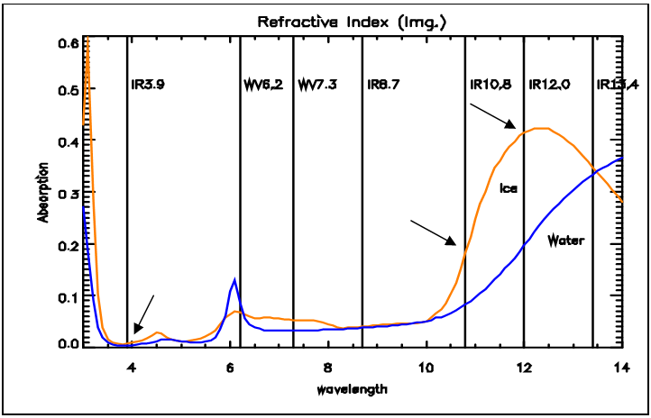
For semitransparent clouds the BT difference of two channels depends strongly on the transmissivity difference. The transparency of thin ice clouds is considerably different around 3.9, 10.8 and 12.0 micrometers, as the ice's absorption is rather different at these wavelengths (see Fig. 1). Thin cirrus clouds can be detected by the (IR12.0-IR10.8) and (IR10.8-IR3.9) differences (large negative differences).
| Figure 1: Absorption spectra of water (blue curve) and ice (orange curve) (Source: MSG Interpretation Guide, EUMETSAT) |
|