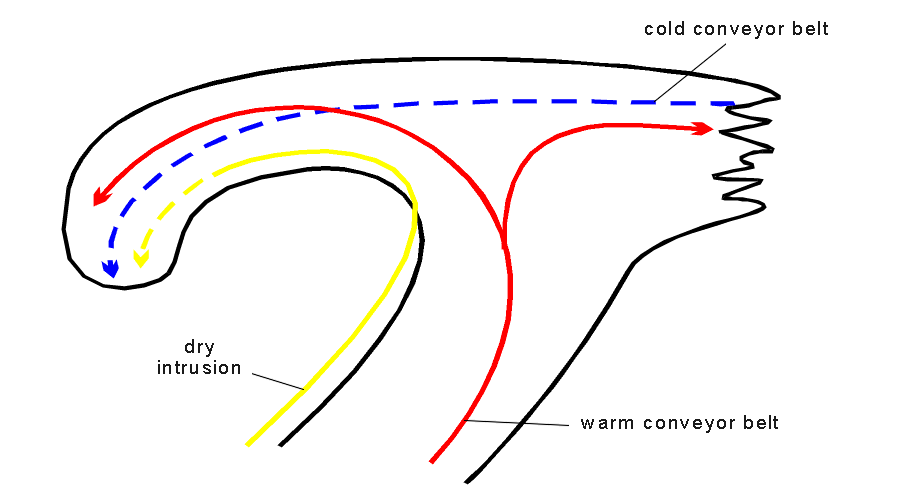
The conveyor belt theory for the Cold Front deals predominantly with two relative streams: the warm conveyor belt and the dry intrusion. The warm front deals predominantly with the relative streams of the warm conveyor belt and the cold conveyor belt. For the Occlusion all three conveyor belts are relevant:
- The warm conveyor belt is a rising relative stream from south, south-eastern directions turning to north, north-eastern directions; it transports warm and moist air.
- The dry intrusion is a sinking relative stream from north-west to south-east, splitting into two branches: a
further sinking one to the south-west and a rising one to the north-east.
The cold conveyor belt is a rising relative stream from east, south-east which is initially below the warm conveyor belt, but then emerges from below and extends to northern directions.
The structure and formation of the cloud spiral of the warm conveyor belt Occlusion type can also be described with the conveyor belt theory as follows:
- An ascending cold conveyor belt can be found parallel to the surface warm front. At the point of the Occlusion it penetrates from below the warm conveyor belt and turns cyclonically forming the cloud spiral. The relative stream of the cold conveyor belt is a main relative stream forming the Occlusion cloud band. In this Occlusion type it is hidden below higher level cloudiness which is related to the middle and upper level streams. Within the cyclonic turn the ascending motion changes into a descending motion which causes the decrease of the frontal cloud tops.
- The higher levels of the troposphere are characterized by the relative streams of the warm conveyor belt and the dry intrusion. The configuration of the warm conveyor belt depends on the stage of development. In the early wave stage the warm conveyor belt ascends within the cloud band of the Cold and Warm Front where it turns anticyclonically parallel to the surface warm front. During the warm conveyor belt type of the Occlusion development, described in this chapter, the warm conveyor belt develops to a ridge-like hook over the occlusion band and later on splits into two parts: the eastern branch follows the cloud band of the Warm Front while on the western branch it follows the cloud spiralof the Occlusion.
Graphical representation of the warm and conveyer belt and the dry intrusion
- The dry intrusion is accompanied by descending air originating from the upper levels of the troposphere and/or the lower
levels of the stratosphere. The dry intrusion is approximately to the rear cloud edge of the cloud spiral of the Occlusion.
If at all it overruns only the boundary zones of the cloud band. These are the areas predestined for the development of Cb
Cloudiness, which often can be observed in the images as well as in the synoptic weather reports. The following reasons for the convective development can be found:
- the air advected within the dry intrusion has lower values of relative humidity than the air of the cold conveyor belt; this leads to the development of a conditionally unstable stratification;
- a PVA maximum indicating moving curvature vorticity contributes to upward motion according to the omega equation.
References