1 - Introduction
The distribution of vegetation, its properties and state, is of major importance for a wide range of applications, namely:
- Environmental management;
- Natural Hazards monitoring;
- Agriculture and forestry;
- Climate change studies;
- Numerical weather forecast models.
Changes in the landcover either caused by changes in land use, climate change or natural hazards (like forest fires or droughts, for instance) may have a huge social and economic impact. An example of this was the severe drought that stroke Eastern Africa in 2009, causing crops to shrink and threatening millions of people with starvation (the-great-drought-in-east-africa).
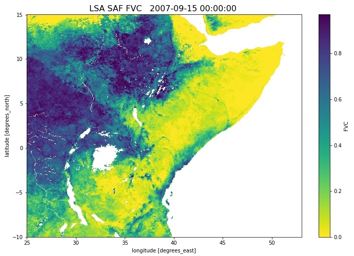
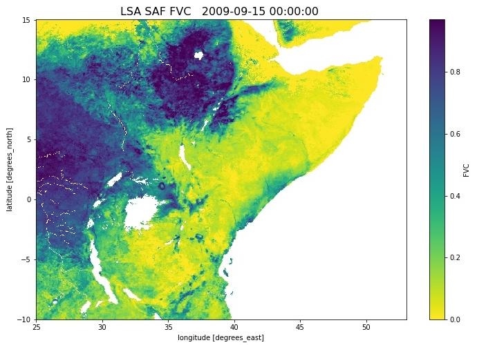
Remote sensing provides the best means to monitor changes in vegetation over a wide range of temporal scales over large areas. As an example, the decrease in vegetation cover associated to the 2009 Eastern Africa drought, is shown in the comparison between an image of the Fraction of Vegetation Cover in 2007 to the same period during the 2009 (please use the slider to see the change):
|
|
Figure 1: Fraction of Vegetation Cover product obtained on the aim of LSA SAF project, from SEVIRI sensor on board Meteosat Second Generation (MSG) satellite.
Click
here to open a gallery of the two images.
Several empirical indices have been proposed and used through the years, which allow an easy identification and monitoring of the vegetation conditions from satellite measurements. However such indices have several disadvantages. Because they are ratio based, they are nonlinear, have noise effects and are not structural properties of land surface areas. There are several key variables that can be use for a wide range of land biosphere applications that are more directly related to vegetation properties and health than conventional empirical indices. The Satellite Application Facility on Land Surface Analysis (LSA SAF) produces several of those variables, making then available both in near real time and off-line.
The module aims at giving an overall view on the use of satellite data, particularly that provided by Meteorological satellites, for monitoring vegetation cover and properties. It is organized as follows: chapter 2 focus on basic physical concepts; chapter 3 details how vegetation interacts with radiation and describes satellite sensors suitable to retrieve information from vegetation surfaces; chapter 4 shows how the unique spectral signatures of vegetation described in the previous chapter can be used to derive widely used empirical indices and their relation with vegetation properties; chapter 5 presents several vegetation products, which are key variables for the monitoring of dynamic changes in the structure and the functioning of vegetation at the earth surface; and finally chapter 6 provides a list of references where you can find more information about several module subjects.
This module was thought for a broad community, which includes users from: weather forecasting and climate modelling, requiring detailed information on the nature and properties of land; environmental management and land use, needing information on land cover type and land cover changes; users dealing with agricultural and forestry applications, requiring information on incoming/outgoing radiation and vegetation properties; natural hazards managers, requiring frequent observations of terrestrial surfaces.
This module was created within the EUMeTrain project by Carla Barroso (LSASAF, Portuguese Met. Service) and Isabel Monteiro (LSASAF, Portuguese Met. Service).

