TPW products from geostationary orbiting (GEO) satellites
TPW retrieval from GEO satellites is done by imager and sounding instruments. In 2014, TPW products were available from the SEVIRI sensor (imager) onboard Meteosat 8, 9 and 10, and from the sounders on board U.S. GOES 13, 14 and 15. They will also be available from the ABI (Advanced Baseline Imager) sensor on board GOES-R (projected launch in April 2016). The SEVIRI and the future ABI sensors scan the atmosphere in the visible and infra-red spectral ranges. The retrieval algorithm is very similar for both sensors and uses data from spectral channels in the IR range from 6 to 13 µm. U.S. GEO satellites have been able to derive total precipitable water (and other instability parameters) from their sounder instruments since the development of the experimental products on GOES-8 in the mid 1990's. The GOES Sounder TPW product became operational with round the clock support (24 x 7 x 365) in the early 2000's. See http://cimss.ssec.wisc.edu/goes/sounder/products.html for a short write-up and http://www.ssd.noaa.gov/PS/PCPN/pcpn-na.html for the current operational products.
In addition to the accumulated water vapour (TPW) product from the various geostationary satellites, a "Layer Precipitable Water" product (LPW) that is subdivided into three layers is also produced. The vertical extent of these layers varies depending on the properties of the sensors. For the above-mentioned instruments, they are defined as follows:
| Layer | SEVIRI | GOES Sounder | ABI |
|---|---|---|---|
| Boundary Layer | 1000 - 850 | 1000 - 900 | Surface - 900 |
| Middle Layer | 850 - 500 | 900 - 700 | 900 - 700 |
| High Layer | 500 - top | 700 - 300 | 700 - 300 |
Table 1: Vertical extent of the LPW product from SEVIRI, GOES Sounder and the future ABI instrument in [hPa].
The exact vertical extent of the three layers also depends on the overall synoptic situation as the pressure can drop below 900 hPa in the center of some low pressure systems. In other cases, such as over high altitude areas, pressure at the surface may be lower than 700 hPa.
Some TPW Products from different GEO satellites are:
- The Global Instability Index (GII) from EUMETSAT (Figure 1) which includes a TPW product
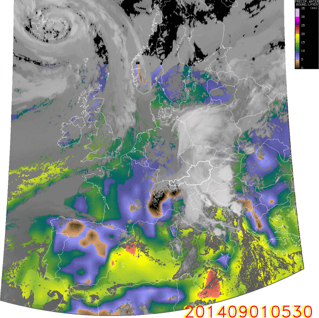
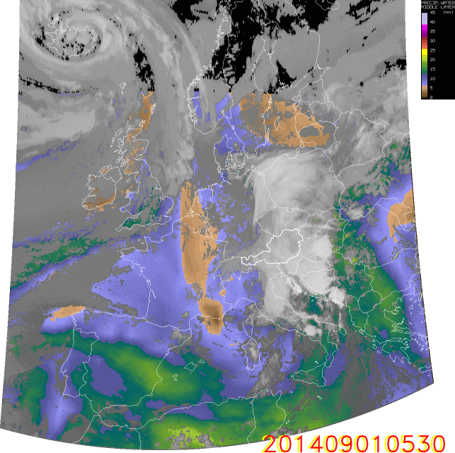
- The SEVIRI Physical Retrieval product (Figure 2) from the NoWCasting-SAF (www.nwcsaf.org)
- Current GOES (13, 14 and 15) Sounder TPW Product (Figure 3) (www.ssd.noaa.gov/PS/PCPN/pcpn-na.html)
- The future TPW product from the GOES-R ABI sensor
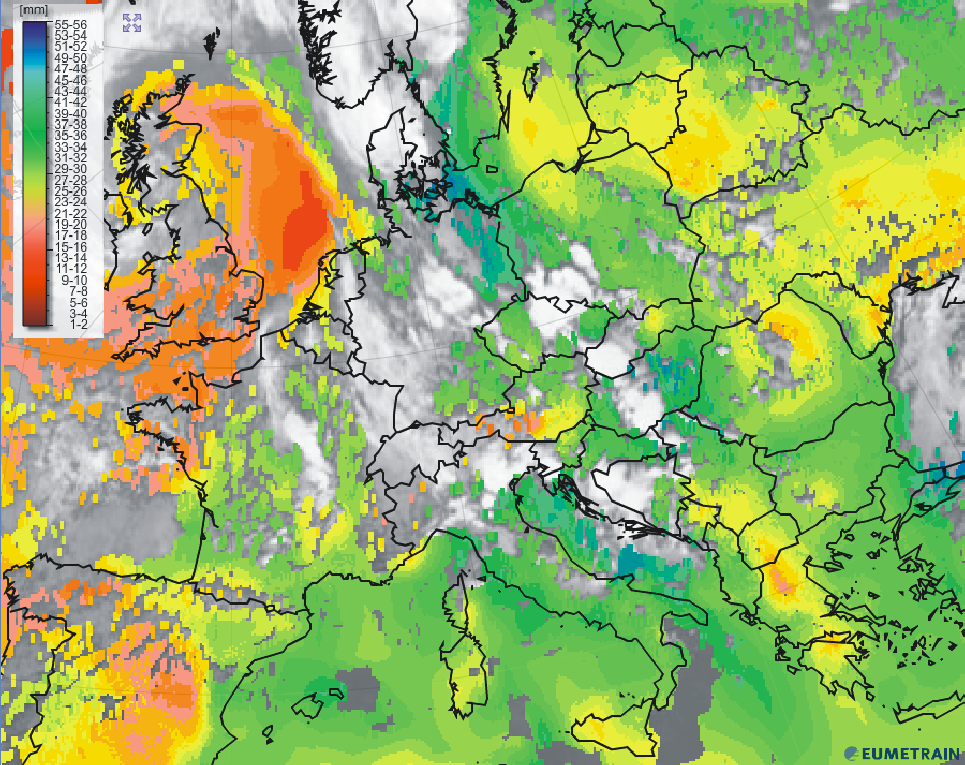
Figure 1: TPW product from EUMETSAT on 3 August 2014, 12:00 UTC. The amount of precipitable water is given in millimetres.
|
|

|

|
Figure 2: LPW boundary layer (top left); middle layer (top right); high layer (bottom left) and TPW (bottom right) on 1 September 2014, 05:30 - 13:00 UTC. Click on the animation to enlarge it.
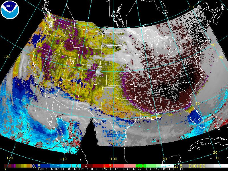
Figure 3: Operational GOES sounder-derived product "precipitable water" on 8 January 2015 at 08:00 UTC.
The calculation of TPW products involves assumptions on the vertical profile of temperature and humidity. Both parameters can also be used to derive indices reflecting atmospheric stability. For this reason TPW products are often derived in a software package including stability parameters such as the Lifted-, K- or Showalter index. In fact, the combination of TPW fields with stability information is often beneficial and will be shown in the next chapter.
For the TPW product based on SEVIRI, GOES Sounder or future ABI data, TPW can only be retrieved from clear sky pixels. Information from cloudy pixels must be provided beforehand by a cloud mask. Background numerical weather profiles are a mandatory input to the TPW algorithm. The limited number of spectral channels compared to sounding instruments onboard polar orbiting satellites has implications on the vertical resolution of retrieved temperature and humidity profiles. As far as the SEVIRI sensor is concerned, water vapour concentration can be retrieved from the upper and middle troposphere down to approximately 700 hPa. Lower levels and especially the boundary layer are invisible for both SEVIRI WV channels (6.2 and 7.3 µm). Background NWP parameters are needed to correct this detriment. As a result, the derived TPW values are strongly biased towards NWP values.
On the plus side, TPW products from geostationary sensors (except GOES Sounder) are available every 5 minutes in rapid scanning mode. In situations with strong discrepancies between NWP profiles and measured atmospheric conditions, satellite-derived TPW values are corrected accordingly.
Note