TPW retrieval from GEO satellites
Geostationary satellites like Meteosat Second Generation (MSG) can provide information on the quantity of atmospheric water vapour although their sounding capabilities are limited.
Besides offering three window channels in the IR range, MSG-SEVIRI also provides two channels in the water vapour absorption band (6.2 µm and 7.3 µm). While the IR window channels are measuring the radiation emitted from the earth's surface (or cloud tops), both absorption channels reflect the amount of water vapour along the optical path from the radiation emitting surface to the satellite sensor.

Figure 6: Absorption of radiation depending on its wavelength for selected atmospheric trace gases. The red line marks the 6.2 µm and the magenta line the 7.2 µm band.
Both channels lay in the water vapour absorption band which reaches from about 5 to 8 µm. While the channel centred around 6.2 µm is located in the middle of the absorption band, the position of the 7.3 µm channel is on the edge of the absorption band (Figure 6). The consequence is that surface radiation emitted at 6.2 µm is much more strongly absorbed by atmospheric water vapour than radiation at 7.3 µm.
In reality, all surface radiation is completely absorbed by atmospheric water vapour on its way to the satellite. Each absorbing VW molecule emits radiation according to Planck's law, mainly depending on its temperature. As a consequence, the satellite only "sees" the atmosphere - or, to be more exact, the radiation emitted by WV molecules.
Now, as the extent of the absorption differs depending on the wavelength, the satellite "sees" different levels of the atmosphere. This effect is comparable to the visibility range in fog of varying density. The different atmospheric layers contributing with emitted radiation from VW molecules to the satellite measured total (or integral) radiation is represented in so called "contribution functions" (Figure 7).
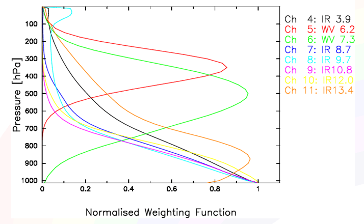
Figure 7: Contribution functions for MSG-SEVIRI IR channels (Source: EUMETSAT)
Figure 7 shows that radiation measured by the SEVIRI sensor at 6.2 and 7.3 µm (red and green line) originates from the mid- and higher levels of the troposphere. Hence we get information on water vapour content from 2 different atmospheric levels.
As the number of absorption channels is limited for currently operating GEO satellites and water vapour mainly concentrates in lower tropospheric levels, additional information (e.g. from numerical models) is needed to retrieve the TPW content.
Note
GEO satellite sensors (e.g. MSG-SEVIRI) provide WV information from mid- to higher tropospheric levels only.