Kelvin-Helmholtz instability
The origin of transverse cloud bands lies in the vertical velocity shear caused by the subtropical jet stream. When wind shear increases (as is the case near the jet streak), frictional forces within the stable stratified air increase. Friction between layers with differing wind speed leads to small disturbances forming a wave-like pattern within the atmospheric stream, similar to the way wind interacts with an ocean's surface. When the air is near saturation, ice crystals form at the wave crest. This can be detected in satellite images. When the wind shear is strong enough, the Kelvin-Helmholtz waves will break (see figure 3) and lead to moderate or severe turbulence.
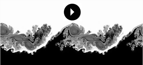
Figure 3: Numerical simulation of Kelvin-Helmholtz instability (source Wikipedia)
Notice:
| Transverse cloud bands visible in WV imagery are an indication of turbulence in the upper troposphere. However, the absence of transverse bands is not a sign of a laminar atmospheric flow, since Kelvin-Helmholtz waves become visible only when the air is nearly saturated with moisture. |