Synoptic Analysis
The convection commences with a large upper-level low situated over Western Europe, and a very unstable airmass that moves from the Mediterranean to Central and Eastern Europe (Fig 2.1).
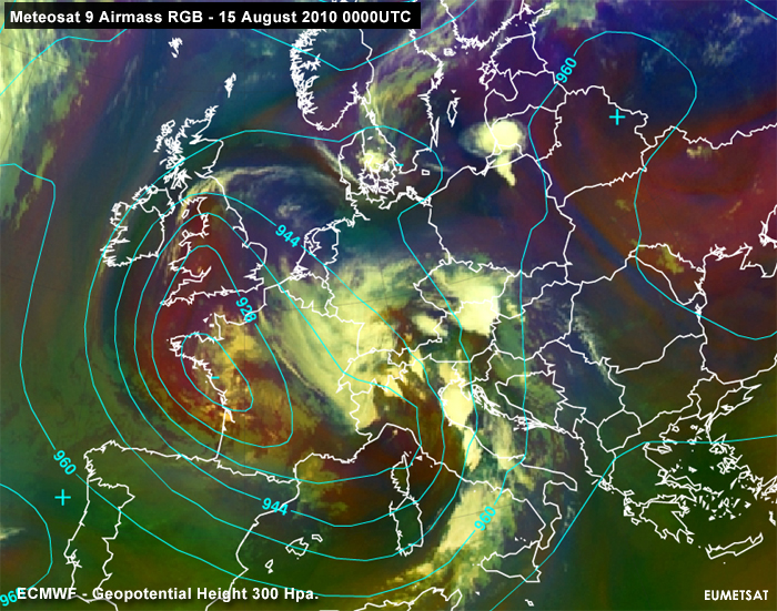
Figure 2.1: Meteosat 9 Airmass RGB with ECMWF Geopotential Height 300 hPa. - 15 August 2010 0000UTC
In addition to that, during the night of August 15th, a surface low is developing north of the Alps over Bavaria, which becomes evident in the equivalent thickness between 850 and 500 hPa. as illustrated in Figure 2.2.
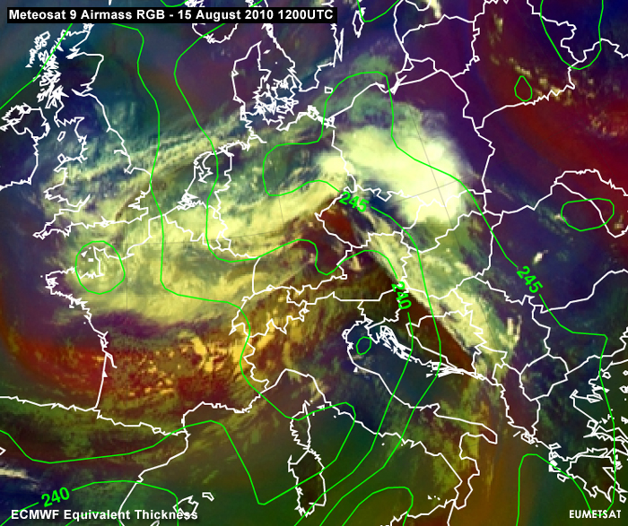
Figure 2.2: Meteosat 9 Airmass RGB with ECMWF Equivalent Thickness. - 15 August 2010 1200UTC
During the day a jet axis, which occurs on the southern flank of the upper level vortex, is moving in a north-eastern direction to the Alps. In the second half of the day, the left exit region is situated over the eastern parts of Austria and the Czech Republic. In the Meteosat 9 - Airmass RGB image (Fig 2.3), stratospheric dry air is detected on the northern flank of the jet axis (reddish colour from southern France via Switzerland and parts of Austria to the Czech Republic). That is to say that a general instability or lifting is initiated, too. Widespread convection can be expected.
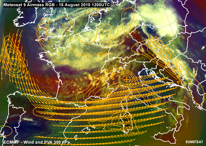
Figure 2.3: Meteosat 9 Airmass RGB with ECMWF Wind and PVA at 300 hPa. - 15 August 2010 1200UTC
However, the most unstable airmass is found over Hungary, Slovakia and Poland. Nocturnal thunderstorms and new developments in the early morning over Slovakia indicate a very unstable airmass. You can also see this in the soundings of these regions (Poprad-Ganovce 00UTC - Fig 2.4), where MLCAPE values of 1000-1500 J Kg-1 are found. Somewhere in this region, CAPE will probably reach high values.
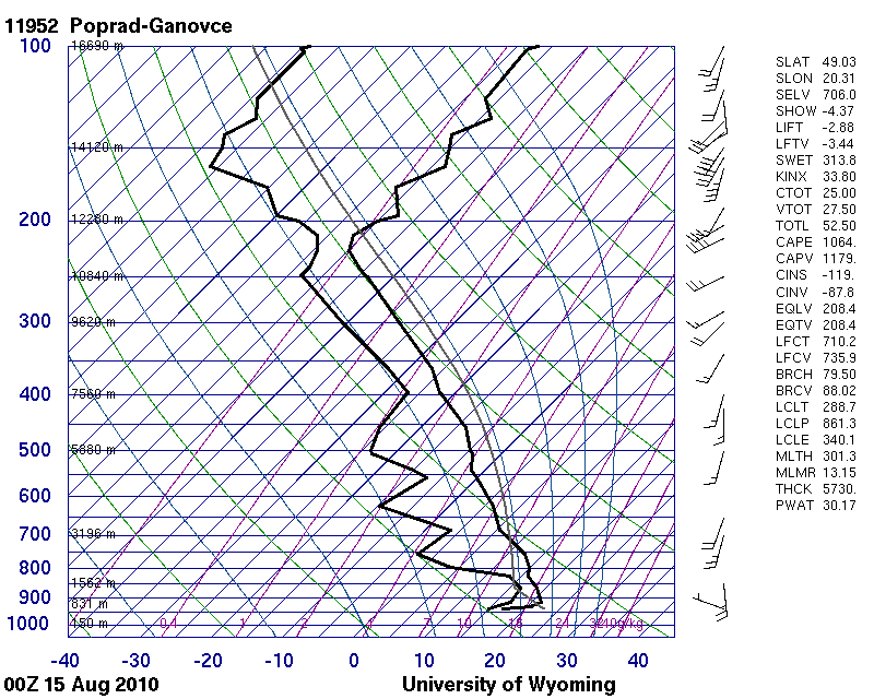
Figure 2.4: Radio Sounding Poprad-Ganovce - 15 August 2010 0000UTC (source: the University of Wyoming)
Budapest is mainly situated in the unstable and very humid airmass. Values between 2000 and 2500 J Kg-1 MLCAPE are computed. One can also detect a significant dry mixed-layer (between 850 and 650 hPa.) with a steep lapse rate. Humid air is lying below and as a consequence a notice is given for large hail and severe downbursts. Also, take note of the high precipitable water (PWAT) which indicates the necessary moisture in the lower layers.
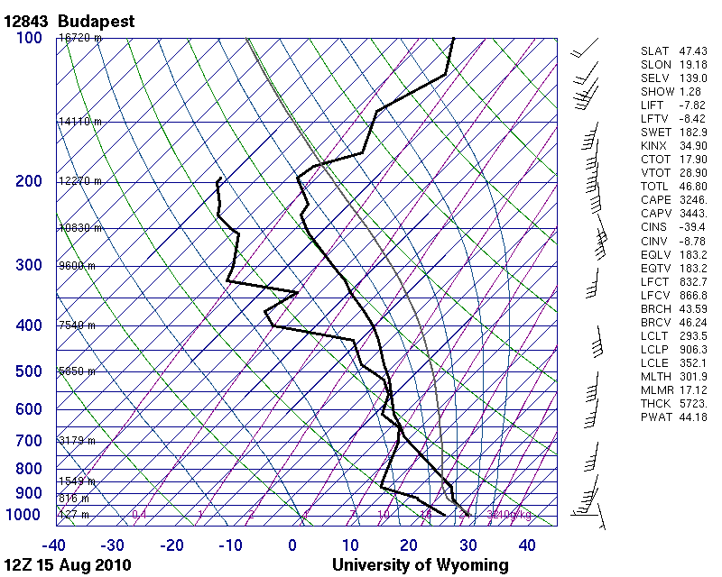
Figure 2.5: Radio Sounding Budapest - 15 August 2010 1200UTC (source: University of Wyoming)
At 12UTC the instability has increased due to increasing insolation and large MLCAPE-values in combination with low values of convective inhibition (CIN).
CIN (Convective Inhibition)
In the atmosphere there are often layers which are warmer than a rising parcel. Therefore a negative buoyancy energy must be overcome to reach layers that are colder than the rising parcel. Such layers are like thick caps that inhibit deep convection. If the layer (for example inversions) and therefore the negative energy is very small, parcels can easily conquer such a layer and reach high altitudes.
The mixed layer still exists and is quite humid above the DLS-layer. Heavy thunderstorms with large hail and downbursts are likely to occur. In addition to that, the DLS values are reaching 20 m/s, enough to produce organized structures. The combination of warm, humid airmass (over Hungary, Slovakia and Poland) strong DLS and high values of MLCAPE is likely to lead to the development of widespread, organized thunderstorms.
DLS (Deep Layer Shear) is the vertical wind shear between the 0 to 6 km level aloft. The unit is m s-1 or kn. If the DLS is very strong (with values greater than 20 to 25m s-1) heavy thunderstorms are more probable.
During 15 August, the situation in Prague was a clear day with good insolation nearly to the end.
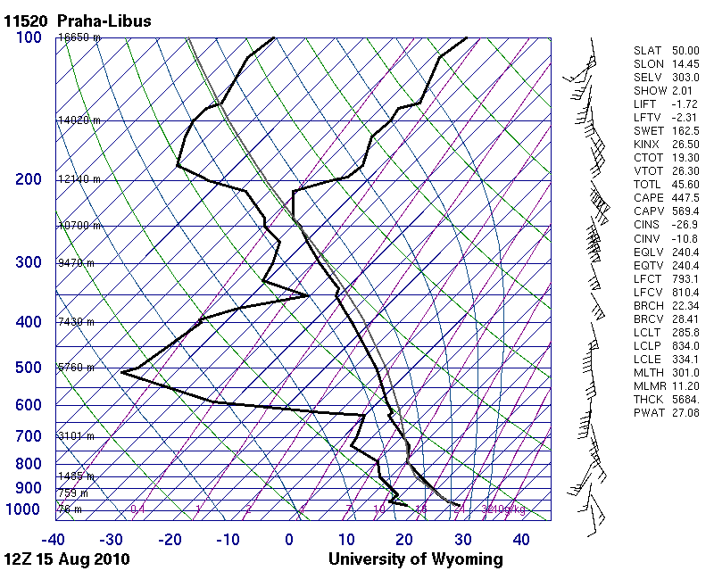
Figure 2.4: Radio Sounding Prague - 15 August 2010 1200UTC (source: University of Wyoming)
In the afternoon drier air reached Prague in the lowest layers. This was observed by an increasing visibility range. But the air above is still unstable and in the afternoon some isolated thunderstorms were initiated around Prague. It is clear that while at lower levels there is still an airmass with a high potential temperature. Above it, there is a dry and cool airmass with high lapse rates (above 600 hPa), adding to the generation of "convective" instability. Also pay attention to the wind speed (45 kn) at 500 hPa at 12UTC. The wind speed, along with the wind shear, further increases at 500 hPa in the afternoon and evening, which favors well-organized thunderstorms.
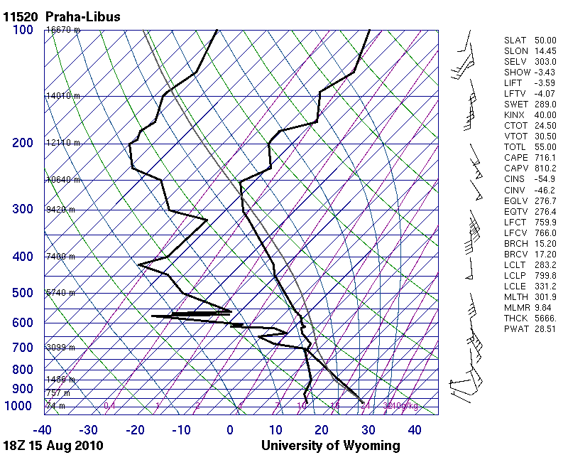
Figure 2.5: Radio Sounding Prague - 15 August 2010 1800UTC (source: University of Wyoming)
The dry air in the lowest layers could also support downbursts due to evaporation cooling. In the evening a maximum of Positive Vorticity Advection (Fig 2.6) is found over Prague, and it prepares widespread lifting and upper level divergence.
Also, on that day a convergence zone in the Czech Republic was capable of initiating severe thunderstorms. Another important point for this case study is the tropopause deformation in the dry intrusion. This is likely the primary factor that confirms that the "warm appearance" of the Prague hailstorm in the standard IR-BT temperature panel is the storm. Just compare, for example, the Prague 18 UTC and Budapest 12 UTC soundings for the height and temperature of the tropopause. A clear difference is seen and that is to say that the tropopause over Prague was quite a bit lower than over Budapest.
After the passage of the first heavy thunderstorm, a cold front with a second line of thunderstorms follows some hours later.
Figure 2.6: Meteosat 9 IR10.8 with ECMWF Wind and PVA at 300 hPa. - 15 August 2010 1800UTC