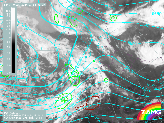
1st July 2004: 06UTC
There is a large upper level trough behind the CF cloud band in the area of cold air cloudiness over England and the North-Sea. Two PVA maxima, one over Denmark and the other over Germany and East France, indicate a NE-ward displacement of the upper level trough.
1st July 2004: 12UTC
This is still the development phase of the frontal system. The upper level trough behind is very pronounced, the two PVA maxima already detected before indicate its movement and give an idea about the intensification of the cloudiness there. Especially the more southern PVA maximum has intensified.
1st July 2004: 18UTC
At this point of time the first sign of a Wave development at '1' is observed. The situation at 500 hPa is more or less unchanged. There is an upper level trough and a PVA max in advance. The latter is south of the probable Wave area and thus supports a wave development.
2nd July 2004: 00UTC
A double structure in the cloud feature of the wave can be noticed and is marked as '1' and '2' in the image. The corresponding PVA max is related to the southern part of Wave '2'. This parameter supports the idea of a further development of Wave '2' in comparison to Wave '1'.
2nd July 2004: 06UTC
The southern part of Wave '2' shows pronounced development, which is supported by a deepening of the upper level trough and a PVA max within and south of Wave '2'.
2nd July 2004: 12UTC
Immediately behind wave '2' a distinct cloud spiral has developed, which is accompanied by an upper level trough and a PVA maximum in advance, no further intensification can be seen in these fields. The new southern Wave '3' is situated in an upper level zonal stream. No distict PVA maximum can be detected (yet).
2nd July 2004: 18UTC
For wave '2' the upper level trough is very intensive but no (new) PVA maximum can be recognised. In connection with wave '3' a smooth, new upper level trough can be recognized over Western Austria. Consequently also the PVA max observed over Eastern-Austria has increased.
3rd July 2004: 00UTC
The small scale upper level trough has propagated to Eastern Austria, but not intensified. Another PVA max has appeared just south of the Alps. It is in good accordance with wave '3'.
3rd July 2004: 06UTC
At this point in time for Wave '3a' a well developed upper level trough can be observed at the rear over Romania. No distinct PVA max however, accompanies it at the time being.
3rd July 2004: 12UTC
A dramatic increase in PVA max during the past 6 hours is observed. It can be the sign for the start of a rapid cyclogenesis development from this period of time on.
3rd July 2004: 18UTC
The main feature is the more and more distinct upper level trough at the rear and partly above the frontal cloud band south of cloud bulge '3'.
4th July 2004: 00UTC
At this timestep the lowering of cloudtops immediately south of the Wave bulge takes place. This is in accordance with the fact that the upper level trough is no longer at the rear side of the frontal cloud band, but has moved over it.
4th July 2004: 06UTC
As cloudiness in the area of the upper level trough has nearly dissolved, the trough now seems to be again behind the frontal cloud band but looking at the image in the visible channel there is still a continuous cloud band there.
4th July 2004: 12UTC
As cloudiness in the area of the upper level trough has nearly dissolved, the trough now seems to be again behind the frontal cloud band.
4th July 2004: 18UTC
As cloudiness in the area of the upper level trough has nearly dissolved, the trough now seems to be again behind the frontal cloud band.