Isotachs and Positive Vorticity Advection at 300 hPa.
1st July 2004: 06UTC
When a Jet Streak crosses a frontal zone under a large acute angle an increase of cloudiness as a consequence of PVA maxima in the right entrance or in the left exit region of this crossing jet streak can be observed. In this case, and in the relevant fronts, there are very dominant jet streaks over the Atlantic reaching Britain and along the northern edge of the CF band mainly over Germany. The latter jet streak consists of two small scale maxima. There is one PVA maxima over France, which is partly in the right entrance region, and a second PVA maximum can be found over Poland, situated in the left exit region. Both PVA maxima are in areas of intensifying clouds. But for both maxima it seems to be clear that also curvature connected to an upper level trough contributes to the values of PVA.
1st July 2004: 12UTC
The PVA maximum over France has moved eastward into Germany, but has remained its position in relation to the jet streak. It is interesting to observe that, as before, the jet streaks consist of small scale maxima. These situations are of interest as they are very often connected to rapidly developing PVA maxima and cloud systems
1st July 2004: 18UTC
At this time the cloud bulge over Poland already starts to reveal some indications of a Wave structure. Comparing the isotachs and the PVA maxima at 300 hPa, there is a relation between the cloud bulge area and the left exit region of a huge jet streak. Enhancement by a PVA maximum is evident.
2nd July 2004: 00UTC
As before the PVA max in the left exit region of the huge West-East orientated jet streak is very intensive and also comprises the new Wave area around '2'. However, the main part of the PVA maximum is more to the south of Wave '2' and will intensify cloudiness in this area of the cloud band. In a previous chapter the IR satellite images were discussed and the question arose why this splitting of the Wave area ('1' and '2') takes place. From this parameter one can say that the PVA maximum and its northern submaxima are in relation to the new development '2'.
2nd July 2004: 06UTC
Two distinct PVA maxima in connection with jet streaks are recognized in this image. One maximum over Poland and the Baltic States, connected to the Wave '2' just discussed, which is now developing. A second, new one, coincides with the increasing cloud behind the CF over Germany. This PVA maximum is in the center of the jet streak maximum. A relationship either to the left exit or to the right entrance region is not yet possible.
2nd July 2004: 12UTC
At this point of time the Wave '2' is developing together with a comma immediately behind; its rotation is very distinct. Indeed it is accompanied by a PVA maximum which can be found mainly in the left exit region of a jet streak. However, also rotation connected to an upper level trough plays an important role.
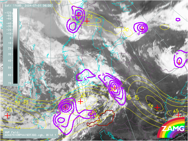
There is not yet any change in the PVA max over the Czech Republic but a new maximum west of Austria is coming into play
2nd July 2004: 18UTC
Several substructures have been dicussed in the cloud images.
1.) The wave '2' and '2a'. It still shows a connection to a PVA max at 300 hPa, but -as already stated before- not to the left exit refion of a jet streak. 2.) Typical area of front intensification by a crossing jet streak around position '*'. This is very clearly supported by a PVA maximum over White Russia in the left exit region. 3.) The rather extended area of a possible new Wave development around '3' and '3a'. Both cloud areas are accompanied by a PVA maxima at 300 hPa. However, they are not yet related to an exit or entrance region of a jet streak. Of much interest is the new jet streak reaching from the Atlantic into France.
3rd July 2004: 00UTC
There is not much change in the relation of cloud structures and the upper air features looked at in this chapter. But, the increase of the PVA maximum over Hungary is very close to the wave '3a'. It is in the transition area between the easterly jet streak from Croatia to Ukrain and the western one from France into Austria. Such a constellation is called a V-pattern and PVA is corresponding to both the right entrance region of a downstream and the left exit region of an upstream jet streak. This can be observed very well for this case.
3rd July 2004: 06UTC
The main and important feature of the distinct wave bulge '3a' is accompanied by a PVA max. All qualities are the same as described for the previous 6 hours. Especially, the V-pattern and the increased PVA max from both developing areas of the two jet streaks are pronounced. One difference notable is the development of a smaller scale jet streak extending from Austria to Hungary. The secondary maximum within the big PVA max is clearly a consequence of the left exit region of the new jet streak. This PVA max is also in close agreement with the cloud bulge.
3rd July 2004: 12UTC
The connection between the developing cloud bulge and the PVA maximum in both, the right entrance and (more and more important) the left exit region of the small scale streak over Eastern Europe is obvious. A triggering of the Wave development from above is evident. This explanation is supported by the fact that at this point of time no reflection can be found in the surface height field. However, the TA at 700 hPa, which represents middle levels of the troposphere, shows for the first time a WA maximum. This would support an influence from high levels downward into middle levels.
3rd July 2004: 18UTC
The same observations as six hours before can be stated for this timestep as well. The surface fields do not show any low pressure system, but the PVA max in the left exit region of a huge jet streak at high levels is very impressive and WA is intensifying at 700 hPa as well.
4th July 2004: 00UTC
The PVA max at 300 hPa still exists. The relation, however, to the jet streak is no longer a driving factor. The wave development (the cyclogenesis) has been released from above and seems to have protruded downward. At this point of time the first indication of a surface low pressure area can be recognized.
4th July 2004: 06UTC
The process described before is continued.
4th July 2004: 12UTC
The cyclogenesis is further developing.
4th July 2004: 18UTC
The Wave has transformed into an Occlusion and at this stage it is good to make a small comparison between the two Waves.
1) The northern Wave '2a' the features of the surface and upper air could not really be described by left exit region, since the PVA maximum was more to the north.
2) The southern Wave '3a' no surface features in the early stages, but a dramatic release from upper air cyclogenesis with PVA maxima in the left exit and right entrance regions, responsible for the long first time part development from upper to middle to low levels of the troposphere.