Extra Tropical Transition


General information: 5 August 2004 0001 UTC
Alex turned away from land and accelerated as it became embedded the west-southwesterly flow. At this time Alex began moving moving east-northeastward at 20-25 KT before accelerating to around 40 KT.
Alex turned away from land and accelerated as it became embedded the west-southwesterly flow. At this time Alex began moving moving east-northeastward at 20-25 KT before accelerating to around 40 KT.
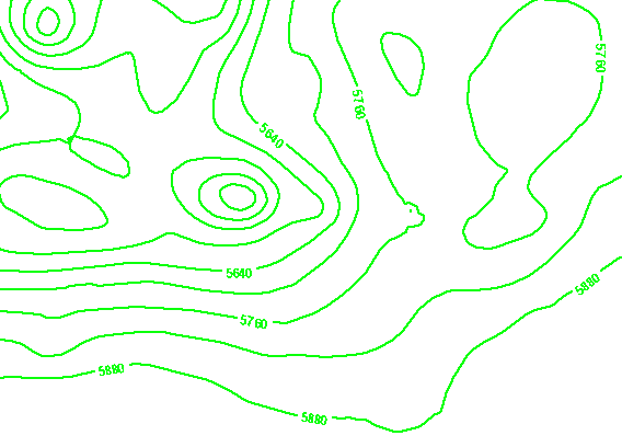
300 hPa contours
Alex has now become fully engaged in the strong zonal flow over the Atlantic and began to rapid move eastwards. If the steering flow is more zonal, perhaps also in association with a high NAO index, the resultant extra-tropical cyclone will head eastwards towards Europe. If the flow is meridional, as with a low NAO index, it is more likely to be steered in a more northerly direction parallel to western Europe.
Alex has now become fully engaged in the strong zonal flow over the Atlantic and began to rapid move eastwards. If the steering flow is more zonal, perhaps also in association with a high NAO index, the resultant extra-tropical cyclone will head eastwards towards Europe. If the flow is meridional, as with a low NAO index, it is more likely to be steered in a more northerly direction parallel to western Europe.
300 hPa winds
Alex has now moved over cooler waters and has begun to become influenced by the strong westerly flow. The cirrus shield has now moved over the hurricane eye and it is no longer evident.
Alex has now moved over cooler waters and has begun to become influenced by the strong westerly flow. The cirrus shield has now moved over the hurricane eye and it is no longer evident.
300 hPa isotachs
Alex has now moved over cooler waters and has begun to become influenced by the strong westerly flow. The cirrus shield has now moved over the hurricane eye and it is no longer evident.
Alex has now moved over cooler waters and has begun to become influenced by the strong westerly flow. The cirrus shield has now moved over the hurricane eye and it is no longer evident.
500 hPa contours
A short wave upper trough at 500 hPa is positioned well to the west of the hurricane.
A short wave upper trough at 500 hPa is positioned well to the west of the hurricane.
Thickness
Thickness values are now increasing over a large are of the western Atlantic with warm advection occurring several hundreds of kilometers ahead of the tropical storm.
Thickness values are now increasing over a large are of the western Atlantic with warm advection occurring several hundreds of kilometers ahead of the tropical storm.
850θw
High values of θ W of 20-22 ° C extend from the Hurricanes source region and are now extending further over the Atlantic. A weak frontal band is evident over the Labrador straits, further frontal systems are evident over Europe.
High values of θ W of 20-22 ° C extend from the Hurricanes source region and are now extending further over the Atlantic. A weak frontal band is evident over the Labrador straits, further frontal systems are evident over Europe.
Water Vapour 6.2µm
High humidity warm tropical air is seen extending well into the Atlantic to the east and southeast of Alex, shown as a light grey colour. The jet is seen extending into the Atlantic to the north of Alex, the PV feilds match well with this area. The hurricane eye has dissipated and become disorganised.
High humidity warm tropical air is seen extending well into the Atlantic to the east and southeast of Alex, shown as a light grey colour. The jet is seen extending into the Atlantic to the north of Alex, the PV feilds match well with this area. The hurricane eye has dissipated and become disorganised.
Water Vapour 7.3µm
The elongated dark feature to the north of Alex is now extending further over the Atlantic. The trough which had been positioned to the southwest of the UK has now relaxed further, and a zonal flow has become established over the western Atlantic. Alex lies away from the development areas associated with the jet and the eyewall has decayed.
The elongated dark feature to the north of Alex is now extending further over the Atlantic. The trough which had been positioned to the southwest of the UK has now relaxed further, and a zonal flow has become established over the western Atlantic. Alex lies away from the development areas associated with the jet and the eyewall has decayed.
PV at 300 hPa
The PA area has further extended as the jet increases in velocity and distance to the north of Alex. PV maximum to the west of the UK has now retracted to the north as the confulent trough continues to relax. PV anomily associated with the outflow of Alex is still evident, this is likely to be due to the descending air within the hurricanes centre dragging stratospheric air into the development.
The PA area has further extended as the jet increases in velocity and distance to the north of Alex. PV maximum to the west of the UK has now retracted to the north as the confulent trough continues to relax. PV anomily associated with the outflow of Alex is still evident, this is likely to be due to the descending air within the hurricanes centre dragging stratospheric air into the development.
(This was also observed in the cross sections)