From the satellite perspective, the development of a Shapiro-Keyser cyclone looks very similar to the classical Norwegian cyclone type. At first glance and from the evolution of the cloud pattern during the life cycle, no major differences can be observed. However, many Shapiro-Keyser cyclones show a rapid deepening of the surface low during their development phase and can therefore be characterized as a Rapid Cyclogenesis. Another difference is that Norwegian cyclones often form in low-index situations while Shapiro-Keyser cyclones primarily form in high-index situations. However, the characteristics of a Shapiro-Keyser cyclone can be best observed when we make use of NWP fields to analyse the involved physical processes.
Introduction
The Shapiro-Keyser cyclone model was developed in the late 1980s, benefitting from data made available by meteorological satellites and numerical model simulations. This conceptual model was named after the authors of the study that first presented it (M. A. Shapiro and D. Keyser, 1990). The authors discovered that, for some types of cyclogenesis, the meteorological data seemed not to confirm to the classical Norwegian cyclone model, in which the occlusion process results from a merging of the cold and the warm front. Instead, they observed a cold frontal fracture at the place where the cold front should smoothly turn into the warm front. Another major characteristic of Shapiro-Keyser cyclones is that they exhibit a warm core in contrast to the Norwegian type which shows a cold core.
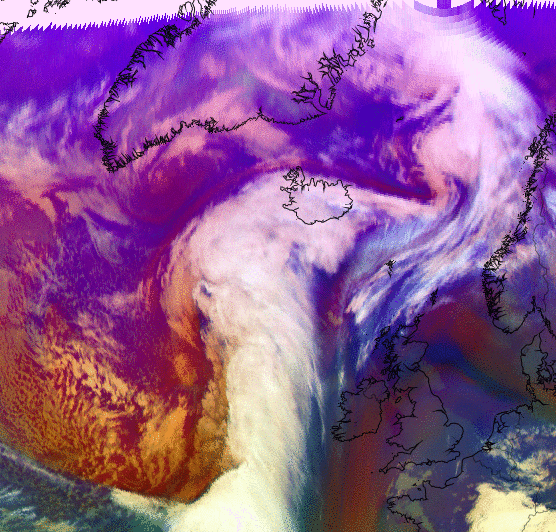
Figure 1: Rapid cyclogenesis developing over the northern Atlantic (8 - 9 January 2018). The pressure in the centre of the low drops from 961 hPa to 946 hPa in less than 24 hours.
In the above Airmass RGB loop, we can observe the formation of a cloud spiral (commonly named occlusion) which is not the result of a classical occlusion process as described by the Norwegian cyclone theory. The formation of this "occlusion" cloud band is best described with help of the conveyor belt theory.
1. Initial Condition
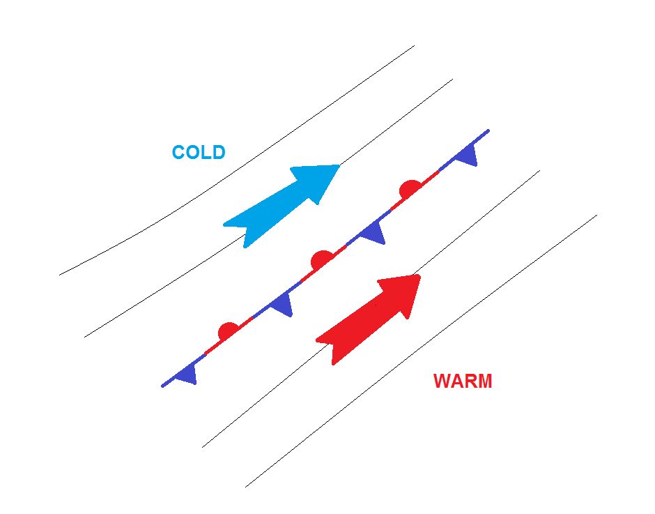
A pre-existing baroclinic boundary or slowly moving front separating colder from warmer air masses is a precondition for the development of a mid-latitude cyclone. On both sides, the air is moving parallel to the front; there is no temperature advection. A perturbation occurs at the intersection of the two air masses, causing a wave pattern to develop.
2. Wave Stage

Figure 2: Schematic of the surface fronts involved in a Shapiro-Keyser cyclone in the wave stage. Black lines depict the mean sea level pressure.
A surface low pressure starts building and a cyclonic circulation around the low starts to advect cold air to the south and warm air to the north (in the northern hemisphere). The so far stationary front organizes into a cold and a warm front. Up to now, there is no major difference between the Norwegian and the Shapiro-Keyser cyclone type.
3. Intensification Stage
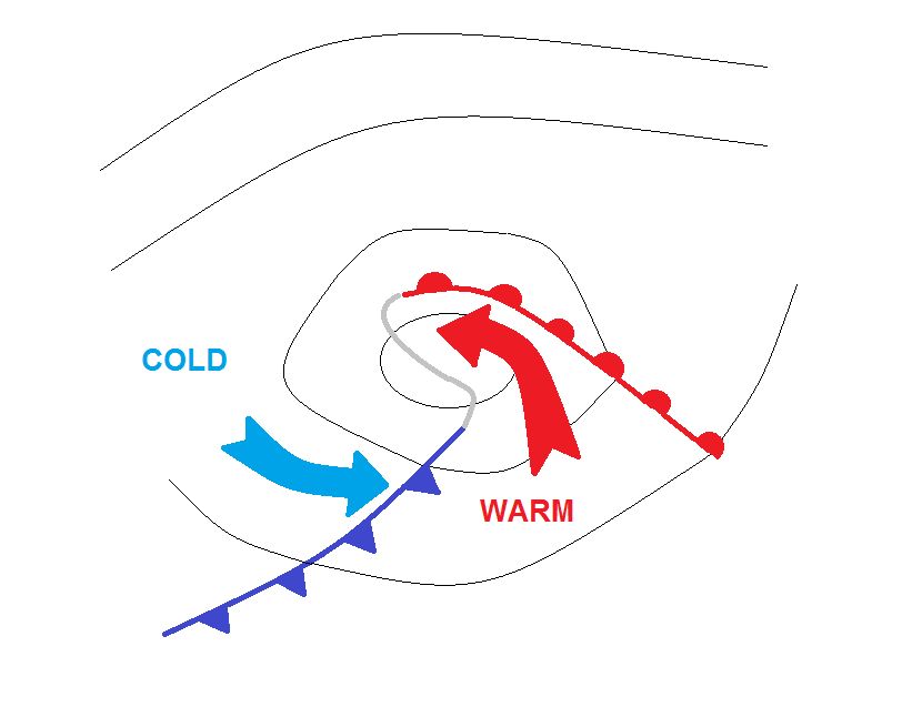
Figure 3: Schematic of the surface fronts involved in a Shapiro-Keyser cyclone in the intensification stage. Black lines depict the mean sea level pressure.
After the wave has formed, warm air continues protruding northward and starts filling the centre of the deepening low at lower levels (below ~700 hPa). The northern part of the warm front is stretched around the warm core of the Shapiro-Keyser cyclone. Although plotted as a warm front, its frontal characteristics only gradually show typical attributes of a warm front.
Cold air continues moving rapidly towards the southeast and the cold front detaches from the warm front (cold frontal fracture). In reality, the cold and warm front are still connected by an inactive air mass boundary that is usually not drawn on synoptic charts (grey line).
4. Mature Stage
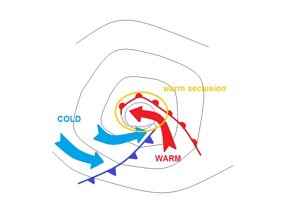
Figure 4: Schematic of the surface fronts involved in a Shapiro-Keyser cyclone in the mature stage. Black lines depict the mean sea level pressure.
Unlike the Norwegian cyclone type, no occlusion forms during the maturity stage of the Shapiro-Keyser cyclone. Instead, an air mass boundary delimits the warm core from the cold air in the north and the west of the surface low, showing many similarities to a warm front. In fact, where we would expect the occlusion on the synoptic chart, a bent-back warm front is drawn.
During maturity stage, cold air from behind the cold front starts wrapping around the warm core of the cyclone and forms a warm seclusion. The cold front successively approaches the warm front, forming the classical T-bone pattern often observed with Shapiro-Keyser cyclones.
5. Dissipation Stage
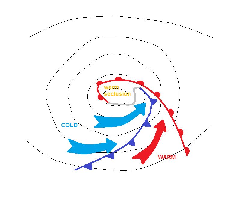
Figure 5: Schematic of the surface fronts involved in a Shapiro-Keyser cyclone in the dissipation stage. Black lines depict the mean sea level pressure.
In the final stage, the dissipating stage of the Shapiro-Keyser cyclone, cold air wraps around the warm core of the cyclone. The frontal gap closes and the cold front joins the warm front. The warm seclusion decouples from the warm sector while cold air from behind the cold front wraps around the warm core of the cyclone. The dissipation stage ends when a thermal equilibrium between the warm core and surrounding cold air is reached.
References
Schultz, D. M., D. Keyser, and L. F. Bosart, 1998: The effect of large-scale flow on low-level frontal structure and evolution in midlatitude cyclones. Monthly Weather Review, 126, 1767-1791.
Schultz, D. M. and H. Wernli, 2001: Determining Midlatitude Cyclone Structure and Evolution from the Upper-Level-Flow
http://www.cimms.ou.edu/~schultz/papers/marwealog.html
Shapiro, M. A., and D. Keyser, 1990: Fronts, jet streams and the tropopause. Extratropical Cyclones, The Erik Palmén Memorial Volume, C. W. Newton and E. O. Holopainen, Eds., Amer. Meteor. Soc., 167-191.
Young, M. V., 1995: Types of cyclogenesis. Images in Weather Forecasting, M. J. Bader, G. S. Forbes, J. R. Grant, R. B. E. Lilley, and A. J. Waters, Eds., Cambridge University Press, 213-286.