The classical "Polar Front Theory" - the classical "Norwegian Model"
The well-known polar front theory, after Bergeron, Bjerknes and Solberg, describes the development of extratropical, synoptic-scale low-pressure vortices, with their weather fronts "Cold Front", "Warm Front" and "Occlusion Front", from the early wave stage to the final occlusion spiral stage.
The idea behind this chapter is not to present the complex theoretical mathematical background but to describe the process that is the basis of several Conceptual Models in this Satellite Manual.
The polar front theory starts from an "Initial stage", which is the polar front: a boundary, or front, separating warm air to the south from cold air to the north. This air mass boundary is often stationary.
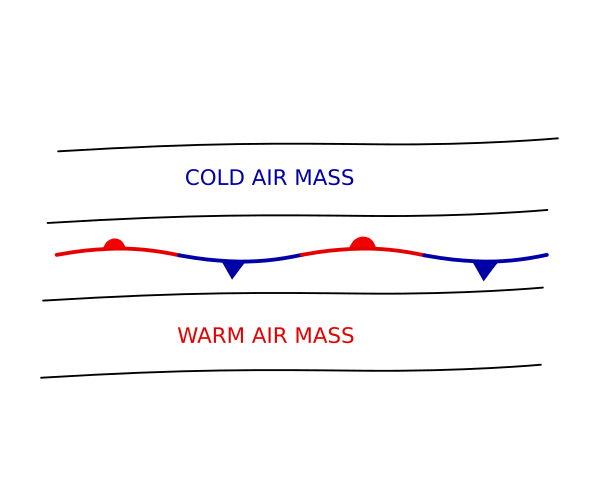
In this manual, the starting point is the satellite images; however, as the air mass boundary in the "Initial stage" is sometimes cloud-free or accompanied by randomly arranged cloud patches without any typical structure, this will not appear in any further schematics presented here. The schematics of the processes will therefore start from a wave stage where cloud systems have already developed that be seen as typical cloud structure in the satellite images.
Another starting point of a cyclogenesis process can often be found at the rear side of a well-developed cold front cloud band. This is called a Secondary cyclogenesis and it also starts with a cloud bulge representing the wave stage.
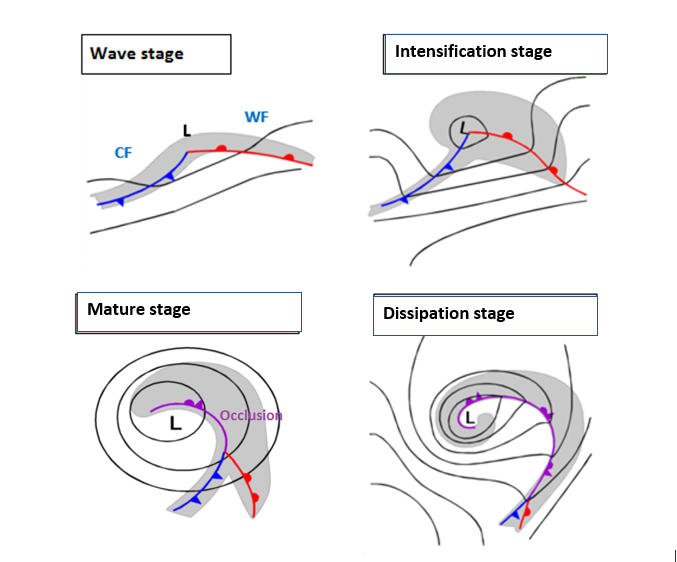
Figure 1: Four stages of the classical polar front theory. From a "Wave stage" to an "Occlusion stage".
A small-scale disturbance in the air stream can initiate a cyclogenesis process, which starts with the development of a low centre in low layers of the troposphere. Consequently, cold air starts move anticlockwise around a cyclonic low centre, pushing the cold air counter clockwise against the warm air. The cold air moves under the warm air, thereby lifting it. This leads to the development of weather fronts, which represent baroclinic boundaries. The upward vertical motion at these boundaries is responsible for the development of clouds, which form the cloud bands of "Cold Front" (CF) and "Warm Front" (WF) cloud bands. The area between CF and WF is called the "Warm Sector" (WS) since it contains the warmest air. At the same time a bulge of cloudiness develops around the low centre. This development stage is called the Wave Stage.
The Polar Front Theory further states that the Cold Front moves faster than the Warm Front, making the Warm Sector narrower while the bulge of cloudiness around the low centre becomes larger and thicker. This is the Intensification stage.
Later, the lifted warm air, as well as the connected cloud band, start to move around the low centre forming a cloud spiral. This is the Mature stage, with an occluded front and its accompanying occlusion cloud band. The centre of the surface low, which deepens during this development, remains on the cold side of the of the system.
Further development leads to the Dissipation stage, with an Occlusion cloud band that can spiral several times around the low centre, or with a comma configuration, which can be cut off in the centre of the low or with areas of reduced cloudiness mostly in the southern part of the occlusion spiral.
The Polar Front Theory (Norwegian model) was a fundamental breakthrough in meteorology. However, as it was based solely on surface observations, there were weaknesses in the theory:
- There is no physical mechanism for the growth of the initial perturbation.
- The faster movement of the cold air against the warm air is not always observed.
- The model does not describe any upper air phenomena.
- Not all cyclones can be described by the Polar Front Theory: they are more common in higher latitudes, where this theory was also developed.
More recently, advanced theories for cyclogenesis have been constructed as a result of improved observations and numerical modelling, alongside with the development of computers. Another model with frontal structure and development is the Shapiro-Keyser model.