The classical "Polar Front Theory" - the classical "Norwegian Model"
The well-known polar front theory after Bergeron, Bjerknes and Solberg describes the development of extratropical, synoptic scale low pressure vortices with their weather fronts "Cold Front", "Warm Front" and "Occlusion Front" from the early wave stage to the final Occlusion spiral stage.
The idea behind this chapter is not to present the complex theoretical mathematical background but to describe the process which is the basis for several Conceptual Models in this Satellite Manual.
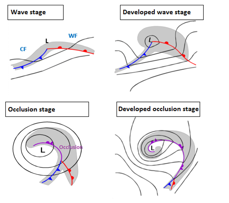
Figure 1: Four stages of the classical polar front theory
A small-scale disturbance in the air stream can initiate a cyclogenesis process which starts with the development of a low centre in low layers of the troposphere. Consequently, cold air starts to move counter clockwise against warm and the warm air counter clockwise against the cold air. The cold air is creeping below and thereby lifting the warm air, the warm air is upgliding on the cold air. This leads to the development of weather fronts which represent baroclinic boundaries. The upward vertical motions at these boundaries are responsible for the development of cloudiness and condensation and such the cloud bands of "Cold Front" (CF) and "Warm Front" (WF) appear. Between both fronts there is the warmest air which gives the name of "Warm Sector" (WS) to this area. Around the low centre a bulge of cloudiness develops. This development stage is called the "Wave Stage".
The Polar Front Theory further states that the Cold Front moves faster than the Warm Front which leads to the fact that the Warm Sector becomes more and more narrow and the bulge of cloudiness around the low centre becomes larger and thicker. This is called a "Developed Wave Stage".
As a consequence of the faster moving cold front, the cold air undercuts the warm air lifting it thereby and enhancing condensation.
At a later stage, the lifted warm air, as well as the connected cloud band, start to move around the low centre forming a cloud spiral. This is called the "Occlusion Stage" with an occluded front and its accompanying occlusion cloud band. A further development leads to a "developed Occlusion stage" with an Occlusion cloud band that can spiral several times around the low centre.
The Polar Front Model was a fundamental breakthrough in meteorology - but meanwhile some weaknesses of the theory appeared:
- The faster movement of the cold air against the warm air - as described by the Norwegian theory - cannot always be observed and satisfactorily explained
- The Norwegian cyclone model has been derived from surface observations only, upper air dynamics are not reflected satisfactorily
- Classical Polar Front Cyclones are more common in higher latitudes - where this theory was also developed
Consequently, alternative theories like the Shapiro-Keyser Theory for the development of synoptic scale cloud spirals around low pressure systems have been developed. They are - as satellite images have contributed a lot - mentioned in the CMs of this Satellite Manual.