Table of Contents
CAPE
An air parcel must have sufficient potential energy for convection. The indicator for this energy is CAPE - the Convective Available Potential Energy:
Hence, a key to the possibility for the growing of convective storms is the presence of CAPE, not the environmental lapse rates alone. Not all situations with conditional instability are characterised by air parcels with CAPE. Thus, the moisture content of the air is important for knowing whether conditional instability actually contains the potential for parcels to become buoyant. In that case, an external source of energy must be supplied to the air mass to convert its potential instability into actual instability and lift the parcel through its condensation level to its Level of Free Convection (LFC) - that means, for instance, the change from potential instability to conditional instability. The amount of this supplied energy is known as the Convective Inhibition (CIN).
From the LFC to the Equilibrium Level (EL), the parcel accelerates vertically, drawing the energy for this acceleration from the CAPE.
Convective Available Potential Energy
All levels of sounding or pseudotemp are used for the calculation of CAPE. The unit of CAPE is J/kg and it describes the maximum amount of potential energy which the air parcel has available for convection. CAPE is calculated by integrating over height the (virtual) temperature difference of lifted air parcel and the environment. In a thermodynamic diagram this represents the area that is between the curve of lifted air parcel and that of the environment. The integration normally is started from level of free convection (LFC) which is the level above which the lifted parcel is warmer than environment. The upper limit for the integration is the level of neutral buoyancy (LNB) in which the parcel and environment curves meet again.
The formula for CAPE is as follows:
where g= acceleration by gravity, z = height (m), T'v = virtual temperature of the air parcel and Tv = virtual temperature of the environment. CAPE can also be calculated using temperatures instead of virtual temperature. Also pressure coordinates can be used instead of height coordinates.
CAPE values in pre-thunder conditions range from a few hundreds of J/kg up to thousands of J/kg. The greatest observed values are of the order of 5000-7000 J/kg. The definition of CAPE doesn't take into account the existence of entrainment, liquid water loading, aerodynamical effects or the vertical motions in the environment, which have a decreasing effect on the value of CAPE.
CAPE can also be calculated with starting integration level not being the LFC, but instead, either a fixed level (e.g. 850 hPa), a lifted condensation level (LCL) or a convective condensation level (CCL).
|
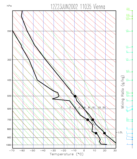
23 June 2002/12.00 UTC - Radiosounding Vienna; black: temperature and dew-point, green: path of a lifted parcel from surface. The area denoted by dashed green lines represents the amount of CAPE.
|

|
The example below shows the distribution of CAPE associated with the different types of instability.
|
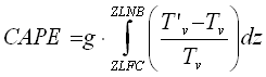
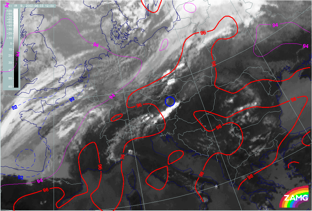
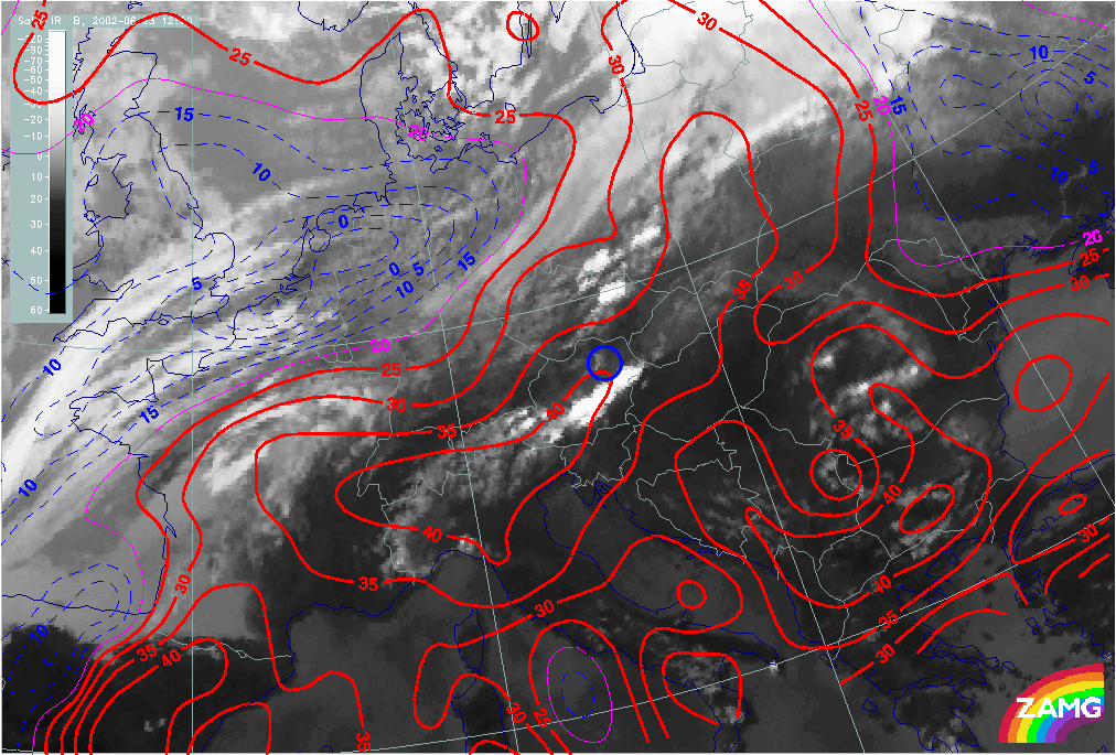
23 June 2002/12.00 UTC - Meteosat WV image; red: Isolines of CAPE >= 600 units/40 units; position of sounding from Budapest (12843) indicated
|
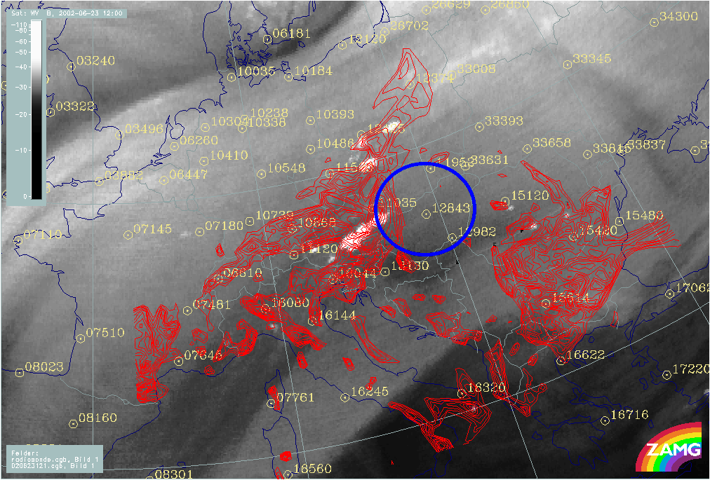
23 June 2002/12.00 UTC - Meteosat VIS image; red: Isolines of CAPE >= 600 units/40 units; position of sounding from Budapest (12843) indicated
|
|
|
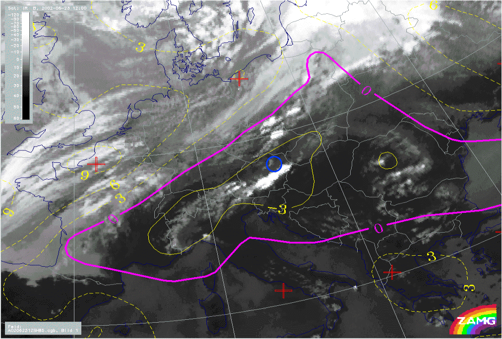
The left image above shows the WV channel on the 23rd June 2002 at 12.00 UTC. There is distinct DMC over Austria and weak DMC beginning over the Carpatian region. Whereas there seems to be no significant deep convection over Hungary. The right image shows the VS channel at the same time.
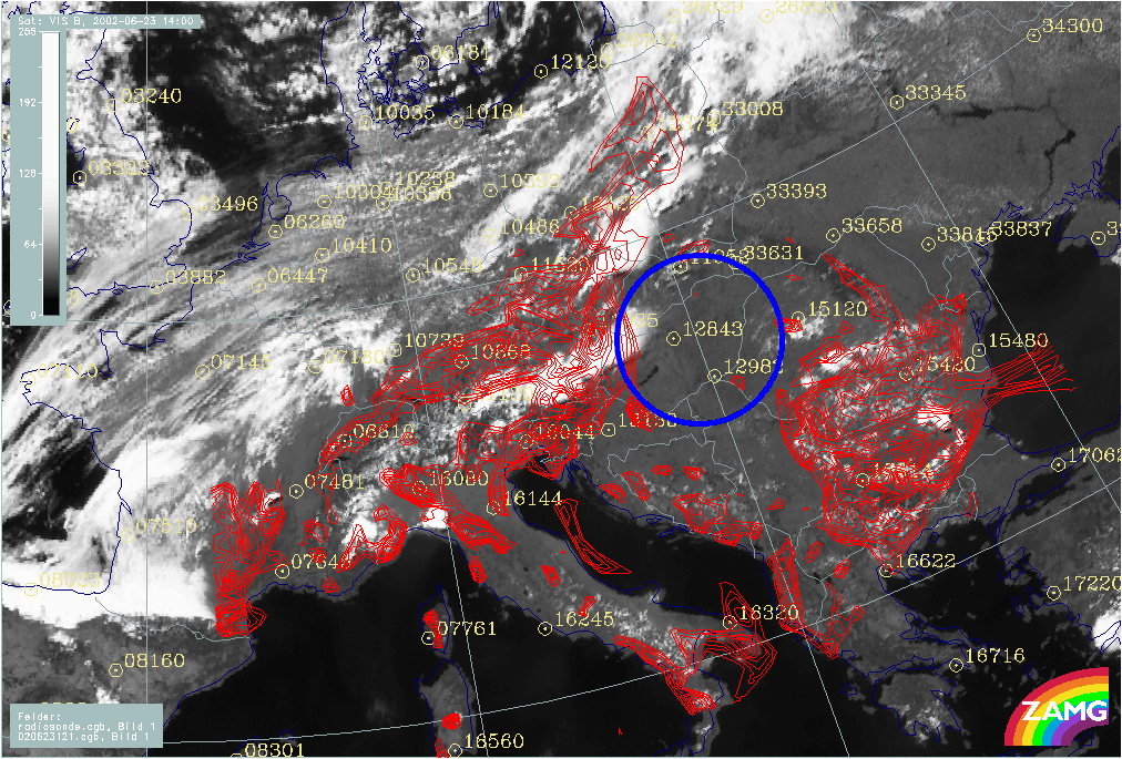
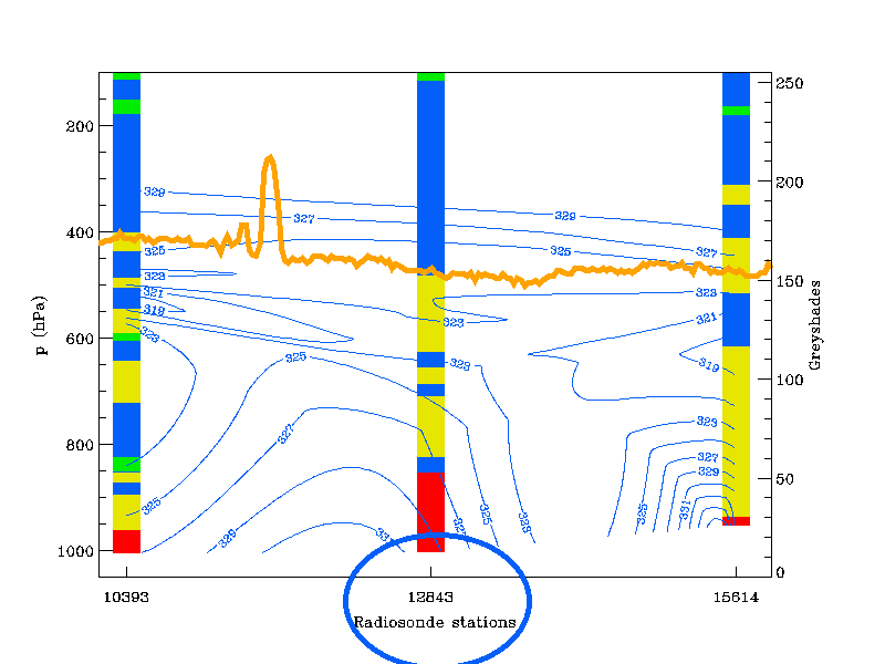
The red isolines represent CAPE for 12.00 UTC derived from the ALADIN model >= 600 units. Intense DMC is associated with higher values of CAPE. In the images below a vertical cross section is indicated (left) which includes three radio soundings; the vertical distribution of derived equivalent potential temperature, interpolated from the radio soundings is shown on the right). Station 12843 (Budapest) shows a significant amount of conditional instability up to 500 hPa (some flat stable layers included) and a weak decrease of ThetaE around 500 hPa. But there is no convective activity so far (12.00 UTC), despite the amount of conditional instability. It can be clearly seen in the images above that there is not sufficient CAPE in the vicinity of Budapest, therefore there is insufficient energy for lifting the air to condensation level and further to the LCL. The CIN could not be overcome by the CAPE in this area.
|
23 June 2002/12.00 UTC - Meteosat WV image; position of vertical cross section and sounding from Budapest (12843) indicated
|
23 June 2002/12.00 UTC - Vertical cross section; blue: equivalent potential temperature, stability analysis, position of sounding from Budapest (12843) indicated
|
|
|
Stability indices
Stability indices are a group of indices that have been developed to illustrate the potential for convection within an air mass based upon a radiosonde or model derived sounding. In most cases stability indices are derived from the temperature and humidity data of the sounding at certain fixed levels. Some stability indices even use information from all observed levels of the sounding (such as CAPE, see previous chapter). Some indices even contain a contribution of wind information.
All indices, however, eventually give only one numerical value (which may be dimensionless). This value represents the potential for convection at a certain fixed location (either the radio sounding site, if the index calculated from radio sounding data or a numerical model grid point, if numerical data used for calculation). The value of the stability index is compared to some statistical threshold value differentiating e.g. non-thunderstorm and thunder storm cases.
For air mass classification purposes index values are plotted and analysed on a weather map, preferably with a suitable satellite underlay image. This latter method is particularly effective for model derived stability indices, since model derived soundings can be calculated at each model grid point for each model time step.
In meteorologiy, the use of convection indices varies from country to country, reflecting different methods, but also the different climatologies. A full list of indices used would contain tens of different indices and would go beyond the scope of this manual. For this reason only a small selection of stability indices - containing those used in this manual - is presented in this chapter.
Showalter Index (SI)
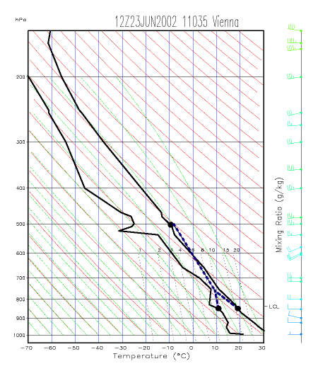
Showalter index is calculated using temperature and dew point at 850 hPa and temperature at 500 hPa. The method is as follows: air parcel is lifted dry-adiabatically from 850 hPa level to the lifted condensation level (LCL) and from LCL up to 500 hPa moist-adiabatically. The result T'850->500 is subtracted from the actual 500 hPa temperature T500:
|
23 June 2002/12.00 UTC - Radiosounding Vienna; The black dots denote the critical levels used for the calculation of Showalter index. The blue dashed line represents the path of lifted air parcel from 850 hPa to 500 hPa.
|
23 June 2002/12.00 UTC - Meteosat IR image; yellow, magenta: Showalter index, position of radiosounding Vienna indicated
|
|
|
The Showalter index in this case shows large negative values over Central Europe, within the warm airmass. The larger the negative values, the larger the instability. Threshold values for thunderstorms vary, but generally values lower than +3 already indicate a possibility for thunderstorms, values lower than -3 the possibility for heavy thunderstorms.
Boyden Index (BI)
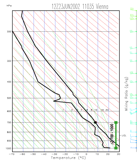
The Boyden index has been developed to allow better diagnosis of frontal thunderstorms. No humidity information is included in the calculation. The index is calculated using the following formula:
in which Z700-1000 is the thickness of the layer between 700 and 1000 hPa in decametres, T700 the temperature (in degrees Celsius) at 700 hPa. Scaling factor 200 is used to bring the absolute values of the Boyden index close to a range from 90 to 100. Since the index doesn't contain surface temperature information, there is little variation between continental and marine air masses. The diurnal variation is also small. The higher the value of the Boyden index, the greater the risk of thunderstorm. The threshold value is approximately 95.
|
23 June 2002/12.00 UTC - Radiosounding Vienna; The critical levels for the calculation of Boyden index are shown as black dots (denoting 700 hPa temperature) and green line (denoting the thickness between 700 and 1000 hPa).
|
23 June 2002/12.00 UTC - Meteosat IR image; blue: Boyden index < 92, magenta: Boyden index = 94, red: Boyden index > 96, position of radiosounding Vienna indicated
|
|
|
K-Index (KI)
George's K-Index takes into account three components important for convective instability: temperature lapse rate, lower tropospheric humidity and the vertical extent of the humid layer. The index is calculated as follows:
where T850=temperature at 850 hPa, T500 = temperature at 500 hPa, Td850 = dewpoint at 850 hPa, T700 = temperature at 700 hPa and Td700 = dewpoint at 700 hPa. Temperatures are given as degrees Celsius.
A K-Index lower than 20 indicates zero likelihood of thunderstorms, while K-index value higher than 35 indicates likelihood of numerous thunderstorms. As the lapse rate in a cold air mass differs from that in a warm air mass by several degrees, definitive threshold values for K-index are difficult to calculate.
|
23 June 2002/12.00 UTC - Radiosounding Vienna; The critical levels for the calculation of K-index are shown as black dots.
|
23 June 2002/12.00 UTC - Meteosat IR image; blue: K-index < 15, magenta: K-index = 20, red: K-index > 25, position of radiosounding Vienna indicated
|
|
|
Convection and instability
The physical concepts behind synoptic - and/or mesoscale cloud configurations in satellite images can be well described using hydrodynamic, quasigeostrophic theory with help of parameters such as temperature advection, vorticity advection and many others. For small scale cloud features, like convective cells, the hydrostatic point of view is more important.
Large scale areas often contain synoptic conditions suitable for the development of convection, however, convective features are much smaller scale. The concept of a buoyant air parcel is best understood using hydrostatic information describing the state of the air column above. Information about the quality of an air column can be gained from radio soundings or with model derived soundings (e.g. from a LAM model like ALADIN or HIRLAM). Consequently, for single CB's and MCS's other parameters and their vertical distribution become more important than those commonly associated with larger scale conceptual models.
Atmospheric conditions for convection
Convection in general is mass motion within a fluid resulting in transport and turbulent mixing of the properties of that fluid by vertical movement, in matters of transport of energy (heat), water vapour and momentum. As such, it is one of the three main processes by which energy (heat) can be transported vertically: radiation, conduction, and convection.
Meteorologists typically use the term convection to refer to heat transport by the vertical component of the flow associated with an updraft. Convection is best explained by the so-called lifted parcel theory. Here, the environment of the parcel is not affected by this displacement, and the upward force affecting such a rising plume (i.e. parcel) of air is buoyancy, which is defined by
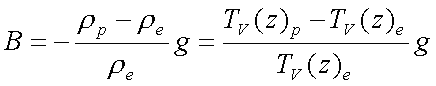
The difference in density (left term) or in virtual temperature (right term) between the rising parcel (p) and the parcel environment (e) causes the updraft. Consequently, a parcel with greater temperature and less density will be controlled by buoyancy and displaced vertically. The virtual temperature is conservative in association with the moisture within the parcel. Vertically integrated the right term in the buoyancy formula gives the amount of available convective energy (see Numerical Parameters for Small Scale Convective Cloud Systems - Cape). It is clear that the vertical displacement and acceleration of an air parcel is directly associated to buoyancy.
Atmospheric convection is nearly always turbulent and it can take many modifications in the atmosphere:
- Dry thermals, which do not reach their level of saturation. Mostly in the boundary layer convection is dry with relative humidities less than 100%. In this case there is no cloud formation and therefore those turbulent plumes can not be seen in the satellite images.
- Buoyant plumes of moist warm air, reaching the saturation level and forming visible cumuliform clouds. Depending on the conditions of the atmosphere they might grow into severe convective weather events (thunderstorms resulting in large hail, damaging wind gusts, tornadoes, and heavy rainfall) which are generally the result of released energy by phase changes of water.
During the condensation latent heat energy is released and additionally contributes to buoyancy. Most of the energy is expended against gravity, but the remaining portion of available energy is responsible for the severity of the convective weather event.
The vertical transport of moisture through convection above levels of 600 hPa can be seen in the WV image. The term convection, commonly associated with this type, is henceforth referred to as deep moist convection (DMC). Shallow convection with less vertical extent can be observed earlier in the VIS and the IR channel.
2 main types of convection can be distinguished:
- Free convection (also called gravitational or buoyant convection): motions that are predominantly vertical and driven by buoyancy forces arising from hydrostatic instability, with locally significant deviations from hydrostatic equilibrium. Free convection can mostly be related to diabatic heating through insolation (short wave radiation) on surfaces with higher heat capacity than the neighbouring environment or thermal forcing through greater diabatic heating at elevated surfaces.
- Forced convection: motion induced by mechanical forces such as deflection by a large scale surface irregularity, turbulent flow caused by friction at the boundary of a fluid, or motion caused by any applied pressure gradient. Furthermore this type of convection is caused by lifting owing to dynamical convergence, lifting through orography, lifting within the lee circulation of a mountain ridge or gravity waves.
The unstable stratification of the atmosphere is the cause of deep moist convection, whatever the reason may be for convective initiation or the type of appearance of convective cells. Therefore the different types of instability are now considered further:
Convection and Instability
The origin of instability is heat, both latent and sensible, that is produced as a result of solar heating and evapotranspiration of water vapour (also due to solar heating) in the lower troposphere. Convection transports the excess sensible heat and water vapour from low levels into the upper troposphere, and transports cooler, dry air downward, thereby reducing the instability. Thus the instability is initiating DMC, but convection will only continue until the instability is removed.
Hydrostatic stability is a state variable for the stratification of the atmosphere or at least of a column of air. It can be indicated by various variables like temperature, humidity or density. The change, usually a decrease of those parameters, is shown in the lapse rate. In the hydrostatic approach the process lapse rate is distinguished from the environmental lapse rate of the lifted air parcel. For parcel theory, the term "environment" means the immediate vicinity to the parcel. This environment is not affected by the processes applied to the parcel.
The dry adiabatic lapse rate of an air parcel is the rate of decrease of temperature with height of a parcel of dry air which is lifted through the atmosphere in hydrostatic equilibrium. That means if a parcel of air is vertically displaced without saturation its temperature will change with the amount of Γ
During the process of lifting an air parcel will cool and may reach the point of saturation. If it is still buoyant and continuing its ascent, its temperature will decrease moist adiabatically. The moist adiabatic lapse rate is smaller because of the release of latent heat through condensation:

where
The process lapse rate is
 . The relation between γ and Γ/Γm is the degree for stability:
The temperature T is dependent on changes of pressure and moisture during the lifting process. Therefore the potential temperature Θ is defined, which is unchanged with adiabatic changes of pressure and thus conservative when associated with the vertical pressure gradient:
According to adiabatic processes the equivalent potential temperature Θe is conservative associated to the vertical pressure gradient and saturation:

According to the formula above it can be seen that Θ increases with height in an air column within hydrodynamic equilibrium and also Θe increases with height on a slightly different rate. The stability of the vertical stratification can be directly derived from the vertical gradient of Θ and Θe. A decrease of Θe then causes vertical acceleration of the air parcel due to instability.


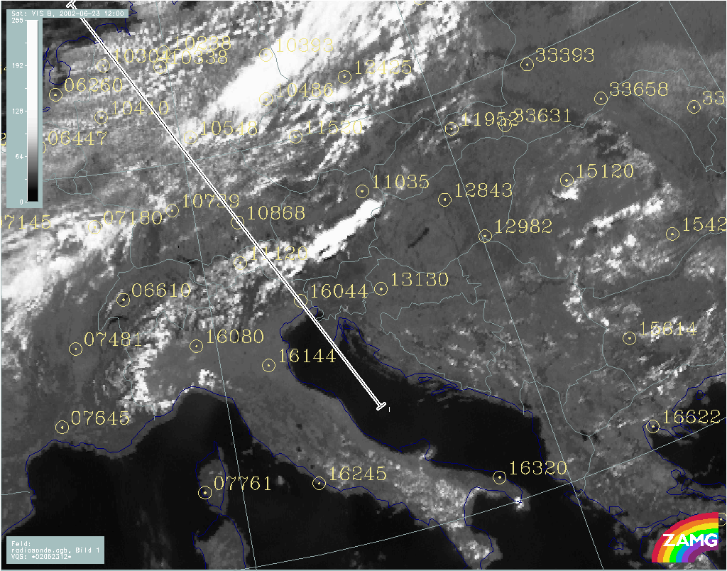
The example of the 23rd June 2002 at 12.00 UTC (VIS image below) shows a situation with an MCS over Austria, a Cold Front over northern Europe and cold air cloud features over Northern Germany. The position of a vertical cross section and the major European radiosonde stations are indicated.
|
23 June 2002/12.00 UTC - Meteosat VIS image; yellow: numbers of stations with radiosoundings; position of vertical cross section indicated
|
|
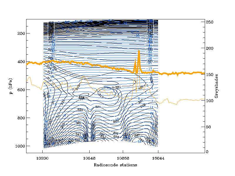
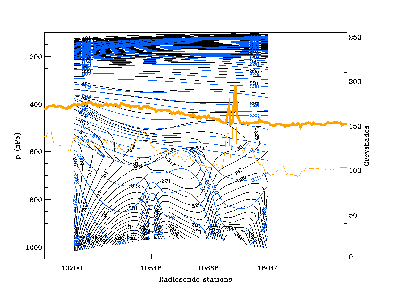
The two images below show the associated cross section. The vertical distribution of equivalent potential temperature Θe (black) and temperature T (blue) can be seen in the left image, the vertical distribution between the equivalent potential temperature Θe (black) and potential temperature Θ (blue) can be seen in the right image. The isolines are derived from interpolation from radio soundings of the 23 June 2002 12.00 UTC. The orange lines indicate IR (thin) and WV (bold) pixel values. The peak between the stations 10868 and 16044 represents the convective cell seen in the VIS image above.
|
23 June 2002/12.00 UTC - Vertical cross section; blue: temperature (derived from radiosoundings), black: isentropes (ThetaE), orange thin: IR pixel values, orange thick: WV pixel values
|
23 June 2002/12.00 UTC - Vertical cross section; blue: potential temperature (derived from radiosoundings), black: isentropes (ThetaE), orange thin: IR pixel values, orange thick: WV pixel values
|
|
|
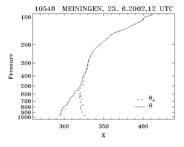
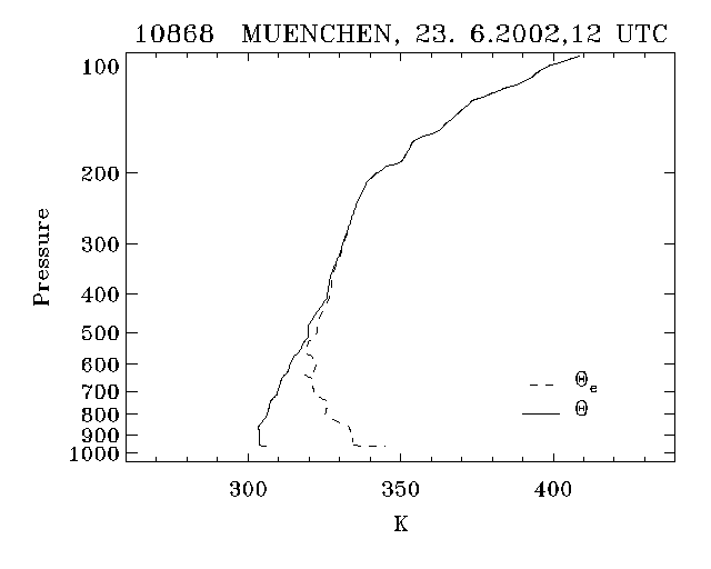
Around the station 10868 Munich, which is in the vicinity of the convective cell, a significant decrease of Θe is detected while there is no change in the stratification of T and Θ. Observing the vertical distribution of Θ and Θe in more detail, the right image above shows a steep decline of Θ (blue) around the station 10548 Meiningen and 10868 Munich but no decrease. The decrease of the equivalent potential temperature Θe (black) is very weak at Meiningen which is the station more to the north. While Munich clearly shows a decrease of Θe up to 600 hPa, indicating unstable stratification. The difference in the vertical gradient of the equivalent potential temperature between the two stations can also be seen in the two plots below.
|
23 June 2002/12.00 UTC - Radiosounding Meiningen (10548); black: solid: potential temperature lapse rate, dotted: equivalent potential temperature (ThetaE) lapse rate
|
23 June 2002/12.00 UTC - Radiosounding Munich (10868); black: solid: potential temperature lapse rate, dotted: equivalent potential temperature (ThetaE) lapse rate
|
|
|
The following constructions on a tephigram (thermodynamical diagram) illustrate thermodynamic variables based on a parcel of air at 850 hPa with a given temperature, wet-bulb temperature and dew point. Formerly used variables like potential and equivalent temperatures can be obtained from the diagram.

Different kinds of instability can be distinguished:
Absolutely stable
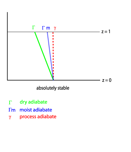
An air parcel has the same temperature or is colder as its environment. Therefore there will be no lifting force on that parcel.
Absolutely unstable
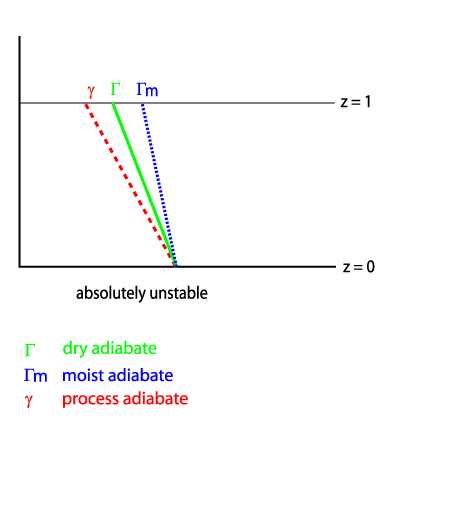
The state of a column of air in the atmosphere when the lapse rate of temperature is greater than the dry-adiabatic lapse rate. The temperature of the air parcel is warmer than its environment, thus the parcel will be buoyant and will rise further. An air parcel vertically displaced is accelerated in the direction of the displacement and the kinetic energy consequently grows with the increasing distance from its level of origin.
Potentially (convectively, thermally) unstable

This condition represents the state of a humid but unsaturated parcel of air with an equivalent-potential - temperature that decreases with height. That means that air parcel motion is stable with respect to unsaturated vertical displacements and unstable with respect to saturated vertical displacements. The lapse rate in this layer steepens to a rate greater than the pseudo-moist adiabatic lapse rate (pseudo-moist is moist adiabatic without its liquid water content). If such a column is lifted until completely saturated, it will become unstable regardless of its initial stratification. Its lapse rate will then exceed the moist adiabatic lapse rate.
The decrease of potential temperature with height as such is a sign for absolute instability. A column of air is potentially unstable when the equivalent potential temperature is decreasing even if there is an increase of potential temperature. But potential instability as such is not necessarily the cause of strong convective development and heavy thunderstorm activity. The probability for severe weather and storms rises if the air parcel reaches saturation and additional latent heat is released supporting the lift. This situation is then called:
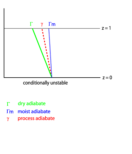
Conditionally unstable

The atmosphere is said to be conditionally unstable where the environmental lapse rate is greater than the pseudo-moist adiabatic lapse rate, but less than the dry - adiabatic lapse rate. The condition for instability when Γ > γ > Γm is that the air parcel is saturated.
When the environmental lapse rate is greater than Γ, an air parcel is unstable whether or not it is saturated. If the environmental lapse rate is less than pseudomoist adiabatic, the atmosphere is conditionally stable. If γ = Γm the atmosphere is neutral with respect to saturated vertical displacements.
According to the saturation the equivalent potential temperature Θe has to be replaced by Θes which is the saturation equivalent potential temperature. It is the equivalent potential temperature an air parcel at the same pressure and temperature would have when it is saturated.
Short discussion of the difference between potentially unstable and conditionally unstable
An upward decrease of Θe (potentially unstable) implies conditional instability, too, but if there is no saturation the layer of air might remain potentially unstable. Since Θe is not a state variable for unsaturated air unless completely saturated, the air can be potentially unstable, neutral or quite stable, when Θe decreases upward. When the parcel is lifted until saturation, the decrease of Θe is changed into a decrease of Θes. When the air is not completely saturated, Θes is not conserved. But when the air is saturated and Θes = Θe, both are conserved. At this point during the lifting process the air mass becomes more unstable due to the additional release of latent heat: strong convective developments are highly probable. In other words: only if the vertical displacement is sufficient enough and a potentially unstable layer or parcel is lifted to saturation it will become conditionally unstable.
|
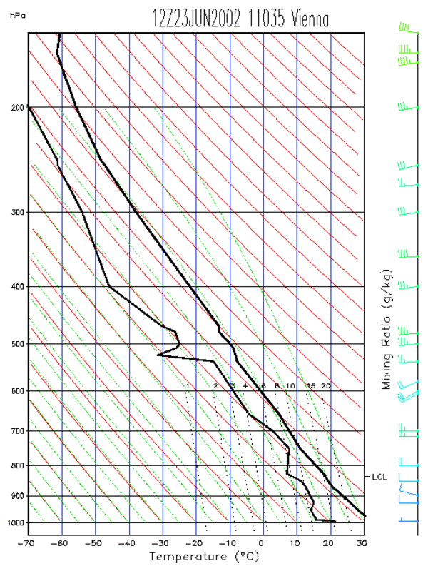
23 June 2002/12.00 UTC - Tephigramm Radiosounding Vienna (11035)
|
|
|
|
|
|
|
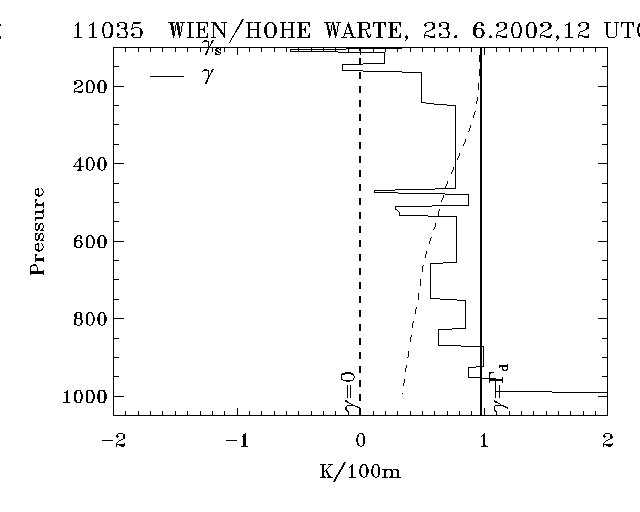
23 June 2002/12.00 UTC - Radiosounding Vienna (11035); black: distribution of lapse rates
|
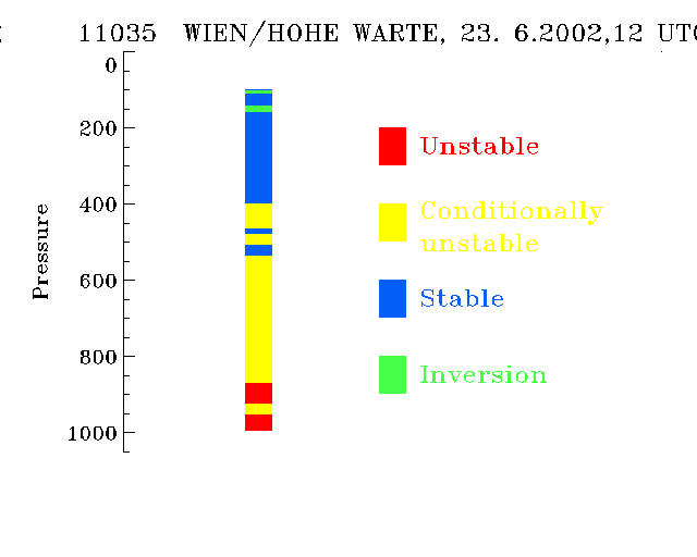
23 June 2002/12.00 UTC - Radiosounding Vienna (11035); stability analysis
|
The sounding of Vienna 020623 at 12.00 UTC shows the distribution of lapse rates (above left) and stability analysis (above right): absolute instability up to about 950 hPa, and conditional instability from about 950 to 500 hPa. Also the decrease of equivalent potential temperature within the layer up to 500 hPa can be seen in the diagram below left indicating potentially unstable stratification. The satellite image below right shows a convective cell in the immediate vicinity of the station.
|
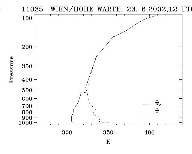
23 June 2002/12.00 UTC - Radiosounding Vienna (11035); black: solid: potential temperature lapse rate, dotted: equivalent potential temperature (ThetaE) lapse rate
|
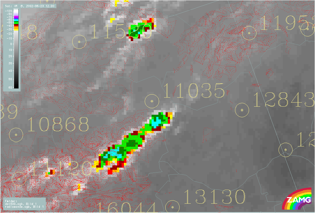
23 June 2002/12.00 UTC - Meteosat IR enhanced image; yellow: radiosonde stations
|
|
|
The sounding of Vienna 020623 at 12.00 UTC shows the decrease of equivalent potential temperature within the layer up to 500 hPa. A convective cell can be seen in the immediate vicinity of the station.
Other kinds of instability
Buoyantly unstable:
This kind of instability is more important when associated with gravity waves and hydrodynamic instability. It is mentioned at this point for the sake of completeness. Here buoyancy is the only restoring force on displacements. When lifting dry-adiabatically the air parcel requires the lapse rate of temperature greater than the adiabatic lapse rate. Also the environmental lapse rate of density is grater than the process density lapse rate. Since the vertical acceleration is zero in a hydrostatic atmosphere, buoyancy is associated with an unbalanced pressure gradient force, mostly caused by density perturbations.
Change in Stability
Horizontal advection of parameters like temperature, density and relative humidity are able to change the state and type of instability. Typical vertical distributions for the tendency of stabilisation or labilisation are well defined and can be observed in radio soundings and model derived soundings. The horizontal advection can be seen in the vertical distribution of the wind field. Also differences in strength and direction are responsible for convective development and type of convection (single cells, super cells, squall lines, organised convection). Curves describing the vertical change of the wind direction are called "Hodographs". The schematic below describes all possible vertical wind distributions associated with the effects of stabilisation or labilisation of a layer of air.
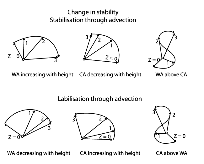
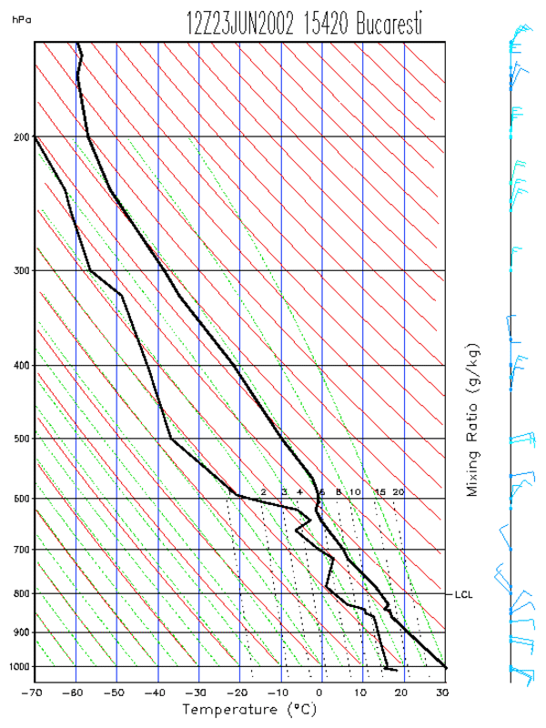
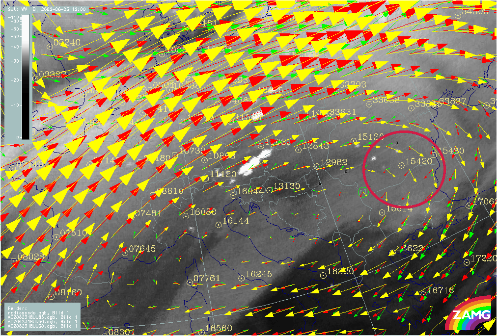
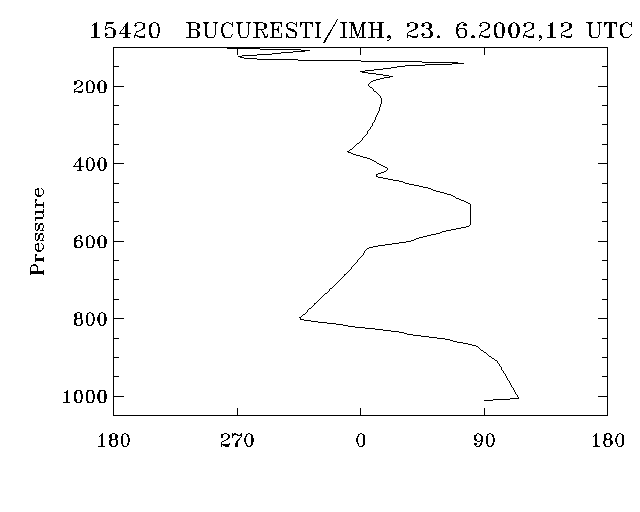
The example below shows the case of 23rd June 2002. In the left image the WV channel shows deep convection in the area next to Bucaresti/Bulgaria. Arrows indicate the wind fields at different heights of the ECMWF model (left image, 2nd row below). Those are reflecting well the observed radio sounding (Tephigram of sounding below, karthesian plot of wind directions 2nd row below, right image). From levels above 800 hPa, the sounding shows CA above WA which results in an advective labilisation tendency.
|
23 June 2002/12.00 UTC - Tephigramm Radiosounding Bucharest (15420)
|
|
|
|
|
|
|
23 June 2002/12.00 UTC - Meteosat IR enhanced image; yellow: wind vectors 300 hPa, red: wind vectors 500 hPa, green: wind vectors 850 hPa, position of Bucharest radiosonde station (15420) indicated
|
23 June 2002/12.00 UTC - Radiosounding Bucharest (15420); black: wind direction
|
Entrainment
Most convective clouds are driven by positive buoyancy, with virtual temperature greater than the environment, but clouds with precipitation, evaporation, and/or melting can produce negatively buoyant convection. If there is not sufficient moisture in lower levels, low moisture content in upper levels will cause too much evaporation and therefore negative buoyancy.
Evaporation is also caused through turbulent entrainment of dry air into a Cumulonimbus cloud. That means if there is insufficient moisture in the lower levels to be lifted to saturation a growing CB might "dry out" through entrainment. Here evaporation leads to a cooling of the rising air parcel and thus to negative (downward) buoyancy and consequently stops or hinders DMC.