Training Module


The Xynthia Storm by ASCAT
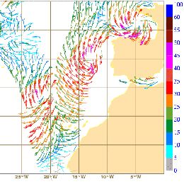
This case study covers the development of storm Xynthia. Xynthia evolved out of a low pressure system which formed east of the Bermuda and lasted for 8 days. The storm was well depicted in satellite imagery and showed strong convective activity over the Atlantic. When approaching Western Europe and crossing Northern Europe, Xynthia was mainly a windstorm with gusts exceeding 150 km/h. The module briefly describes the functional principle of the ASCAT sensor and illustrates how measurement is performed and wind speed is retrieved. A comparison of ASCAT winds with NWP and surface winds is given, showing the benefits and drawbacks of each data source. Chapter 2 of the case study investigates the storms life cycle. In combination with satellite images, ASCAT wind data are plotted revealing deeper insight into the wind circulation close to ocean surface. The detailed analysis of the wind fields shows additional information on the position of the surface fronts and the location of pressure minima. Ongoing measurements of wind speed and direction from ASCAT is compared with NWP data and surface observations. The life cycle of storm Xynthia, from its real beginning over the Atlantic until its filling over the North Sea, is followed. During this time, Xynthia was covered 8 times by overpasses of the ASCAT sensor. Chapter 4 allows the user to combine satellite images, ASCAT data and NWP prognostic data in the ePort environment for 6 time steps within storm Xynthia´s life cycle.
Filed under Keywords:
ASCAT, storm, sea waves, scatterometer, NWP, MetOp-A