Webcast

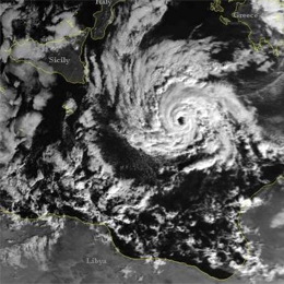
Rapid Cyclogenesis or Medicane
This case study took place in Mediterranean basin from 7th to 8th November 2011, with some interesting weather phenomena occurred there. It is shown that the sequential cloudiness type bands were; not organized convective system in the first step, then Comma feature in the next step, deep convection and finally occlusion. Because of confusing weather features connected to it, this weather phenomenon can not be classified as Tropical Cyclone nor as Rapid Cyclogenesis. The case is treated only from a synoptic point of view, using Meteosat-9 satellite images and ECMWF numerical fields from ePort web site and other graphical elaborations with Metview.
Filed under Keywords:
Conceptual Models, Synoptic Scale Meteorology, Frontal Structures, Frontal Substructures, Convection, Cold Air Outbreak, Medicanes

