Webcast


Anticipated benefits of improved temporal and spatial resolution
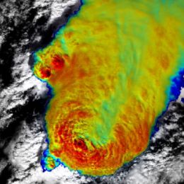
The presentation addresses some of the general impacts of the higher temporal and spatial resolution, available with the most recent or upcoming geostationary weather satellites. Main contribution of the higher scan frequency (of the order of 2.5 minutes or shorter) is in much better temporal coverage of evolution of rapidly developing weather systems, namely those associated with deep convection. The impact of shorter scan frequency will be demonstrated using data from the MSG 2.5-minute experiment. Spatial resolution affects not only the fidelity of imagery, but also (and more importantly) some of the quantitative characteristics of cloud tops - such as local cloud top brightness temperature minima, associated with overshooting tops. This effect will be demonstrated using high resolution polar satellite imagery.
Filed under Keywords:
MTG, image resolution, rapid scan