Webcast


New capabilities with high resolution cloud micro-structure facilitated by MTG 2.3 um channel
Major advancements of the MTG with respect to MSG are the superior resolution and the added 2.3 um channel, which in combination allow
retrieving cloud particle effective radius and discerning cloud phase at the very high resolution of 500 m. These cloud properties determine
whether a cloud would be precipitating, and if so whether it would be rain or snow. This information is particularly advantageous for observing
small boundary layer clouds, which often produce rain showers in very clean air masses, such as at the Atlantic coast, but stop raining when
polluted inland. This is also the case for post frontal clouds that may produce snow showers. It will be possible to detect it with the MTG.
The ability of retrieving high resolution cloud drop effective radius in convective clouds makes it possible to retrieve cloud drop concentrations,
which are dominated by aerosol particle concentrations. The retrieved cloud drop concentrations can be reversed to infer the concentrations of
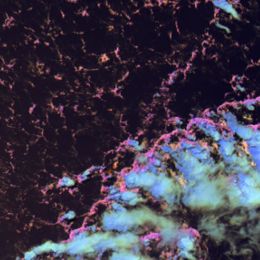
particulate air pollution that occur under cloud decks that are rooted in the boundary layer. A proxy to the retrievals is an RGB color combination
that can show the same qualitatively.
Furthermore, the inferred cloud drop concentrations has a predictive value for the nature of foretasted convective storms in that air mass, because
the aerosols can invigorate the storms and make them more prone to producing lightning and hail.
Filed under Keywords:
MTG, precipitation, cloud drop effective radius, RGB