Webcast
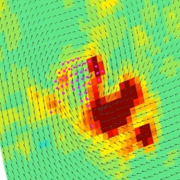


Sea Surface Wind Vectors
The lecture deals with modelled winds and winds derived from instruments onboard satellites like Metop-A and Metop-B in low orbits around the
Earth (polar orbits). Today's models are evolving at a rate that is faster than the increase of density of observations and that presents a problem
for forecasts. Here stands the question 'Will meteorology continue to develop and improve?'. The lack of observed data is thus filled with the data
from satellites, although this data also has its own constraints due to the way it is derived. In the lecture the characteristics of the satellites
carrying instruments for measuring winds and waves will be explained and the logic behind the calculations of winds using satellites will be
discussed.
Scatterometer data are used for many different purposes in marine meteorology, e.g. warnings, enhancement of situational awareness for winds,
monitoring of storm evolution, low pressure systems, etc., therefore marine forecasters using the products about wind and waves from satellites
will be instructed how to use them and when to combine the data with model outputs.