Case Study


Formation of a Squall Line over Germany
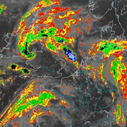
During the 18th August a frontal cloud pattern moved from Western France to Central Germany. From noon until the evening this cloud pattern transformed into a squall line due to cyclonic vorticity advection induced by a short wave trough. From the afternoon to the evening a mesoscale low with negative surface pressure tendencies developed east of the squall line. In combination with the increasing temperature contrast between the front and rear of the squall line, the velocity of the wind reached 100 km/h. Gusts of up to Beaufort 9 (flat areas) and 11 (mountainous regions) and precipitation of about 30 mm over Eastern France and and Western Germany were observed.
Filed under Keywords:
Squall Line, Convection, Windburst, Convection