Case Study


Cold Front over Middle Europe
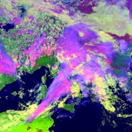
This case study follows a cold front propagating from the Atlantic towards eastern Europe at the leading side of a deepening upper level trough. Special attention is paid to two waves developing on the cold front. Both of them show similar phases of development, from the first appearance of a cloud bulge to the formation of a cloud spiral.
The whole process can be observed in several types of satellite images: IR, WV and Airmass RGB composite. In the IR images the formation of the both wave bulges, intensification of the frontal cloudiness and cloud spiral development can be followed. The WV images enable the detection of the jet and the intrusion of dry stratospheric air. In the Airmass RGB the different air mass types as well as the position of the jet stream can be detected.
Filed under Keywords:
Cold Front, Upper Level Low, Wave, Synoptic Scale Meteorology