Difficulties of the Forecast
First of all, in spite of everything the models are still too rough in resolution and the Alps are too shallow represented. The models often give a maximum for a region, but if this maximum is located some kilometres away, the whole forecast can be wrong and the precipitation over- or underestimated for this area. Therefore it is very complex to make a local forecast; hence you can only compute a mean for a geographical market. But especially for business, like snow clearance, it is necessary to estimate the exact precipitation amount, because there is always a financial question. The models also have their difficulties to illustrate small valleys in the mountain. Especially in small and large valleys there are often inversions, which the models can't compute. Due to this weather condition fog/low stratus will be formed. Because of the "Seeder-Feeder" mechanism, which the model doesn't consider, the computed precipitation values can be too low. Especially because of high reaching upward slidings, like in the described weather situation from the south, and trapped low level clouds in valleys, locally more precipitation can be produced.
It is also important to look at the local circumstances and topography. Due to the inflow on the Alps orographic precipitation on the windward side of the mountain can be generated and the precipitation can be more than expected.
To make a precipitation forecast the forecasters use different models, like ALADIN, ECMWF or INCA. They are examining if there is a possibility of precipitation. Due to the temperature the snowfall limit and the appearance of the precipitation, as rain or snowfall, can be determined. One possibility is to use the "normal" temperature - values below 2°C indicate snowfall - or the wet-bulb temperature, where values less than 1.5°C are necessary for snow. The difference between the corresponding snowfall limits lies up to 100 m.
Another difficulty is the translation of mm precipitation in cm snowfall. Most of the models compute the precipitation in mm but wanted is the snow amount in cm. The translation depends on temperature, humidity and density. A tough assumption is that 1 mm precipitation is equivalent to 1 cm snowfall. If it is more moist, than the translation 1 mm precipitation is 0.5 cm snowfall can be used.
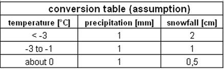
Figure 4.2.1: Conversion table: mm precipitation in cm snowfall (estimation)
An also important problem is the measurement of snow amount and snow depth. Because of temperature variability the snow becomes drier or more moist, which can influence the snow depth. Due to snow shipping with heavy wind the measured snow amount values can be false.
There are few problems of precipitation forecast, but if the strengths and the weaknesses of the used models are considered and more experience is accumulated by the forecaster, the forcasts become better and better. Also important is to monitor the weather development to be aware of changes thus to modify the forecast.