Typical colours
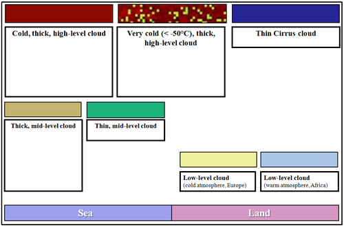
Fig. 3 shows the typical colours of the Night Microphysics RGB images.
- The colours of the clouds depend on the cloud top temperature, cloud top phase and cloud thickness (transparency).
- The colours of the cloud free surface depend on the surface temperature and the moisture content of the atmosphere
| Figure 3: : Typical colours of the Night Microphysics RGB (Source: Jochen Kerkmann, MSG Interpretation Guide, EUMETSAT) |
|
The typical colours of the clouds are as follows:
- Low-level water clouds in mid-latitude are light greenish or yellowish. Thicker water clouds appear in stronger green tones. Warmer water clouds top are depicted in more blue tones. (Warm water clouds over Africa are greyish blue.)
- Thick mid-level clouds appear slightly brownish.
- Thin mid-level clouds appear green.
- Thin semitransparent ice clouds are dark blue, or bluish. The actual tone depends on several factors, like the transmissivity of the cloud and the colour of the underlying surface.
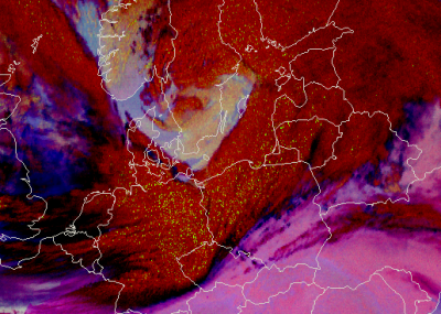
- Thick ice clouds are brownish red. However, if the top of a thick ice cloud is very cold - below -50 °C - greenish dots appear on their tops (Fig. 4). These 'noisy pixels' have similar colours to thick water clouds, but it is important to remember that cold, thick cloud top with green dots means it is very cold, not that there are warm water clouds in some pixels! What, then, causes the 'green dots' feature? For very cold thick clouds the measured radiation is almost zero in the IR3.9 channel, and the retrieved IR3.9 brightness temperature is noisy.
| Figure 4: Night Microphysics RGB for 15 March 2014 at 02:25 UTC. The green dots on the brownish red cloud top indicate very cold cloud top. |
|
The typical colours of the cloud-free surface depend on the surface temperature and the moisture content of the atmosphere, especially on low-level moisture content.
The colour difference is usually due to the different temperature. At night the sea is usually warmer than the land, so
- the sea usually appears bluish, while
- the (non-deserted) land usually appears pinkish.
However, the colour of the cloud-free surface depends not only on the surface temperature, but on the atmospheric low-level moisture content as well:
- moist areas appear more bluish, while
- dry areas appear more pinkish.
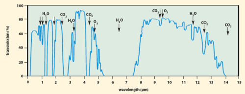
In cloud free regions both the (IR12-IR10.8) and the (IR10.8-IR3.9) differences depend on atmospheric moisture content. A cloud-free atmosphere is more transparent around 3.9 µm than around 10.8 µm, and it is more transparent around 10.8 µm than around 12.0 µm, see Fig. 5. If the moisture content is higher, the red and the green components of the surface will be lower, so the mixed colour will appear more bluish.
| Figure 5: Atmospheric transmission spectra (Source: http://www.photonics.com/EDU/Handbook.aspx?AID=25132) |
|
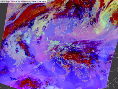
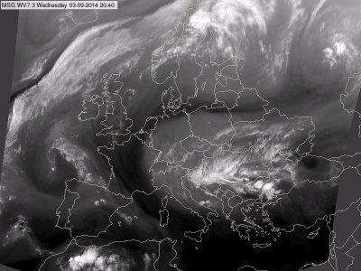
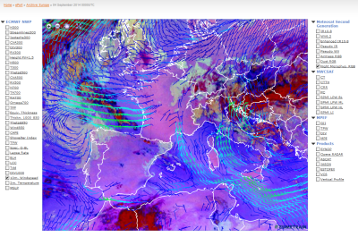
Fig 6a shows an example when the effect of the moisture content is clearly seen in the Night Microphysics RGB image. The structure of bluish and pinkish tones over the Mediterranean and north of Germany and Poland reflect the effects of the atmospheric moisture. For comparison, see the WV7.3 image in Fig. 6b, which shows the mid-layer moisture content of cloud-free areas. Fig. 6c shows the Night Microphysics RGB image from three hours later overlaid with ECMWF 10 m wind analyses. The northerly flow pushes much drier air from France over the Mediterranean, causing the observed moisture pattern over the sea.
| Figure 6a: Night Microphysics RGB for 3 September 2014 at 20:40 UTC |
|
| Figure 6b: WV7.3 image for 3 September 2014 at 20:40 UTC |
|
| Figure 6c: Night Microphysics RGB overlaid by ECMWF 10 m wind vectors analysis for 4 September 2014 at 00:00 UTC (Source: EUMeTrain, e-port) |
|