Table of Contents
Introduction and Conceptual Models
Thanks are due to Mr. Riosalido from Instituto Nacional de Meteorologica (I.N.M.) in Madrid in selecting the case and adding important information and advice.
This case study handles the life cycle of an Upper Level Low in chronological order. The system developed over the Atlantic Ocean west of the
Iberian Peninsula and reached its mature stage near the entrance of the Strait of Gibraltar on the 28th of September.
From the 26th till the 30th of September 1997 this system was responsible for heavy rainfall especially in the southern part of Spain and the
northern part of Marocco. At the east side of the ULL frontogenesis in an unstable environment caused upward motion and the development of
cloud bands with embedded Cb's, Cb Clusters and MCSs. The severe weather conditions were at their maximum in the dissolution stage of the Upper
Level Low. In the southern and south eastern parts of the peninsula flooding affected many areas and caused a lot of damage to agriculture. In
Spain there were five casualties due to the flooding and two as a result of a plane crash in severe weather conditions.
Overview of satellite features and conceptual models
|
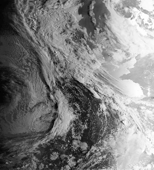
24 September 1997/08.00 UTC - NOAA CH2 image
|
24 September 1997/08.00 UTC - NOAA CH5 image
|
|
|
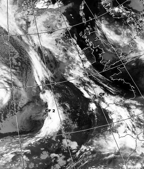
The initial situation on 24 September 1997 08.00 UTC. Cloud systems indicating the development of the Upper Level Low, can be seen in South Western Europe:
- A Cold Front ("CF I") extending from NE Spain to W. Ireland in an irregular cloud band (compare Conceptual Models: Cold Front ).
- The cloud system over the eastern part of the Atlantic can also be identified as a Cold Front ("CF II") (compare Conceptual Models: Cold Front ) and is starting to tear-off an extended baroclinic zone stretching out north towards Greenland.
CF II is approaching the Iberian Peninsula while CF I is in a decaying stage.
To the rear of CF I a trough at upper levels has formed. To the rear of CF II a (small) trough is also developing.
The Trough Stage
|
24 September 1997/12.00 UTC - Meteosat IR image; green: equivalent thickness 500/850 hPa, red: height contours 500 hPa
|
|
|
|
- CF I is located over the Iberian Peninsula, and is situated ahead of the upper level trough.
- CF II is rapidly moving eastwards and is extending over the Atlantic Ocean at 20W and lies upstream of the 500 hPa trough axis of the main system. (compare Conceptual Models: Upper Level Low - Meteorological physical background ).
The Tear-off Stage
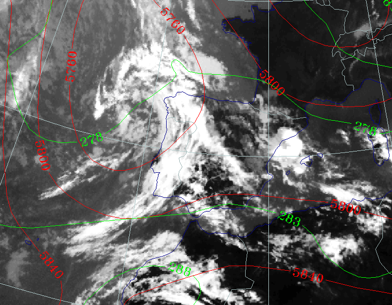
|
25 September 1997/23.00 UTC - Meteosat IR image; green: equivalent thickness 500/850 hPa, red: height contours 500 hPa
|
|
|
- CF I is partly dissolved and has merged with CF II.
- The remainders of the CF (II) is extending from N. Marocco to N. Portugal.
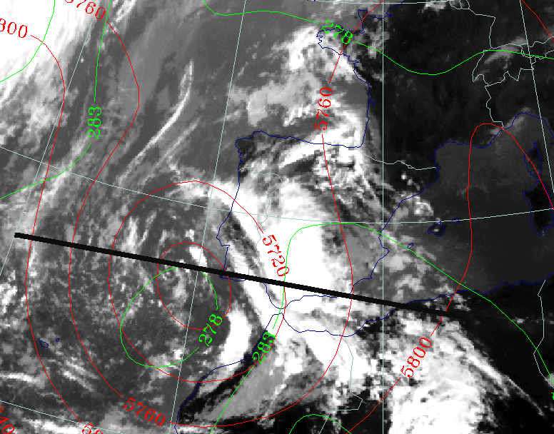
- The height contours are showing a closed circulation with minima of 576 gpdam. The fronts have lost their association with the cloud bands that extended in northern direction towards Greenland and Ireland. This indicates the tear-off stage of an Upper Level Low (Compare Conceptual Models: Upper Level Low - Meteorological physical background ).
- There is cold advection over the Atlantic Ocean (the western part of Portugal). This can be seen in the isohypses at 500 hPa, which are perpendicular to the lines of equivalent thickness. This indicates that the ULL is still moving and developing.
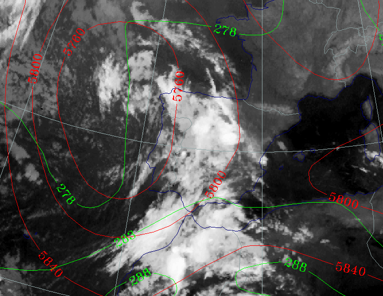
The Cut-off Stage
|
27 September 1997/00.00 UTC - Meteosat IR image; green: equivalent thickness 500/850 hPa, red: height contours 500 hPa
|
|
|
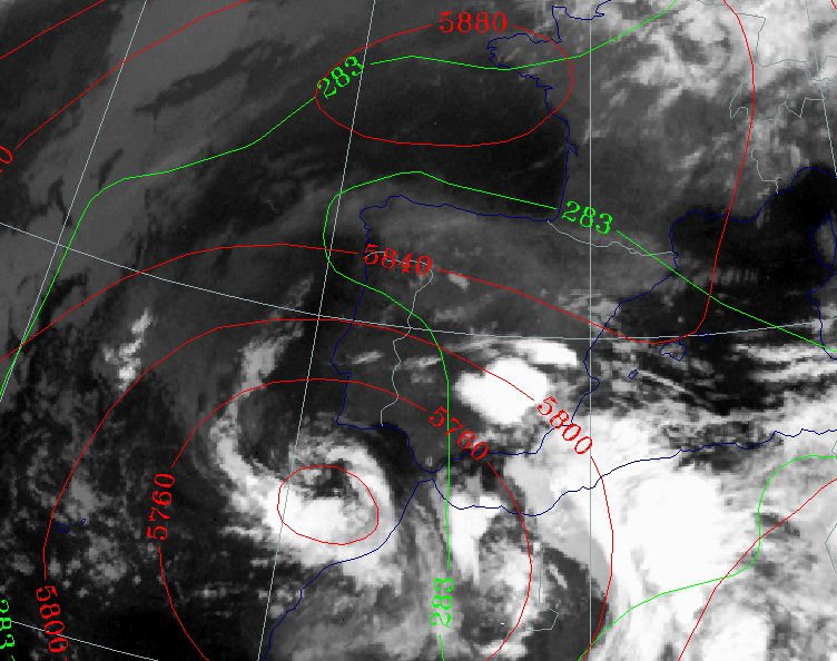
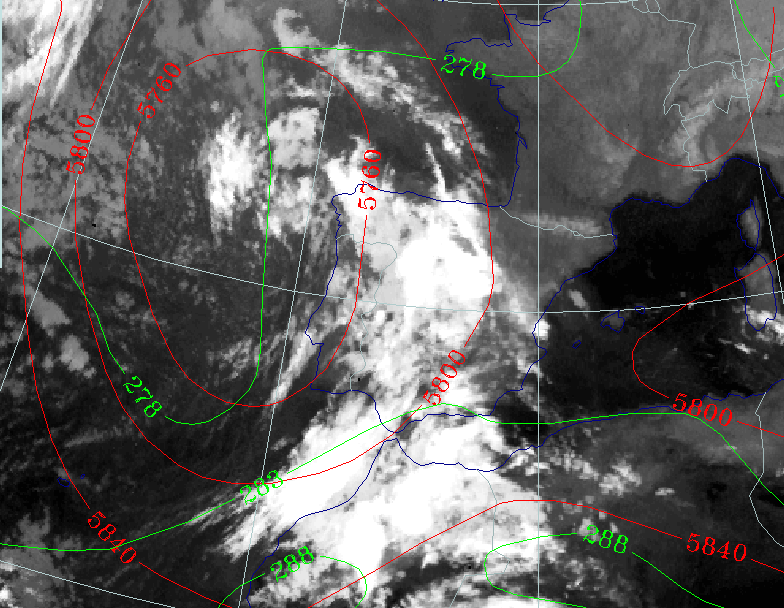
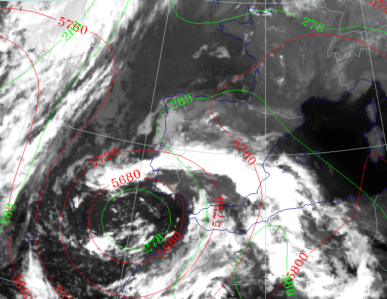
- The centre of the ULL has moved in a southward direction, with minimum height contour values of 568 gpdam, indicating a further deepening of the ULL.
- The ULL is in its cut-off stage because cloud and height tear-off has stopped and the ULL is now more pronounced.
- Cold advection can be found below the centre of the ULL, near the west coast of Morocco.
- The remnants of the CF band starts to curve cyclonically around the centre of the ULL.
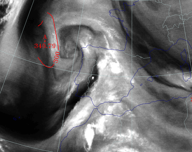
- An intense white spot can be seen at the west side of a thickness ridge above Morocco, indicating an MCS.
|
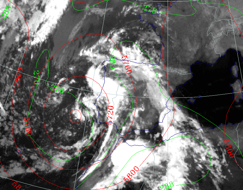
28 September 1997/00.00 UTC - Meteosat IR image; green: equivalent thickness 500/850 hPa, red: height contours 500 hPa
|
|
|
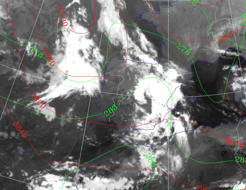
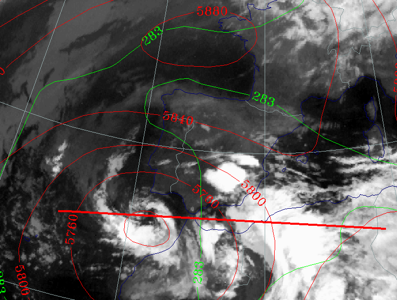
- The centre of ULL is now at its lowest value and is located SW of Portugal.
- The height contours at 500 hPa show a well-developed closed circulation (compare Conceptual Models: Upper Level Low - Meteorological physical background ).
- Values of Cold Advection are near zero, because the centre of the thermal low has the same location as the minimum in the height contours.
- The cyclonic curvature of the cloud bands becomes stronger, which indicates the maturity of the cut-off stage of the ULL.
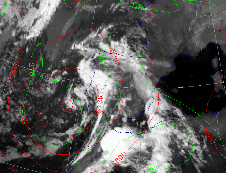
The Dissolution Stage
|
29 September 1997/00.00 UTC - Meteosat IR image; green: equivalent thickness 500/850 hPa, red: height contours 500 hPa
|
|
|
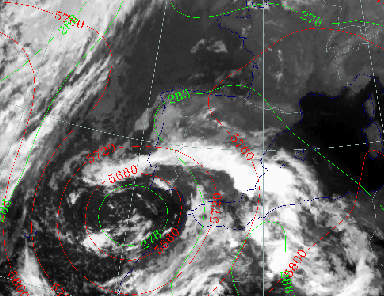
- The ULL has propagated in a SE direction. The values of the isohypses in the centre show that the ULL is in its early dissolution stage.
- CB clusters develop over S Spain and N Morocco at the edge of the ULL, indicating a potentially unstable stratification of the troposphere. (Compare Conceptual Models: Cumulonimbus (Cb) and Mesoscale Convective System (MCS) and Conceptual Models: Cumulonimbus Cluster ).
- At this stage the most severe weather was observed. In particular, high amounts of rainfall were observed over Andalucia and the
Alicante province.
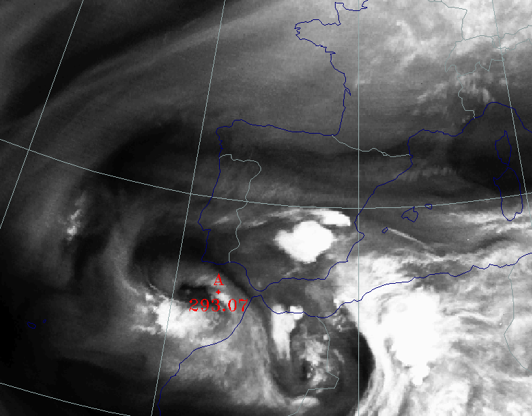
In Alicante the maximum of the intensity of the rainfall was 60mm/hr. In a period of 5 hours 267 mm was measured.
|
30 September 1997/00.00 UTC - Meteosat IR image; green: equivalent thickness 500/850 hPa, red: height contours 500 hPa
|
|
|
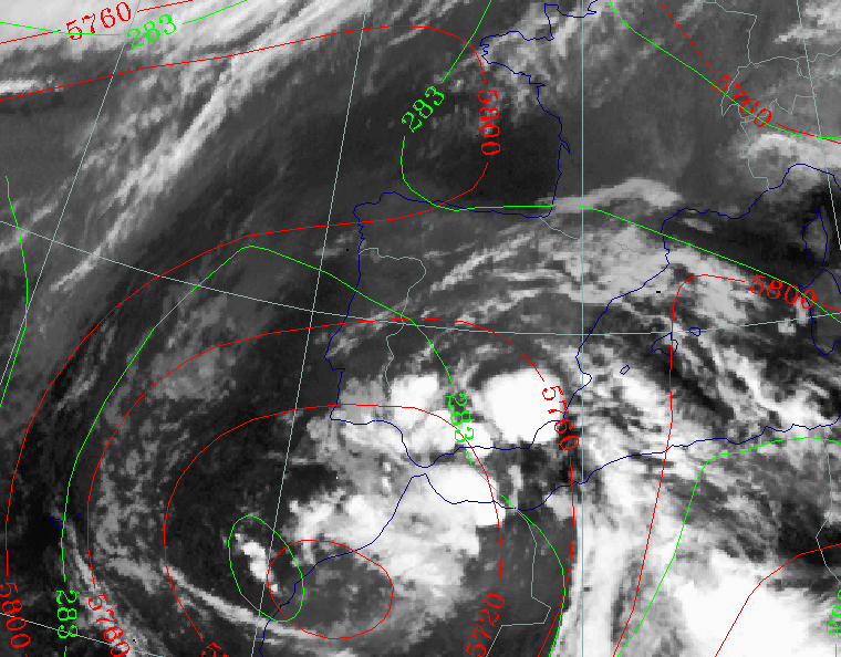
- The ULL is dissolving further, which can be seen in the height contours at 500 hPa, which are showing higher values in the centre of the ULL.
- Warmer, moist air has spiralled into the centre of the low as can be seen in the cloud imagery.
- Embedded CB Clusters can be seen in the area of the thickness ridge above SE Spain and west Algeria, indicating an unstable airmass.
The Upper Level Trough Stage
Synoptic situation
|
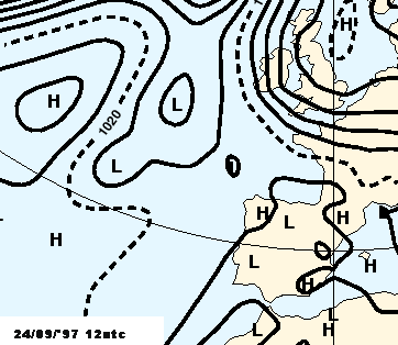
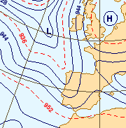
24 September 1997/12.00 UTC - Meteosat VIS image; blue: height contours 1000 hPa
|
24 September 1997/12.00 UTC - Surface chart
|
|
|
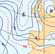
A frontal cloud band extends from southern Spain across the Bay of Biscay towards Ireland. The front is quasi stationary in the deformation
area of a "saddle point" between a low over Northwest Africa, another low to the South west of Ireland, a high over the North Sea
and another high north of the Azores.
Between 40N and 50N, at a longitude of about 20W, a frontal zone is moving eastwards in the direction of the Iberian peninsula.
24 September 1997/12.00 UTC
Analysis of the system
|
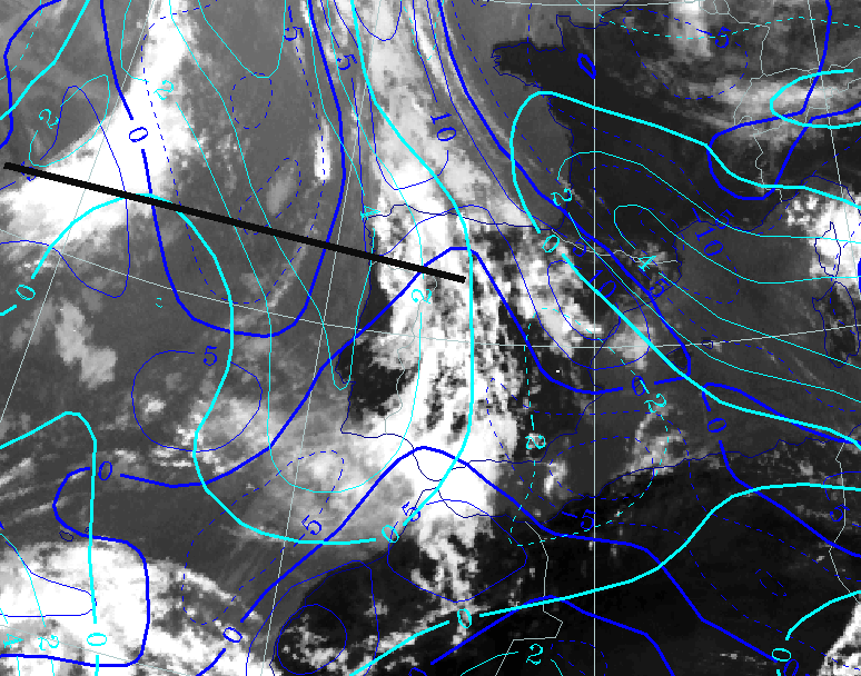
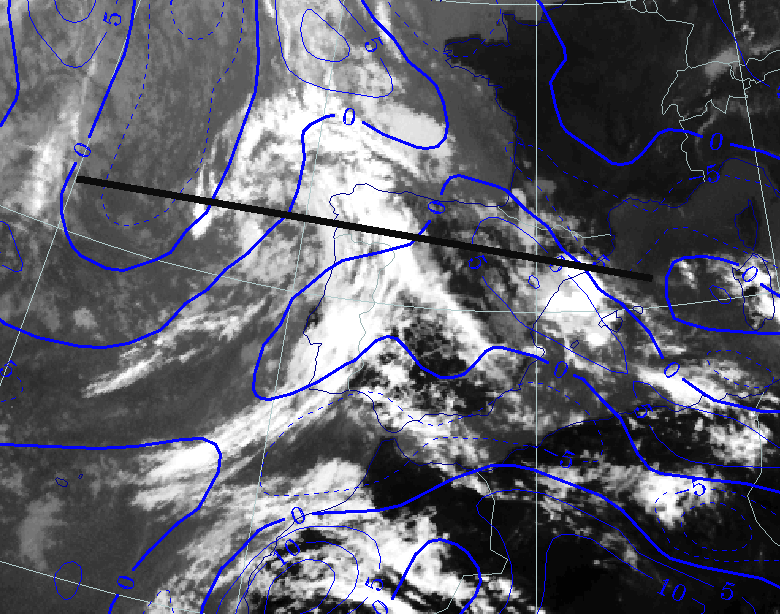
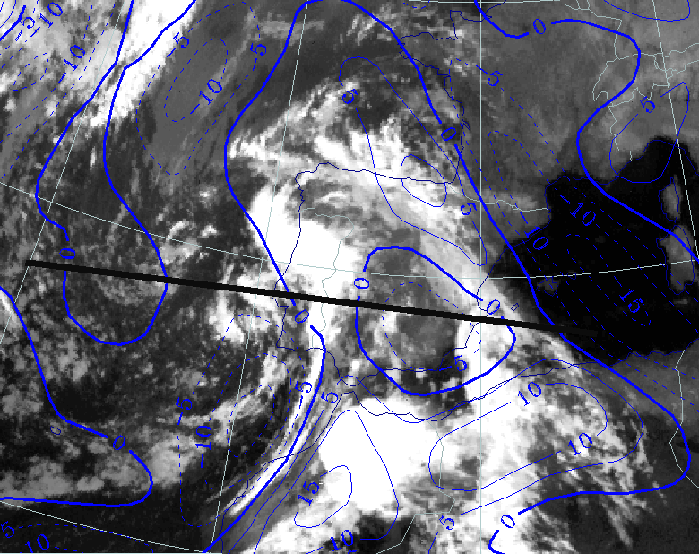
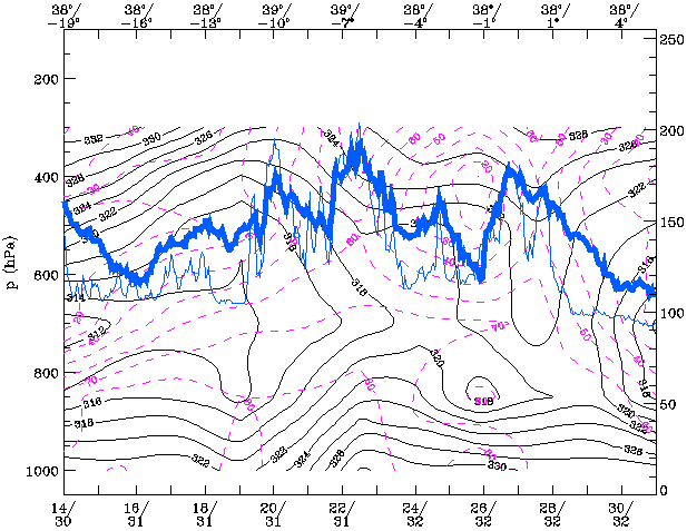
24 September 1997/12.00 UTC - Meteosat IR image; blue: thermal front parameter (TFP) 500/850 hPa, cyan: vorticity 500 hPa; position of
vertical cross section indicated
|
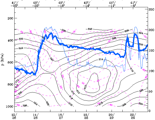
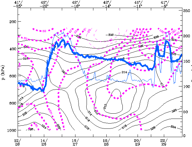
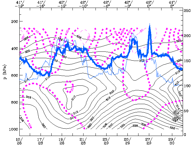
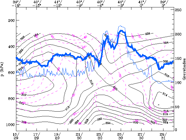
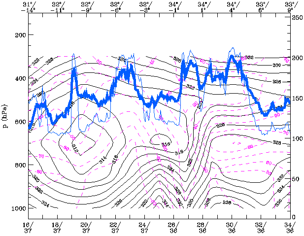
24 September 1997/12.00 UTC - Vertical cross section; black: isentropes (ThetaE), magenta: relative humidity, blue thin: IR pixel
values, blue thick: WV pixel values
|
|
|
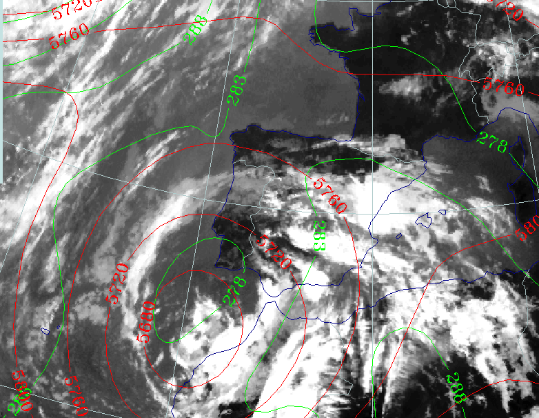
The front over Spain towards Ireland is well defined in the thermal front parameter but the already decoupled front which approaches from the Atlantic is poorly represented by this model parameter. Also the cloud configuration off the coast of Morocco is not well reflected.
|
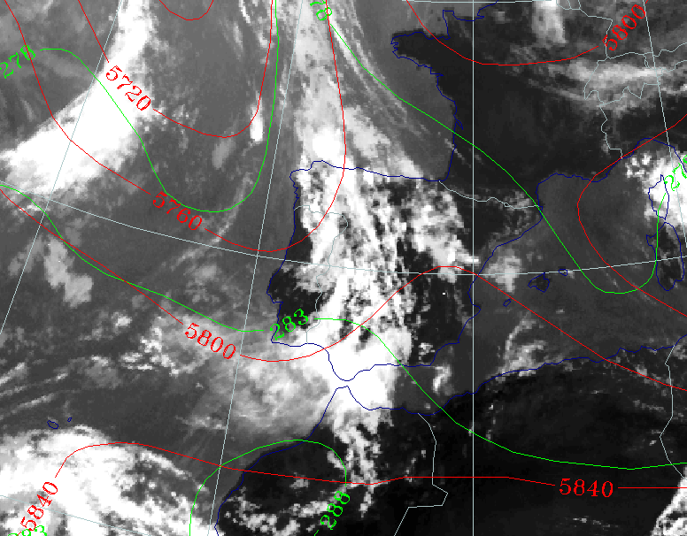
24 September 1997/12.00 UTC - Meteosat IR image; green: equivalent thickness 500/850 hPa, red: height contours 500 hPa
|
24 September 1997/12.00 UTC - Vertical cross section; black: isentropes (ThetaE), magenta: relative vorticity, blue thin: IR pixel
values, blue thick: WV pixel values
|
|
|
The front over Spain lies in the axis of a thickness ridge and, in the cross section, has the characteristics of an occlusion in the ThetaE pattern. This is also the case with the rapidly moving front over the Atlantic. To the rear of the first front, there is a trough visible in the height contours at 500 hPa and in the thickness pattern.
The vorticity maxima in the troughs behind both fronts are very distinct, both at the 500hPa level and in the cross section. In the cross section the highest values of vorticity appear at a higher level than 500 hPa. The 300hPa level is more representative of the situation (see chart below).
|
24 September 1997/12.00 UTC - 300 hPa contours
|
|
|
The trough at 300 hPa over the west part of the Iberian Peninsula is much sharper than at lower levels.
The smaller trough at 20W is of particular interest. This trough is moving rapidly eastward into the main trough and reactivates this trough
for the further development of the trough into an Upper Level Low ("trigger" mechanism).
25 September 1997/00.00 UTC
Analysis of the system
|
25 September 1997/00.00 UTC - Meteosat IR image; blue: thermal front parameter (TFP) 500/850 hPa; position of vertical cross section
indicated
|
25 September 1997/00.00 UTC - Vertical cross section; black: isentropes (ThetaE), magenta: relative humidity, blue thin: IR pixel
values, blue thick: WV pixel values
|
|
|
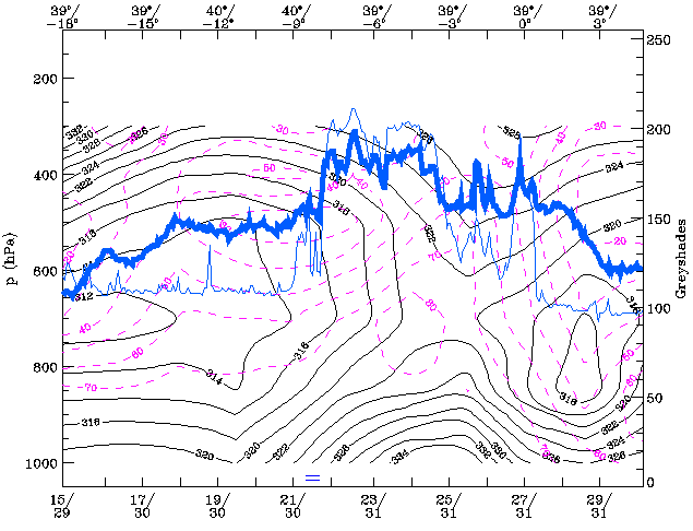
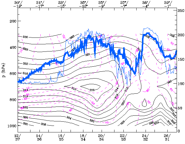
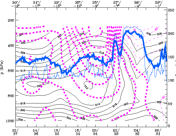
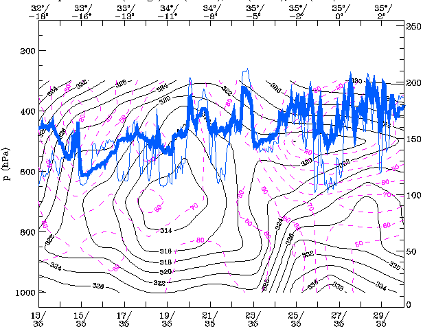
The front over Spain has moved slightly eastward and is also well defined in the model parameters. It is visible in the TFP values in the image as well as in the humidity parameter in the cross section. The performance of the model fields in detecting the rapidly eastward moving front west of Portugal is poor. Negative TFP and low humidity values don't fit with the cloud configuration in the IR image. Most striking is the strong instability in the front over Spain with a strong lapse rate up to 700 hPa, as seen in the ThetaE values in the cross section.
|
25 September 1997/00.00 UTC - Meteosat IR image; green: equivalent thickness 500/850 hPa, red: height contours 500 hPa
|
25 September 1997/00.00 UTC - Vertical cross section; black: isentropes (ThetaE), magenta: relative vorticity, blue thin: IR pixel
values, blue thick: WV pixel values
|
|
|
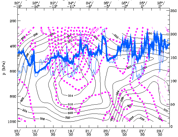
The Upper Level trough now covers a broad zone containing both systems while in the relative topography the system over Spain is in a thickness ridge and the one west of Portugal is in a trough. In the cross section two maxima of relative vorticity can be distiguished both to the rear of the two systems.
|
25 September 1997/00.00 UTC - 300 hPa contours
|
|
|
The two vorticity maxima which are visible in the cross section are very distinct at 300hPa as two pronounced troughs.
25 September 1997/12.00 UTC
Analysis of the system
|
25 September 1997/12.00 UTC - Meteosat IR image; blue: thermal front parameter (TFP) 500/850 hPa; position of vertical cross section
indicated
|
25 September 1997/12.00 UTC - Vertical cross section; black: isentropes (ThetaE), magenta: relative humidity, blue thin: IR pixel
values, blue thick: WV pixel values
|
|
|
The most easterly front has deformed and dissolved more and more but is still visible in the TFP over north eastern Spain and the Bay of
Biscay. A cluster of CBs is visible in the Barcelona area. The more westerly front is now over Portugal with still no clear indications in the
model fields. In the cross section, the humidity field of the latter system doesn't fit with the actual pixel values of IR and WV; the maximum
of the relative humidity from the model is situated left (west) of the maximum pixel values. The deep unstable layer which was visible in the
ThetaE at 00.00 UTC is still present at the same position now to the rear of the easterly front.
In the area of the cloud band over Morocco the model also indicates a well developed TFP.
|
25 September 1997/12.00 UTC - Meteosat IR image; green: equivalent thickness 500/850 hPa, red: height contours 500 hPa
|
25 September 1997/12.00 UTC - Vertical cross section; black: isentropes (ThetaE), magenta: relative vorticity, blue thin: IR pixel
values, blue thick: WV pixel values
|
|
|
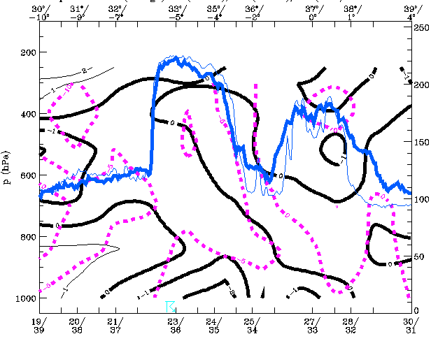
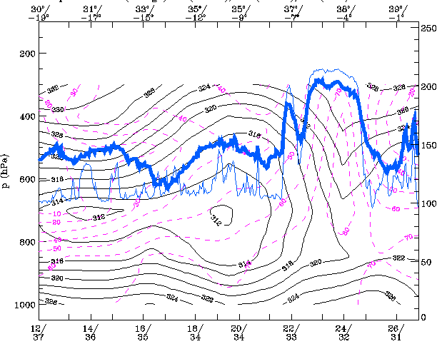
Both fronts are now in a broad thickness ridge. The 500hPa trough has deepened and sharpened. The trough axis lies at the rear of the thickness ridge and ahead of a distinct thickness trough which means warm advection over the Iberian peninsula and cold advection more to the west. A very strong maximum of relative vorticity is present in the axis of the 500hPa trough, which can be seen in the cross section.
|
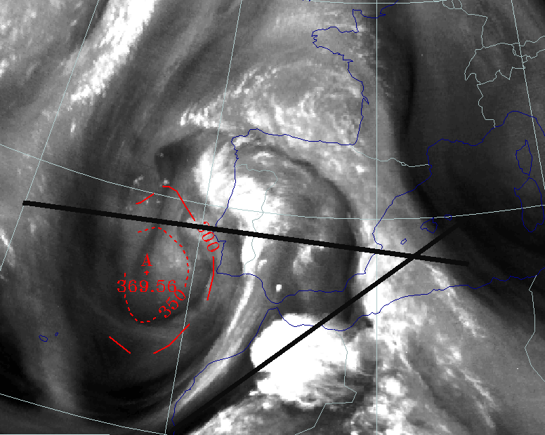
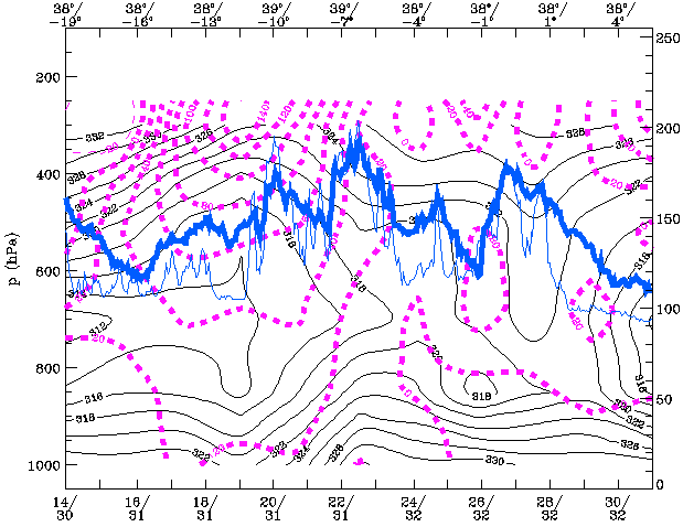
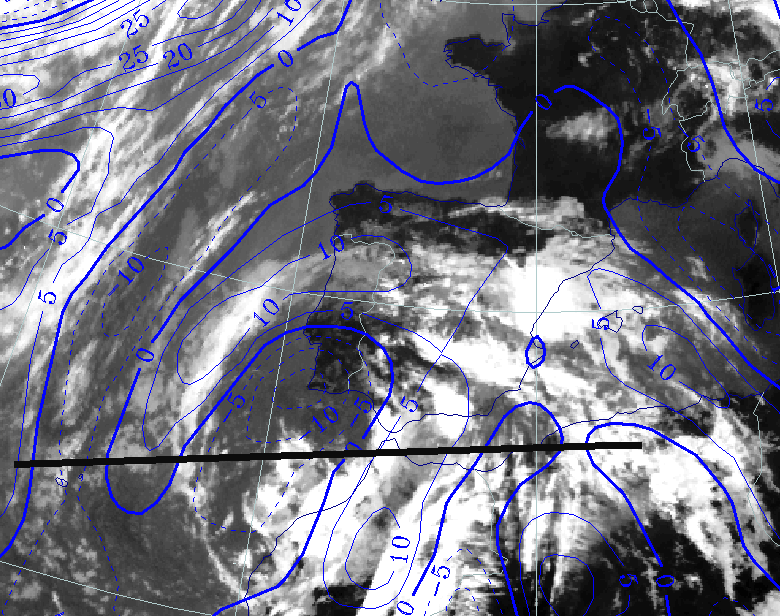
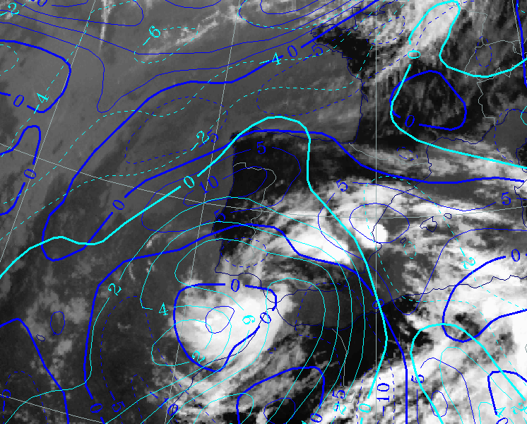
25 September 1997/12.00 UTC - Meteosat WV image; red: height of PV=1 unit
|
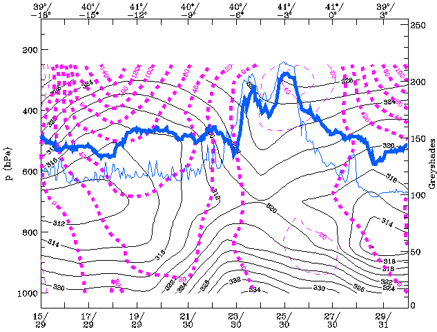
25 September 1997/12.00 UTC - Vertical cross section; black thin: divergence, black thick: convergence, magenta thick: vertical motion
(omega) - upward motion, magenta thin: vertical motion (omega) - downward motion, blue thin: IR pixel values, blue thick: WV pixel
values
|
|
|
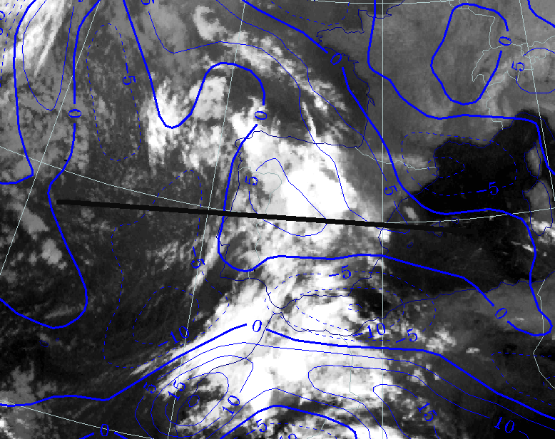
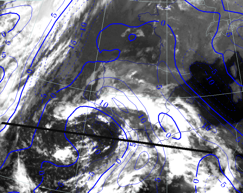
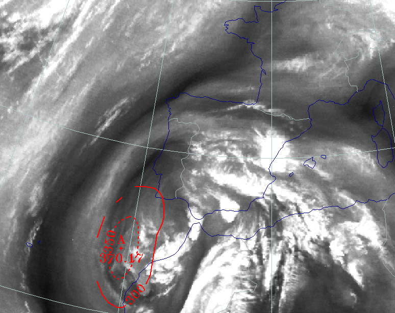
In the WV image the second front over the Iberian Peninsula is very distinct. But in the cross section no significant vertical velocity is evident while in the (old) front that is located more to the east, relatively strong vertical motion (omega) is visible. West of Portugal a WV dark stripe can be seen indicating dry sinking air. There is a minimum of the height of the tropopause more to the north in the Upper Level Trough but the values are not particularly low.
The Tear-off Stage
|
24 September 1997/23.00 UTC - Meteosat VIS image; green: equivalent thickness 500/850 hPa, red: height contours 500 hPa
|
25 September 1997/00.00 UTC - Surface chart; accumulated precipitation 12.00 - 00.00 UTC
|
|
|
An extended area of high pressure is stretching out from the Azores towards the North Sea. The Iberian Peninsula is under the influence of a
low pressure area. The height of 500hPa is showing a closed circulation around a minimum of 576 gpdam, indicating an Upper Level Low in it's
tear-off stage which is characterised by the development of an inverted omega shape (Compare
Conceptual Models: Upper Level Low - Meteorological physical background
). The thickness trough is still west of the 500 hPa minimum which is a signal for further development of the Upper Level Low.
The cloud band over Spain no longer has any connection with the original front over the Bay of Biscay and Ireland.
26 September 1997/00.00 UTC
Analysis of the system
|
26 September 1997/00.00 UTC - Meteosat IR image; blue: thermal front parameter (TFP) 500/850 hPa; position of vertical cross section
indicated
|
26 September 1997/00.00 UTC - Vertical cross section; black: isentropes (ThetaE), magenta: relative humidity, blue thin: IR pixel
values, blue thick: WV pixel values
|
|
|
A maximum of the TFP accompanies the frontal cloud band, which is extending from N. Morocco to NW Spain.
This is a combination of the front which came from the west at 25/9 and the baroclinic zone over Morocco that day. The TFP from the model now
fits quite well with the cloud pattern. The more eastern front over NE Spain on the 25 September has dissolved almost completely.
In the cross section the front has the characteristics of an occlusion. The ThetaE pattern also shows a strong unstable layer below 700 hPa in
that area.
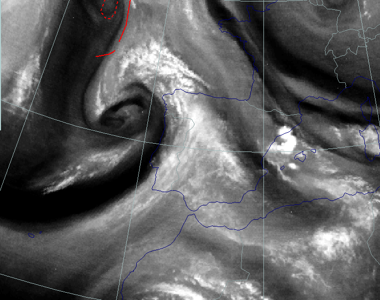
|
26 September 1997/00.00 UTC - Meteosat IR image; red: height of PV=2 units
|
26 September 1997/00.00 UTC - Vertical cross section; black: isentropes (ThetaE), magenta: relative vorticity, blue thin: IR pixel
values, blue thick: WV pixel values
|
|
|
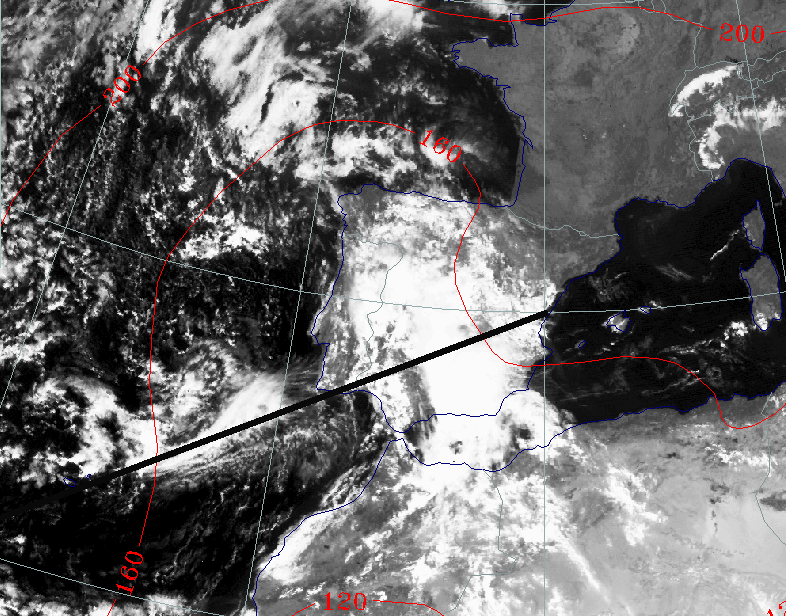
The spiral in the WV image off the NE coast of Portugal, indicates the centre of the ULL. In the cross section a maximum in vorticity is calculated at that position. The maximum of the geopotential height of the PV=2 units is more to the west indicating dry descending air.
26 September 1997/12.00 UTC
Analysis of the system
|
26 September 1997/12.00 UTC - Meteosat IR image; blue: thermal front parameter (TFP) 500/850 hPa; position of vertical cross section
indicated
|
26 September 1997/12.00 UTC - Vertical cross section; black: isentropes (ThetaE), blue: relative humidity, blue thin: IR pixel
values, blue thick: WV pixel values
|
|
|
The TFP from the model doesn't fit well with the image, when compared with the humidity parameter and the various grey shades of the IR; the maximum of relative humidity is calculated to be more to the east.
|
26 September 1997/12.00 UTC - Meteosat IR image; red: height 1000 hPa; position of vertical cross section indicated
|
26 September 1997/12.00 UTC - Vertical cross section; black: isentropes (ThetaE), magenta: relative humidity, blue thin: IR pixel
values, blue thick: WV pixel values
|
|
|
South of the centre of the ULL, a cloud shield has rapidly developed. This shield is very distinct in IR and WV, but less clear in VIS. The
relative humidity parameter in the cross section shows a maximum at about 300hPa, fitting quite well with the images. At lower levels much less
humidity is present indicating an upper air feature.
This cloud shield is the result of upper level convergence which is often observed at the western and southern part of an ULL in its tear-off
stage.
|
26 September 1997/12.00 UTC - Meteosat IR image; red: height of PV=2 units; position of vertical cross section indicated
|
26 September 1997/12.00 UTC - Vertical cross section; black: isentropes (ThetaE), magenta thick: vorticity advection - PVA, magenta
thin: vorticity advection - NVA, blue thin: IR pixel values, blue thick: WV pixel values
|
|
|
The idea of an upper air feature is strengthened by the PVA parameter in the Cross section; a PVA maximum is found only very high in the
troposphere while at 500hPa the PVA is about zero.
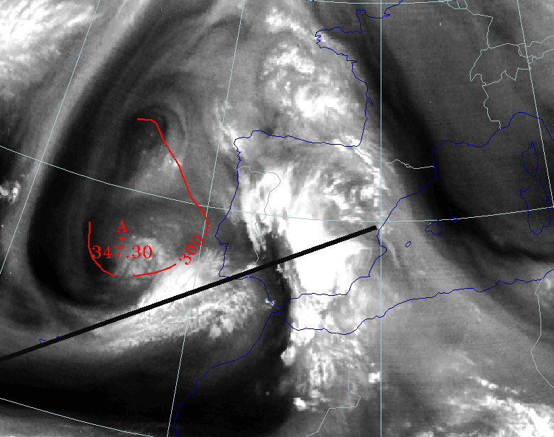
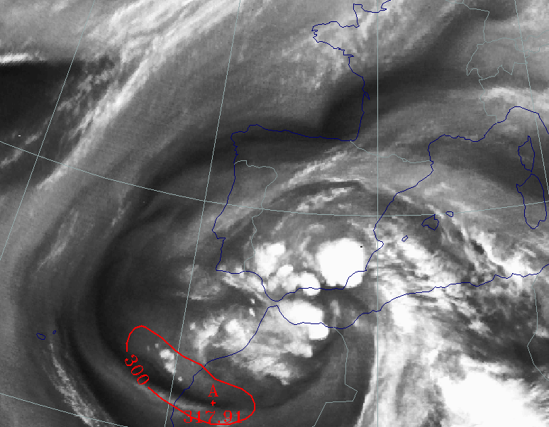
In the WV image two vortexes can be detected. Both are in an area of low tropopauses as can be seen by the relative low height of the PV = 2 in
that area, with a minimum of 347 hPa near the centre of the southern vortex. The two rotation centres form a "mushroom" configuration
which is known in literature as the start of a cut-off process in the development of an ULL.
|
26 September 1997/12.00 UTC - Meteosat IR image; green: equivalent thickness 500/850 hPa, red: height contours 500 hPa
|
26 September 1997/12.00 UTC - Vertical cross section; black: isentropes (ThetaE), magenta: relative vorticity, blue thin: IR pixel
values, blue thick: WV pixel values
|

|
|
The tear-off stage becomes more pronounced, as can be seen in the contours, which are showing values of less than 572 gpdam in the centre of
the ULL, indicating stronger cyclonic rotation.
Cold advection prevails over the Atlantic Ocean (West of Portugal), whilst warm advection is still going on above the whole Iberian Peninsula.
This can be seen in the contours at 500 hPa, which are perpendicular to the lines of equivalent thickness, meaning the ULL is still moving and
developing.
The cross section shows strong vorticity in the centre of the ULL especially at higher levels (300hPa).
The Cut-off Stage
Synoptic situation
|
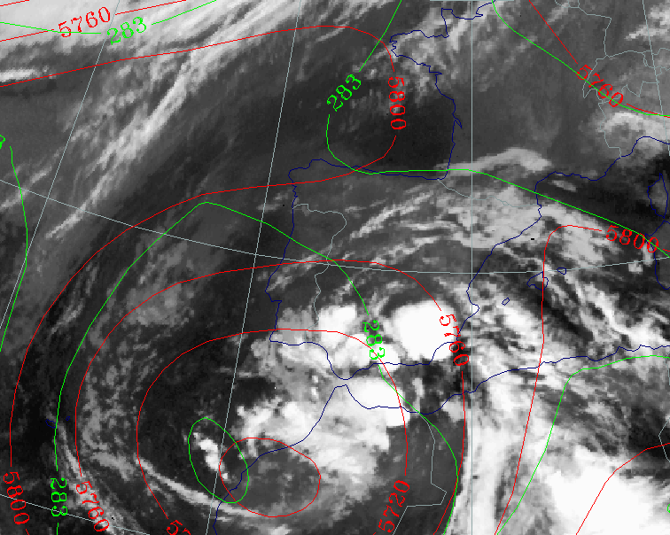
26 September 1997/23.00 UTC - Meteosat IR image; green: equivalent thickness 500/850 hPa, red: height contours 500 hPa
|
27 September 1997/00.00 UTC - Surface chart; accumulated precipitation 12.00 - 00.00 UTC
|
|
|
The depression over Morocco becomes a dominant feature in the surface chart in the area of the Upper Level Low. The centre of the ULL now lies off the coast of southeast Portugal. The numerical model also calculates precipitation, which coincides quite well with the structures seen in the satellite image. The temperature advection patterns are now not so pronounced, but there is still some cold advection to the west of, and some warm advection to the east of the ULL centre. The cloud configuration of the upper air feature (see part 3) has now moved towards Portugal. Over northern Morocco a extended CB cluster has formed which has some characteristics of an MCS, but the calculated amounts of precipitation in that area are not significant.
27 September 1997/00.00 UTC
Analysis of the system
|
26 September 1997/23.00 UTC - Meteosat IR image; blue: thermal front parameter (TFP) 500/850 hPa; position of vertical cross section
indicated
|
27 September 1997/00.00 UTC - Vertical cross section; black: isentropes (ThetaE), magenta: relative humidity, blue thin: IR pixel
values, blue thick: WV pixel values
|
|
|
Two bands in the structure of TFP can be discriminated; one over Algeria and the eastern and northern part of Spain, and one over north Morocco
and Portugal. In the ThetaE pattern of the cross section the fronts are difficult to detect, but the humidity field is quite realistic when
comparing it with the pixel values of the satellite image.
The unstable layer over the main land of the peninsula is still present.
|
26 September 1997/23.00 UTC - Meteosat IR image; red: height of PV=2 units; position of vertical cross sections indicated
|
27 September 1997/00.00 UTC - Vertical cross section; black: isentropes (ThetaE), magenta: relative vorticity, blue thin: IR pixel
values, blue thick: WV pixel values
|
|
|
In the WV image the two cloud bands over the peninsula are very distinct, as is the CB cluster over northern Morocco. Dry air has spiralled
into the centre of the ULL and the height of the tropopause (height of the PV = 2 units) has lowered further in the last 12 hours with the
minimum in the centre of the ULL.
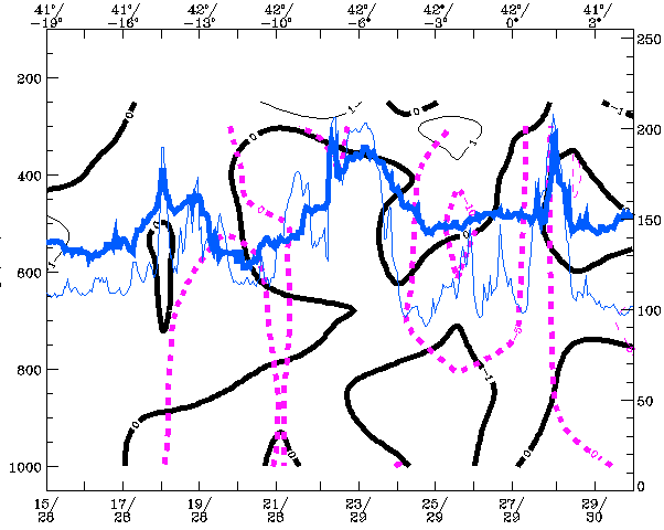
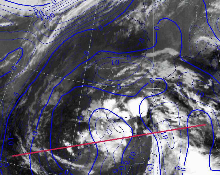
Vorticity in the centre has become stronger as it can be seen in the cross section along the 38° latitude.
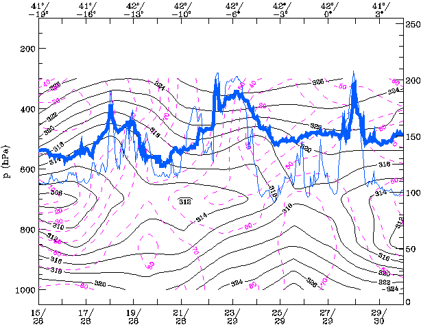
|
24 September 1997/12.00 UTC - Vertical cross section; black thin: divergence, black thick: convergence, magenta thick: vertical motion
(omega) - upward motion, magenta thin: vertical motion (omega) - downward motion, blue thin: IR pixel values, blue thick: WV pixel
values
|
|
|
In the area of the CB Cluster over Morocco strong negative values of divergence (i.e. convergence) are calculated at levels near the surface and, as a result, there is strong upward motion in the levels above.
27 September 1997/12.00 UTC
Analysis of the system
|
27 September 1997/12.00 UTC - Meteosat IR image; blue: thermal front parameter (TFP) 500/850 hPa, cyan: vorticity 500 hPa; position of
vertical cross section indicated
|
27 September 1997/12.00 UTC - Vertical cross section; black: isentropes (ThetaE), magenta: relative vorticity, blue thin: IR pixel
values, blue thick: WV pixel values
|
|
|
The two cloud bands with separate TFP maxima are still to be seen, but the front to the east is now dissipating. The MCS has moved to the southern part of Spain. The vorticity maximum of the ULL has shifted somewhat to the south. It is also very pronounced in the 500 hPa vorticity field and in the cross section.
|
27 September 1997/12.00 UTC - Meteosat IR image; red: height of PV=2 units
|
27 September 1997/12.00 UTC - Vertical cross section; black: isentropes (ThetaE), magenta: relative humidity, blue thin: IR pixel
values, blue thick: WV pixel values
|

|
|
The tropopause minimum is now situated south east of the spiral of moist air which indicates the centre of the ULL. The sharp edge seen in the
WV image to the rear of the MCS over south west Spain and Portugal is striking, indicating descending and drying air. In the cross section, low
relative humidity values are visible south west of the ULL centre. This is an indication of southward moving cold and dry air.
The instability of the airmas can still be observed in the lower levels in the ThetaE pattern.
|
27 September 1997/12.00 UTC - Meteosat IR image; green: equivalent thickness 500/850 hPa, red: height contours 500 hPa; position of
vertical cross section indicated
|
27 September 1997/12.00 UTC - Vertical cross section; black: isentropes (ThetaE), magenta: relative vorticity, blue thin: IR pixel
values, blue thick: WV pixel values
|
|
|
The low centre in the relative topography is ( just as the max of PV = 2 units) situated south of the ULL centre indicating the southward movement of the ULL. In the cross section the strong vorticity maximum is well presented. More to the east, above the MCS, strong negative values of vorticity are shown indicating anticyclonic outflow of the ascending air from lower levels.
28 September 1997/00.00 UTC
Analysis of the system
|
27 September 1997/23.00 UTC - Meteosat IR image; blue: thermal front parameter (TFP) 500/850 hPa; position of vertical cross section
indicated
|
28 September 1997/00.00 UTC - Vertical cross section; black: isentropes (ThetaE), magenta: relative humidity, blue thin: IR pixel
values, blue thick: WV pixel values
|
|
|
The cloud configuration forms a spiral structure but the TFP doesn't fit well with the image. The strong TFP over north-east Morocco and
southern Spain is also reflected in the cross section with a very strong horizontal gradient in the ThetaE near the surface over north Algeria.
Here there are characteristics of a Cold Front.
Ahead of this gradient zone the air is highly unstable up to 600 hPa.
|
27 September 1997/23.00 UTC - Meteosat IR image; green: equivalent thickness 500/850 hPa, red: height contours 500 hPa
|
28 September 1997/00.00 UTC - Vertical cross section; black: isentropes (ThetaE), magenta: relative vorticity, blue thin: IR pixel
values, blue thick: WV pixel values
|
|
|
The coldest air has now moved around the ULL and the minimum of thickness values is located exactly in the centre of the low. Cold advection near the western part has stopped, but warm advection over Spain is continuing. The cross section shows the strong vorticity maximum in the centre of the low extending far down in the atmosphere.
|
27 September 1997/23.00 UTC - Meteosat IR image; red: height of PV=2 units
|
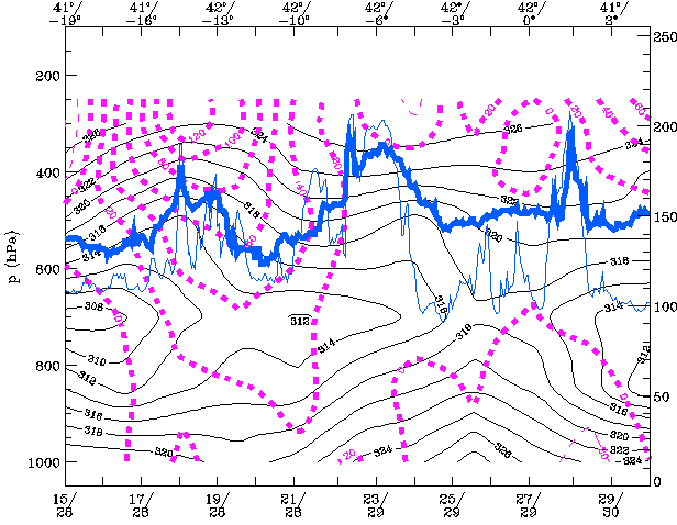
28 September 1997/00.00 UTC - Vertical cross section black thin: divergence, black thick: convergence, magenta thick: vertical motion
(omega) - upward motion, magenta thin: vertical motion (omega) - downward motion, blue thin: IR pixel values, blue thick: WV pixel
values
|
|

|
The height of the tropopause has reached its lowest values in the centre of the ULL. From now on the mature stage of the ULL is reached and the dissipation stage starts. Dry and moist air have spiralled around the centre, but generally, the area of the centre becomes increasingly moist. In the cross section strong upward motion is visible with some convergence in the coastal area of north-west Algeria; at levels above 400 hPa substantial divergence is present due to PVA in that region.
28 September 1997/12.00 UTC
|
28 September 1997/12.00 UTC - Meteosat IR image; blue: thermal front parameter (TFP) 500/850 hPa; position of vertical cross section
indicated
|
28 September 1997/12.00 UTC - Vertical cross section; black: isentropes (ThetaE), magenta: relative humidity, blue thin: IR pixel
values, blue thick: WV pixel values
|
|
|
The strongest TFP is now over Morocco, more to the west than 12 hours earlier. Cold air from the west meets warm air over northern Africa and
the horizontal gradient of the temperature in the lower levels is more or less stationary in the coastal areas. At higher levels the advection
of cold air is not so restrained (compare the cross sections of ThetaE of 28/00.00 UTC and 28/12.00 UTC).
In the cross section a very dry layer is seen around 600 hPa in the eastern part of the cross section in an area with high cloud tops. The dry
layer lies above a very deep developed unstable layer which indicates strong potential instability. In the visible image (not shown) the
reflection of short wave (solar) radiation is less in that area indicating only a thin cirrus layer.
|
26 September 1997/12.00 UTC - Meteosat IR image; green: equivalent thickness 500/850 hPa, red: height contours 500 hPa
|
26 September 1997/12.00 UTC - Vertical cross section; black: isentropes (ThetaE), magenta: relative vorticity, blue thin: IR pixel
values, blue thick: WV pixel values
|
|
|
The centre of the ULL has moved further southward while the centre of the low in thickness remains at the same position. The low is slowly
filling with moist and less cold air.
Vorticity in the centre is still strong, but less than 12 hours earlier, as can be seen in the cross sections.
|
28 September 1997/12.00 UTC - Meteosat IR image; red: height of PV=2 units
|
28 September 1997/12.00 UTC - Vertical cross section black thin: divergence, black thick: convergence, magenta thick: vertical motion
(omega) - upward motion, magenta thin: vertical motion (omega) - downward motion, blue thin: IR pixel values, blue thick: WV pixel
values
|
|
|
The highest height values of IPV=2 units (tropopause) are still located in the centre of the Upper Level Low, but the tropopause is slightly higher than 12 hours earlier. In the cross section is clear that convergence in the baroclinic zone in the area of north-west Algeria causes upward motion. Combined with the potential instability it is an area which is highly susceptible for the development of CB clusters or MCSs
Dissolution Stage and Conclusions
Synoptic situation
In the dissipation stage, warmer moister air enters the core of the ULL. This process leads to a decrease of temperature gradient and, hence, to the dissipation of the ULL.
|
29 September 1997/00.00 UTC - Meteosat IR image; green: equivalent thickness 500/850 hPa, red: height contours 500 hPa
|
29 September 1997/00.00 UTC - Surface chart; accumulated precipitation 12.00 - 00.00 UTC
|
|
|
Looking at the 500 hPa contours it can be seen that the ULL is filling. The values of equivalent thickness are increasing, indicatings that the
cold air in the core of the ULL is getting warmer.
The system can also be found on the surface chart, which is seen as a low over the Moroccan region. This is in contrast to the earlier stages,
in which the ULL was hard to find on the surface chart, also indicating that the ULL is in its dissipation stage. However, the amount of
accumulated precipitation continues to be substantial over the Gibraltar area, caused by MCSs and CB clusters in unstable air.
29 September 1997/00.00 UTC
Analysis of the system
|
29 September 1997/00.00 UTC - Meteosat IR image; blue: thermal front parameter (TFP) 500/850 hPa; position of vertical cross section
indicated
|
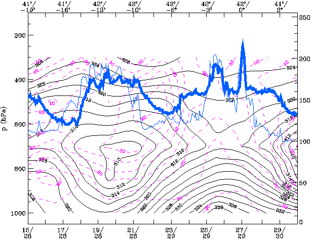
29 September 1997/00.00 UTC - Vertical cross section; black: isentropes (ThetaE), magenta: relative humidity, blue thin: IR pixel
values, blue thick: WV pixel values
|
|
|
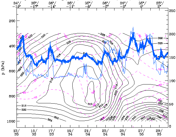
The thermal front parameter is showing cyclonically curved maxima, which coincide more or less with the cloud bands that have spiralled around the ULL.
- The isentropes are characterised by a decreasing ridge structure which represents a decrease of the temperature gradient. The isentropes of equivalent potential temperature are showing increasing values in the centre of the ULL.
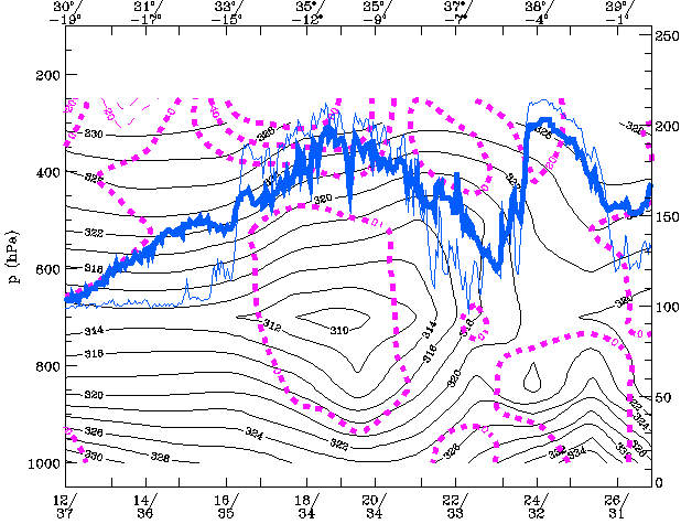
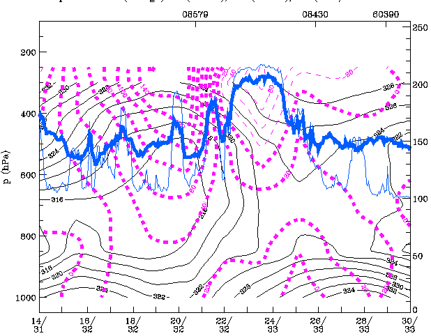
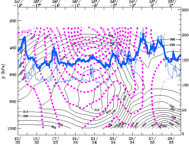
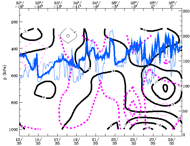
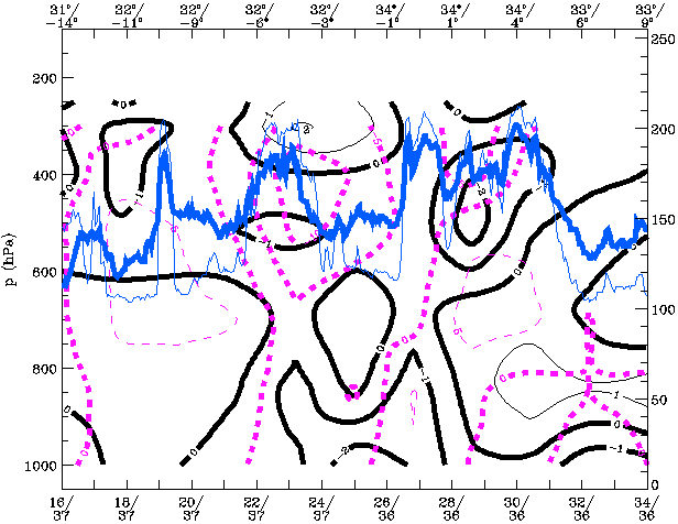
- The relative humidity shows a complex pattern with different maxima. A pronounced relative humidity maximum can be found at 3605E-3408E at around 600 hPa. This maximum coincides with the peaks in the pixel values of the WV and IR image and indicates the old CF band that is spiralling around the ULL.
- Another relative humidity maximum can be found in the layer 700-800hPa, near to the centre of the ULL at 3605W. This maximum is increasing, which means that moist air is entering the core of the ULL. The relationship with the IR and WV signal is less clear in this case.
|
29 September 1997/00.00 UTC - Meteosat IR image; blue: thermal front parameter (TFP) 500/850 hPa, cyan: vorticity 500 hPa; position of
vertical cross section indicated
|
29 September 1997/00.00 UTC - Vertical cross section; black: isentropes (ThetaE), magenta: relative vorticity, blue thin: IR pixel
values, blue thick: WV pixel values
|
|
|
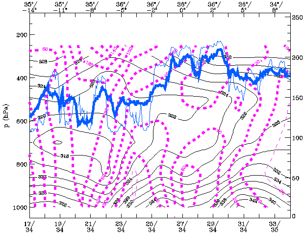
The upper air vorticity is decreasing, indicating a weakening of the cyclonic rotation of the ULL.
Low level vorticity can also be found, in contrast to previous stages. This indicates that the system is extending to the lower levels of the
troposphere.
|
29 September 1997/00.00 UTC - Meteosat IR image; red: height of PV=2 units
|
29 September 1997/00.00 UTC - Vertical cross section; black: isentropes (ThetaE), magenta: relative vorticity, blue thin: IR pixel
values, blue thick: WV pixel values
|
|
|
The WV image shows distinct cyclonically curved bands of moist and dry air. Besides the cold air features the centre of the ULL is dark grey to
black, indicating dry (stratospheric) air. The intense white spots are MCS's and Cb clusters, which are embedded in airmasses with high
humidity and conditionally unstable stratification of the troposphere.
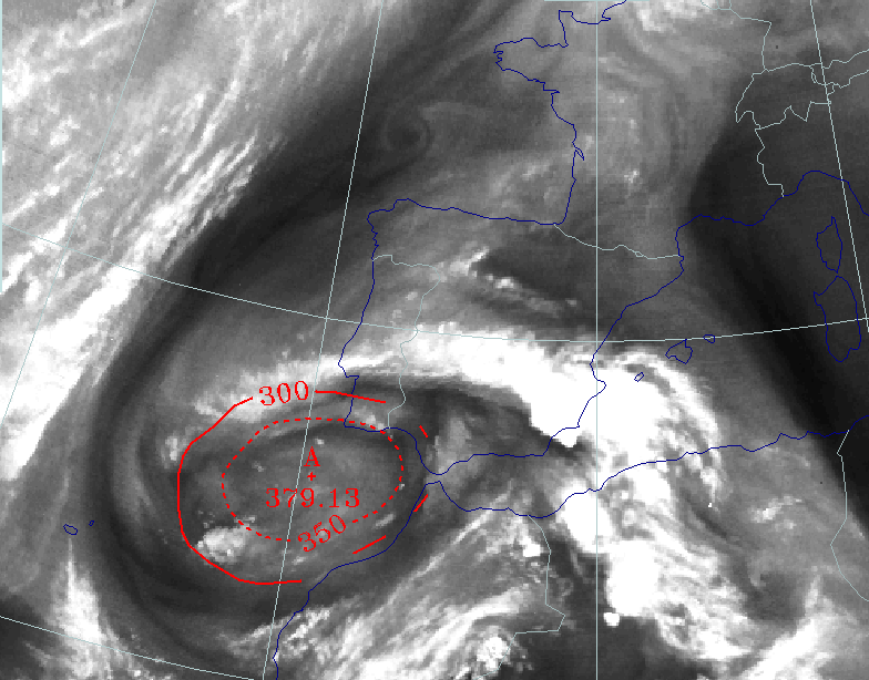
The height of PV = 2 is increasing, which indicates a warming of the air in the centre of the ULL.
In the cross section, a pronounced area of vertical motion can be seen which coincides with the unstable airmass that appears to the right side
of the ULL over the coastline of NW Morocco.
30 September 1997/00.00 UTC
|
30 September 1997/00.00 UTC - Meteosat IR image; blue: thermal front parameter (TFP) 500/850 hPa; position of vertical cross section
indicated
|
30 September 1997/00.00 UTC - Vertical cross section; black: isentropes (ThetaE), magenta: relative vorticity, blue thin: IR pixel
values, blue thick: WV pixel values
|

|
|
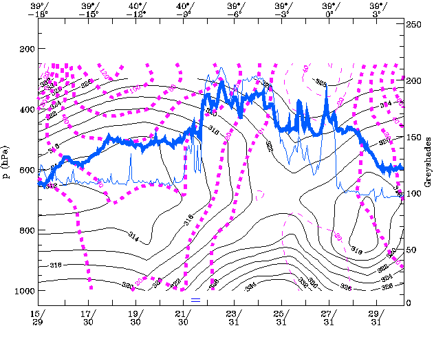
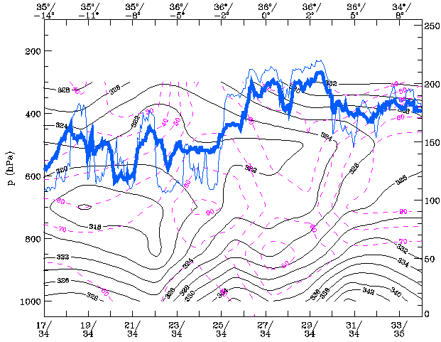
Moister air enters the core of the ULL. Again, the thermal front parameter shows cyclonically curved maxima, which coincide more or less with
the cloud bands that have spiralled around the ULL.
The isentropes of equivalent potential temperature are showing increasing values in the centre of the ULL. The Equivalent Potential Temperature
has increased by 6K in the core of the ULL.
Two maxima of relative humidity can be found. This indicates the old frontal cloud band, which has spiralled around the ULL. It can also be
seen that moister air enters the core of the ULL, further indicating the dissipation of the ULL. However the relationship between the WV and IR
pixel values is not easily seen. It seems that the system iis not well detected by the numerical model.
|
30 September 1997/00.00 UTC - Meteosat IR image; green: equivalent thickness 500/850 hPa, red: height contours 500 hPa; position of
vertical cross section indicated
|
30 September 1997/00.00 UTC - Vertical cross section; black: isentropes (ThetaE), magenta: relative humidity, blue thin: IR pixel
values, blue thick: WV pixel values
|
|
|
The image shows that the ULL continues to fill. The 500 hPa contours are showing increasing values in the centre of the ULL (568 gpdam 29/00.00
UTC 572 gpdam at 30/00.00 UTC). The values of equivalent thickness are increasing, indicating that the cold air in the core of the ULL is
getting warmer.
Values of upper air vorticity are decreasing, indicating a weakening of the cyclonic circulation. Remarkably, the vorticity at lower levels is
increasing, which means that the lower level system is becoming more pronounced (See also Synoptic Situation).
|
30 September 1997/00.00 UTC - Meteosat IR image; red: height of PV=2 units
|
30 September 1997/00.00 UTC - Vertical cross section; black: isentropes (ThetaE), magenta: relative humidity, blue thin: IR pixel
values, blue thick: WV pixel values
|
|
|
The WV image shows two vortices, which can be seen in the cloudbands that are spiralling around two centers. The height of PV = 2 units is
increasing further to 293 hPa (i.e. the height of the tropopause is increasing), indicating a warming of the air in the centre of the ULL.
A pronounced maximum of vertical velocity can be detected at 500 hPa. This maximum doesn't coincide with the maximum pixel values of the WV and
IR. Again, the numerical model does not detect the situation well.
Conclusions
The Upper Level Low, as analysed here, is a classical type and has all the characteristics of the Conceptual Model described in the Manual.
In this case the reactivation of an already existing Upper Trough west of Portugal by a fast moving unstable Wave from the west, known in
literature as "trigger", was important. This was most significant at the top of the troposphere. This trough part of the Wave
brought a new injection of cold, descending air with stratospheric origin. The merging of the two troughs was the start of the tear-off/cut-off
process.
Cold air was transported around the centre of the ULL and met warm continental air over the Iberian Peninsula and north-west Africa. The
advection of cold air was most pronounced at upper levels and therefore instability was increasing during the process. The "clash"
with the warmer continental air not only caused frontogenisis, but was also the start of heavy convective activity in forms of CBs, CB clusters
and MCS triggered by convergence in the baroclinic zones. This process persisted for several days, especially the cut-off and dissipation
stages. Most of the precipitation occurred in the dissipation stage and was caused by (embedded) showers from an MCS and, therefore, the
amount of precipitation differed significantly from place to place. Most of the precipitation was concentrated over north Morocco and southern
Spain. Model forecasts for the amounts and location of rainfall were very inconsistent as is often the case with convective precipitation.
During the cut-off stage the descending troposheric air with high PV values came to its lowest level with the tropopause just above 400hPa in
the centre of the ULL.
The sinking air was responsible for diabatic heating and is one of the reasons for the "filling" of the low.
Another reason was the horizontal advection of moist and warmer air which spiralled into the centre whilst releasing latent heat in the
condensation process. During the whole life cycle the vorticity extended more and more down in the troposphere and in the dissipation stage a
surface low appeared below the centre of the ULL.
References
- BADER M. J., FORBES G. S., GRANT J. R., LILLEY R. B. E. and WATERS A. J. (1995): Images in weather forecasting - A practical guide for interpreting satellite and radar imagery; Cambridge University Press
- BLUESTEIN H.B. Synoptic Dynamic Meteorology in Midlatitudes - Volume I Principles of Kinematics and Dynamics; Oxford University Press.
- BLUESTEIN H.B. Synoptic Dynamic Meteorology in Midlatitudes - Volume Obeservations and Theory of Weather Systems; Oxford University Press.
- HOSKINS B. J., MCINTYRE M. E. and ROBERTSON A. W. (1985): On the use and significance of isentropic potential vorticity maps; Quart. J. R. Meteor. Soc., Vol. 111, p. 877 - 946
- HOSKINS B. J. (1991): Towards a PV - Theta view of the general circulation; Tellus, Vol. 43 AB, p. 27 - 35
- MARTIN F., ELIZAGA F., RIOSALIDO R., Servicio de Tecnicas de Analisis y Prediccion (STAP) Instituto Nacional de Meteorologia (INM), C/Paseo de las Moreras s/n, Ciudad Universitaria, Madrid E_28071, Spain (1999): The Mushroom configuration in water vapour imagery and operational applications. Meteorol. Apl. 6 143-154 (1999)