Table of Contents
- I. Introduction
- II. The pre-frontal convergence line 29 May
- Synoptic scale analysis at 06.00 UTC
- Satellite images
- Weather events
- Model Analyses - Cross sections
- Model Analyses - Relative streams
- Model Analyses - LAM model output
- III. Introduction
Introduction
This case study relates to the special case of the Pre-frontal convergence line of the Non-orographic convergence line conceptual model
presented in SATMANU. (see
Conceptual Models: Non-Orographic Convergence Lines
). The object of this particular study is a convergence line which developed ahead of a Cold Front over Poland during 29 May 2000. Some
convective cloud cells already existed in the morning, but the actual convergence line started developing in the afternoon. When the
development starts it is very rapid and the convergence line contains several mature cells of deep convection. Rain and thunderstorms are
reported in many locations near the line. In the evening, when development has reached its peak, one can no longer distinguish the frontal
cloud band from the thick convergence clouds.
The purpose of this study is to investigate the circumstances which caused this particular pre-frontal convergence line to develop and to
compare them with those typical of the conceptual model Non-orographic Convergence Line.
Synoptic scale analysis at 06.00 UTC
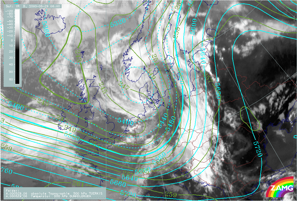
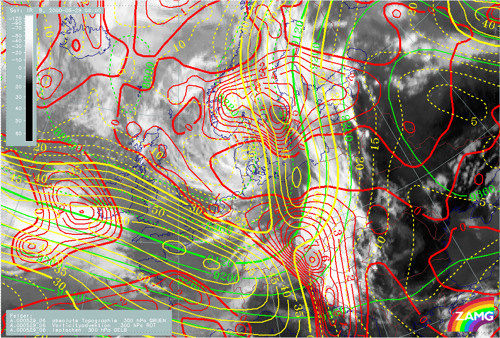
As the synoptic situation concerning this case does not change significantly during the day, it is convenient to begin by making a thorough analysis of the situation at 06.00 UTC. This is done by studying the ECMWF model analysis together with Meteosat satellite images. The geopotential height and the temperature at 500 hPa at 06.00 UTC show that there is distinct cold advection over eastern Germany and Poland. A corresponding wide area of warm advection extends from the Gulf of Finland to northern Norway. A 300 hPa jet is present in an east to southeast direction from the English Channel towards north of the Alps, and then turns north to Scandinavia. There is polar air mass in the area of the 500 hPa trough over the North Sea, the Atlantic and the British Isles. Furthermore, there is a tongue of mid-latitude (warmer) air extending from the Black Sea northwards in the area of the 500 hPa ridge.
|
29 May 2000/06.00 UTC - Meteosat IR image; green: temperature 500 hPa, cyan: height contours 500 hPa
|
29 May 2000/06.00 UTC - Meteosat IR image; green: height contours 300 hPa, red: positive vorticity advection (PVA) 300 hPa, yellow:
isotachs 300 hPa
|
|
|
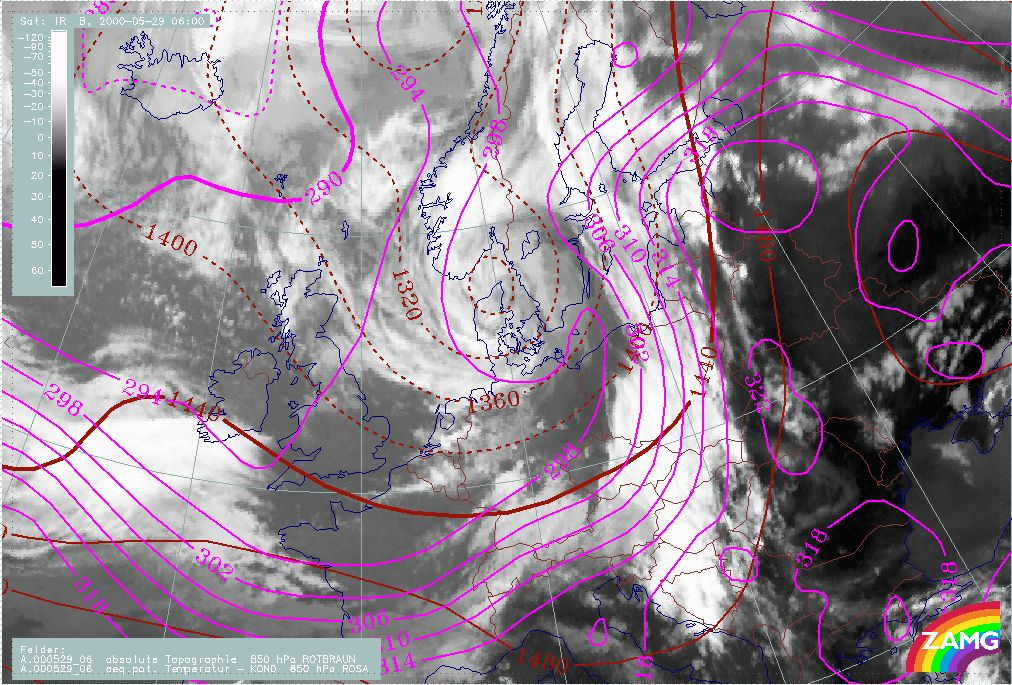
A very sharp gradient in equivalent potential temperature can be seen. This is characteristic of a distinct Cold Front and there is frontal cloudiness extending from the Baltic Sea in the north to Slovenia and Croatia in the south. Across the Gulf of Finland and southern Finland there is also a distinct temperature gradient, indicating a Warm Front. Moreover there is a thermal ridge with very warm air in the region to the east of the Cold Front; equivalent potential temperatures reach 322K.
|
29 May 2000/06.00 UTC - Meteosat IR image; magenta: equivalent potential temperature 850 hPa, brown: height contours 850 hPa
|
|
|
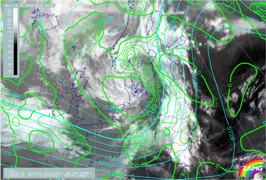
In the area of the Cold Front cloud bands there is pronounced positive vorticity advection at both 300 hPa and 500 hPa, especially over the # southern part of the Cold Front, which is situated immediately ahead of the 500 hPa trough. However, ahead of the frontal cloud band, vorticity advection is small or even negative.
|
29 May 2000/06.00 UTC - Meteosat IR image; cyan: height contours 500 hPa, green: positive vorticity advection (PVA) 500 hPa
|
|
|
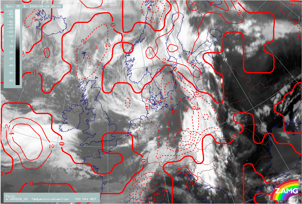
Temperature advection at 700 hPa shows pronounced cold advection over eastern Germany and Poland, underlining the fact that there is a Cold Front there, while the warm advection in the area of southern Finland is less pronounced. Immediately ahead of the frontal cloud band, there is some warm advection, indicating the existence of a Warm Conveyor Belt.
|
29 May 2000/06.00 UTC - Meteosat IR image; red: temperature advection 700 hPa
|
|
|
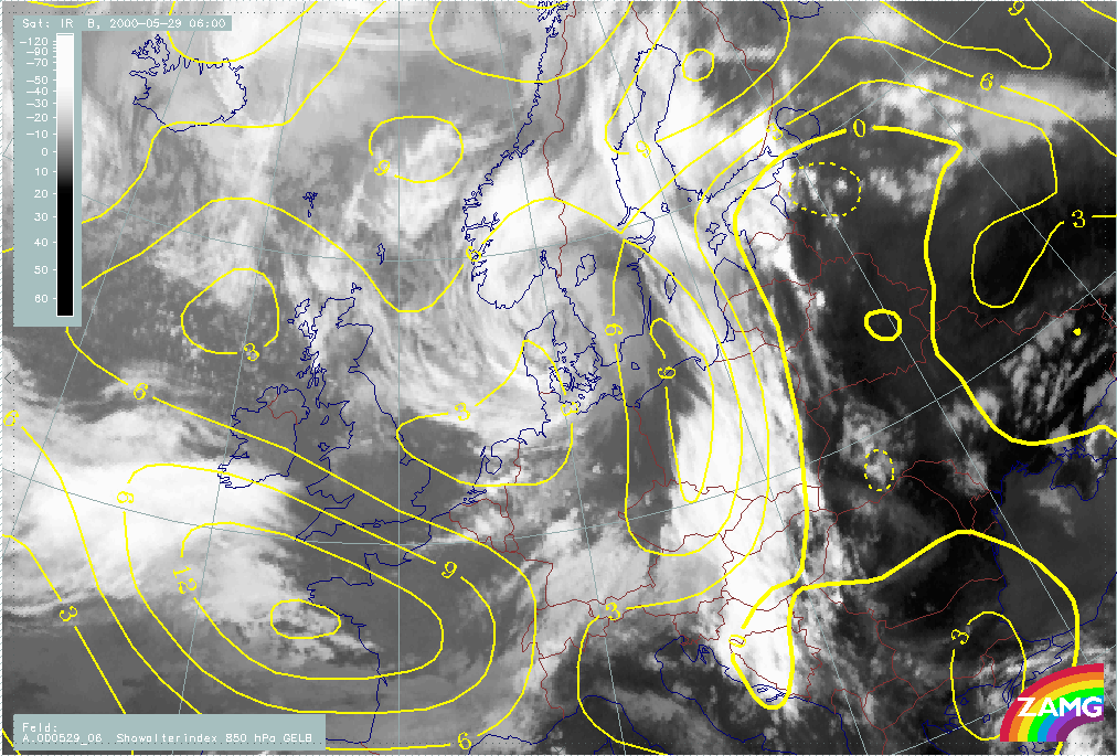
The Showalter index has values less than zero over a large part of the thermal ridge, east of the Cold Front. This means that severe thunderstorms are very likely in this region.
|
29 May 2000/06.00 UTC - Meteosat IR image; yellow: Showalter index
|
|
|
All in all, the most characteristic feature of the synoptic situation at 06.00 UTC is a pronounced Cold Front. Ahead of this front, there is a thickness ridge containing very warm air. To the rear (west) of the thickness ridge there is some warm advection. Thus the meteorological circumstances are very similar to those for pre-frontal convergence lines.
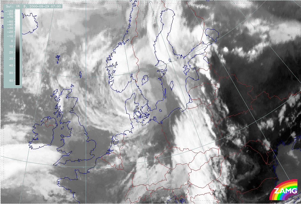
Satellite images
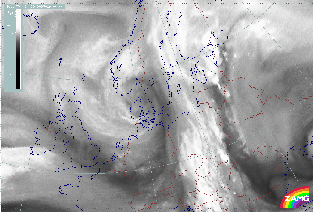
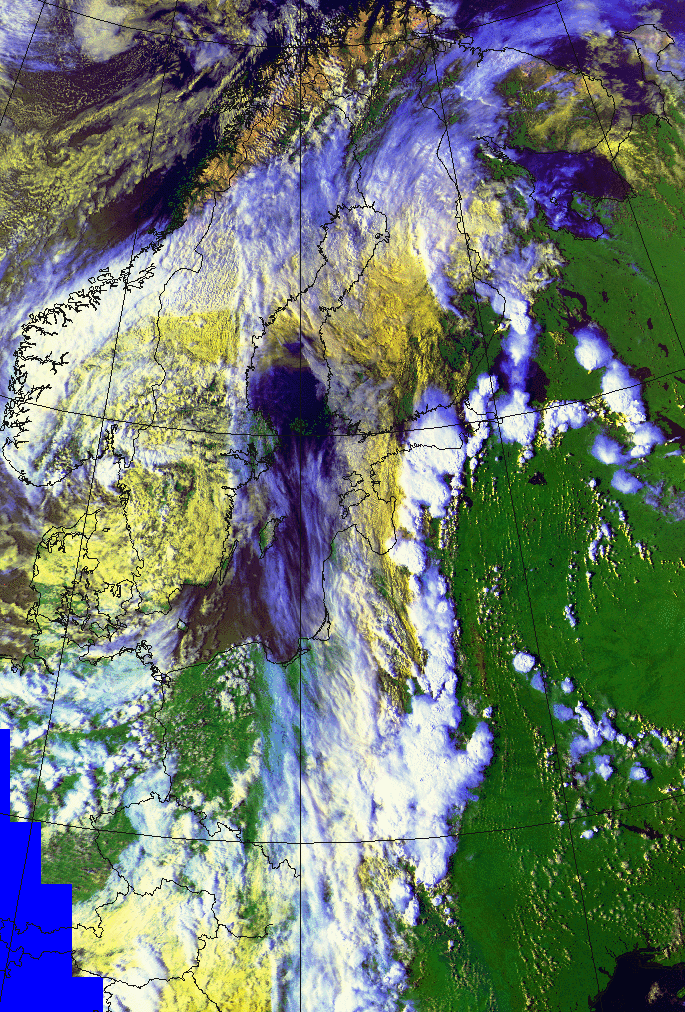
The development of the convergence line is well depicted in satellite images. The Meteosat infrared image reveals that there are some convective cloud cells over Poland, slightly ahead of the frontal cloud band, at 06.00 UTC. The Meteosat water vapour image at 06.00 UTC shows the existence of actually two Convergence Lines. Drier area is located between the Convergence Lines, which is seen as a darker north-south oriented region, roughly along 25E. In this special case the visual appearance differs slightly from a typical Non-orographic convergence line (see Conceptual Models: Non-Orographic Convergence Lines ) in which there is only one Convergence Line, clearly separate from the frontal cloud band. Furthermore, a bright and very moist frontal zone is clearly seen in the water vapour image.
|
29 May 2000/06.00 UTC - Meteosat IR image
|
29 May 2000/06.00 UTC - Meteosat WV image
|

|

|
In the NOAA satellite image (at 06.43 UTC) the two Convergence Lines are more clearly seen; the first one being quite a modest feature and
located immediately at the leading edge of the frontal cloud band, while another is located further east. The frontal cloud band is shown as
yellow in the NOAA image (generally low clouds) in the eastern part and white or bluish white (thick or high clouds) in the western part. This
means that the thickness of the frontal cloud layer grows towards west. Hence, the NOAA image shows a marked partition between the low clouds
at the leading edge of the frontal cloud band and the convergence clouds ahead of the front.
The Meteosat water vapour image at 06.00 UTC shows the partition between the two Convergence Line quite clearly, as there is a dry area between
them, seen as a darker region lying in a north-south direction. The two Convergence Lines are also clearly seen as brighter regions in this
image. Furthermore there is a bright and very moist frontal zone.
|
29 May 2000/06.43 UTC - NOAA RGB image (channel 1, 2 and 4)
|
|
|
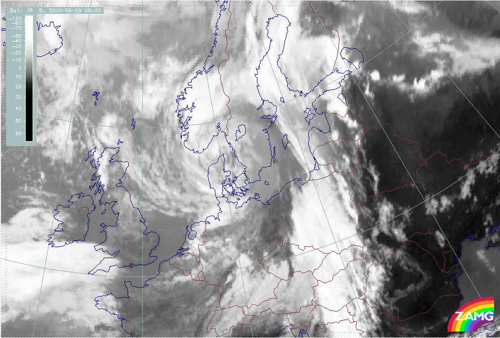
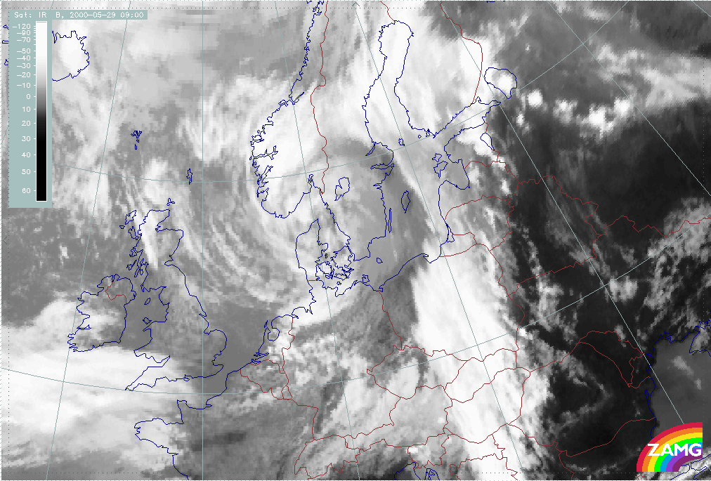
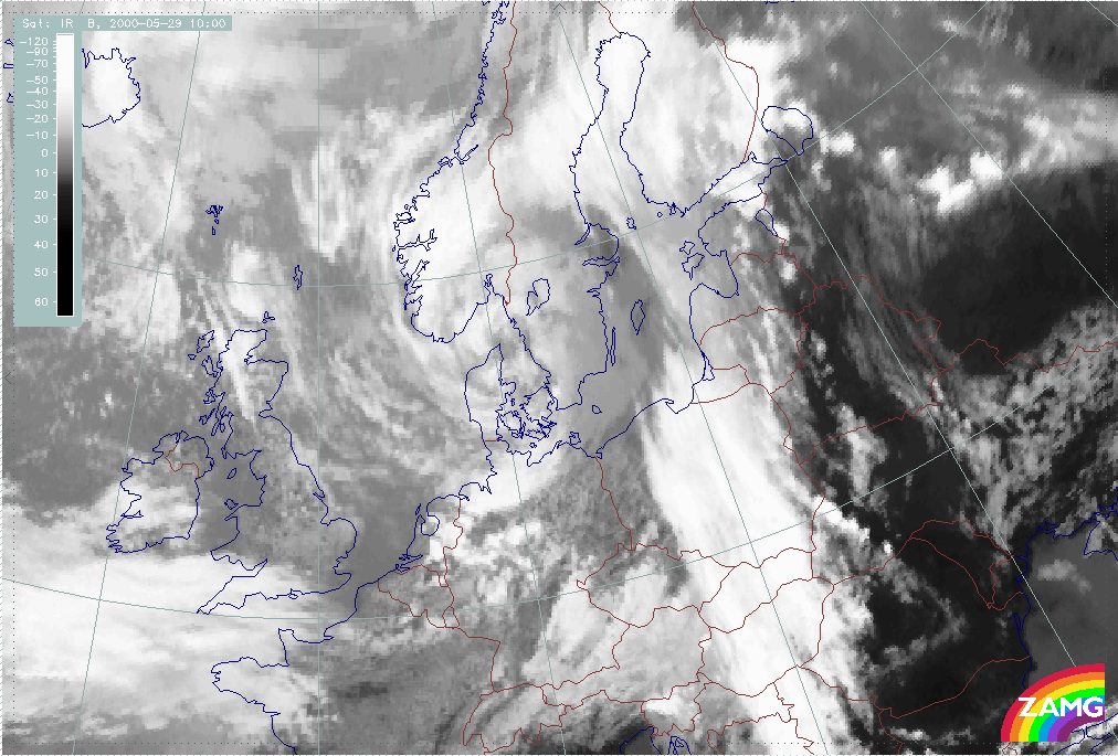
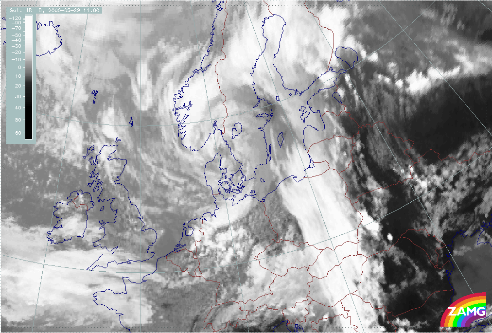
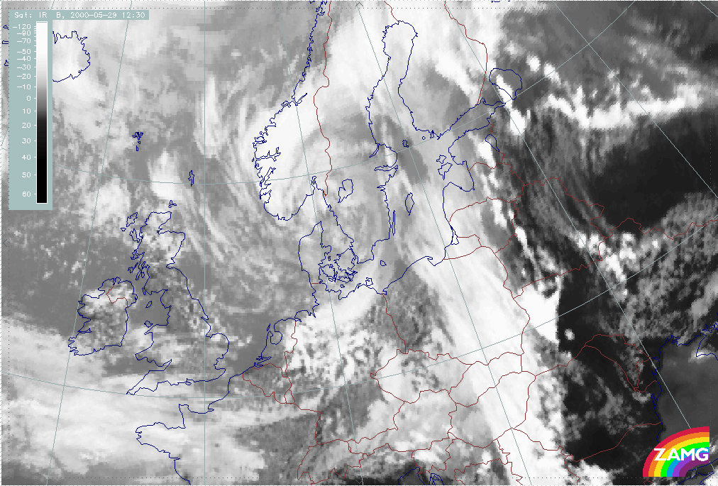
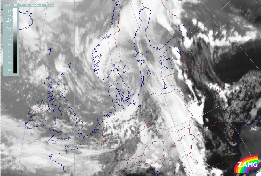
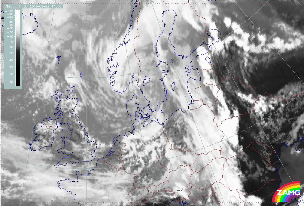
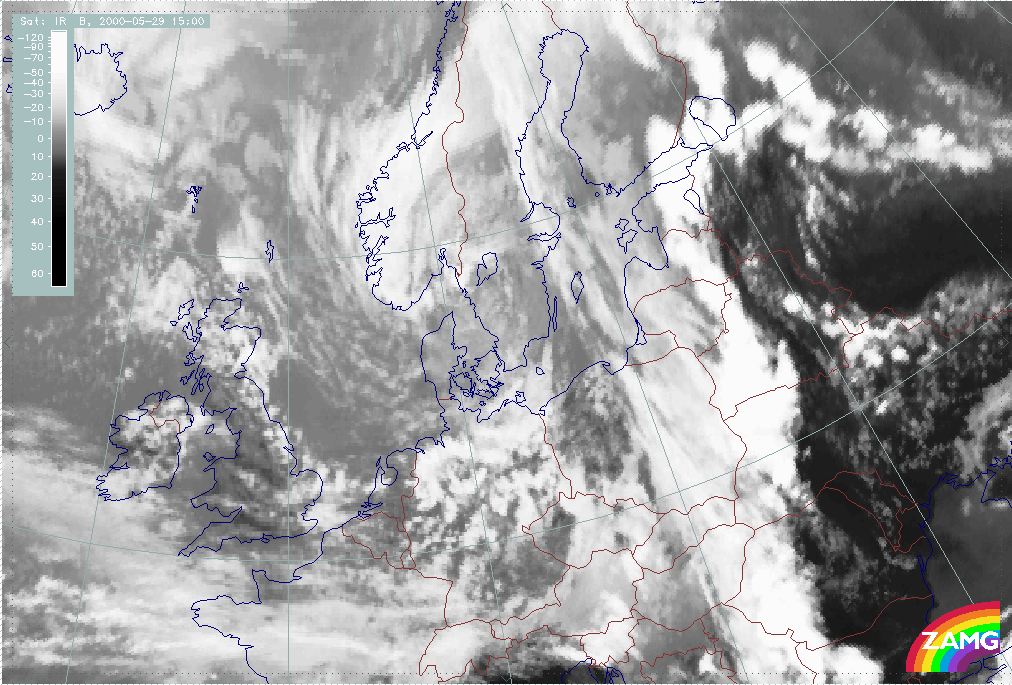
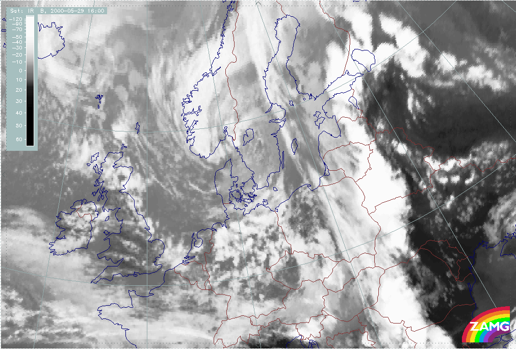
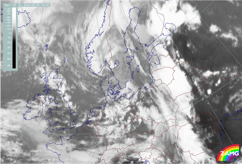
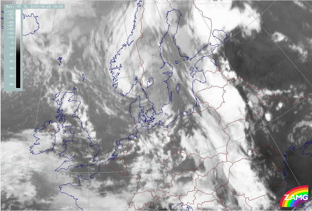
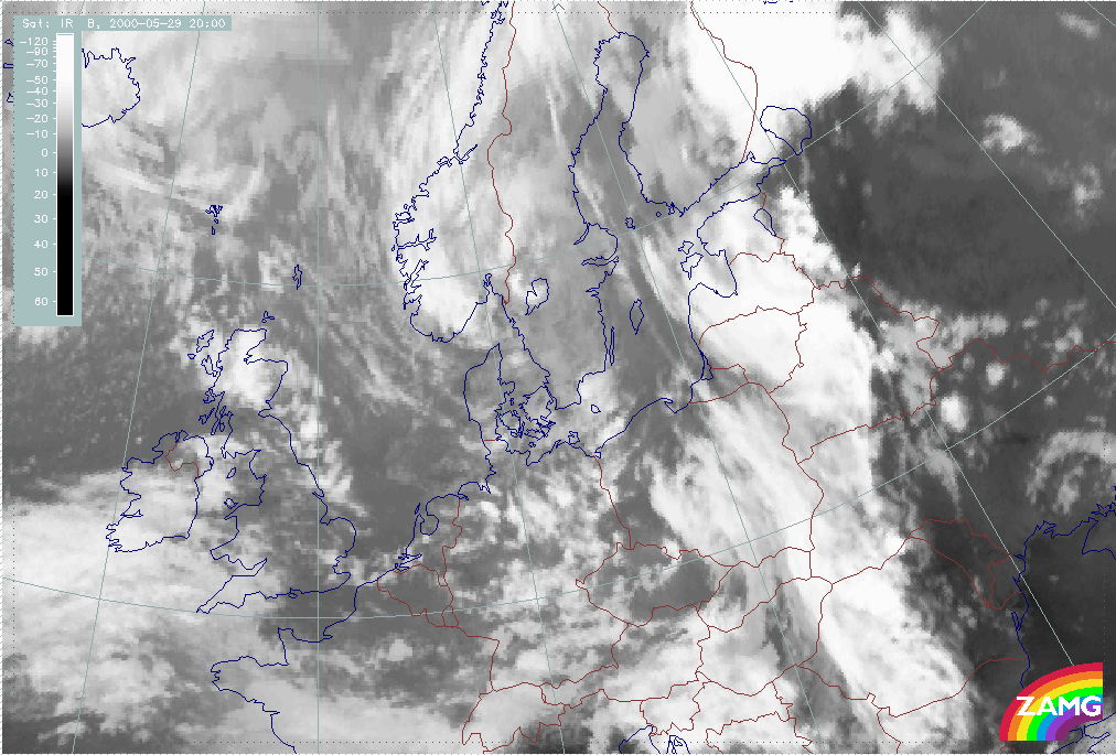
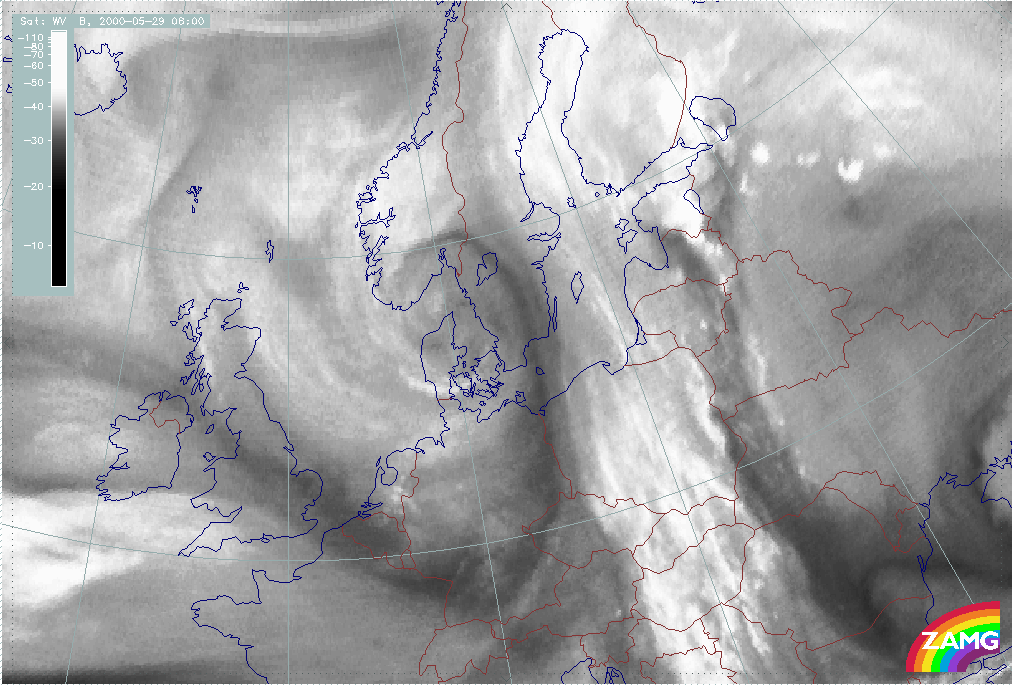
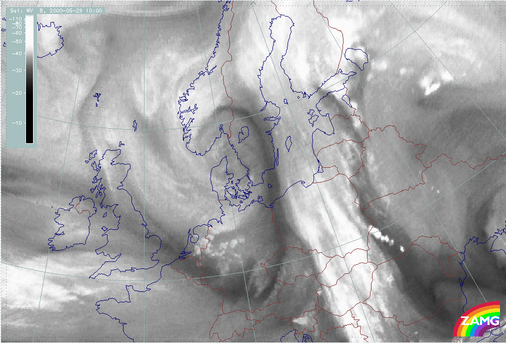
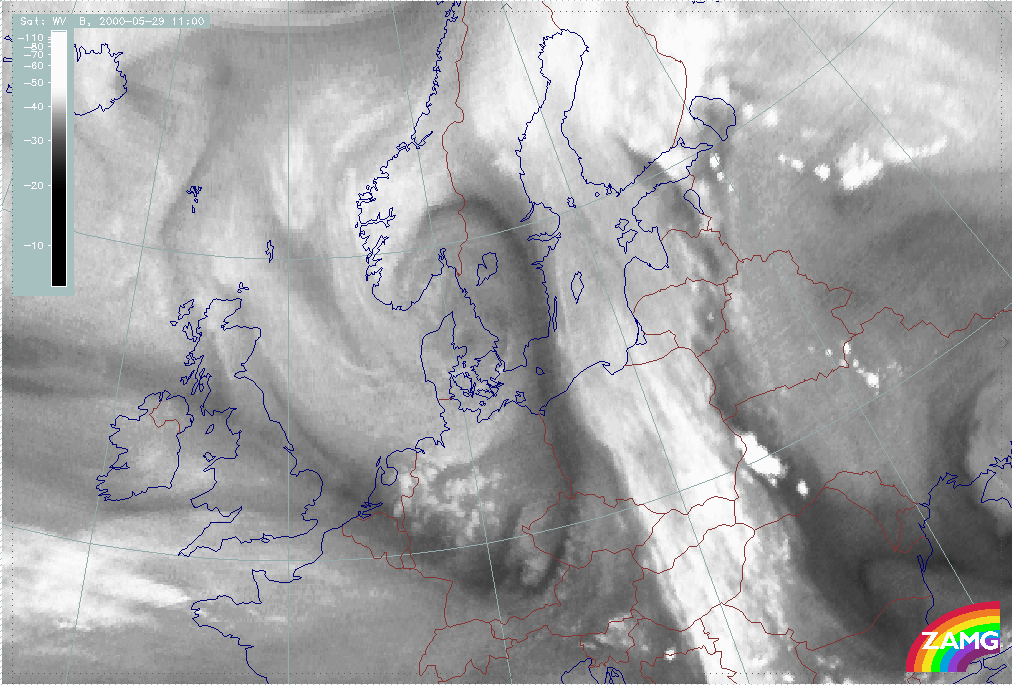
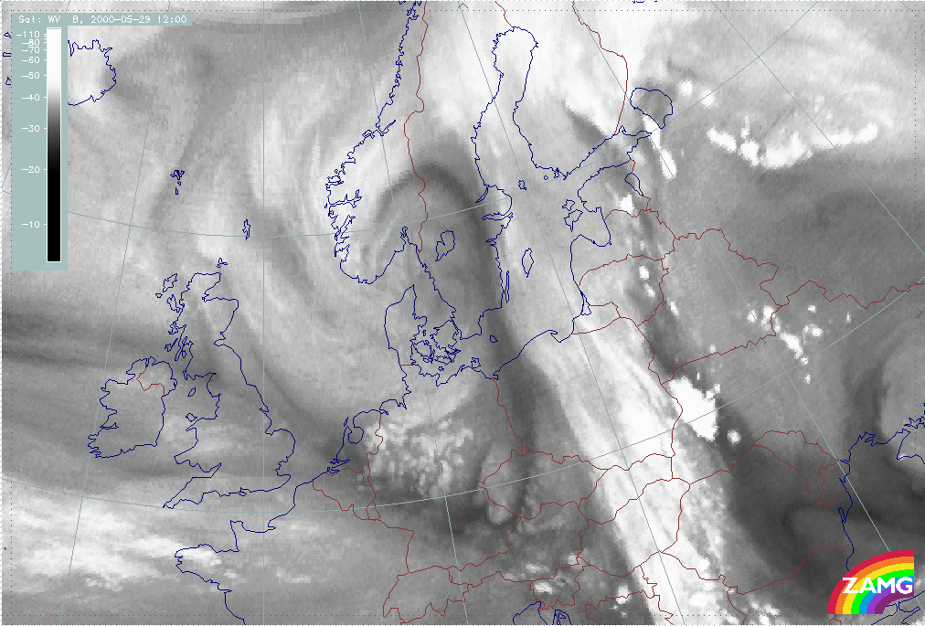
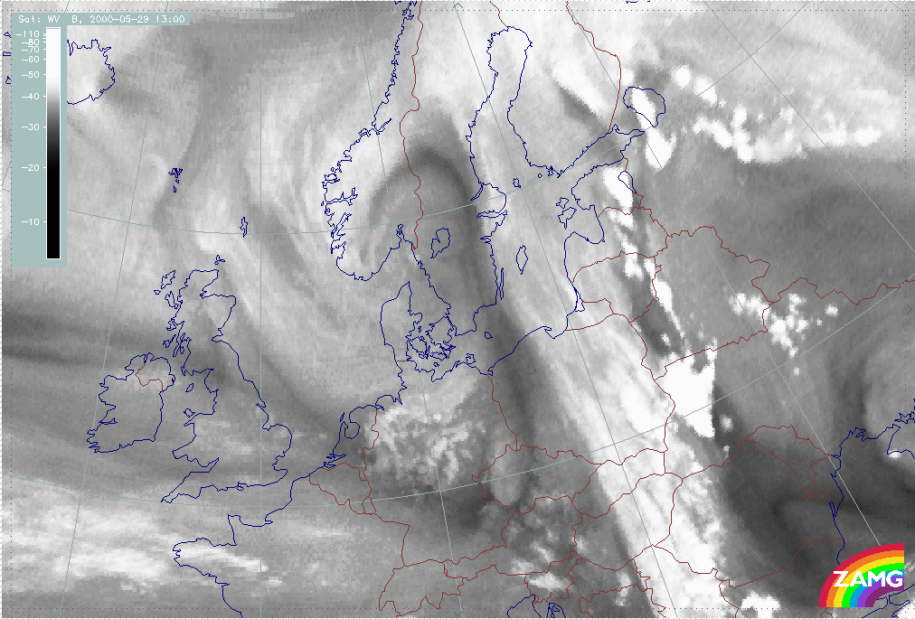
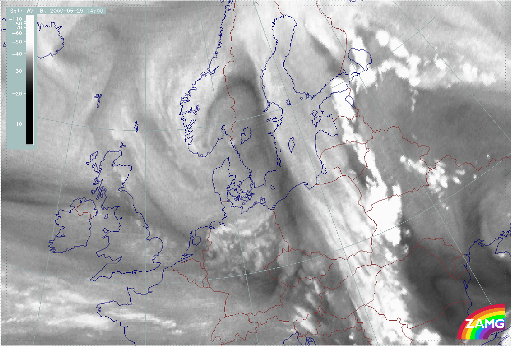
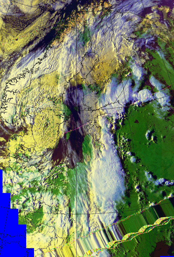
The situation at 12.00 UTC differs only slightly from that at 06.00 UTC. The frontal cloud band seems a bit weaker and the convergence line situated to the east of the front at 06.00 UTC has moved away northeast and weakened during this period of time (this is seen in the Meteosat image sequences below). Furthermore, the convective cells immediately ahead of the Cold Front are more pronounced than at 06.00 UTC. At this point in time the Convergence Line starts developing significantly. The Meteosat image sequences below show the development throughout the day. The rapid convective development starting at about 12.00 UTC is clearly seen in both the infrared and the water vapour sequences. It is clearly recognised how the convective cells at the leading edge of the frontal cloud band grow substantially between 12.00 and 13.00 UTC.
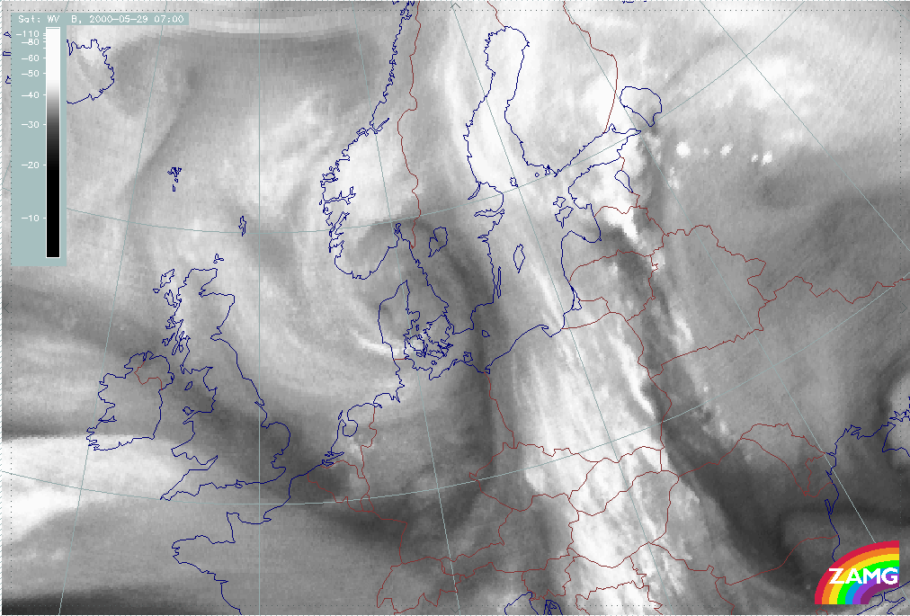
Water vapour imagery also shows the most rapid development between 12.00 and 14.00 UTC. It starts on the boundary between moist and dry air (most clearly seen at 13.00 UTC around 55N/26E). This feature is likely to be connected to Fair Weather Convectivity (see Convective cloud features in typical synoptic environments: Fair Weather Conditions ).
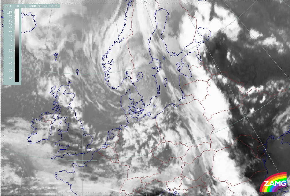
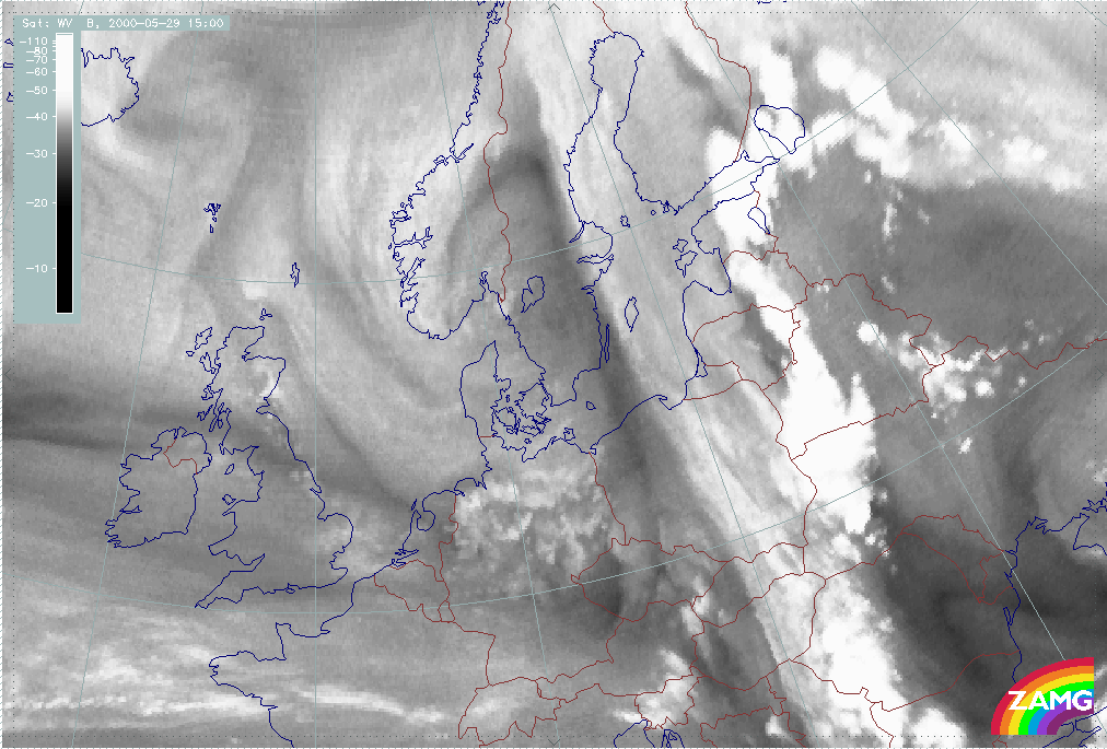
The Convergence Line continues to grow larger by the hour. However, the frontal clouds seem to gradually fade away. By 17.00 UTC, the Convergence Line, with large cumulonimbus clouds, dominates the frontal cloud band. Within this region there is a thick layer of very deep clouds.
|
29 May 2000/06.00 UTC - Meteosat IR image; 06.00 - 20.00 UTC hourly image Loop
|
29 May 2000/06.00 UTC - Meteosat WV image; 06.00 - 15.00 UTC hourly image Loop
|
The NOAA images provide more details. The anvils of the cumulonimbus clouds are seen as bluish clouds at the edges of the bright cores of the cumulonimbus clouds. The western boundary of the convergence clouds, on the other hand, is yellowish indicating thet lower frontal clouds exist beneath the thick convective cloud layer at 13.10 and 14.29 UTC. At 16.34 UTC these clouds can still be distinguished, although they are much weaker than a couple of hours earlier. Further to the west there are still some bluish high clouds belonging to the Cold Front.
|
29 May 2000/13.10 UTC - NOAA RGB image (channel 1, 2 and 4)
|
29 May 2000/14.29 UTC - NOAA RGB image (channel 1, 2 and 4)
|
|
|
|
|
|
29 May 2000/16.34 UTC - NOAA RGB image (channel 1, 2 and 4)
|
|
As a conclusion to this subchapter, one can say that the development of the Convergence Line ahead of the Cold front is quite typical at first, when the convective cloud cells are growing in a line near the leading edge of the Cold front in the beginning of the afternoon. The explosive development later on is rather unusual. One reason for this behaviour could be some kind of interaction with the old Convergence Line, which is seen in the satellite images at 06.00 UTC and then moves towards northeast and fades away during the day.
Weather events
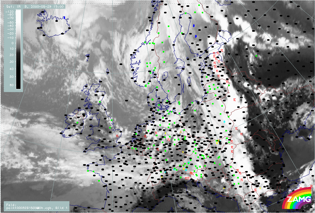
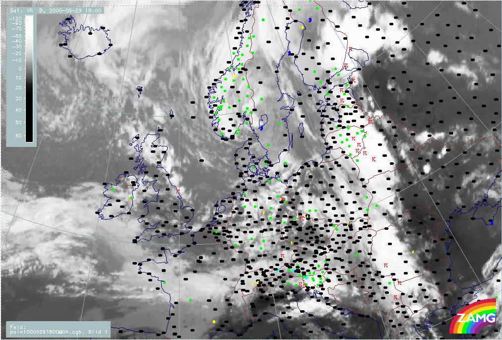
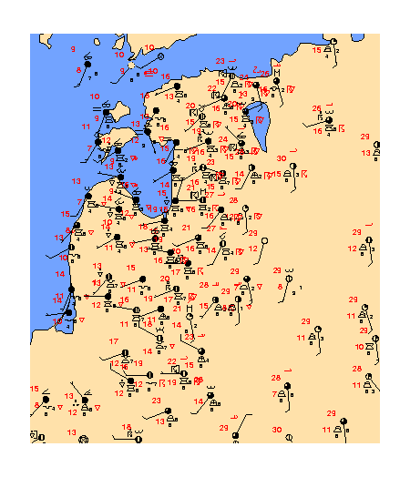
The main weather events during the day are an increasing number of thunderstorms along the Convergence Line and some precipitation in the region of the Cold Front cloud band. The images below show the weather events in detail, based upon synoptic observations at 12.00, 15.00 and 18.00 UTC. At 12.00 UTC there are only a few thunderstorms reported along the Convergence Line, while there is quite a lot of precipitation in the region of the Cold Front. At 15.00 UTC the situation has changed such that there are many thunderstorms and slightly fewer observations of precipitation alone. By 18.00 UTC, precipitation is again observed more widely, while there are only a few thunderstorms. The thunderstorms are located along a line, exactly at the position of the pre-frontal Convergence Line. Thus the weather events observed are very similar to the typical ones.
|
29 May 2000/06.00 UTC - Meteosat IR image; weather events (green: rain and showers, blue: drizzle, cyan: snow, red: thunderstorm with
precipitation, purple: freezing rain, orange: hail, black: no actual precipitation or thunderstorm with precipitation)
|
29 May 2000/15.00 UTC - Meteosat IR image; weather events (green: rain and showers, blue: drizzle, cyan: snow, red: thunderstorm with
precipitation, purple: freezing rain, orange: hail, black: no actual precipitation or thunderstorm with precipitation)
|

|
|
|
|
|
29 May 2000/18.00 UTC - Meteosat IR image; weather events (green: rain and showers, blue: drizzle, cyan: snow, red: thunderstorm with
precipitation, purple: freezing rain, orange: hail, black: no actual precipitation or thunderstorm with precipitation)
|
|
A map of full synoptic observations at 12.00 UTC is shown below. The converging wind field is clearly seen (the direction of the wind differs by as much as 90 degrees between neighbouring observation stations at the position of the Convergence Line). Furthermore, the very warm and moist air ahead of the Cold Front is also clearly seen. Temperatures reaching almost 30 degrees centigrade and dewpoints exceeding 15 degrees can be observed over quite an extensive clear area ahead of the Cold Front. The air immediately behind the front is substantially cooler, with temperatures of about 15 degrees centigrade.
|
29 May 2000/12.00 UTC - Synoptic observations; black: Surface temperature, red: dewpoint, green: present weather
|
|
|
Model Analyses - Cross sections
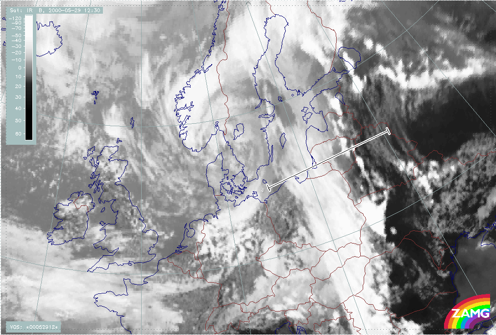
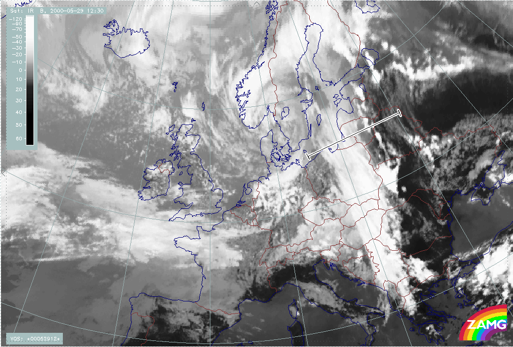
In this section the thermodynamic circumstances important for the development of the pre-frontal Convergence Line will be investigated. This is done mainly by using vertical cross-sections based on ECMWF analyses, however the Aladin model analysis is used to some extent. The cross-sections presented below are all made along the line shown in the image below. This line lies approximately west - east, across the whole weather system, and includes both the Cold Front and the Convergence Line. The equivalent potential temperature and the brightness of the Meteosat infrared and water vapour channels are shown in all the cross-sections presented below, in addition to some other parameters of interest.
|
29 May 2000/12.30 UTC - Meteosat IR image; position of vertical cross section indicated
|
|
|
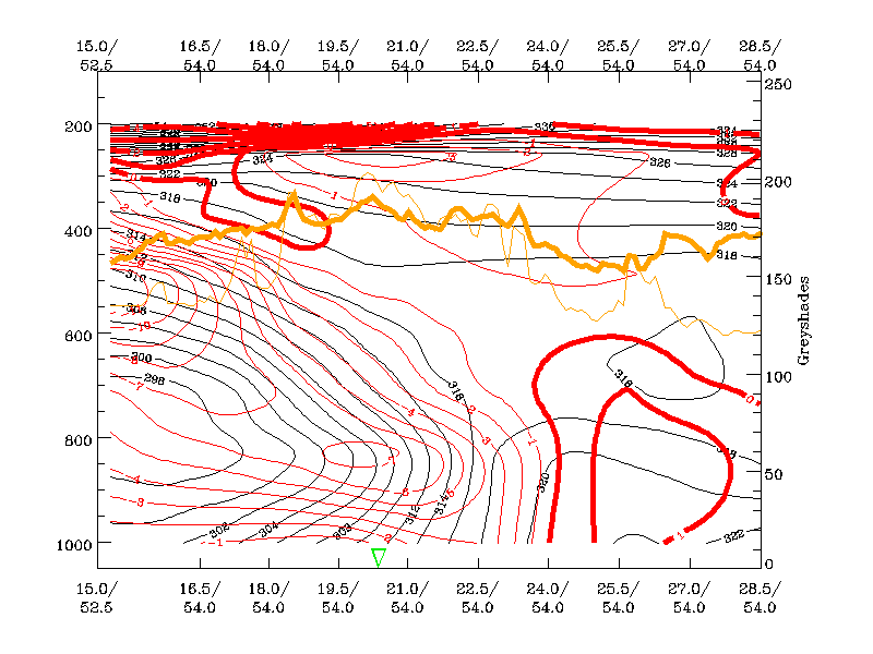
The gradient zone of isentropes of equivalent potential temperature, which is seen in the region of the Cold Front cloud band, highlights the frontal surface, that is the border between the polar and the mid-latitude air mass on each side of the Cold Front. At 06.00 UTC, for instance, the isentrope of 318K lies above the frontal surface. The clouds of both the pre-frontal Convergence Line and the Cold Front are clearly seen as peaks in brightness of the infrared channel (thin orange line). The Convergence Line is located at the peak in brightness values at approximately 26 degrees east, while the frontal cloud band is located more to the west, in the broad region of high brightness values.
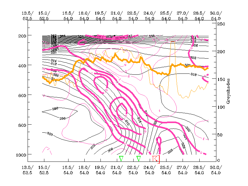
It can be seen at both 06.00 UTC and 12.00 UTC that there is warm advection ahead of the front. At 06.00 UTC the warm advection extends from the surface up to 600 hPa, the maximum being little more than 1 K/12 hours at approximately 900 hPa. The cold advection of the Cold Front is also clearly seen. There are two maxima of cold advection at 06.00 UTC, both situated behind the frontal surface, one at 800 hPa, the other at 500 hPa. The magnitude of the cold advection is about -10 K/12 hours, which is clearly larger, in absolute values, than that of the warm advection. Furthermore there is weak cold advection at upper levels ahead of the Cold Front.
|
29 May 2000/06.00 UTC - Vertical cross section; black: isentropes (ThetaE), red thin: temperature advection - CA, red thick:
temperature advection - WA, orange thin: IR pixel values, orange thick: WV pixel values
|
|
|
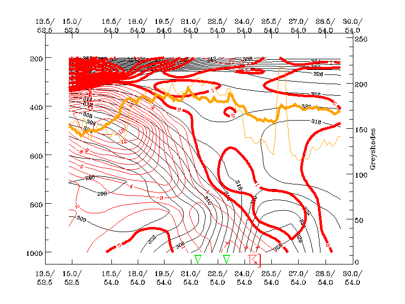
At 12.00 UTC the warm advection covers virtually the whole region in front of the frontal surface, exhibiting two rather distinct maxima, which both are a little over 2 K/12 hours. One is situated at 800 hPa at the position of the Convergence Line, the other situated further to the west along the frontal surface at approximately 650 hPa. The strong cold advection behind the Cold Front does not differ significantly from that seen at 06.00 UTC. The front does not move that much during this period of time. The temperature gradient across the Cold Front, near the surface, is much more pronounced at 12.00 UTC than at 06.00 UTC.
|
29 May 2000/12.00 UTC - Vertical cross section; black: isentropes (ThetaE), red thin: temperature advection - CA, red thick:
temperature advection - WA, orange thin: IR pixel values, orange thick: WV pixel values
|
|
|
The cross sections reveal that the warmest air is situated immediately ahead of the front at both 06.00 and 12.00 UTC. This very warm air is, in effect, a Warm Conveyor Belt, and its location fits well with that of the Convergence Line. Additionally, an important fact is that the equivalent potential temperature of the air ahead of the Cold Front is even 8 K higher at 12.00 UTC than at 06.00 UTC. Solar radiation is an important contributor here, as the temperature advection at 06.00 UTC is only about 1 K/12 hours. However, the warming of the air near the surface contributes essentially to the destabilisation of the air column ahead of the Cold Front. This is brought out by the fact that equivalent potential temperature is decreasing much more clearly with height at 12.00 UTC than at 06.00 UTC. This indicates larger potential instability. While the equivalent potential temperature field is only slightly unstable at 06.00 UTC, it is clearly unstable up to about 650 hPa at 12.00 UTC. Weak cold advection in the upper levels at 06.00 UTC also contributes to this development.
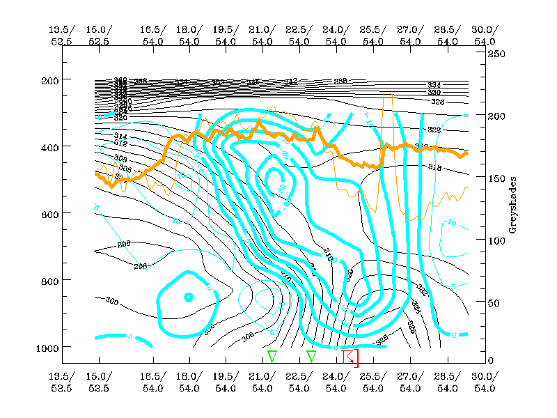
Cross-sections of divergence and omega at 12.00 UTC are presented below. It can be seen that convective development is quite well shown by the model analysis. There is convergence at the position of the Convergence Line reaching up to approximately 800 hPa, the maximum being near the surface. Another maximum of convergence is situated along the frontal surface, further to the west, at 700 hPa, and is clearly a frontal feature. A divergence maximum is seen ahead of the frontal surface at high levels and weak divergence is also seen behind the front at about 800 hPa.
|
29 May 2000/12.00 UTC - Vertical cross section; black: isentropes (ThetaE), magenta thin: divergence, magenta thick: convergence,
orange thin: IR pixel values, orange thick: WV pixel values
|
|
|
The omega field reflects the convergence field. There is upward motion in a wide area ahead of the frontal surface, exhibiting two maxima; one ahead of the front at 800 hPa and the other along the frontal surface at 500 hPa. Moreover, the upward motion extends through a thick layer, especially at the position of the Convergence Line, where upward motion is seen reaching throughout the troposphere. The magnitude of the upward motion at the convergence line is about -20 hPa/hour, which is a very small value compared to the typical updraft of 1-10 m/s in convective clouds (Puhakka 1995). The reason for this is that the resolution of the model analysis is insufficient to catch the small scale, strong updraft of a developing convective cloud. However, qualitatively, the upwardmotion is represented well.
|
29 May 2000/12.00 UTC - Vertical cross section; black: isentropes (ThetaE), cyan thick: vertical motion (omega) - upward motion, cyan
thin: vertical motion (omega) - downward motion, orange thin: IR pixel values, orange thick: WV pixel values
|
|
|
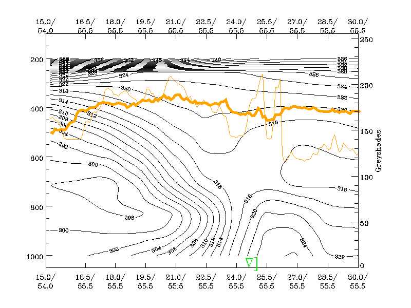
Model Analyses - Relative streams
The relative streams are calculated at two isentropic levels. The heights of these levels can be seen in the cross section image below, the location of cross section shown in the image above it. The lower isentropic level, 310K, represents the air flow within the cold frontal layer, whereas the upper isentropic level 318K represents the air flow above the frontal layer.
The relative streams at both levels show hardly any cold air moving from behind the Cold Front into the region of the Convergence Line at upper levels. The limiting streamline in the upper levels is well within the cold front cloud band. Thus, the cold air stream from behind the front cannot contribute significantly to the development of convection. The pre-frontal convergence, at least in this case, is not triggered by over-running cold air advection (as in the case of Kata Cold Fronts), but rather by processes in the warm air ahead of the Cold Front.
|
29 May 2000/12.30 UTC - Meteosat IR image; position of vertical cross section indicated
|
29 May 2000/12.00 UTC - Vertical cross section; black: isentropes (ThetaE), red thin: temperature advection - CA, orange thin: IR pixel
values, orange thick: WV pixel values
|
|
|
|
|
|
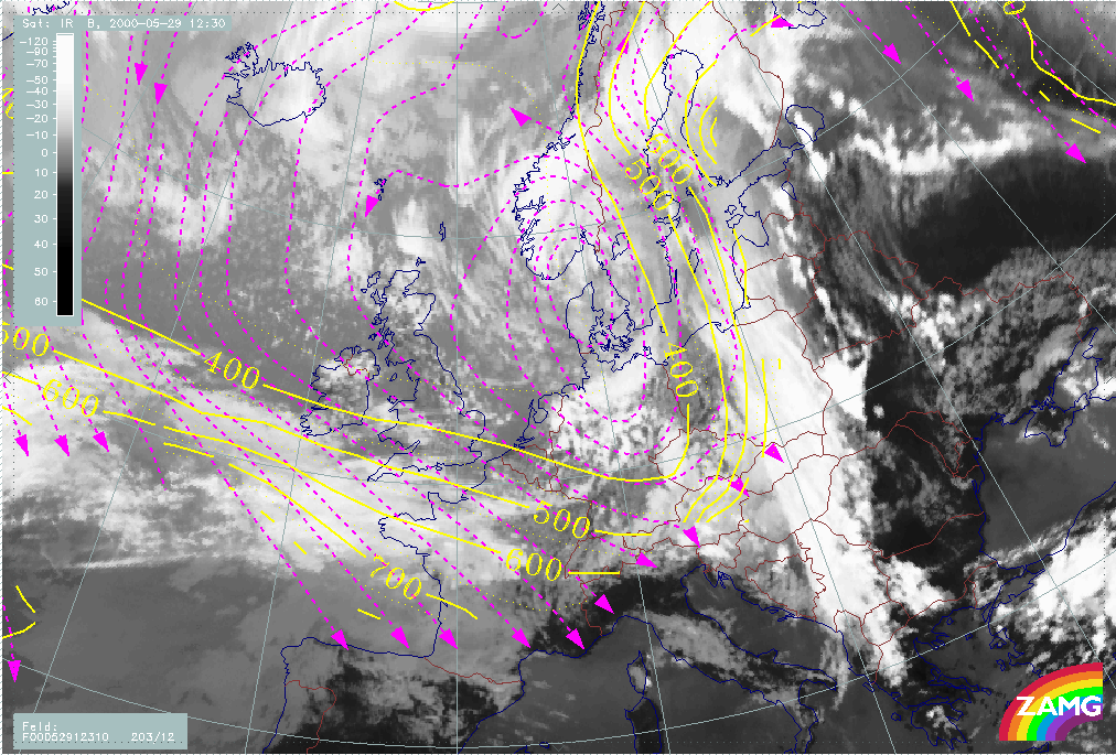
29 May 2000/12.30 UTC - Meteosat IR image; magenta: relative streams 310K - system velocity: 203° 12 m/s, yellow: isobars
|
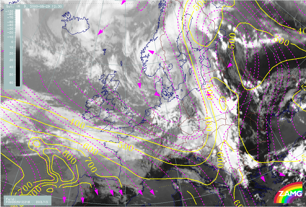
29 May 2000/12.30 UTC - Meteosat IR image; magenta: relative streams 318K - system velocity: 203° 13 m/s, yellow: isobars
|
Model Analyses - LAM model output
ECMWF model data used so far has performed fairly well in showing the general features of this pre-frontal Convergence Line. After all, a global model should not be expected to show the fine structure of the Convergence Line. For this, a high-resolution limited area model (LAM) may bring additional and more detailed information about the Convergence Line.
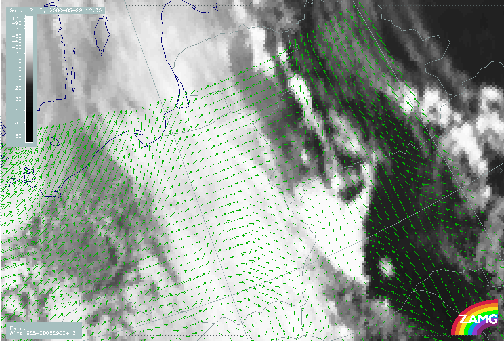
The wind field at 925 hPa, from the Aladin analysis used here, provides a good description of some of the important processes associated with the development of the Convergence Line. The convergence near the surface ahead of the frontal cloudiness is clearly seen as the wind direction changes by about 90 degrees almost exactly at the Convergence Line. Furthermore the Warm Conveyor Belt bringing in warm air from the south-southeast is revealed by the wind vectors ahead of the Cold Front.
|
29 May 2000/12.30 UTC - Meteosat IR image; green: wind vectors 925 hPa
|
|
|
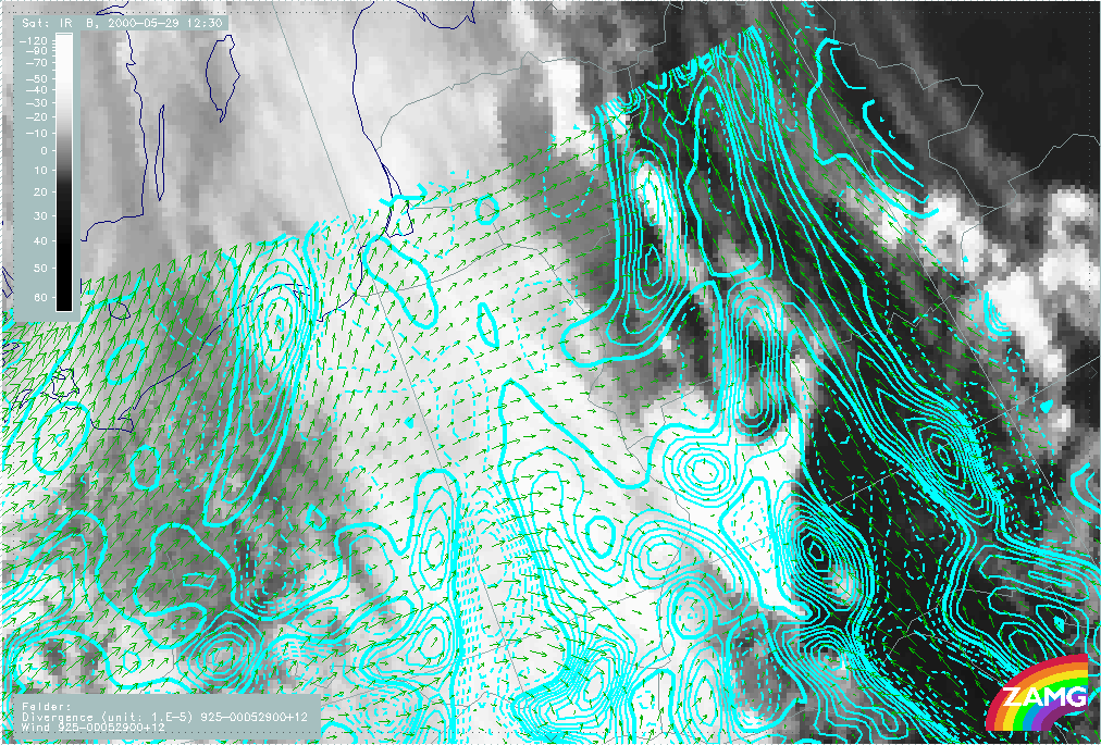
Additionally the divergence and omega fields of the Aladin analysis capture the general features of the Convergence Line quite well. In fact, the Aladin analyses of divergence and omega fields even show a clear cellular structure. However, the convection cells are displaced by the analysis, as it fails to show correctly the small scale features of, for instance, the updraft in the developing Convergence Line.
|
29 May 2000/12.30 UTC - Meteosat IR image; cyan solid: convergence 925 hPa, cyan dashed: divergence 925 hPa, green: wind vectors 925 hPa
|
29 May 2000/12.00 UTC - Meteosat IR image; yellow solid: upward motion 925 hPa, yellow dashed: downward motion 925 hPa, green: wind
vectors 925 hPa
|
|

|
In this section some differences have been shown, when compared to the typical circumstances of pre-frontal convergence lines. The upward motion of this Convergence Line, for instance, exists throughout the troposphere, which is very high compared to the typical upward motion reaching about 700 hPa. In spite of this, the convergence ahead of the front is quite normal, reaching about 800 hPa. The warm advection ahead of the Cold Front, on the other hand, is more pronounced than usual, while there is essentially no cold relative stream from behind at upper levels.
Summary and references
The pre-frontal Convergence Line of this case study develops to the rear of an equivalent thickness ridge, as a pronounced Cold Front approaches from the west. A well developed Warm Conveyor Belt, containing very warm air, is located ahead of the Cold Front. As solar radiation heats the air of the Warm Conveyor Belt further during the day, the air column ahead of the Cold Front becomes clearly potentially unstable. Hence strong convection starts in the afternoon, triggering several cells of deep convection with heavy rain and thunderstorms. This development is seen very well in both the Meteosat and NOAA satellite images, but the NOAA images provide much more detail. The convergence ahead of the Cold Front reaches from the surface up to 800 hPa, which is a typical property of such a Convergence Line. The omega field, on the other hand, differs from the typical case, as upward motion is seen reaching throughout the whole troposphere. The triggering mechanism releasing the potential unstability remains unclear, but the most important contributor in this case seems to be the strong differential heating by solar radiation in combination with a pronounced Warm Conveyor Belt.
References
- Puhakka T., 1995: Pilvifysiikka. Lecture notes, University of Helsinki