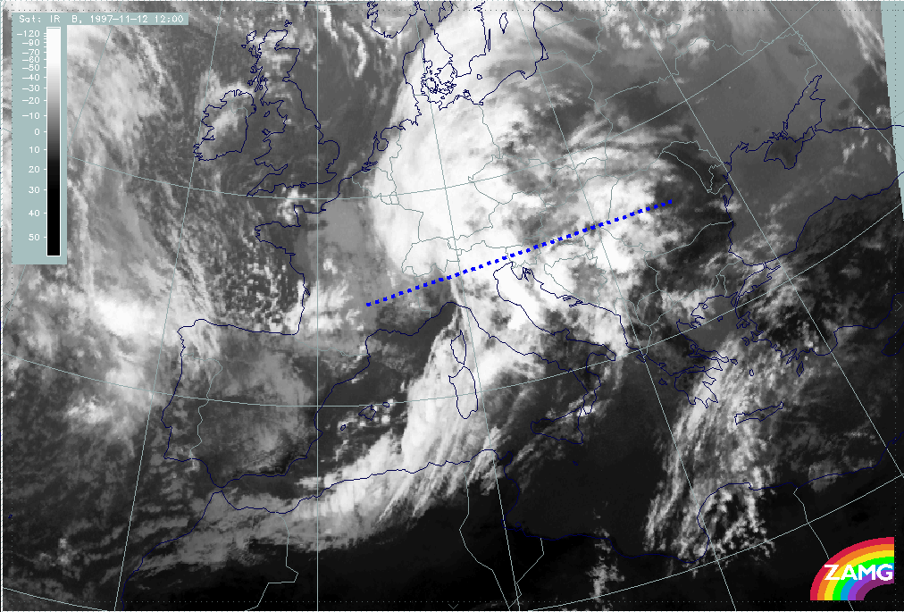
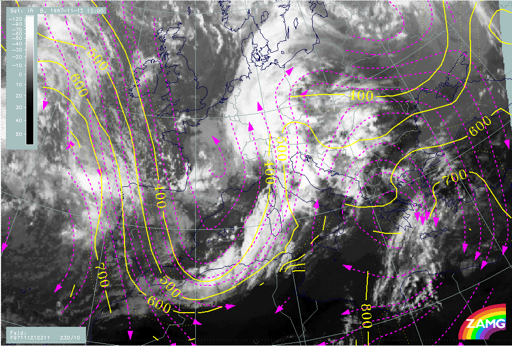
Table of Contents
- I. Synoptic Situation for 12 November 06.00 UTC
- Overview and frontal diagnosis
- Wave development in the area Sardinia - Corsica
- Intensification of frontal cloudiness and activity by jet streak crossing
- Cloudiness over Italy and the Balkan peninsula in front of the Cold Front: Relative Streams
- II. Development During the next 12 Hours
- Frontal displacement with help of the Thermal Front Parameter
- Displacement of the Wave
- Front Intensification by Jet Crossing
- III. Synoptic Situation for 12 November 12.00 UTC
- Overview and new aspects
- Diagnosis of front and Wave(s)
- Relative streams: Cloudiness over the Balkan peninsula
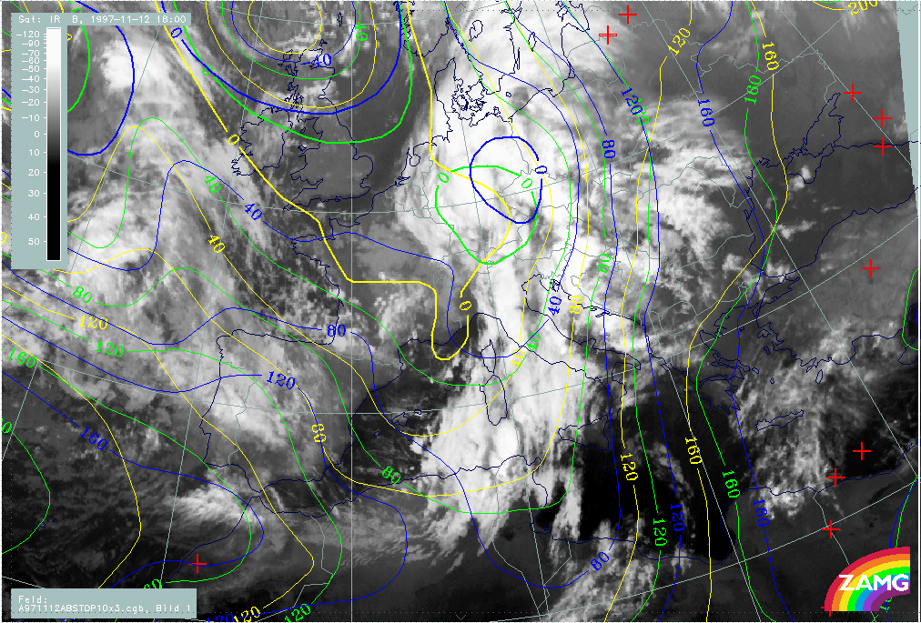
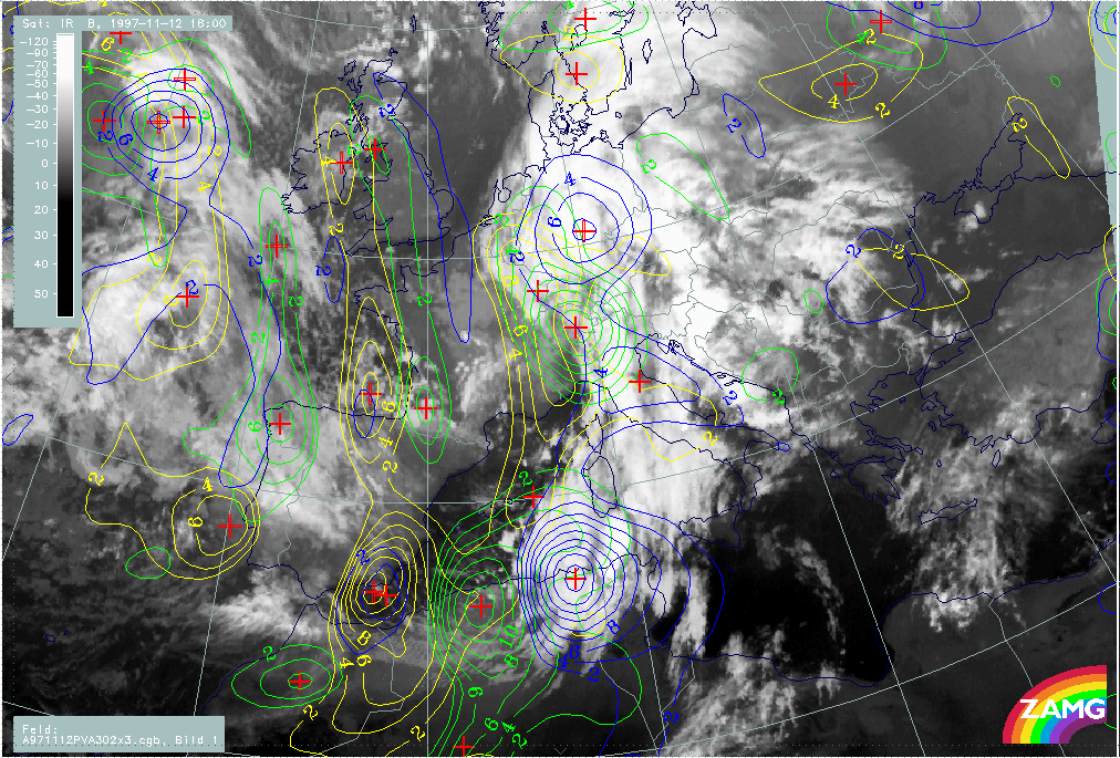
- IV. Synoptic Situation for 12 November 18.00 UTC
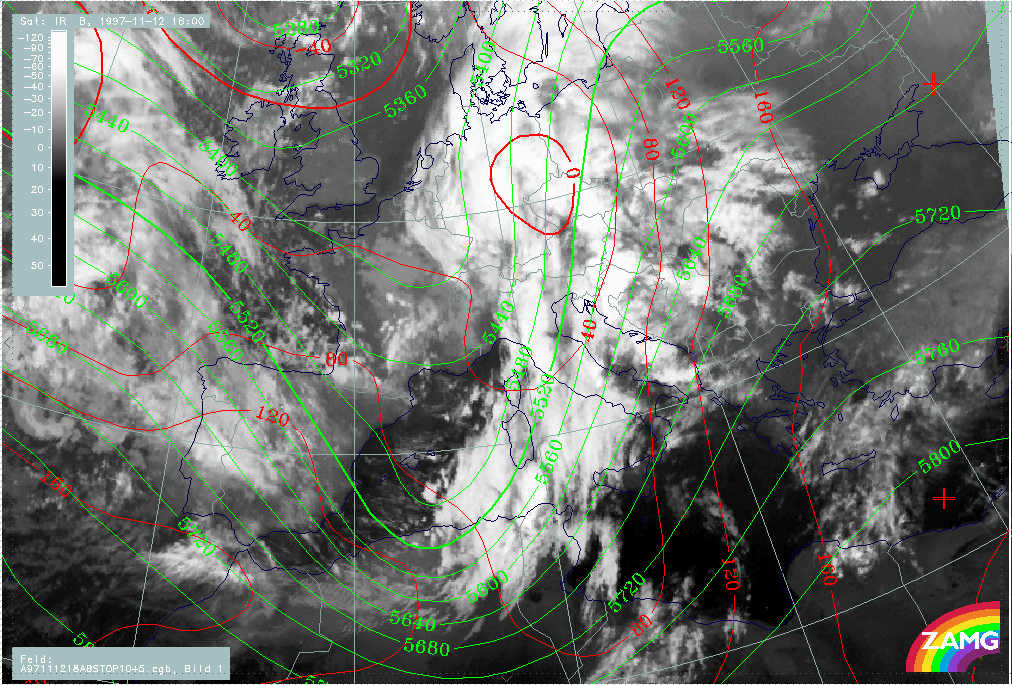
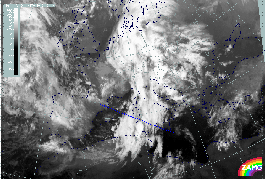
- Comparison of cloud configurations between 12.00 and 18.00 UTC
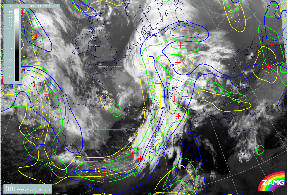
- Overall situation and frontal diagnosis
- Relative streams
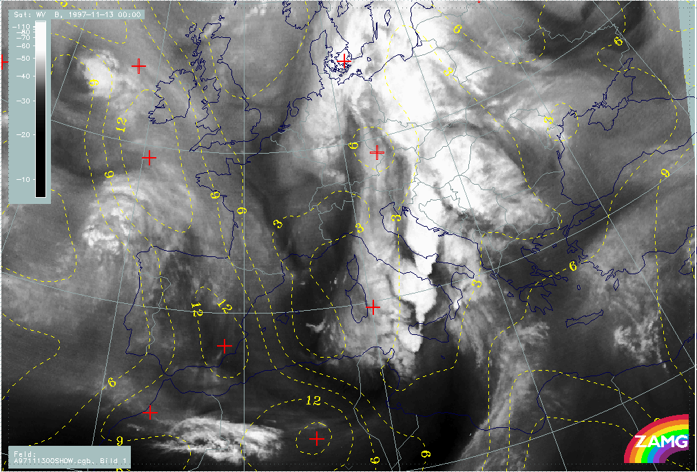
- V. Synoptic Situation for 13 November 00.00 UTC
- Introduction for 13 November 00.00 UTC
- Overview and frontal situation
- Relative streams: Frontal and pre-frontal situation
- VI. Development of Thunderstorms and MCSs During the Whole Period
- Introduction for the diagnosis of conceptual modles for convective developments
- The period 12 November 05.00 - 07.00 UTC
- The period 12 November 11.00 - 12.00 UTC
- The period 12 November 14.00 - 18.30 UTC
- The period 12 November 21.00 UTC - 13 November 00.00 UTC
- Some summarizing ideas
Overview and frontal diagnosis
Besides the overall diagnosis of conceptual models there are three main topics:
- Wave Sardinia - Corsica - Italy
- Front Intensification by Jet Crossing south-east Spain
- Cloudiness in front of Cold Front: relative streams
Thunderstorms and their synoptic environment are discussed in a separate chapter (compare Development of Thunderstorms and MCSs During the Whole Period).
|
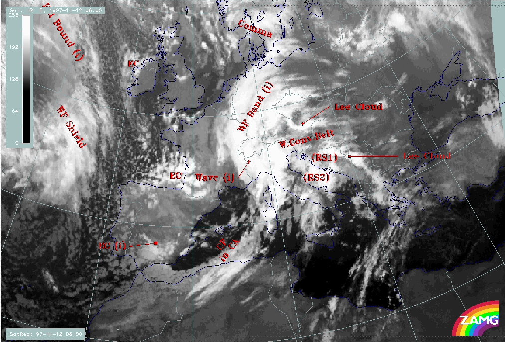
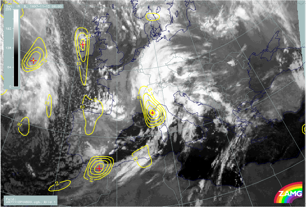
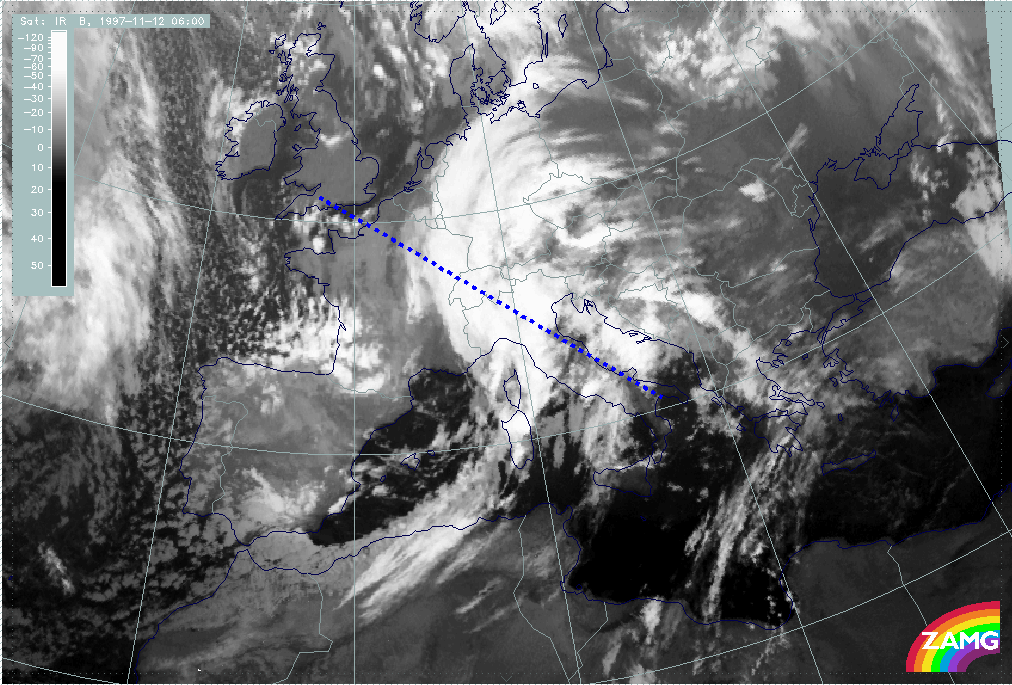
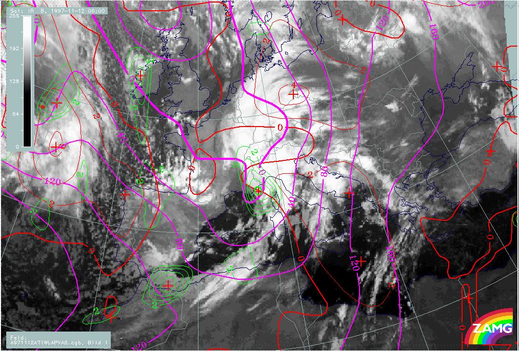
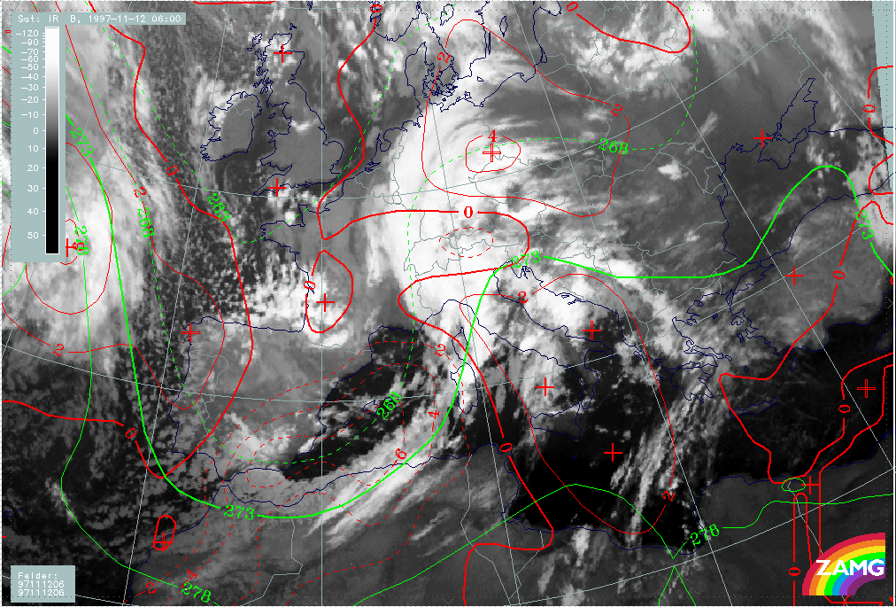
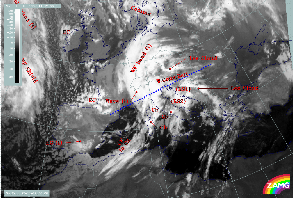
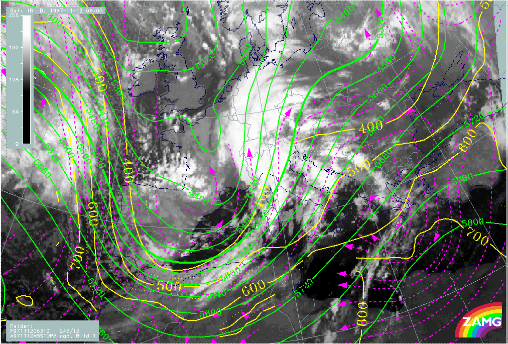
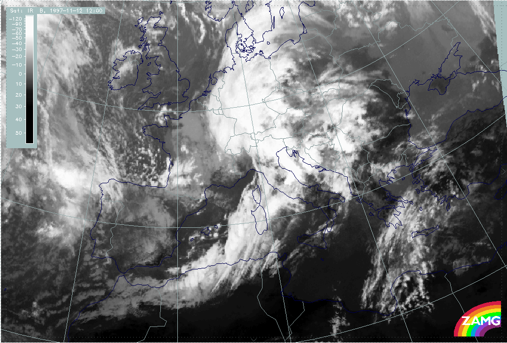
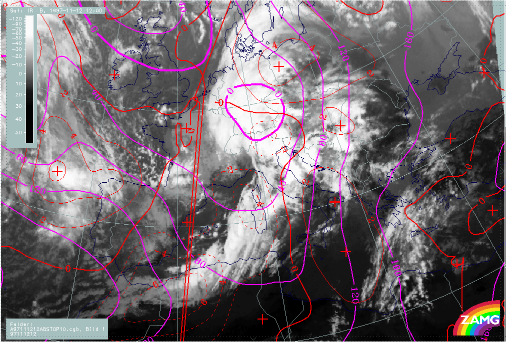
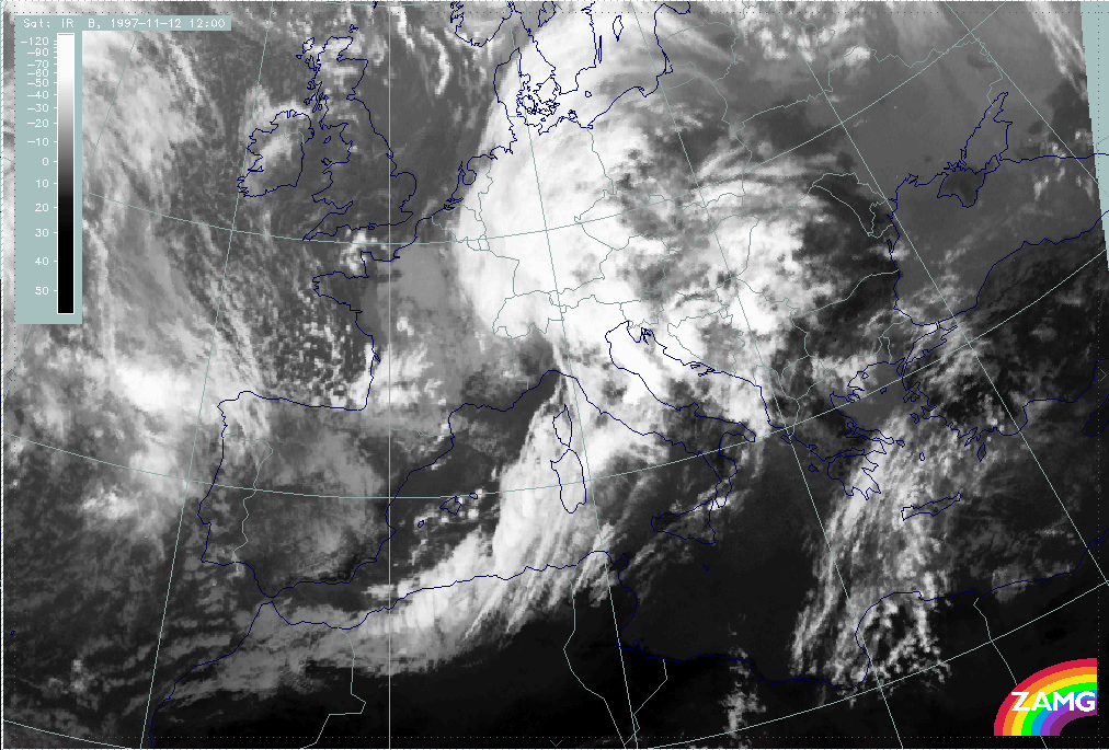
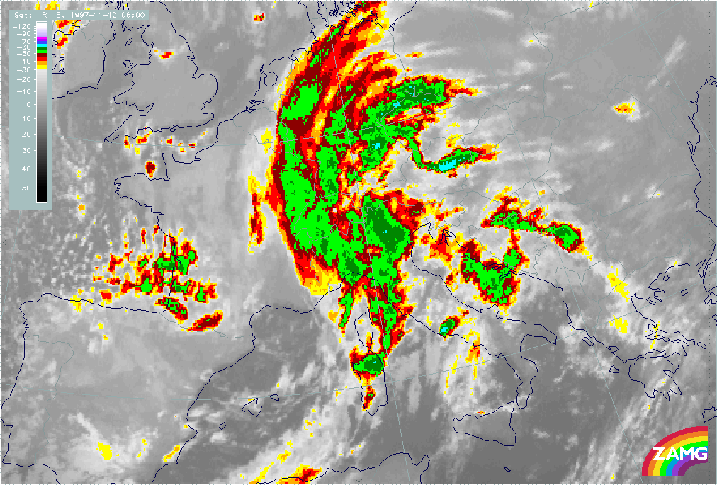
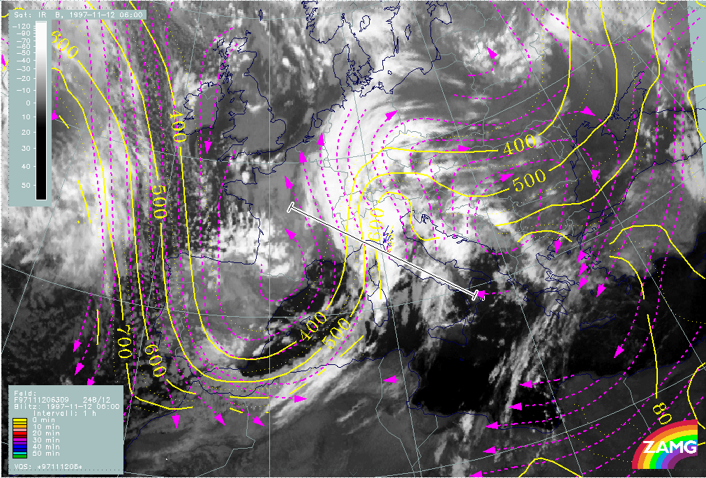
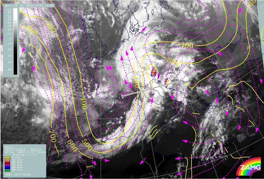
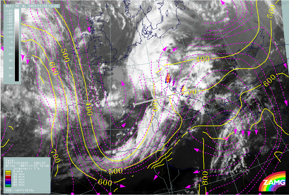
12 November 1997/06.00 UTC - Meteosat IR image; SatRep overlay: names of conceptual models
|
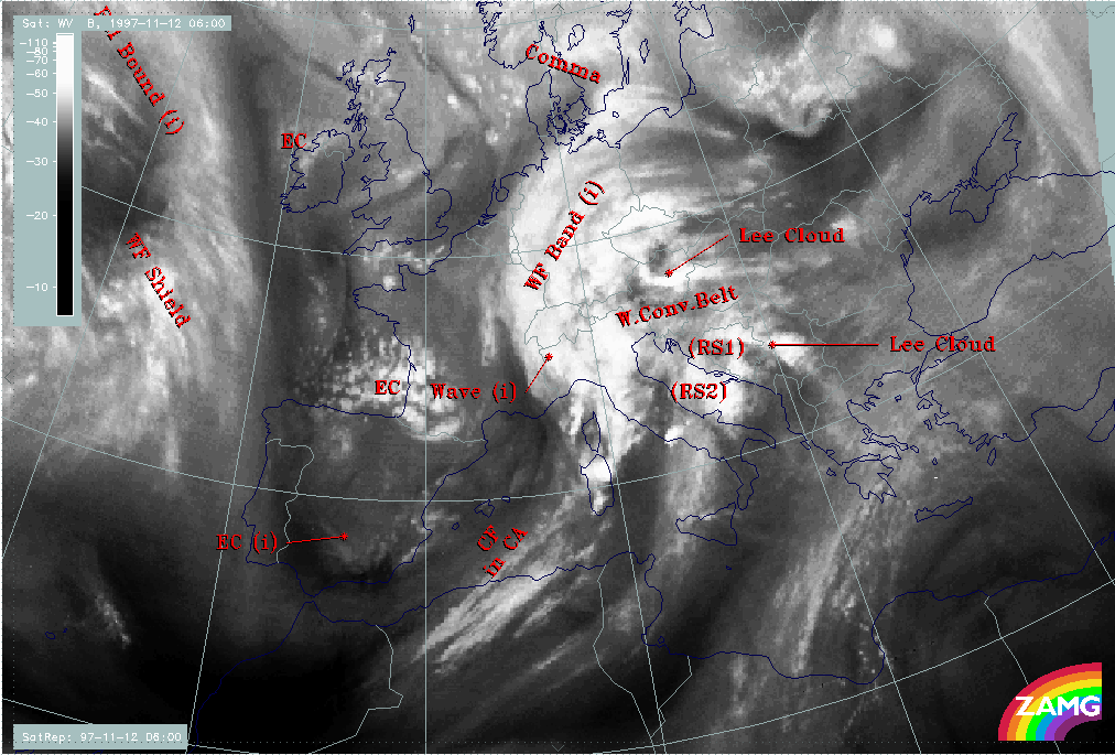
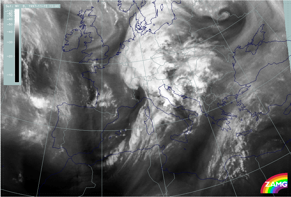
12 November 1997/06.00 UTC - Meteosat WV image; SatRep overlay: names of conceptual models
|
|
|
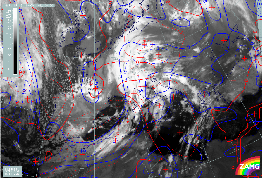
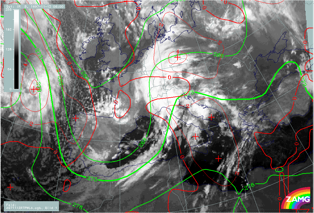
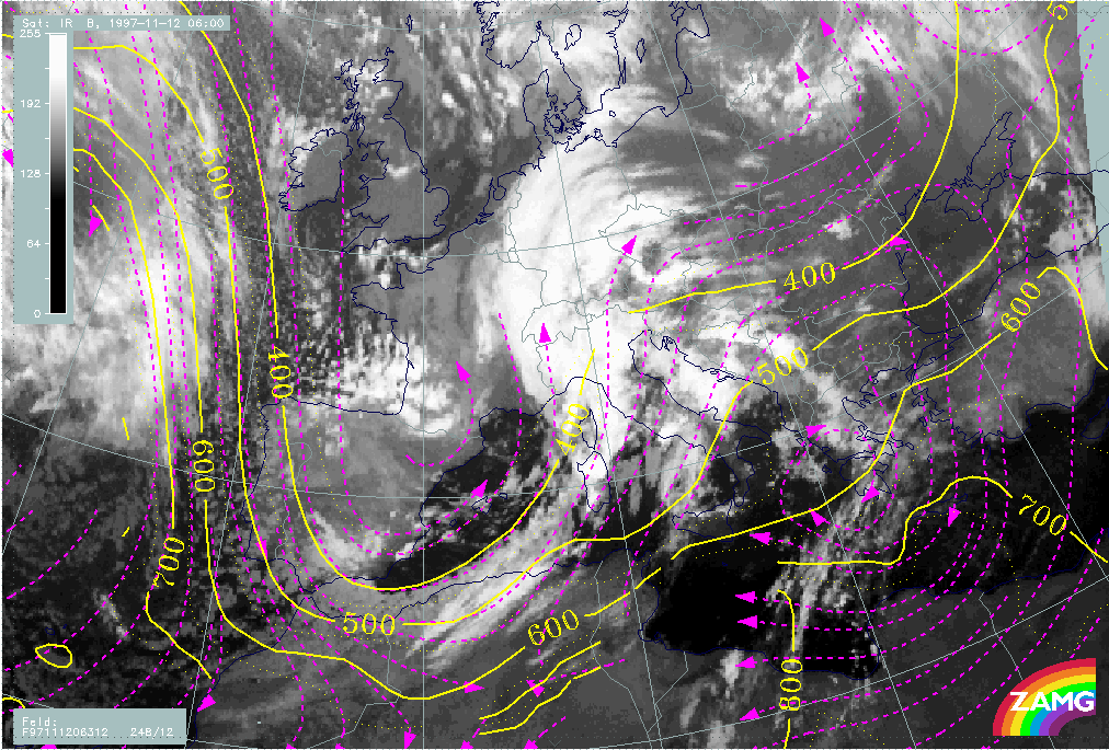
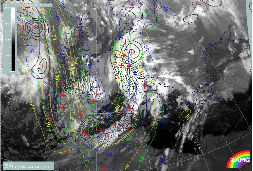
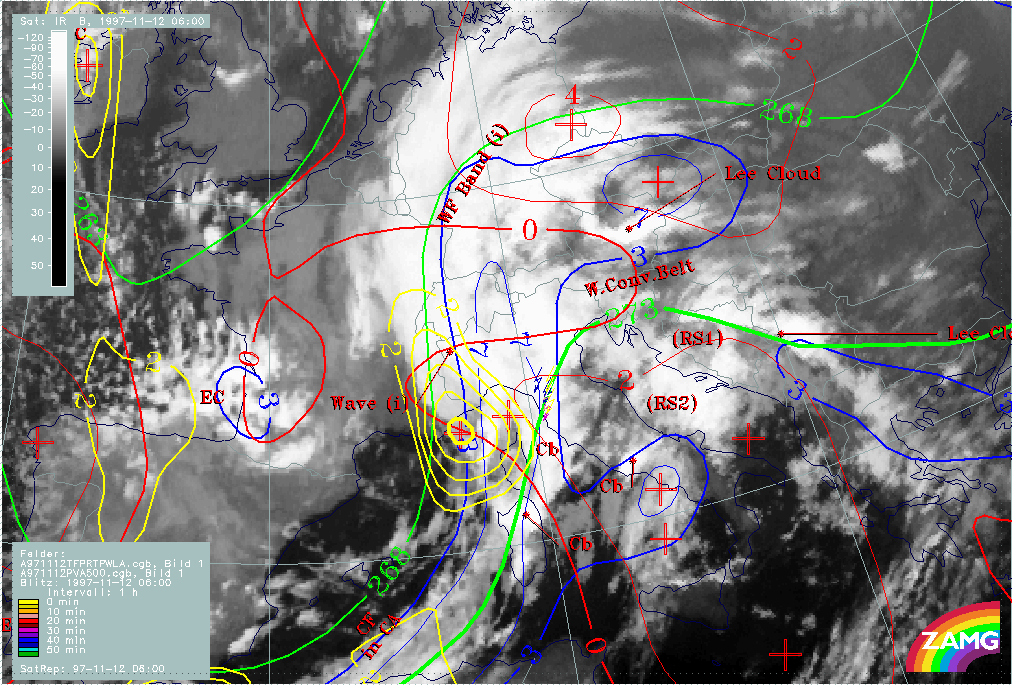
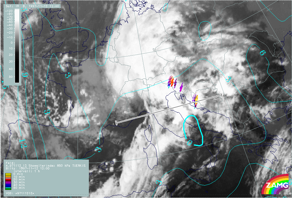
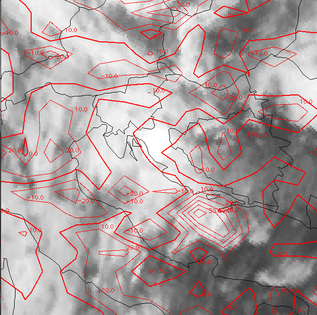
The IR (left image) and WV (right image) satellite images show a frontal cloud system in the centre of the image with a rather narrow Cold Front cloud band extending from Africa northward to Sardinia and Corsica. It is diagnosed as a Cold Front under CA (CF in CA). Over north Italy and the Alpine area a Wave can be identified accompanied by a typical huge cloud bulge; finally a Warm Front cloud band (WF band) extends from Switzerland across Germany to the east border of Poland. The Wave is the subject of a separate discussion (compare Wave development in the area Sardinia - Corsica).
Behind this frontal system two cold air features labelled with EC (Enhanced Cumuli) can be identified by increased cellular structure; in particular the southern one over south-east Spain will be mentioned in connection with the topic of the Front Intensification by Jet Crossing (JI) (compare Intensification of frontal cloudiness and activity by jet crossing).
In front of the frontal system quite different cloudiness appears: fibrous types interrupted or enhanced by orography and orographic cloudiness. Such a cloud configuration in this area can typically be found in the thickness ridge in front of fronts and will be discussed under the separate topic of relative streams in the chapter Cloudiness over Italy and the Balkan Peninsula in front of the Cold Front: Relative Streams.
The WV imagery gives additional information in three areas:
- There is black, i.e. very dry, air over Spain and also close to the southern EC cloudiness which consequently has much lower tops than the northern one
- There is another very black area at the rear side of the Wave in the Gulf du Lion
- There is a light grey WV band from Tunisia across middle Italy and the Adriatic Sea into the Balkan Peninsula
|
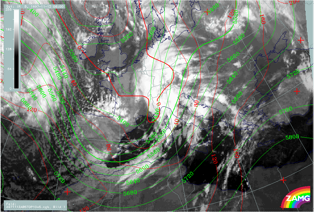
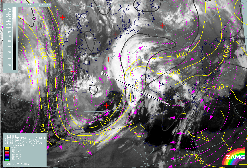
12 November 1997/06.00 UTC - Meteosat IR image; red: height contours 1000 hPa, green: height contours 500 hPa
|
|
|
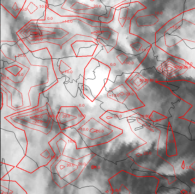
The image above shows the height distribution close to the surface (1000 hPa) and in the upper levels (500 hPa). At both heights notable troughs can be recognized which are backward inclined against each other. There is a broad surface minimum coinciding with the Wave area. The ECs are more to the rear of the upper level trough axis, indicating that jet streaks with shear vorticity have some important influence there. The cloudiness in front of the frontal system is within a broad south-western stream at upper levels.
|
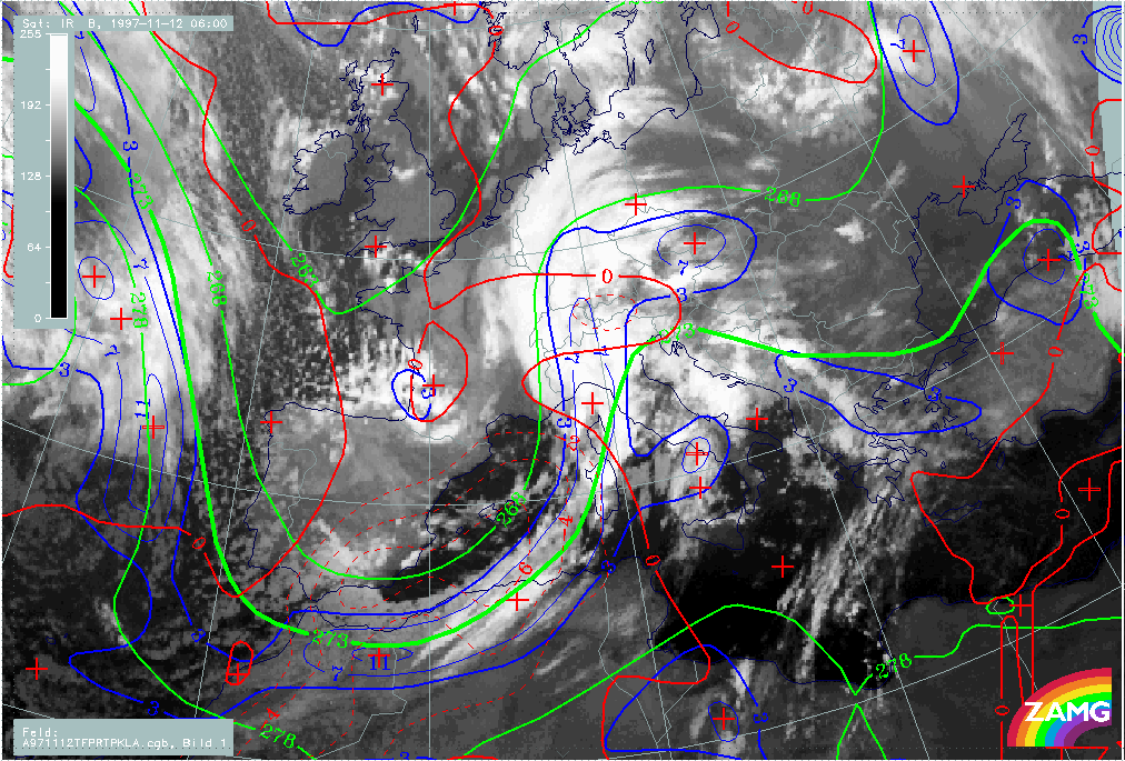
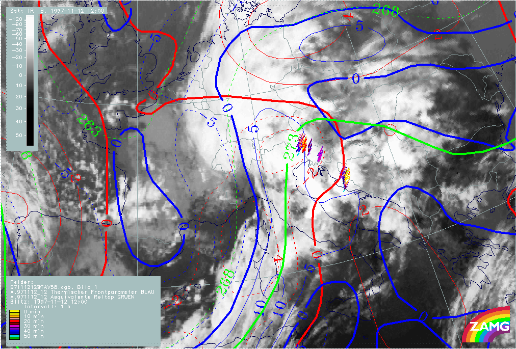
12 November 1997/06.00 UTC - Meteosat IR image; blue: thermal front parameter (TFP) 500/850 hPa, green: equivalent thickness 500/850
hPa, red: temperature advection - CA 1000 hPa
|
|
|
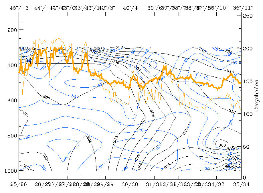
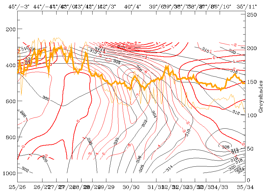
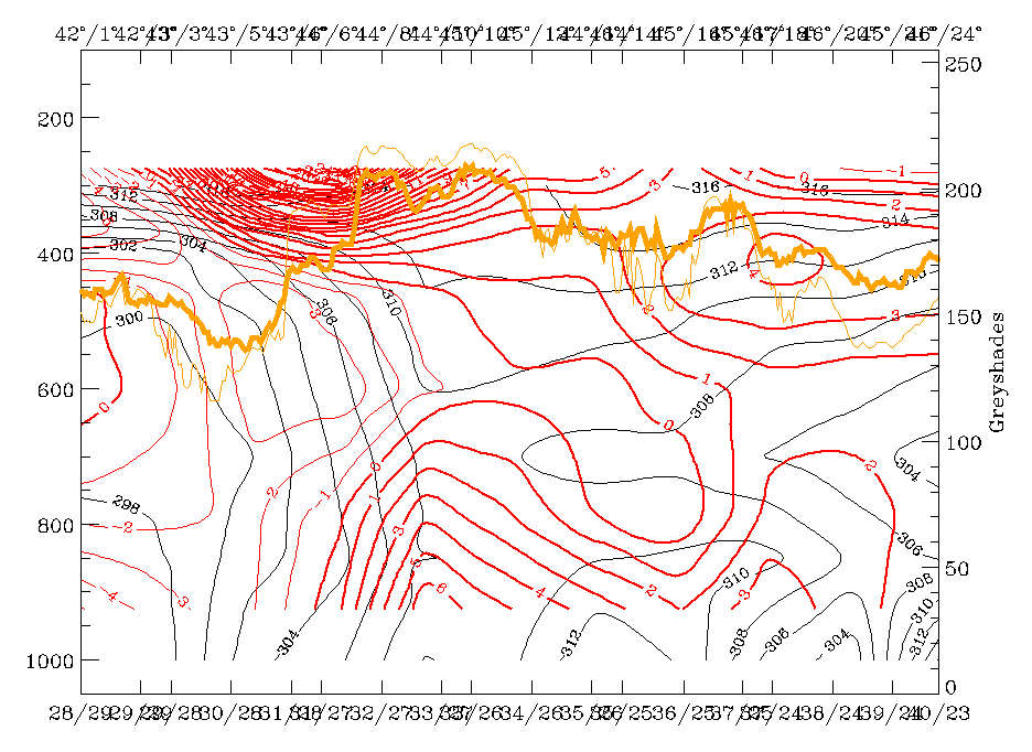
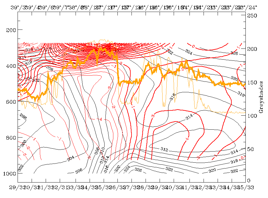
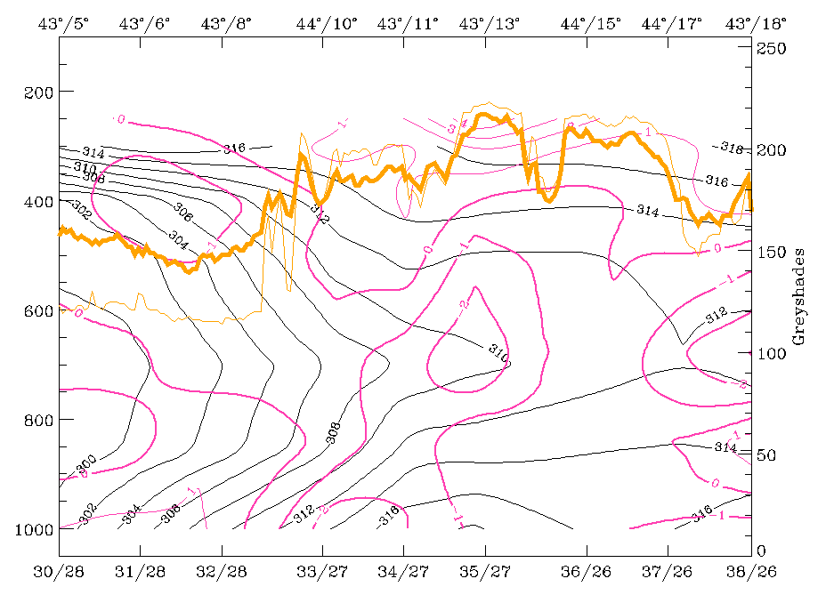
The Cold Front in Cold Advection (CF in CA) is accompanied by a thickness gradient and a thermal front parameter (TFP) which is close to the leading edge of the cloud band. Cold advection (CA) can be recognized already in front of the cloud band, but the largest gradient is within and the strongest CA behind the cloud band. These are conditions which are similar to a classical Cold Front (compare Conceptual Models: Cold Front and Conceptual Models: Cold Front in Cold Advection ).
|
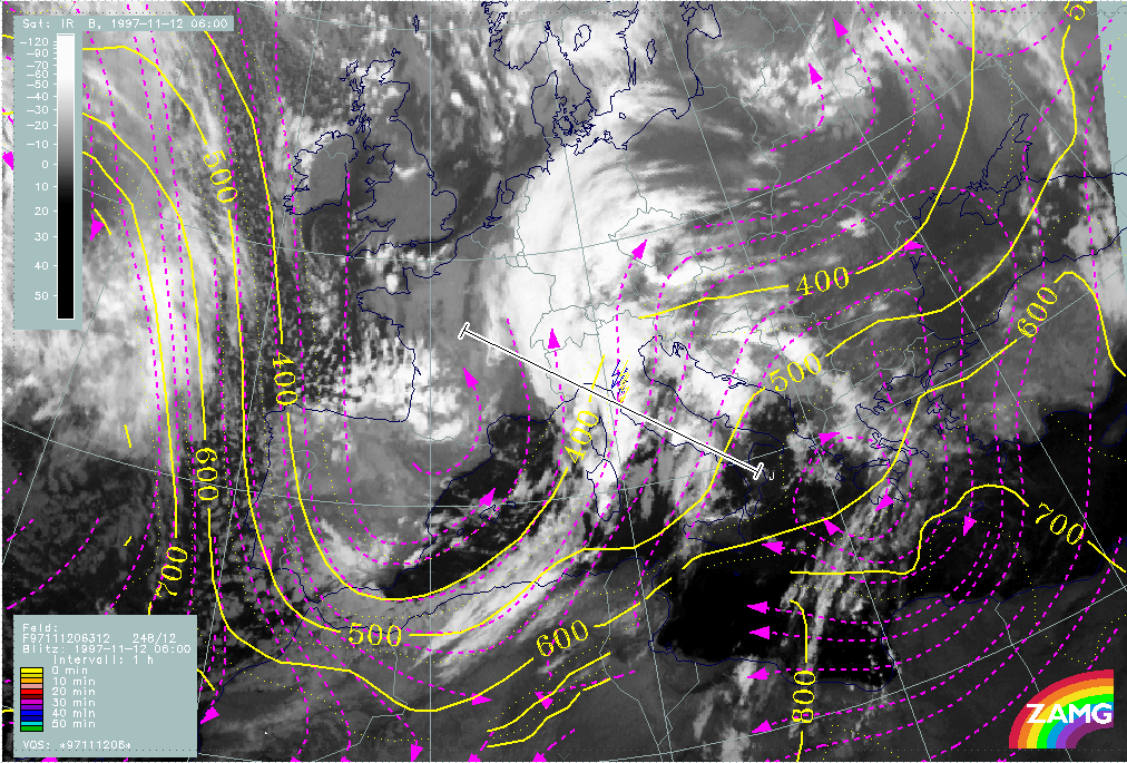
12 November 1997/06.00 UTC - Meteosat IR image; SatRep overlay: names of conceptual models; position of vertical cross section indicated
|
|

|
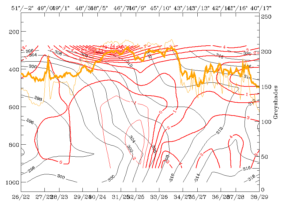
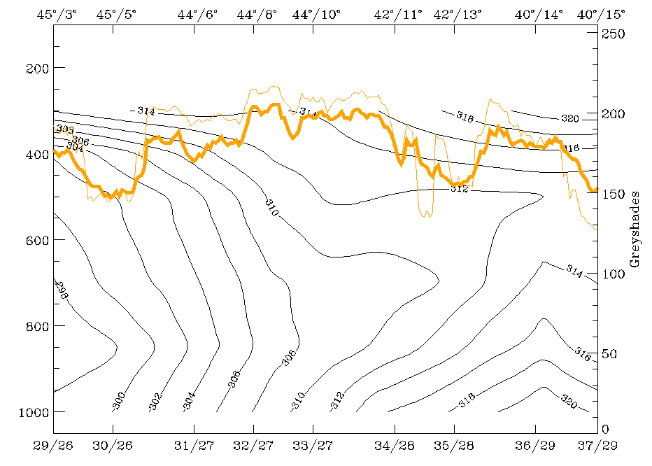
The vertical cross section G extending from the Bay of Biscay across the east Pyrenees and the Cold Front cloud band to Tunisia give more information about the structure of the Cold Front.
|
12 November 1997/06.00 UTC - Vertical cross section; black: isentropes (ThetaE), blue: relative humidity, orange thin: IR pixel values,
orange thick: WV pixel values
|
12 November 1997/06.00 UTC - Vertical cross section; black: isentropes (ThetaE), red thin: temperature advection - CA, red thick:
temperature advection - WA, orange thin: IR pixel values, orange thick: WV pixel values
|
|
|
|
|
|
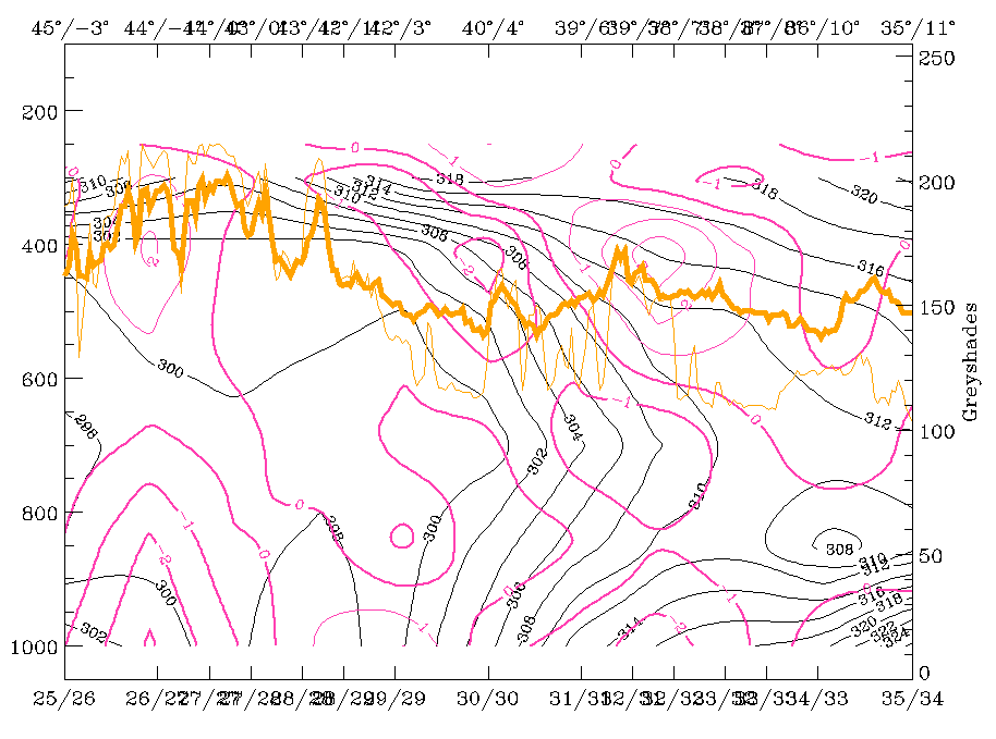
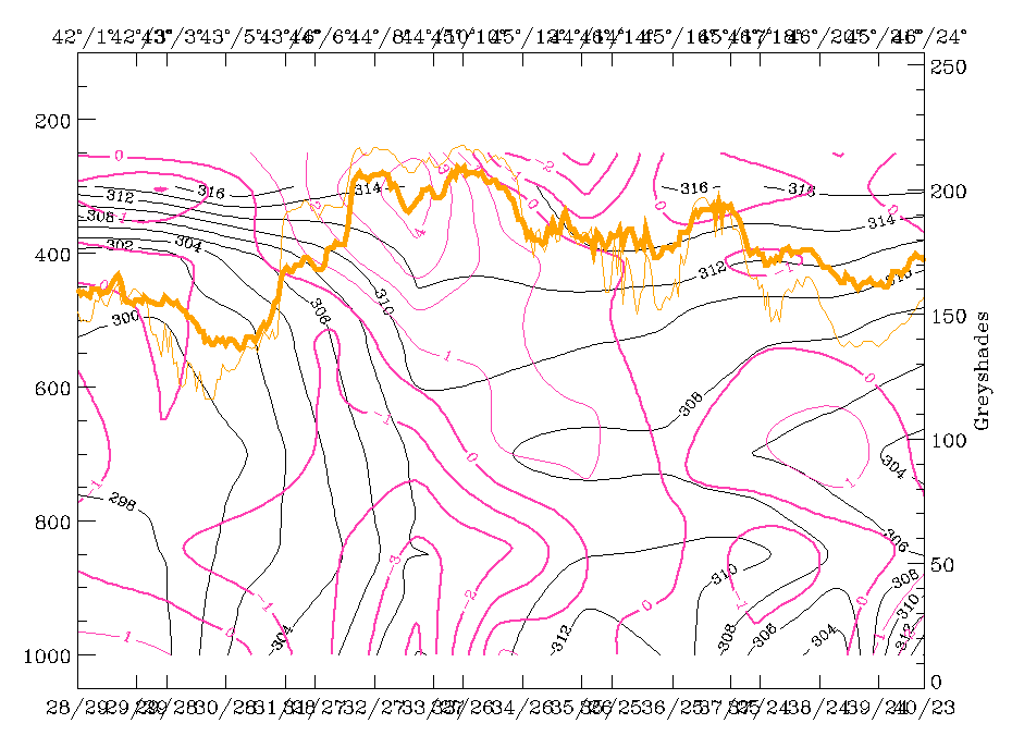
12 November 1997/06.00 UTC - Vertical cross section; black: isentropes (ThetaE), magenta thin: divergence, magenta thick: convergence,
orange thin: IR pixel values, orange thick: WV pixel values
|
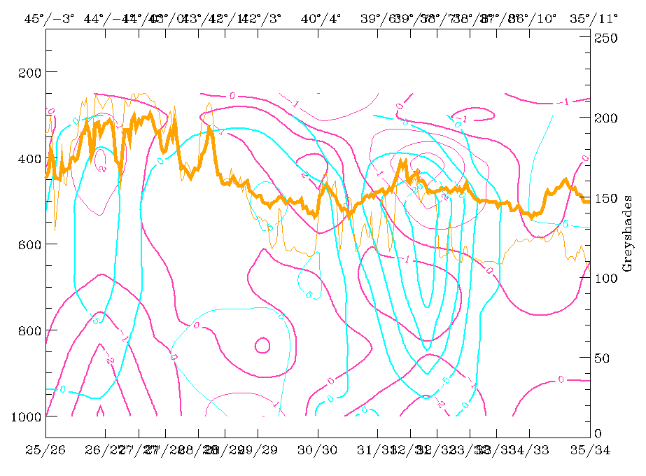
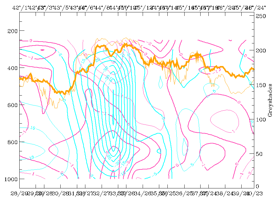
12 November 1997/06.00 UTC - Vertical cross section; black: isentropes (ThetaE), cyan thick: vertical motion (omega) - upward motion,
cyan thin: vertical motion (omega) - downward motion, magenta thin: divergence, magenta thick: convergence, orange thin: IR pixel
values, orange thick: WV pixel values
|
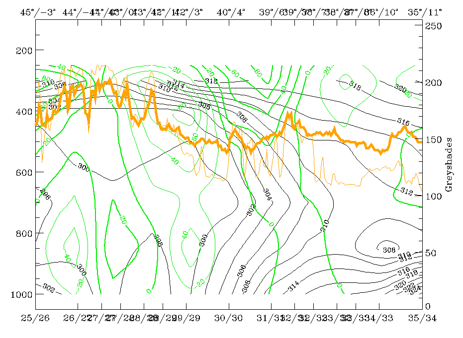
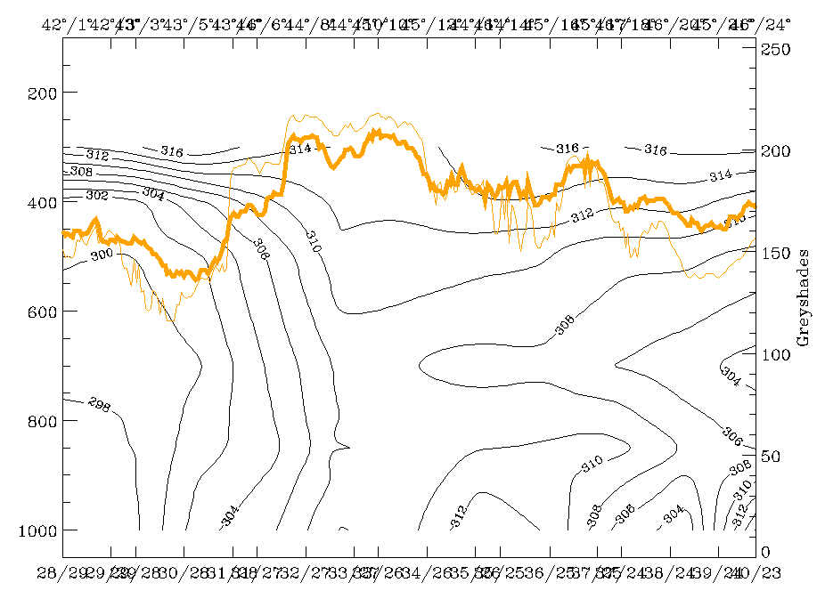
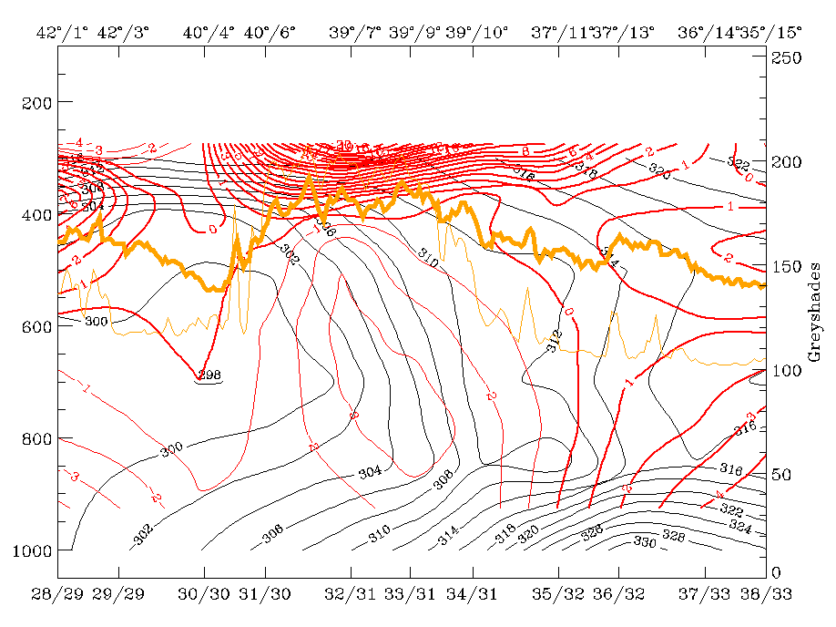
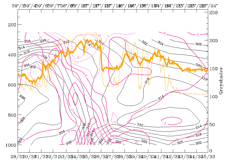
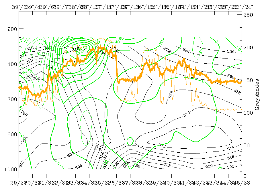
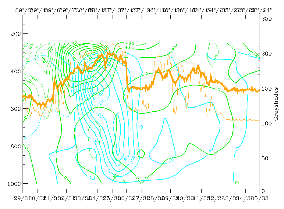
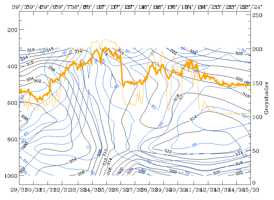
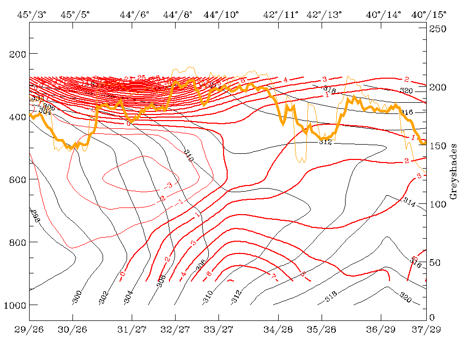
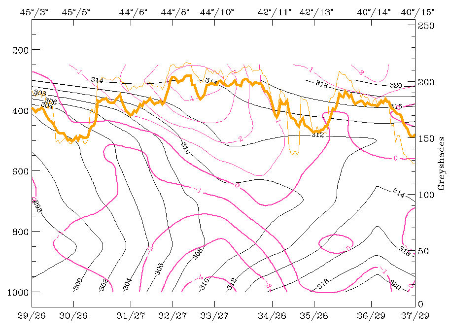
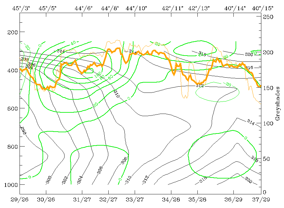
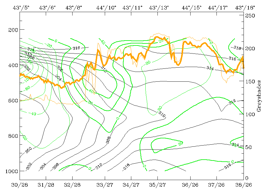
The westernmost peak in the IR and WV signals corresponds to the EC cloudiness over the Bay of Biscay, the peak around 39N/07E corresponds to the Cold Front. Isentropes (ThetaE) show a typical frontal surface inclined from 300 - 400 hPa over 42N/03E downward to approximately 750 - 800 hPa. Below this there is a more complicated boundary layer structure within the frontal surface which is superadiabatic as well as behind it. In particular the boundary layer in front with decreasing values of ThetaE represents a stationary warm air pillow. TA (right image top) supports the CA in front of the frontal cloud band but shows clearly that this is only in the lower troposphere up to about 700 - 650 hPa. Above this there is WA on top of the frontal surface, as usual for Cold Fronts. There is also considerable convergence (left image bottom) connected with the frontal surface leading to upward motion on top of it (right image bottom). That means that the circulation cell connected with the Cold Front is well developed.
|
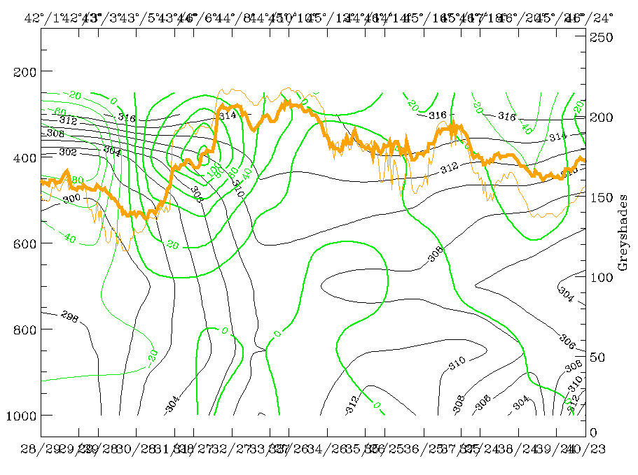
12 November 1997/06.00 UTC - Vertical cross section; black: isentropes (ThetaE), green thick: vorticity advection - PVA, green thin:
vorticity advection - NVA, orange thin: IR pixel values, orange thick: WV pixel values
|
12 November 1997/06.00 UTC - Vertical cross section; black: isentropes (ThetaE), lilac: Q-Vector (normal component), orange thin: IR
pixel values, orange thick: WV pixel values
|
|
|
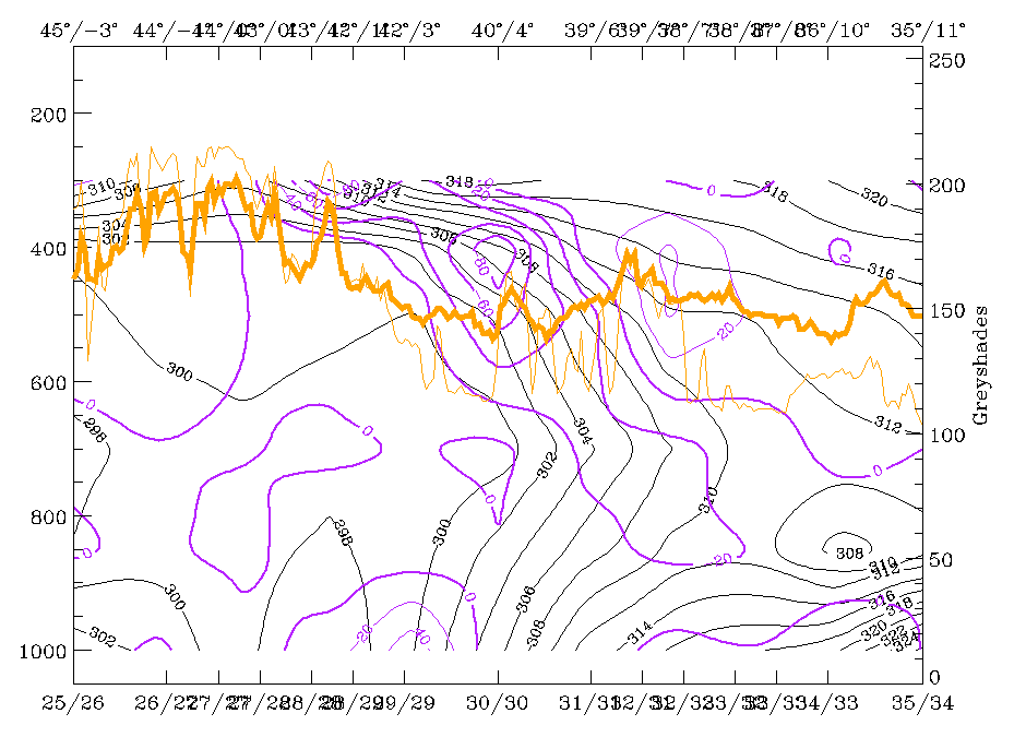
The most pronounced upward motion is in upper levels where there is some higher cloud close to the leading edge of the frontal cloud band. Increasing values of positive vorticity advection (PVA) (left image) are directly within the frontal crowding zone, while in the higher part above 650 hPa high values of the frontogenetic parameter (right image) indicate further frontogenesis. So summarizing, there is a well-developed Cold Front zone down to about 800 - 750 hPa indicating further strengthening but with a superadiabatic boundary layer below.
|
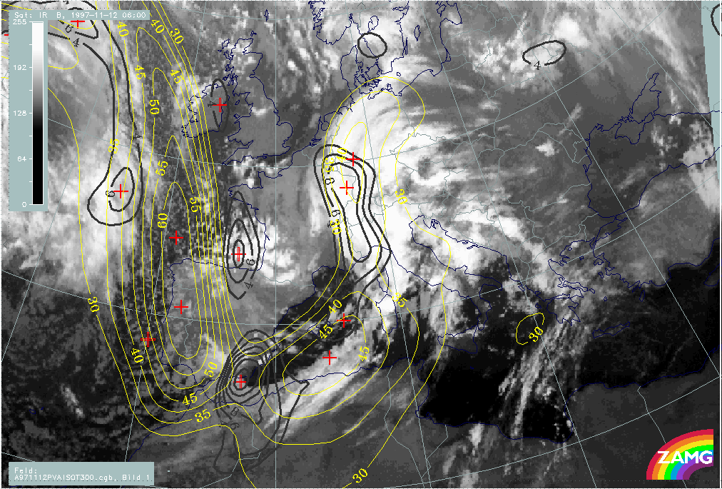
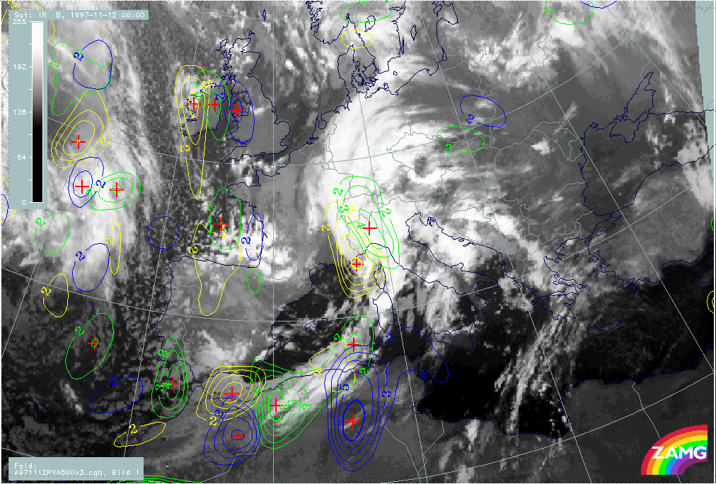
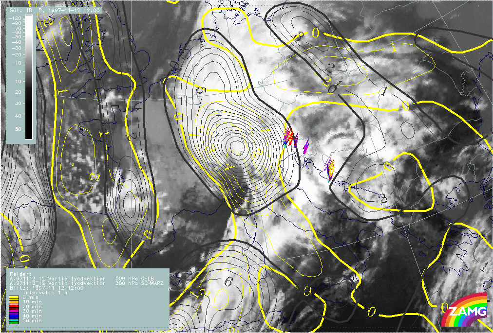
12 November 1997/06.00 UTC - Meteosat IR image; yellow: positive vorticity advection (PVA) 500 hPa
|
|
|
As PVA could be identified in the vertical cross section the image above shows the distribution of this parameter at 500 hPa. The most notable centres are connected with the Wave and close to the EC over Spain, respectively; both areas will be discussed separately in the following chapters (compare Wave development in the area Sardinia - Corsica and Intensification of frontal cloudiness and activity by jet streak crossing.
|
12 November 1997/06.00 UTC - Meteosat IR image; blue: thermal front parameter (TFP) 500/850 hPa, red: temperature advection 1000 hPa
|
|
|
The Warm Front (WF band) is of a cloud band type with a well-developed WA maximum in front of the TFP (right image). Notable is the intersection of CA over the Alpine area.
|
12 November 1997/06.00 UTC - Meteosat IR image; position of vertical cross section indicated
|
12 November 1997/06.00 UTC - Vertical cross section; black: isentropes (ThetaE), red thin: temperature advection - CA, red thick:
temperature advection - WA, orange thin: IR pixel values, orange thick: WV pixel values
|
|
|
A vertical cross section across this area shows that there is extremely intensive CA in the middle and low layer of the troposphere but WA above. The question about the origin of this CA arises, of course.
|
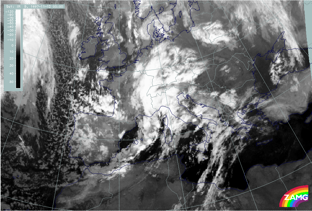
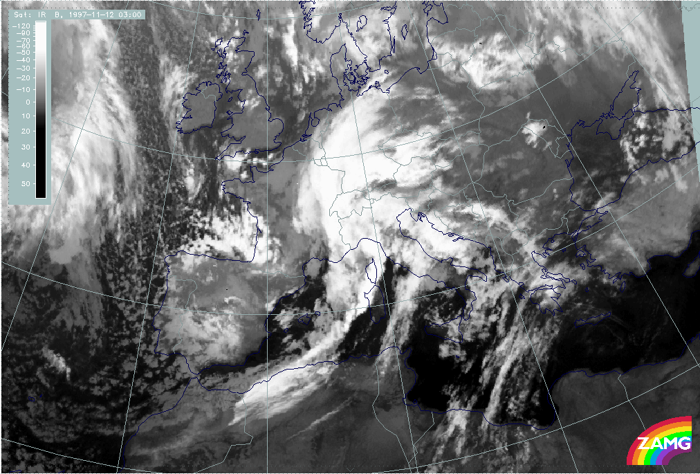
12 November 1997/00.00 UTC - Meteosat IR image
|
12 November 1997/03.00 UTC - Meteosat IR image
|
|
|
Images of 00.00 (left image) and 03.00 UTC (right image) of the same day show that approximately six hours earlier a Wave development took place over France; the appearance in the images is very similar to a cold conveyor belt development with a low cloud spiral emerging from below. CA could be the remains of this Wave development while at 06.00 UTC the southern Wave development dominates.
Wave development in the area Sardinia - Corsica
|
12 November 1997/06.00 UTC - Meteosat IR image; magenta: height contours 1000 hPa, red: temperature advection - WA 1000 hPa, green:
positive vorticty advection (PVA) 500 hPa
|
|
|
In the image above three parameters relevant for Wave development are combined: height of 1000 hPa, WA and PVA at 500 hPa. In the case of a well-developed Wave a surface minimum, a WA maximum within the cloud bulge and a PVA maximum are signs for an ongoing deepening of pressure and an intensification of the cyclonic circulation. There is an excellent coincidence between the cloud bulge and these parameter features. The only deviating feature is the CA zone north of the Wave point over Switzerland and Austria which has already been discussed before in connection with the Warm Front (compare Overview and frontal diagnosis).
|
12 November 1997/06.00 UTC - Meteosat IR image; red: height of PV = 2 units
|
|
|
Another interesting parameter in connection with waves is potential vorticity (PV). The image above shows the height of the PV = 2 units surface which is an indication for the height of the tropopause there and separates tropospheric from dry stratospheric air. In the case of a classical Wave development PV = 2 units only extend down to approximately 300 hPa which is confirmed also in this study.
|
12 November 1997/06.00 UTC - Meteosat IR image; SatRep overlay: names of conceptual models; position of vertical cross section indicated
|
|
|
From the vertical cross section, which extends from the Pyrenees across north Italy and Croatia to Romania, additional information about the vertical structure of the troposphere in the area of the Wave can be gained.
|
12 November 1997/06.00 UTC - Vertical cross section; black: isentropes (ThetaE), blue: relative humidity, orange thin: IR pixel values,
orange thick: WV pixel values
|
12 November 1997/06.00 UTC - Vertical cross section; black: isentropes (ThetaE), red thin: temperature advection - CA, red thick:
temperature advection - WA, orange thin: IR pixel values, orange thick: WV pixel values
|
|
|
|
|
|
12 November 1997/06.00 UTC - Vertical cross section; black: isentropes (ThetaE), magenta thin: divergence, magenta thick: convergence,
orange thin: IR pixel values, orange thick: WV pixel values
|
12 November 1997/06.00 UTC - Vertical cross section; black: isentropes (ThetaE), cyan thick: vertical motion (omega) - upward motion,
cyan thin: vertical motion (omega) - downward motion, magenta thin: divergence, magenta thick: convergence, orange thin: IR pixel
values, orange thick: WV pixel values
|
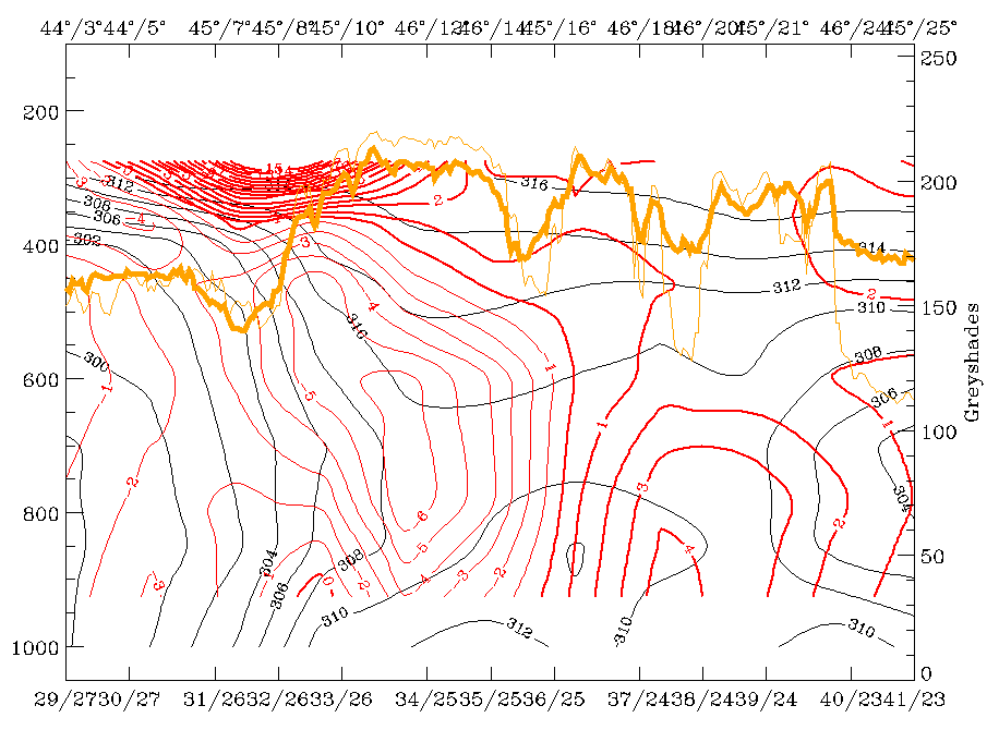
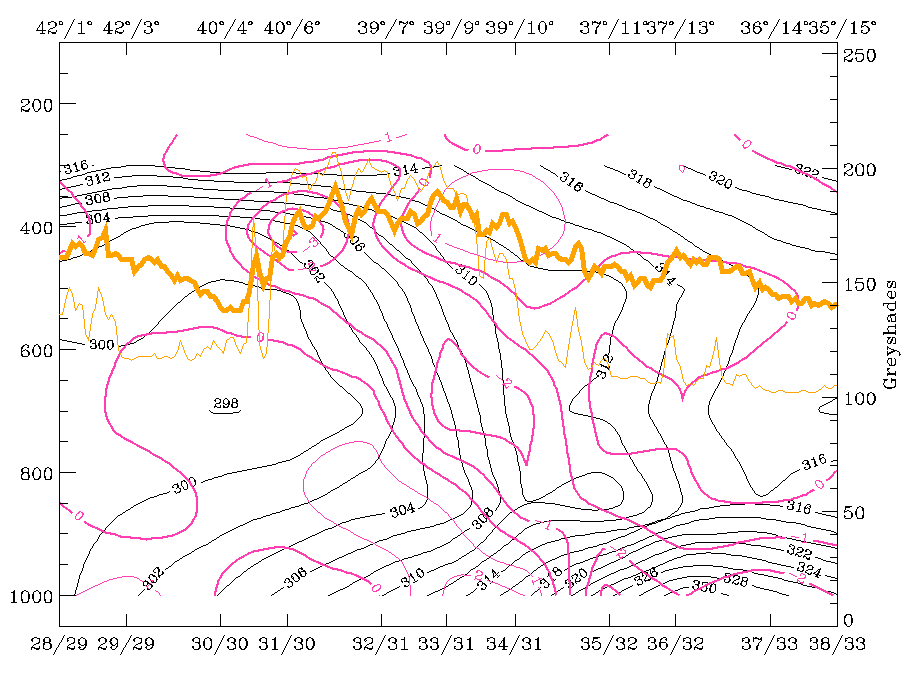
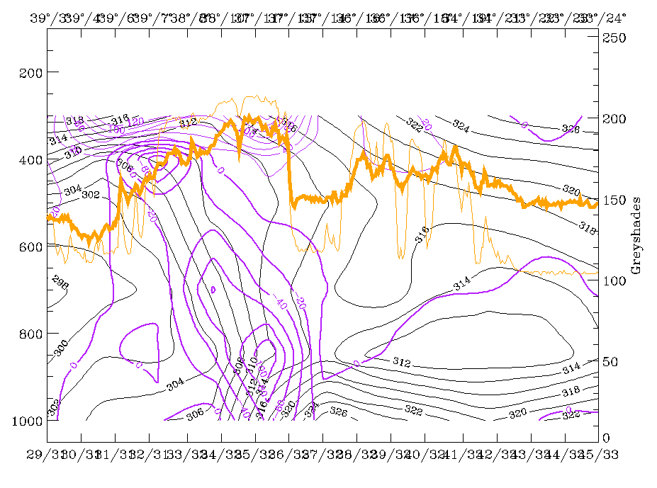
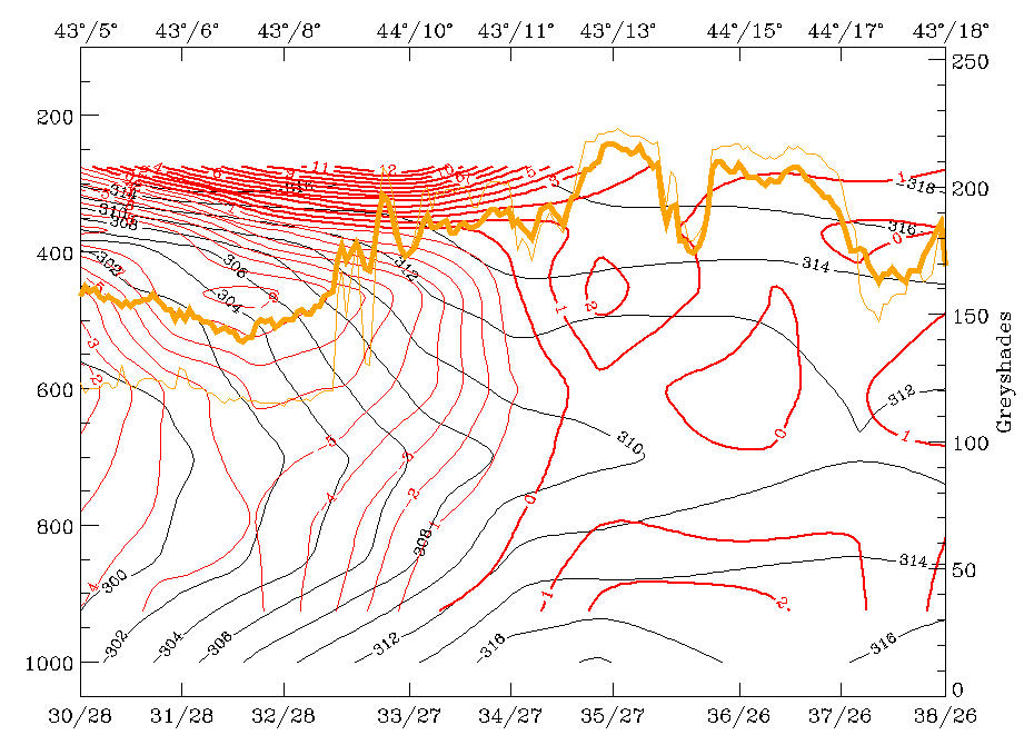
The main IR and WV peaks between 44N/08E and 45N/10E correspond to the frontal wave cloudiness, the eastern peak at about 45N/16E represents high lee cloudiness at the Dinaric Alps. Isentropes form a very steep crowding zone from 400 hPa down to the surface over north-west Italy. A tongue of wet air is back-bent on top of the frontal surface and reaches up to 300 hPa.
|
12 November 1997/06.00 UTC - Vertical cross section; black: isentropes (ThetaE), green thick: vorticity advection - PVA, green thin:
vorticity advection - NVA, orange thin: IR pixel values, orange thick: WV pixel values
|
12 November 1997/06.00 UTC - Vertical cross section; black: isentropes (ThetaE), lilac: Q-Vector (normal component), orange thin: IR
pixel values, orange thick: WV pixel values
|
|
|
WA in front and on top of, as well as PVA on top of the frontal surface, are both well developed in the Wave area. Convergence has, especially in the lower layers, well-pronounced values. Both convergence and PVA are the reason for very strong upward motion on top of the frontal surface. In contrast to the southern vertical cross section (compare Overview and frontal diagnosis) which showed frontogenesis in the middle and upper layers, the negative n-component of the Q-vector is rather weak in this area of the front.
Intensification of frontal cloudiness and activity by jet streak crossing
|
12 November 1997/06.00 UTC - Meteosat IR image; green: equivalent thickness 500/850 hPa, red: temperature advection 1000 hPa
|
|
|
In the chapter Overview and frontal diagnosis two EC areas have already been mentioned. Both are situated within a thickness trough and the southern one at least is under the influence of CA (image above). In the actual SatRep of this day based on ECMWF forecast fields there was information that this EC is in the left exit region of a jet streak with only weak PVA and that the height with PV = 2 units is down to 450 hPa; this area should be observed!. Analysis fields used for this case study support this diagnosis strongly.
|
12 November 1997/06.00 UTC - Meteosat IR image; black: positive vorticity advection (PVA) 300 hPa, yellow: isotachs 300 hPa
|
|
|
The image above shows a notable jet streak from south Ireland to south Spain with a PVA maximum at 300 hPa superimposed on the low part of the Cold Front in Cold Advection in an area south-east of Spain. The EC is more to the rear of this PVA maximum. Such a situation may be characteristic of the increase of frontal cloudiness and activity through the contribution of PVA to upward motion: Front intensification (compare Conceptual Models: Front Intensification by Jet Crossing ).
Indeed, such a development takes place in this case and will be demonstrated in Front Intensification by Jet Crossing.
Cloudiness over Italy and the Balkan peninsula in front of the Cold Front: Relative Streams
|
12 November 1997/06.00 UTC - Meteosat IR image; green: equivalent thickness 500/850 hPa, red: temperature advection - WA 1000 hPa
|
|
|
The cloudiness in front of the frontal system has a fibrous character and shows orographic modified cloudiness superimposed. As can be seen from the image above there is a thickness ridge and a big area of WA. Such a cloud configuration is very typical for the rising branches of a Warm Conveyor Belt - a diagnosis which can also be expected from the location in front of the Cold Front (compare Conceptual Models: Warm Conveyor Belt ).
|
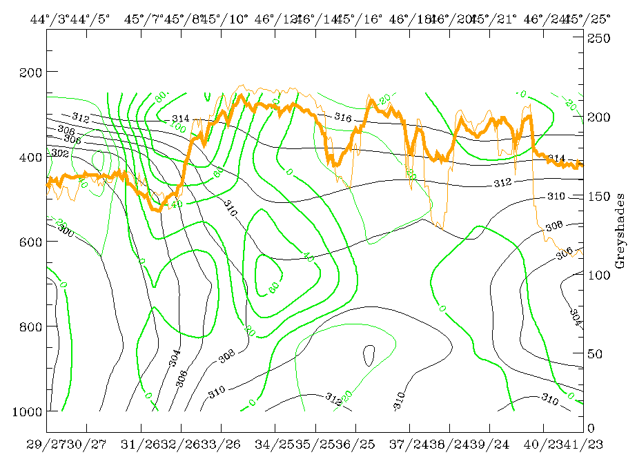
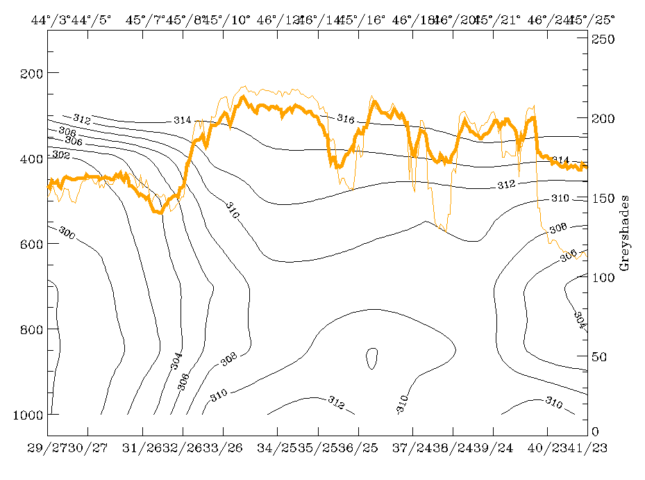
12 November 1997/06.00 UTC - Meteosat IR image; SatRep overlay: names of conceptual models; position of vertical cross section indicated
|
12 November 1997/06.00 UTC - Vertical cross section; black: isentropes (ThetaE), orange thin: IR pixel values, orange thick: WV pixel
values
|
|
|
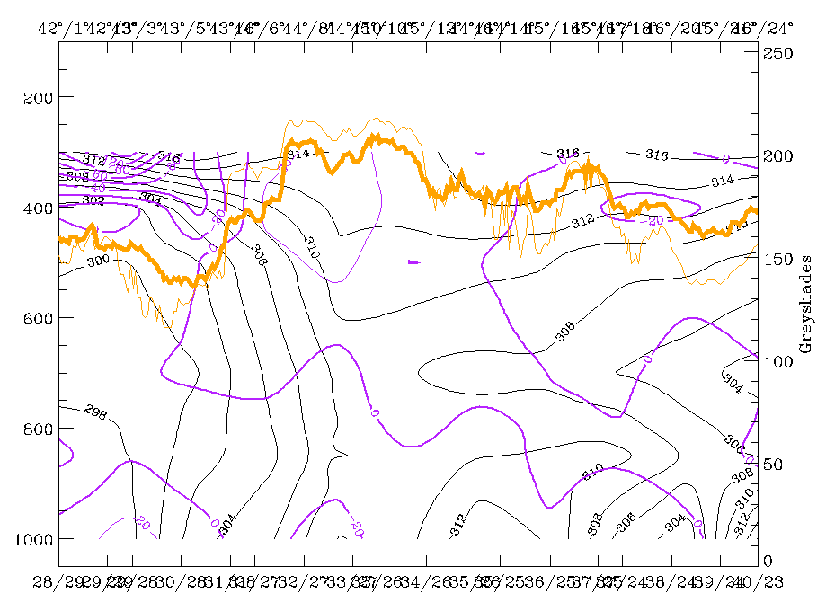
For the characterisation of the Warm Conveyor Belt, relative streams on relevant isentropes are most indicative. The right image above gives an overview over the selected surfaces: 308K is a surface on top of the Cold Front which can be investigated down to about 700 hPa while 312K is a high surface between 300 and 450 hPa.
|
12 November 1997/06.00 UTC - Meteosat WV image; black: shear vorticity 300 hPa, magenta: relative streams 308K - system velocity
248° 12 m/s, yellow: isotachs
|
|
|
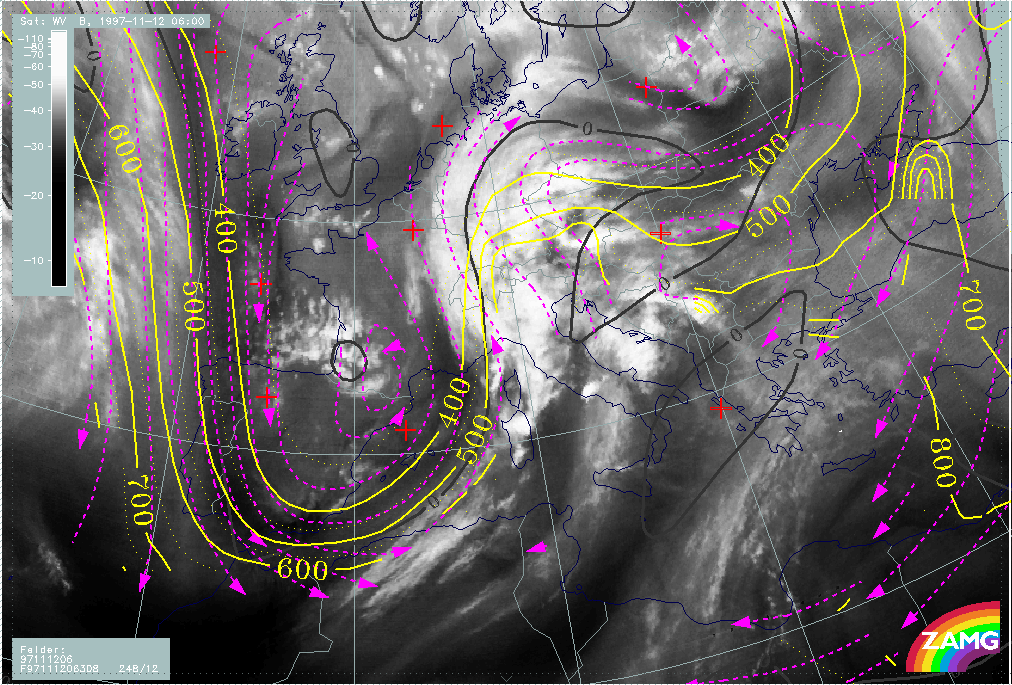
On the 308K surface the relative streams involved in the Cold Front in Cold Advection and in the Warm Front Band can be seen very well. There are relative streams over the Atlantic from north to south turning to northern directions again south of Spain. In relation to the Cold Front one can discriminate the wet relative stream from north-west which is on the anticyclonic side of the jet axis (zero line of shear vorticity in black) and the dry intrusion which is on the cyclonic side of the jet axis. The first relative stream is parallel to the cloud band of the Cold Front without any distinct vertical motion but rising in the area of the cloud bulge north of the Wave point. The relative stream lines of the dry intrusion can be found at the rear side of the cloud band and accompany the black area in the WV imagery. Over Croatia, Slovenia, Austria and the Warm Front cloud band a rising relative stream can be recognized which represents on this surface the Warm Conveyor Belt. This situation is a very classical one for a Cold Front and a Warm Front.
|
12 November 1997/06.00 UTC - Meteosat IR image; black: shear vorticity 300 hPa, magenta: relative streams 312K - system velocity
248° 12 m/s, yellow: isotachs
|
12 November 1997/06.00 UTC - Meteosat IR image; green: height contours 500 hPa, magenta: relative streams 312K - system velocity
248° 12 m/s, yellow: isotachs
|
|
|
On the higher isentropic surface of 312K (left image) a very distinct Warm Conveyor Belt can be seen with stream lines rising between 700 - 600 and 400 hPa from Tunisia across Italy, the Adriatic Sea and the Balkan Peninsula. The lines are in front of the Cold Front cloud band and parallel to several cloud lines and cloud features in front of the frontal system. The sinking branch of the Warm Conveyor Belt can be observed east of about 25E. By comparing the absolute stream lines at 500 hPa and the relative ones on the 312K surface (right image) the additional information of relative streams can be seen; although there is a south-west - north-east stream in both fields over Italy and the Balkan Peninsula, air masses of different origins are involved which merge at the leading edge ofthe Cold Front cloud band.
|
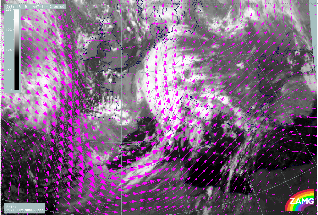
12 November 1997/06.00 UTC - Meteosat WV image; magenta: wind vectors 500 hPa
|
|
|
In such cases very often orographic lee cloudiness is superimposed. This can be seen best in the lee of the mountains from Croatia, Bosnia and Yugoslavia as well as in the lee of the Alps in north-east Austria. In the image above the wind vectors clearly show the normal orientation to the mountain ranges. One can conclude from this that the combination of both the overall rising on the inclined isentropic surfaces taking place in the Warm Conveyor Belt and the rising in the lee waves of mountains is responsible for condensation and cloud development there.
Frontal displacement with help of the Thermal Front Parameter
|
12 November 1997/06.00 UTC - Meteosat IR image; yellow: thermal front parameter (TFP) 500/850 hPa 06.00 UTC, green: thermal front
parameter (TFP) 500/850 hPa 12.00 UTC, blue: thermal front parameter (TFP) 500/850 hPa 18.00 UTC
|
|
|
During the next 12 hours until 18.00 UTC the TFP shows a distinct eastward displacement for the cold front and a northward displacement of the Warm Front Band. At 18.00 UTC the TFP of the Cold Front reaches the eastern parts of Slovenia and Croatia and crosses central Austria. As the TFP for 06.00 UTC is close to the leading edge of the Cold Front band, most of Slovenia and Croatia and the eastern part of Austria remain mainly in the thickness ridge during the next 12 hours.
|
12 November 1997/12.00 UTC - Meteosat IR image; yellow: thermal front parameter (TFP) 500/850 hPa 06.00 UTC, green: thermal front
parameter (TFP) 500/850 hPa 12.00 UTC, blue: thermal front parameter (TFP) 500/850 hPa 18.00 UTC
|
12 November 1997/18.00 UTC - Meteosat IR image; yellow: thermal front parameter (TFP) 500/850 hPa 06.00 UTC, green: thermal front
parameter (TFP) 500/850 hPa 12.00 UTC, blue: thermal front parameter (TFP) 500/850 hPa 18.00 UTC
|
|
|
The images above showing the cloud systems at 12.00 and 18.00 UTC confirm the last conclusion; except for several intensifications the TFP remains on the frontal side of the Cold Front cloudiness for both points of time.
Displacement of the Wave
|
12 November 1997/06.00 UTC - Meteosat IR image; yellow: height contours 1000 hPa 06.00 UTC, green: height contours 1000 hPa 12.00 UTC,
blue: height contours 1000 hPa 18.00 UTC
|
12 November 1997/06.00 UTC - Meteosat IR image; yellow: positive vorticity advection (PVA) 500 hPa 06.00 UTC, green: positive vorticity
advection (PVA) 500 hPa 12.00 UTC, blue: positive vorticity advection (PVA) 500 hPa 18.00 UTC
|
|
|
For the Wave several relevant parameters can be inspected. The minimum of the isobaric height close to the surface (1000 hPa, left image) shows a quick displacement to the north-east across Germany to the Czech Republic; but it has to be recognised that there is also a very large low pressure area for instance over north Italy, Switzerland and west Austria. Another parameter useful to follow is PVA at 500 hPa. The right image shows also a north-eastward shift to north-west Italy until 12.00 UTC but a decay to less than 2 units at 18.00 UTC. Comparing with the surface pressure low, the propagation of the PVA maximum until 12.00 UTC is much slower.
|
12 November 1997/12.00 UTC - Meteosat IR image; yellow: height contours 1000 hPa 06.00 UTC, green: height contours 1000 hPa 12.00 UTC,
blue: height contours 1000 hPa 18.00 UTC
|
12 November 1997/18.00 UTC - Meteosat IR image; yellow: height contours 1000 hPa 06.00 UTC, green: height contours 1000 hPa 12.00 UTC,
blue: height contours 1000 hPa 18.00 UTC
|
|
|
The 12.00 UTC image (left image) has to be compared with the green lines, and it is noticeable that the centre of the spiral over north-west Italy is in the large area of the low pressure trough but not centred at the minimum which is over Germany. The same is true for 18.00 UTC (right image): the spiral over Switzerland is even more displaced from the pressure minimum over the Czech Republic. As the coincidence with the upper level trough (not shown here) is much better, one conclusion could be that the upper level features have a much bigger influence on the cloud configuration.
|
12 November 1997/06.00 UTC - Meteosat IR image; green: height contours 500 hPa, yellow: positive vorticity advection (PVA) 500 hPa
|
|

|
The image above clearly shows a small scale upper level trough immediately on the rear side of the cloud spiral and a PVA maximum superimposed on it. This will be discussed again in the chapters for the relevant points of time.
Front Intensification by Jet Crossing
|
12 November 1997/06.00 UTC - Meteosat IR image; yellow: isotachs 300 hPa 06.00 UTC, green: height contours 1000 hPa 12.00 UTC, blue:
height contours 1000 hPa 18.00 UTC, black solid: positive vorticity advection (PVA) 300 hPa 06.00 UTC, black dashed: positive vorticity
advection (PVA) 300 hPa 12.00 UTC, black solid: positive vorticity advection (PVA) 300 hPa 18.00 UTC
|
|
|
The image above shows the propagation of the jet streak and the related PVA maximum in the left exit region in 300 hPa. The jet streak itself moves from Portugal to the Spanish east coast while the PVA maximum can be followed along the African coast to Tunisia at 18.00 UTC. This has rather dramatic consequences for the frontal cloud band.
|
12 November 1997/12.00 UTC - Meteosat IR image; yellow: positive vorticity advection (PVA) 300 hPa 06.00 UTC, green: positive vorticity
advection (PVA) 300 hPa 12.00 UTC, blue: positive vorticity advection (PVA) 300 hPa 18.00 UTC
|
12 November 1997/18.00 UTC - Meteosat IR image; yellow: positive vorticity advection (PVA) 500 hPa 06.00 UTC, green: positive vorticity
advection (PVA) 500 hPa 12.00 UTC, blue: positive vorticity advection (PVA) 500 hPa 18.00 UTC
|
|
|
In the left image the white cellular cloudiness developed in the centre of the PVA maximum at the Algerian coast, and six hours later (right image) a Wave - like bulge has developed between the African coast and Sardinia, to where the PVA has moved.
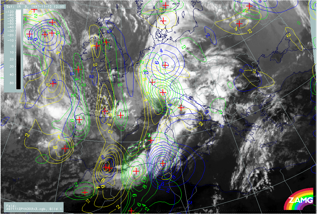
Overview and new aspects
Thunderstorms and their synoptic environment are discussed in a separate chapter (compare Development of Thunderstorms and MCSs During the Whole Period).
|
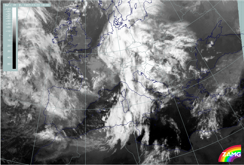
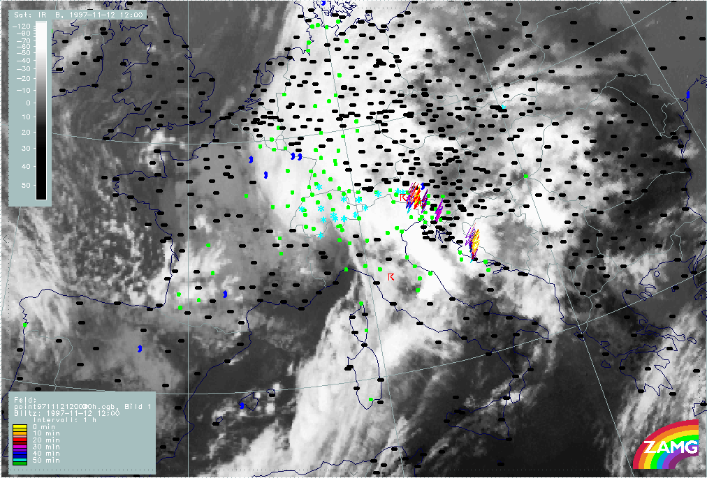
12 November 1997/12.00 UTC - Meteosat IR image
|
|
|
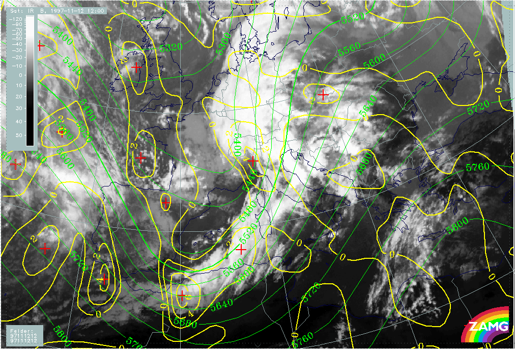
In the IR image of 12.00 UTC the most pronounced features are:
- The further development of the Wave leading to an advanced spiral structure over the west Alps
- The intensification of the Cold Front cloud band especially west of Sardinia and, as already discussed before, over the Algerian coast as a consequence of a jet streak crossing;
- A lot of structured cloudiness including high lee cloudiness in the thickness ridge in front of the Cold Front band over the Balkan Peninsula, similar to 06.00 UTC.
|
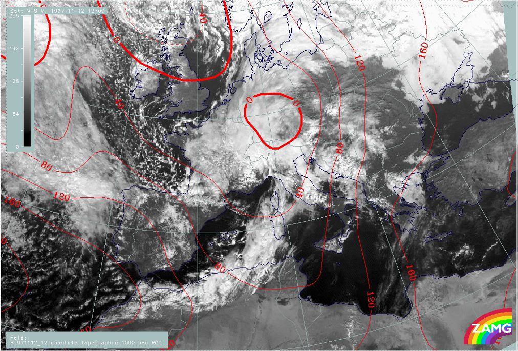
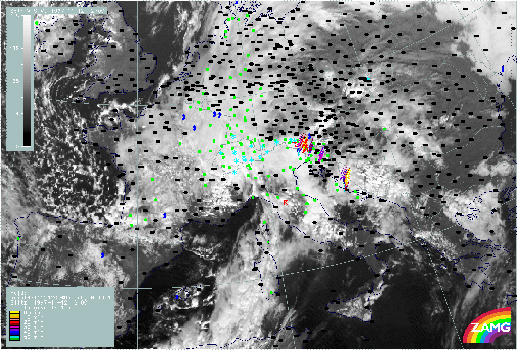
12 November 1997/12.00 UTC - Meteosat VIS image; red: height contours 1000 hPa
|
|
|
The VIS image superimposed by the 1000 hPa height surface adds some more information:
- There is a notable discrepancy between the main surface minimum over south Germany and the spiral configuration with its centre over north-west Italy; this is discussed and explained later;
- In contrast to the IR image, in which high lee cloudiness can be identified within the thickness ridge cloudiness over the Balkan Peninsula, the main characteristic in the VIS image is the lower lee cloudiness in the form of parallel cloud lines, as for instance over central Italy in the lee of the Apennines and the Croatian coast, and Bosnia and Yugoslavia in the lee of the Balkan mountains.
|
12 November 1997/12.00 UTC - Meteosat WV image; red: height of PV = 2 units
|
|
|
The WV imagery, together with the height of the PV = 2 unit surface, does not contain new features. There is black dry air on the rear side of the frontal cloud system with very dry stratospheric air down to approximately 400 hPa over Spain behind that jet streak that caused the intensification in the frontal cloud band. In the area of the wave the tropopause is at about 300 - 350 hPa which is quite common for these kinds of Waves.
Diagnosis of front and Wave(s)
|
12 November 1997/12.00 UTC - Meteosat IR image; blue: thermal front parameter (TFP) 500/850 hPa, green: equivalent thickness 500/850
hPa, red: temperature advection - WA 1000 hPa
|
|
|
The front parameters in the image above describe a very well-pronounced Cold Front with high thickness gradients within the frontal cloud band. The biggest part of the cloud band, or at least the one west of Italy, is still under CA. This is of special interest for the intensification area over the Algerian coast where the jet crossing takes place. Although a quick inspection of the cloud configuration might indicate a Wave development there, the temperature advection field contradicts this idea with a maximum of CA instead.
|
12 November 1997/12.00 UTC - Meteosat IR image; magenta: height contours 1000 hPa, red: temperature advection 1000 hPa
|
|
|
On the other hand, the TA field strongly supports the Wave situation over south Germany with an ideal connection between the surface minimum and the TA distribution: the zeroline of temperature advection runs through the centre of the surface low.
|
12 November 1997/12.00 UTC - Meteosat IR image; position of vertical cross section indicated
|
12 November 1997/18.00 UTC - Vertical cross section; black: isentropes (ThetaE), orange thin: IR pixel values, orange thick: WV pixel
values
|
|
|
This is supported in the vertical cross section immediately south of the area of interest showing two maxima of CA: one in the main frontal zone and another one in front of it corresponding to the area of Slovenia and Croatia.
|
12 November 1997/12.00 UTC - Meteosat IR image; green: height contours 500 hPa, yellow: positive vorticity advection (PVA) 500 hPa
|
12 November 1997/18.00 UTC - Vertical cross section; black: isentropes (ThetaE), green thick: vorticity advection - PVA, green thin:
vorticity advection - NVA, orange thin: IR pixel values, orange thick: WV pixel values
|
|
|
But as already mentioned the cloud configuration contradicts this very classical distribution of parameters relevant for a Wave: the cloud spiral is on the rear side of the surface minimum. The only explanation which can be found for such a remarkable deviation is the influence of the processes going on in upper levels. The left image shows a pronounced trough at 500 hPa exactly at the rear of, and intensive PVA over, the cloud spiral. In the same cross section as the one discussed before PVA (right image) shows a completely different behaviour in the two different areas of maximal CA, while over Slovenia and Croatia decrease of PVA with height takes place over the frontal surface. A pronounced increase of PVA with height is recognizable, which is connected with the main cloudiness there.
Relative streams: Cloudiness over the Balkan peninsula
|
12 November 1997/12.00 UTC - Meteosat IR image; position of vertical cross section indicated
|
12 November 1997/18.00 UTC - Vertical cross section; black: isentropes (ThetaE), orange thin: IR pixel values, orange thick: WV pixel
values
|
|
|
|
|
|
12 November 1997/12.00 UTC - Meteosat IR image; black: shear vorticity 300 hPa, magenta: relative streams 311K - system velocity
230° 10 m/s, yellow: isotachs
|
|
In the bottom left image the different relative streams involved in the synoptic situation can be clearly separated on the ThetaE surface of 311K which is on top of the frontal zone:
- The Warm Conveyor Belt from south-east which is rising while turning to the north-east over the Balkan Peninsula; it is responsible for the development of the cloudiness there;
- The humid relative stream from the rear side of the front but on the anticyclonic side of the jet axis which can be found in the leading part of the frontal cloud band;
- The dry intrusion which is to a certain degree superimposed on the rearward part of the frontal cloud band at this time. The process of jet streak crossing seems to be the reason that at higher levels dry air overruns the southern parts of the frontal cloud band under sinking motion, especially in the area of Algeria and Tunisia. This will have serious consequences and will be followed in the later points of time.
Comparison of cloud configurations between 12.00 and 18.00 UTC
|
12 November 1997/12.00 UTC - Meteosat IR image
|
12 November 1997/12.00 UTC - Meteosat WV image
|
|
|
|
|
|
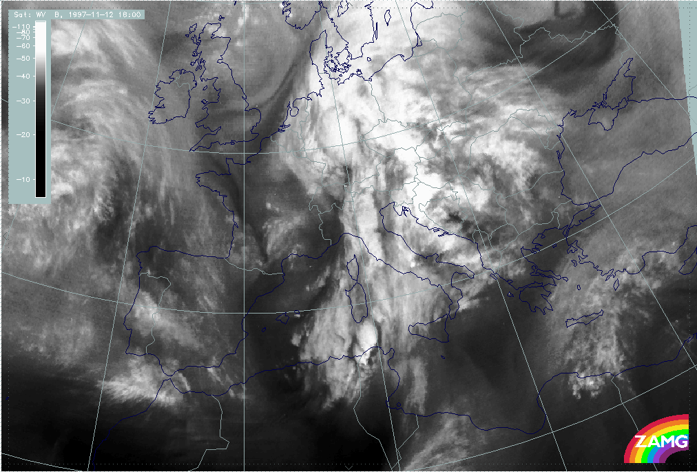
12 November 1997/18.00 UTC - Meteosat IR image
|
12 November 1997/18.00 UTC - Meteosat WV image
|
A comparison of the cloud configurations at 12.00 UTC (left and right image top) with those in the IR and WV imagery for 18.00 UTC (left and right image bottom) can be summarized into four topics:
- The Wave structure over the west Alps has moved northward without any further development of the spiral structure;
- The area of the Front Intensification by Jet Crossing has further intensified with a wave-like bulge recognizable between the Algerian coast and Sardinia and some very notable Cb developments between the Tunisian coast and south Sardinia. The latter do not only show the typical shape of Cb cells but also a dry zone around them representing sinking air; all thunderstorm events and their synoptic environment are discussed in a separate chapter (compare Development of Thunderstorms and MCSs During the Whole Period);
- The cloudiness in front of the frontal system over the Balkan Peninsula is still discernible and even more intensive, especially over east Slovenia and Croatia which indicates convective developments there;
- High fibrous cloudiness in band form has developed over Libya and has reached the Mediterranean coast.
Overall situation and frontal diagnosis
|
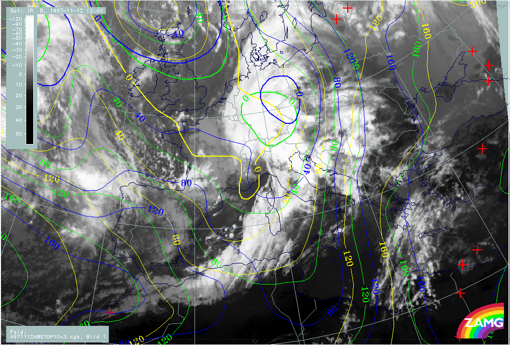
12 November 1997/18.00 UTC - Meteosat IR image; red: height contours 1000 hPa, green: height contours 500 hPa
|
|
|
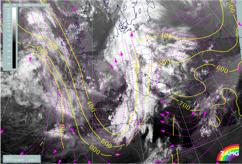
The image above shows an unchanged situation between cloud configuration on the one hand and surface and upper level height on the other. The cloud spiral is not in agreement with the surface low but with a mesoscale upper level trough there. In the area of the front intensification between Algeria and Sardinia the upper level trough has become even more distinct.
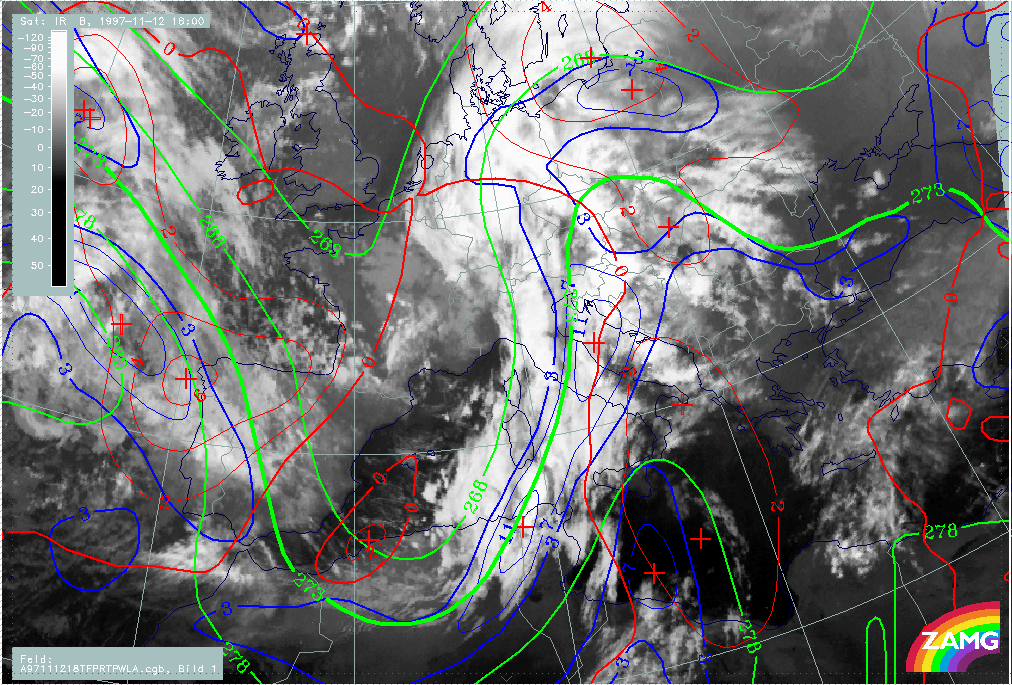
|
12 November 1997/18.00 UTC - Meteosat IR image; blue: thermal front parameter (TFP) 500/850 hPa, green: equivalent thickness 500/850
hPa, red: temperature advection - WA 500/1000 hPa
|
12 November 1997/18.00 UTC - Meteosat IR image; yellow: isotachs 300 hPa, red: vorticity advection 300 hPa
|
|
|
There is also no change in the frontal situation (left image). The Cold Front represented by the TFP has reached central Austria, central Slovenia and the westernmost coast areas of Croatia. As with six hours earlier the intensification area between Algeria and Sardinia does not represent a classical Wave situation because of the absence of any WA area there. But as can be seen from the right image a very distinct situation of a jet streak crossing takes place there, with the isotach maximum crossing the front nearly perpendicularly and the PVA maximum in the left exit region superimposed exactly on the frontal intensification area.
|
12 November 1997/18.00 UTC - Meteosat IR image; position of vertical cross section indicated
|
12 November 1997/18.00 UTC - Vertical cross section; black: isentropes (ThetaE), orange thin: IR pixel values, orange thick: WV pixel
values
|
|
|
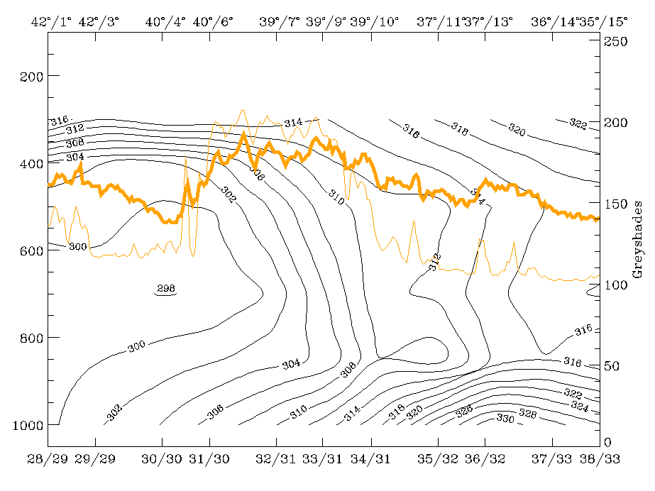
This area of the front shows also interesting and characteristic behaviour in the vertical cross section. In the right image the isentropes (ThetaE) clearly show a frontal crowding zone inclined from approximately 39N/06E at 400 hPa downward to about 900 hPa at 38N/10E where it pushes at a boundary layer with surface-parallel isentropes representing a very warm air pillow. Another zone of inclined isentropes can be seen more in the east of this vertical cross section (around 13E) where the transition from CA to WA takes place. The nearly vertical inclination is not characteristic of a classical front, but it cannot be ignored that some air mass transitions are taking place there. This will be mentioned below in connection with the relative streams.
|
12 November 1997/18.00 UTC - Vertical cross section; black: isentropes (ThetaE), magenta thin: divergence, magenta thick: convergence,
orange thin: IR pixel values, orange thick: WV pixel values
|
12 November 1997/18.00 UTC - Vertical cross section; black: isentropes (ThetaE), cyan thick: vertical motion (omega) - upward motion,
cyan thin: vertical motion (omega) - downward motion, magenta thin: divergence, magenta thick: convergence, orange thin: IR pixel
values, orange thick: WV pixel values
|
|
|
|
|
|
12 November 1997/18.00 UTC - Vertical cross section; black: isentropes (ThetaE), lilac: Q-Vector (normal component), orange thin: IR
pixel values, orange thick: WV pixel values
|
|
But there are also other important frontal features in this vertical cross section. The left and right top images show that the western frontal surface is connected with a distinct zone of convergence from the surface up to 400 hPa leading to upward motion on top of the frontal zone, especially pronounced in middle levels. Also the n-component of the Q-vector used as a frontogenetic parameter indicates pronounced frontogenesis (left image bottom). Both divergence and frontogenesis do not separate the boundary layer from the frontal layer.
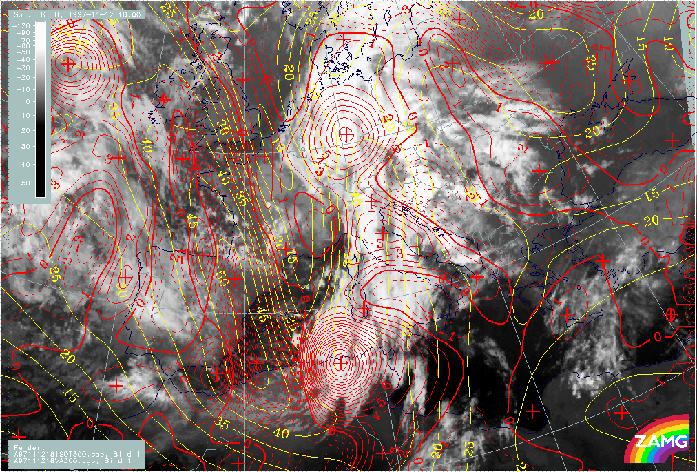
Relative streams
|
12 November 1997/18.00 UTC - Meteosat IR image; position of vertical cross section indicated
|
12 November 1997/18.00 UTC - Vertical cross section; black: isentropes (ThetaE), orange thin: IR pixel values, orange thick: WV pixel
values
|
|
|
|
|
|
12 November 1997/18.00 UTC - Meteosat IR image; black: shear vorticity 300 hPa, magenta: relative streams 312K - system velocity
232° 11 m/s, yellow: isobars
|
|
Few if any changes took place involving different relative streams (left image bottom). The most important facts can be summarised as follows:
- The rising Warm Conveyor Belt is responsible for the cloudiness over the Balkan Peninsula in front of the frontal system;
- Both relative streams from behind the front are involved in the frontal cloud band;
- A dry air stream connected with the crossing jet streak on its cyclonic side penetrates into the area in front of the frontal cloud band over Tunisia and the adjacent Mediterranean Sea.
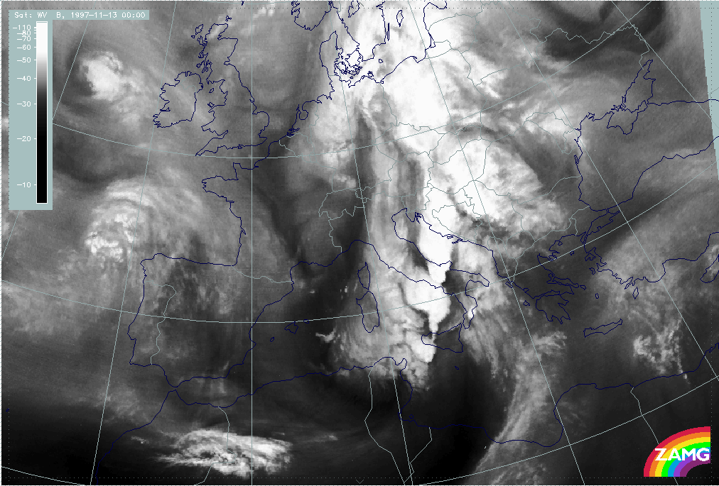
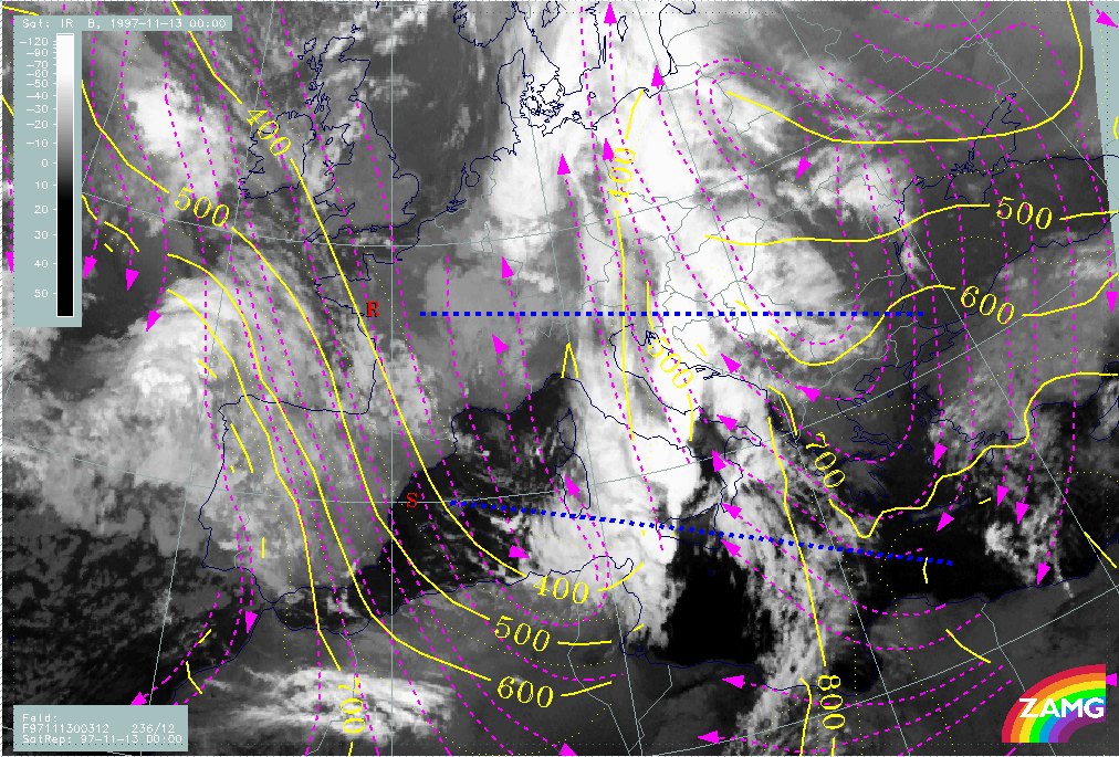
Introduction for 13 November 00.00 UTC
|
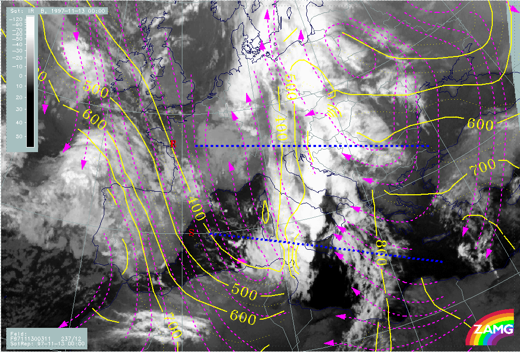
13 November 1997/00.00 UTC - Meteosat IR image
|
13 November 1997/00.00 UTC - Meteosat IR image
|
|
|
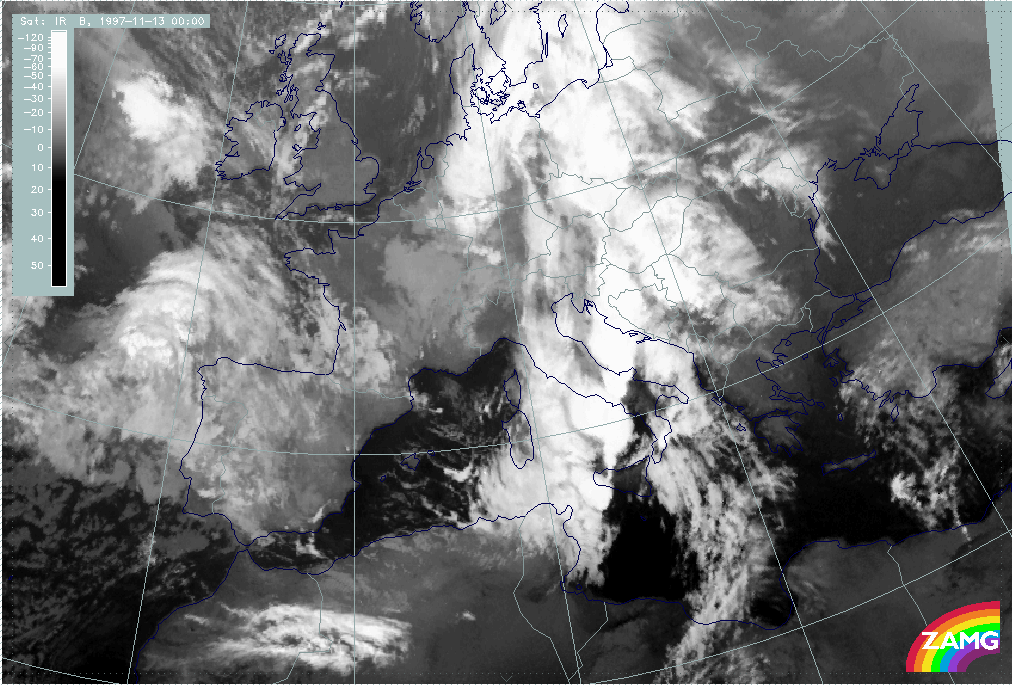
The IR and WV images from 13 November 00.00 UTC (left and right image) show somewhat changed features:
- The former Wave area and spiral structure has moved to north Germany and will no longer be discussed here;
- The Cold Front cloud band extends from Tunisia across Italy, Slovenia and Croatia northward to Hungary and Poland; there are a lot of substructures mentioned below;
- The intensification area released through jetstreak crossing is still recognisable between Tunisia, Sicily and Sardinia. It develops more and more a spiral structure; there is intensive Cb and MCS development at the leading side of the frontal cloud band from Sardinia northward to Croatia which will be discussed in a separate chapter together with the synoptic environment (compare Development of Thunderstorms and MCSs During the Whole Period);
- A fibrous cloud band with cyclonic curvature extending from Tunisia and Syria northward to south Italy has further developed since 18.00 UTC when it was first recognized; there is a very dry area between the two cloud bands there;
- With the eastward approach of the Cold Front cloud band the cloudiness over the Balkan Peninsula becomes less pronounced.
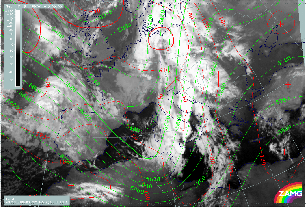
Overview and frontal situation
|
12 November 1997/18.00 UTC - Meteosat IR image; red: height contours 1000 hPa, green: height contours 500 hPa
|
13 November 1997/00.00 UTC - Meteosat IR image; red: height contours 1000 hPa, green: height contours 500 hPa
|

|
|
There is a zone of low pressure areas close to the surface (right image) from the former Wave over north Germany and east Poland across east Austria and the Adriatic Sea to an extended trough south of Sicily. The latter is in front of the Cold Front band but on the rear side of the newly formed fibrous cloud band. Such a surface low could already be recognised six hours before (left image) but only now can it be associated with this new cloud band.
|
13 November 1997/00.00 UTC - Meteosat IR image; blue: thermal front parameter (TFP) 500/850 hPa, green: equivalent thickness 500/850
hPa, red: temperature advection - WA 1000 hPa
|
|
|
|
The upper level trough is very distinct and reaches from the Netherlands southward to Tunisia where curvature vorticity is very pronounced (not shown here). This curvature vorticity leads to the spiral form of the frontal cloud band there which is, however, still not a sign for a classical Wave development as can be concluded from the TA field in the image above. On the contrary, the synoptic situation there seems to be connected with the development of the eastern fibrous cloud band which is under the influence of WA.
The maximum line of the TFP, which represents the conventional front line, extends from north Tunisia across the Adriatic Sea and west Croatia to west Hungary and further northward. It is accompanied from Sicily northward as far as Croatia by extensive Cb and MCS developments. These will be discussed together with the synoptic environment in a separate chapter (compare Development of Thunderstorms and MCSs During the Whole Period).
|
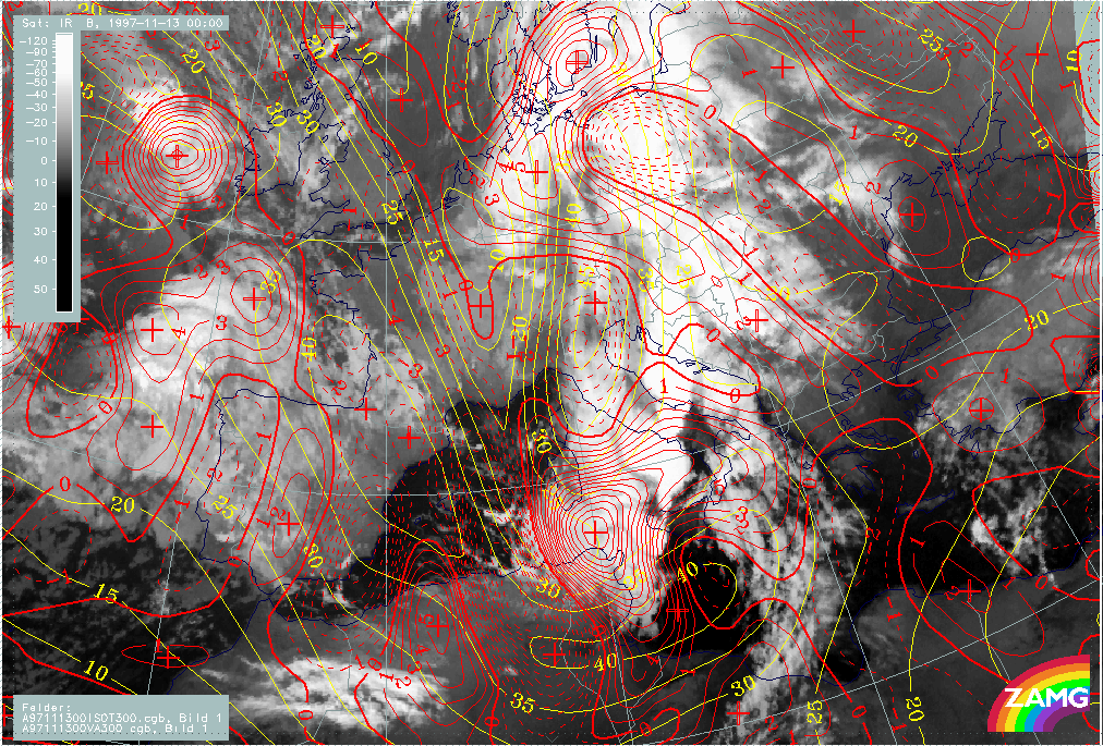
13 November 1997/00.00 UTC - Meteosat IR image; yellow: isotachs 300 hPa, red: vorticity advection 300 hPa
|
13 November 1997/00.00 UTC - Meteosat IR image; blue: shear vorticity 300 hPa, brown: curvature vorticity 300 hPa
|
|
|
|
|
|
13 November 1997/00.00 UTC - Meteosat WV image; yellow: Showalter index 500/850 hPa
|
|
In the image above (left image top) isotachs and PVA at 300 hPa are superimposed. Two or even three different cloud situations are explained by an interpretation of these parameter fields:
- There is still a huge PVA maximum superimposed on the front between Tunisia and Sardinia which is now produced by both the shear in the left exit region and the curvature in the pronounced upper level trough (right image top);
- But as a continuation from six hours earlier, a second jet streak has developed which extends from Tunisia eastward; it seems to be
responsible for two effects:
- Dry air propagating ahead of the Cold Front and causing the very black area in the WV image there (left image bottom)
- A lobe of PVA extending from approximately 39N/12E - south Italy which is in the left exit region of the new jet streak and mainly caused by shear (right image top).
|
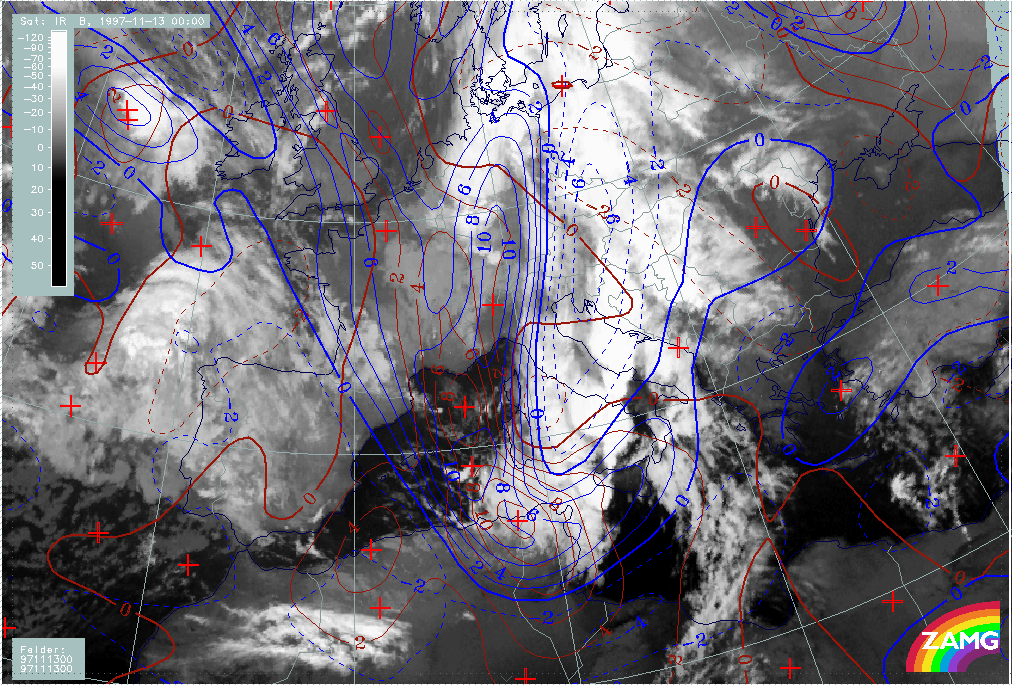
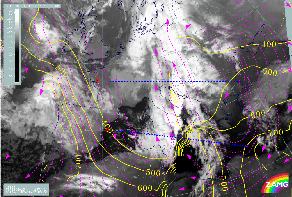
13 November 1997/00.00 UTC - Meteosat IR image; position of vertical cross sections R and S indicated
|
|
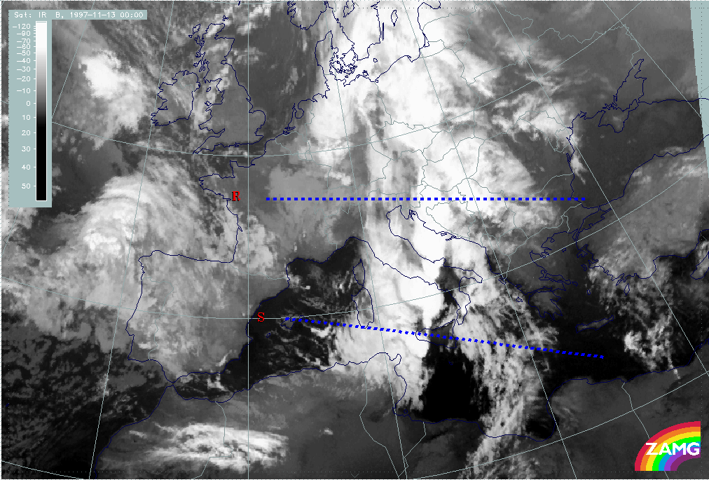
|
In the image above two vertical cross sections are indicated which are discussed in more detail in the following paragraphs: the northern one crosses Slovenia and Croatia (cross section R), the southern one crosses Sicily (cross section S).
|
13 November 1997/00.00 UTC - Vertical cross section R; black: isentropes (ThetaE), red thin: temperature advection - CA, red thick:
temperature advection - WA, orange thin: IR pixel values, orange thick: WV pixel values
|
13 November 1997/00.00 UTC - Vertical cross section R; black: isentropes (ThetaE), magenta thin: divergence, magenta thick:
convergence, orange thin: IR pixel values, orange thick: WV pixel values
|
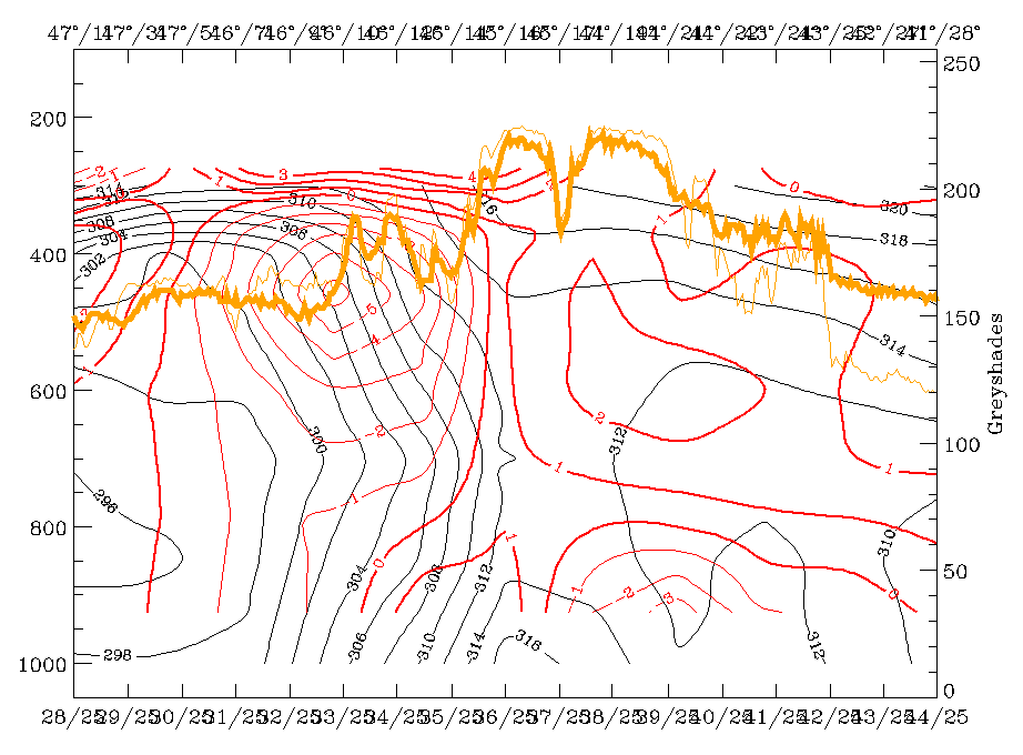
|
|
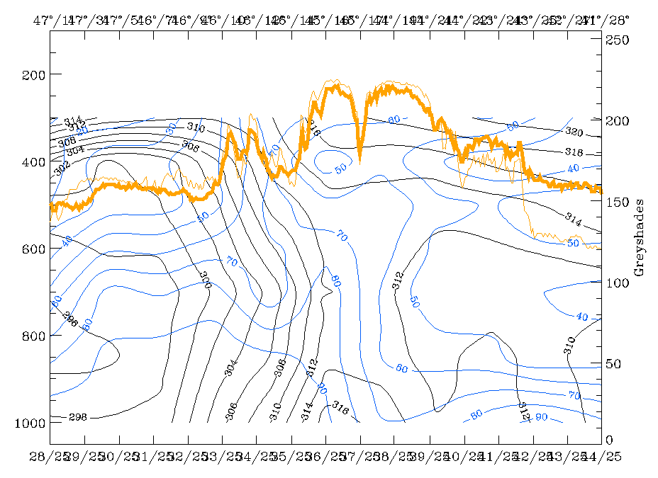
The most important features in the northern cross section R is the very steep frontal surface with superadiabatic inclination in the lower layer and consequently WA up to 800 hPa with CA above. This is a typical condition for an unstable situation. Further to this, there is significant convergence not within but in front of the frontal surface. Both features may play an important role for the intensive thunderstorm development there.
|
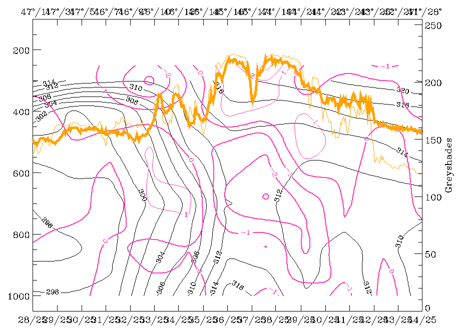
13 November 1997/00.00 UTC - Vertical cross section S; black: isentropes (ThetaE), red thin: temperature advection - CA, red thick:
temperature advection - WA, orange thin: IR pixel values, orange thick: WV pixel values
|
13 November 1997/00.00 UTC - Vertical cross section S; black: isentropes (ThetaE), magenta thin: divergence, magenta thick:
convergence, orange thin: IR pixel values, orange thick: WV pixel values
|
|
|
The southern vertical cross section S shows rather classical Cold Front conditions, but somewhat different conditions for the thunderstorm development there. In the left and right images the frontal surface can be localised from 39N/08E at about 350 hPa down to the surface at 37N/11E where also a thunderstorm is reported. But the frontal surface is under CA. Differences can also be recognized in the convergence which accompanies only the frontal zone with maximal values. The thunderstorm report fits very well to the convergence accompanying the low frontal zone and to the PVA maximum increasing with height (left image below).
|
13 November 1997/00.00 UTC - Vertical cross section S; black: isentropes (ThetaE), green thick: vorticity advection - PVA, green thin:
vorticity advection - NVA, orange thin: IR pixel values, orange thick: WV pixel values
|
13 November 1997/00.00 UTC - Vertical cross section S; cyan thick: vertical motion (omega) - upward motion, cyan thin: vertical motion
(omega) - downward motion, green thick: vorticity advection - PVA, green thin: vorticity advection - NVA, orange thin: IR pixel values,
orange thick: WV pixel values
|
|
|
The right image above shows the connection between PVA and omega. There are two maxima on top of the frontal zone: from the surface up to about 650 hPa which seems to be connected with the convergence cell, and a second one centred at 500 hPa which is connected with the PVA maximum.
|
13 November 1997/00.00 UTC - Vertical cross section; black: isentropes (ThetaE), lilac: Q-Vector (normal component), orange thin: IR
pixel values, orange thick: WV pixel values
|
|
|
The image above finally shows that there is further frontogenesis in this area of the cloud band, a situation which also has continued from six hours before.
Relative streams: Frontal and pre-frontal situation
At this point of time the area of most interest moved away from the cloudiness in front of the Cold Front to the area of the Cold Front cloud band itself, where during the last six hours a line of large thunderstorms developed at the leading edge. The interpretation close to the superadiabatic frontal surfaces is quite difficult but still possible in view of a separation of relative streams, which have different origin.
|
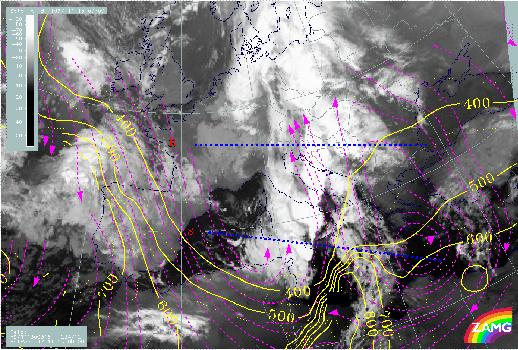
13 November 1997/00.00 UTC - Meteosat IR image; position of vertical cross sections R and S indicated
|
|

|
|
|
|
|
13 November 1997/00.00 UTC - Vertical cross section R; black: isentropes (ThetaE), blue: relative humidity, orange thin: IR pixel
values, orange thick: WV pixel values
|
13 November 1997/00.00 UTC - Vertical cross section S; black: isentropes (ThetaE), blue: relative humidity, orange thin: IR pixel
values, orange thick: WV pixel values
|
In the northern vertical cross section (cross section R) crossing Croatia, the ThetaE surface 312K is on top of the frontal surface and is inclined very steeply and partly superadiabatic down to the surface; a tongue of wet air creeps upward to about 400 hPa (left image). A surface with similar features is ThetaE 311K for the southern vertical cross section S (right image). The interpretation has to consider that relative streams can only be interpreted down to about 700 hPa in the areas of interest; below this the isentropic surfaces are superadiabatic and nearly perpendicular to the surface. The isentropic surfaces 314K and 316K are already above the frontal surface and so in the area of interest the interpretation is not restricted.
|
13 November 1997/00.00 UTC - Meteosat IR image; magenta: relative streams 311K - system velocity 237° 12 m/s, yellow: isobars;
position of vertical cross sections R and S indicated
|
13 November 1997/00.00 UTC - Meteosat IR image; magenta: relative streams 311K - system velocity 236° 12 m/s, yellow: isobars;
position of vertical cross sections R and S indicated
|
|
|
Relative streams on 311K (left image) and 312K (right image) clearly show in the leading part of the frontal cloud band where the intensive thunderstorm clusters developed a strongly ascending relative stream from south-east, which can be called a Warm Conveyor Belt and is defined from 700 hPa upwards.
|
13 November 1997/00.00 UTC - Meteosat IR image; magenta: relative streams 314K - system velocity 237° 12 m/s, yellow: isobars;
position of vertical cross sections R and S indicated
|
13 November 1997/00.00 UTC - Meteosat IR image; magenta: relative streams 316K - system velocity 234° 12 m/s, yellow: isobars;
position of vertical cross sections R and S indicated
|
|
|
On 314K (left image) the layer higher than 500 hPa is defined for the northern vertical cross section (cross section R) but higher than 400 hPa for the southern vertical cross section (cross section S). While there is still a Warm Conveyor Belt in the northern cross section, in the southern cross section the much drier relative stream from behind the front has already approached the western parts of the thunderstorm cluster. This is very similar on 316K (right image) for the thunderstorm cell of the northern cross section, while for the southern Cb complexes on this surface the whole area is within the drier and colder relative stream from behind.
This situation will be of much interest for the interpretation of thunderstorms in the relevant chapter (compare Development of Thunderstorms and MCSs During the Whole Period).
Introduction for the diagnosis of conceptual modles for convective developments
There will be two different approaches for the diagnosis of conceptual models for convective developments:
The small scale approach
The diagnosis of convective developments with help of observations; the following material will be used:
- Satellite imagery: cold cloud top enhancement
- Weather reports
- Lightning reports
- Development images indicating new development and decay of cloudiness
In the satellite imagery typical configurations like cellular structures, circular and oval shapes and differences between IR and VIS are used for diagnosis. Development images will be used to try to get some information about life cycle and further development.
The meso - to synoptic scale approach
The description and use of conceptual models of the synoptic environment of the convective developments; the following material and tools are used:
- Overview in satellite imagery
- Stability index on isobaric surfaces: Showalter index
- Numerical model parameters on isobaric surfaces
- Numerical model parameters in vertical cross section; special attention is paid to:
- Vertical distribution of TA
- Vertical distribution of convergence
- Vertical distribution of PVA
- Relative streams for discrimination of different air masses
- PV (optionally)
The overview in the satellite imagery is also used to sort out configurations with cold cloud tops which are connected with non-convective conceptual models like, for instance, high Lee Cloud.
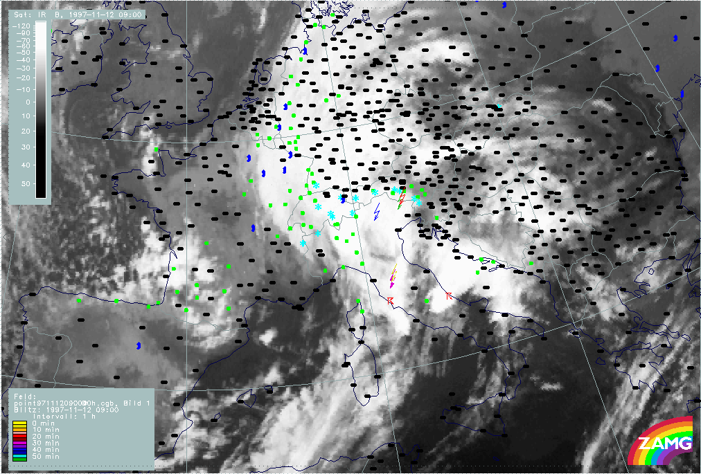
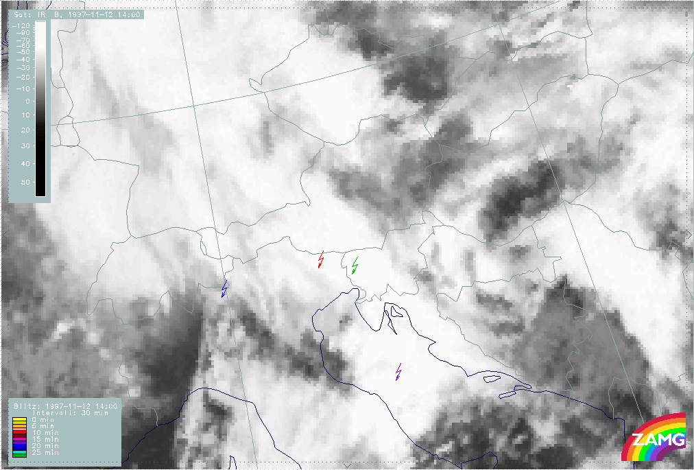
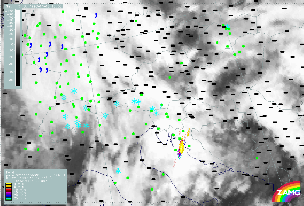
The period 12 November 05.00 - 07.00 UTC
Observational part
|
12 November 1997/06.00 UTC - Meteosat IR image; weather reports (green: rain and showers, blue: drizzle, cyan: snow, purple: freezing
rain, red: thunderstorm with precipitation, orange: hail, black: no actual precipitation or thunderstorm with precipitation)
|
|
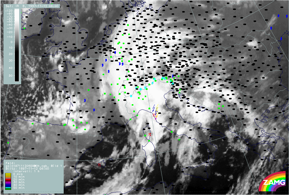
|
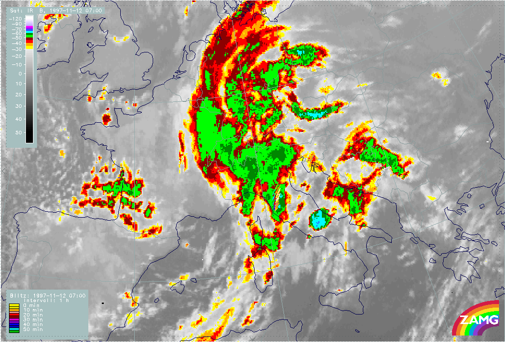
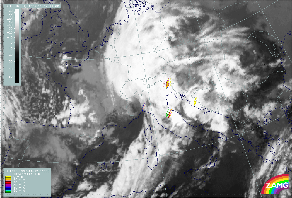
The image above shows two thunderstorm reports in an area between Corsica and Italy supplemented by lightning measurements in the Italian area during the last hour (yellow are the latest ones). These reports appear close to the leading parts of the Cold Front cloud band where there are some cellular structures which will be named Th1.
|
12 November 1997/06.00 UTC - Meteosat IR enhanced image
|
|
|
A visual inspection of images with help of an appropriate enhancement (image above) would also draw attention to the cells in the northern part of Sardinia and a very typical structure at the Italian coast around 41.5N/13E which has the coldest cloud tops of those mentioned. There are no lightning reports from this cell as it is not within the range of the lightning device. This cell is named Th2.
|
12 November 1997/06.00 UTC - Meteosat IR image; red: mean values of grey shades of cloud development and decay, cyan: cloud development
greater than 30 units, magenta: cloud decay greater than 20 units
|
|
|
The investigation of the development image can be seen in the image above. The 06.00 UTC IR image is superimposed by lines which represent mean development during the last hour. Positive values are cloud development, negative values cloud decay, the plus and minus signs enhance areas where an empirically determined threshold is reached. In the cellular area between Corsica and the Italian coast, which is accompanied by thunderstorm reports and can therefore be regarded as relatively weather active, a fully developed stage has already been reached without any further development during the last hour; on the contrary some decay has already taken place over Corsica and also over the central parts of the Italian mainland.
Appreciable development has taken place in the last hour in the area of the southern Italian cell Th2 which is therefore a new developing system (although not accompanied by weather reports because of its scale and distance).
Some new development happened also over north Italy (around 45N/11E) which is not supported by lightning reports yet. Over Slovenia and Croatia neither typical convective structures, nor very cold temperatures, nor appreciable development take place. The only area where the threshold for intensive development is exceeded is an extended area over east Croatia, which can be classified as high lee cloudiness.
|
12 November 1997/07.00 UTC - Meteosat IR image; lightning reports
|
12 November 1997/07.00 UTC - Meteosat IR image; red: mean values of grey shades of cloud development and decay, cyan: cloud development
greater than 30 units, magenta: cloud decay greater than 20 units
|
|
|
|
|
|
12 November 1997/07.00 UTC - Meteosat IR enhanced image
|
|
The images above show the situation for the next hour 06.00 - 07.00 UTC. The cellular area Th1 has moved eastward and is situated over Italy now. It is still accompanied by lightning reports over Italy (left image top around 44N/11E) although no notable new development of cloudiness has happened there (right image top). Pronounced new development has happened within the cell over middle Italy Th2 (42N/14E). Looking at the enhanced image (left image bottom) the coldest tops appear in the cell just mentioned but also in some smaller parts of the northern cellular area where the lightning reports come from.
In most of Slovenia and Croatia cloud dissolution prevails, while the high Lee Cloud in the east has strengthened there.
Synoptic environment part
From all observations available, two areas of convective and thunderstorm development could be selected as being of main interest: the one between Corsica and Italy (Th1) which is already well developed, and the cell over Italy south of it (Th2), which intensifies appreciably during this investigation period.
|
12 November 1997/06.00 UTC - Meteosat IR image; yellow: Showalter index 500/850 hPa, magenta: zero line of Showalter index 500/850 hPa,
lightning reports; position of vertical cross section indicated
|
12 November 1997/06.00 UTC - Meteosat IR image; blue: thermal front parameter (TFP) 500/850 hPa, green: equivalent thickness 500/850
hPa, red: temperature advection - WA 1000 hPa, yellow: positive vorticity advection (PVA) 500 hPa, lightning reports
|
|
|
The Showalter index (left image) indicates the whole area from Spain across Italy to east Austria and Slovakia as an area of high probability for thunderstorm development (Showalter index<3). But as can be seen from the right image there are completely different synoptic environmental conditions for the two convective areas under consideration. The northern one (Th1) appears at the leading edge of the Cold Front cloud band close to the frontal line (the TFP) within a Wave area and therefore under WA. The southern one (Th2) develops also under WA but far away from the frontal situation in the thickness ridge where the most unstable area is indicated by negative Showalter values. Notable PVA maxima are connected to the Wave but not in agreement with the Cb developments.
|
12 November 1997/06.00 UTC - Meteosat IR image; position of vertical cross section indicated
|
12 November 1997/06.00 UTC - Vertical cross section; black: isentropes (ThetaE), orange thin: IR pixel values, orange thick: WV pixel
values
|
|
|
The vertical cross section indicated in the left image above has been chosen with respect to the two convective areas Th1 and Th2; consequently it is not perpendicular to the frontal surface and the isentropes show a less pronounced gradient (right image). The frontal thunderstorm area (Th1) corresponds to the IR and WV peak at about 44N/10E, the single cell in the thickness ridge (Th2) is represented by the IR and WV peak close to 42N/13E.
|
12 November 1997/06.00 UTC - Vertical cross section; black: isentropes (ThetaE), red thin: temperature advection - CA, red thick:
temperature advection - WA, orange thin: IR pixel values, orange thick: WV pixel values
|
12 November 1997/06.00 UTC - Vertical cross section; black: isentropes (ThetaE), magenta thin: divergence, magenta thick: convergence,
orange thin: IR pixel values, orange thick: WV pixel values
|
|
|
|
|
|
12 November 1997/06.00 UTC - Vertical cross section; black: isentropes (ThetaE), green thick: vorticity advection - PVA, green thin:
vorticity advection - NVA, orange thin: IR pixel values, orange thick: WV pixel values
|
|
There are a lot of similarities between the two areas but also differences in the details:
- A rather thick superadiabatic layer which is more extended for the thickness ridge cell Th2;
- WA (left image top) but with differences in the vertical TA distribution: the frontal thunderstorm area Th1 is accompanied by WA below and CA above, while for the thickness ridge thunderstorm Th2, WA exists in the whole troposphere;
- Notable convergence (right image top) which takes place within but also in front of the frontal zone; for the frontal thunderstorm Th1 convergence is more intensive in the low layer and there is divergence above 600 hPa (which is the typical frontal circulation cell) while convergence is reaching into higher levels for the thickness ridge cell Th2;
- Increase of PVA with height (left image bottom).
For the relative streams involved the following isentropic surfaces have been selected:
- 309K which can be inspected for the frontal surface from 300 hPa downward to about 650 hPa at 44N/10E which is the area of the frontal thunderstorms Th1. For the thickness ridge cell Th2 this surface is not relevant;
- 310K which is still on top of the frontal surface and can be inspected from 300 hPa downward to about 700 hPa at 42N/13E which is the area of the thickness ridge cell Th2;
- 312K an undisturbed surface which is downward inclined between 300 and 500 hPa.
|
12 November 1997/06.00 UTC - Meteosat IR image; magenta: relative streams 309K - system velocity 248° 12 m/s, yellow: isobars,
lighting reports; position of vertical cross section indicated
|
12 November 1997/06.00 UTC - Meteosat IR image; black: shear vorticity 300 hPa, magenta: relative streams 310K - system velocity
248° 12 m/s, yellow: isobars, lighting reports; position of vertical cross section indicated
|
|
|
|
|
|
12 November 1997/06.00 UTC - Meteosat IR image; magenta: relative streams 312K - system velocity 248° 12 m/s, yellow: isobars,
lighting reports; position of vertical cross section indicated
|
|
On the 309K surface (left image top) a rising Warm Conveyor Belt can be recognized in the area of the frontal cells Th1; at 310K (right image top) the limiting streamline between the warm conveyor belt and the upper relative stream from behind crosses the cellular area Th1; and at 312K (left image bottom) the frontal thunderstorms Th1 are completely under the upper relative stream from behind. As the upper relative stream is somewhat cooler and drier than the Warm Conveyor Belt, an unstable stratification of the troposphere develops there.
The thickness ridge cell Th2 appears on this surface within the Warm Conveyor Belt.
The period 12 November 11.00 - 12.00 UTC
Observational part
|
12 November 1997/09.00 UTC - Meteosat IR image; weather reports (green: rain and showers, blue: drizzle, cyan: snow, purple: freezing
rain, red: thunderstorm with precipitation, orange: hail, black: no actual precipitation or thunderstorm with precipitation)
|
|
|
The IR image superimposed by thunderstorm and lightning reports at 09.00 UTC may bridge the two phases (image above). The very white MCS extending from central Italy across the Adriatic Sea to the Croatian coast area has developed from the thickness ridge cell Th2 discussed in the chapter before (compare The period 12 November 05.00 - 07.00 UTC). The big white area of north-east Italy and west Austria accompanied by some lightning measurements has already been observed in the 06.00 UTC image as cellular area Th1. A cellular area at the Italian west coast east of Corsica is a new development and will be named Th3.
|
12 November 1997/11.00 UTC - Meteosat IR image; lightning reports
|
12 November 1997/11.00 UTC - Meteosat IR enhanced image
|
|
|
|
|
|
12 November 1997/11.00 UTC - Meteosat VIS image; lightning reports
|
|
Two hours later at 11.00 UTC the same three areas can be separated by their typical shape, their cold cloud tops and the lightning reports; also Th2 and Th3 show a distinct eastward movement.
|
12 November 1997/09.00 UTC - Meteosat IR image; red: mean values of grey shades of cloud development and decay, cyan: cloud development
greater than 30 units, magenta: cloud decay greater than 20 units
|
|
|
Additional information about the development stage of these complexes can be summarized with help of the development image: only the new convective development over Italy (Th3) is in a developing stage with production of new cloudiness during the last hour; the MCS over the Adriatic Sea and Croatia (Th2) shows production of new cloudiness only in the downstream areas over Croatia which is the anvil area, while upstream over the Adriatic Sea dissolution of cloudiness has occurred. The MCS over North Italy (Th1) is rather steady without any important new development.
|
12 November 1997/12.00 UTC - Meteosat IR image; weather reports (green: rain and showers, blue: drizzle, cyan: snow, purple: freezing
rain, red: thunderstorm with precipitation, orange: hail, black: no actual precipitation or thunderstorm with precipitation)
|
12 November 1997/12.00 UTC - Meteosat IR enhanced image
|
|
|
|
|
|
12 November 1997/12.00 UTC - Meteosat VIS image; weather reports (green: rain and showers, blue: drizzle, cyan: snow, purple: freezing
rain, red: thunderstorm with precipitation, orange: hail, black: no actual precipitation or thunderstorm with precipitation)
|
|
Two hours later at 12.00 UTC the MCS over the Adriatic sea (Th2) has moved further eastward influencing more and more Croatia and Bosnia. The MCS over north Italy (Th1) has also moved eastward into Slovenia with several lightning and thunderstorm reports there. The new development over central Italy (Th3) has further intensified and fills now the whole northern part of the Adriatic Sea. This area is still under development (image below) with formation of new cloudiness in nearly the whole cloud area. The other two MCSs Th1 and Th2 are connected with areas of weak decay of cloudiness.
|
12 November 1997/12.00 UTC - Meteosat IR image; red: mean values of grey shades of cloud development and decay, cyan: cloud development
greater than 30 units, magenta: cloud decay greater than 20 units
|
|
|
Synoptic environment part
|
12 November 1997/12.00 UTC - Meteosat IR image; yellow: Showalter index 500/850 hPa, lightning reports; position of vertical cross
section indicated
|
|
|
Similar to the first period about six hours before, the Showalter index shows with values below 3 units a situation with high probability for thunderstorm development in an area from the western Mediterranean across Italy and the Adriatic Sea to the Balkan Peninsula. The problem is that thunderstorm complexes do not develop everywhere in this large area but only where special conditions exist. As these small scale conditions cannot be filtered out from the larger scale material, the observational part takes over the task of thunderstorm identification.
|
12 November 1997/12.00 UTC - Meteosat IR image; blue: thermal front parameter (TFP) 500/850 hPa, green: equivalent thickness 500/850
hPa, red: temperature advection 1000 hPa, yellow: positive vorticity advection (PVA) 500 hPa, lightning reports
|
|
|
The image above shows the frontal and pre-frontal situation. The MCS over Croatia and Bosnia (Th2) is still within the thickness ridge in front of the Cold Front. On the contrary, the northern MCS over north Italy (Th1) exists within the frontal cloud band, and the new MCS under development over the northern Adriatic Sea (Th3) is close to the TFP but more in front of it than the northern MCS Th1. The distribution of the TA field in relation to the three MCSs is different and can more easily be discussed with the vertical cross sections.
|
12 November 1997/12.00 UTC - Meteosat IR image; yellow: positive vorticity advection (PVA) 500 hPa, black: positive vorticity advection
(PVA) 300 hPa, lightning reports
|
|
|
Despite the northern MCS Th1, which is within the frontal cloud band, the two other MCSs are not in any, or any important, relation to PVA maxima at height levels (image above).
|
12 November 1997/12.00 UTC - Vertical cross section; black: isentropes (ThetaE), orange thin: IR pixel values, orange thick: WV pixel
values
|
|

|
The vertical cross section used here crosses the two southern MCSs: the one over Croatia and Bosnia which is in a highly developed stage and the one over the Adriatic Sea which is in a development stage (compare the first image in the synoptic environment part). The image above contains a zone of downward inclined isentropes (from 550 hPa to about 700 hPa) accompanying the cold front; the left maximum in the IR and WV signals around 44N/10E represents the frontal cloudiness. Below 700 hPa there is a thick superadiabatic layer within the frontal surface as well as in front of it. The two other maxima in the satellite signals (between 43N/11E and 44N/14E as well as at 44N/16E) indicate the two MCSs Th3 and Th2. From the distribution of isentropes in this vertical cross section it seems to be much clearer that the developing MCS Th3 over the Adriatic Sea forms in front of and not at the frontal surface.
|
12 November 1997/12.00 UTC - Vertical cross section; black: isentropes (ThetaE), red thin: temperature advection - CA, red thick:
temperature advection - WA, orange thin: IR pixel values, orange thick: WV pixel values
|
12 November 1997/12.00 UTC - Vertical cross section; black: isentropes (ThetaE), magenta thin: divergence, magenta thick: convergence,
orange thin: IR pixel values, orange thick: WV pixel values
|
|
|
|
|
|
12 November 1997/12.00 UTC - Vertical cross section; black: isentropes (ThetaE), green thick: vorticity advection - PVA, green thin:
vorticity advection - NVA, orange thin: IR pixel values, orange thick: WV pixel values
|
|
As before, typical features in the relevant fields, as well as similarities and differences, are summarized:
- A thick superadiabatic layer for both MCSs;
- WA in low layers (left image top) but CA above in the middle troposphere which is a classical condition for an instability for both MCSs;
- Notable convergence (right image top) in a thick layer which takes place in front of the frontal zone;
- No PVA increase with height in connection with the two MCSs (left image bottom).
|
12 November 1997/12.00 UTC - Vertical cross section; black: isentropes (ThetaE), orange thin: IR pixel values, orange thick: WV pixel
values
|
|
|
For the relative streams involved the following isentropic surfaces have been selected:
- 310K which is on top of the frontal surface and can be followed from 300 hPa downward to about 700 hPa for the developing MCS Th3 over the Adriatic Sea;
- 312K, a surface which is downward inclined between 300 and 600 hPa and is relevant for both MCSs Th2 and Th3.
|
12 November 1997/12.00 UTC - Meteosat IR image; magenta: relative streams 310K - system velocity 230° 10 m/s, yellow: isobars,
lighting reports; position of vertical cross section indicated
|
12 November 1997/12.00 UTC - Meteosat IR image; magenta: relative streams 312K - system velocity 230° 10 m/s, yellow: isobars,
lighting reports; position of vertical cross section indicated
|
|
|
On the 310K surface (left image) the origin of the relative stream involved in the Adriatic MCS Th3 cannot clearly be determined. It might already be the relative stream from behind the cold front. In the area of the eastern MCS Th2 the Warm Conveyor Belt seems to be involved.
On the 312K surface (right image) the relative stream clearly originates from the rear of the Cold Front and represents the upper relative stream there.
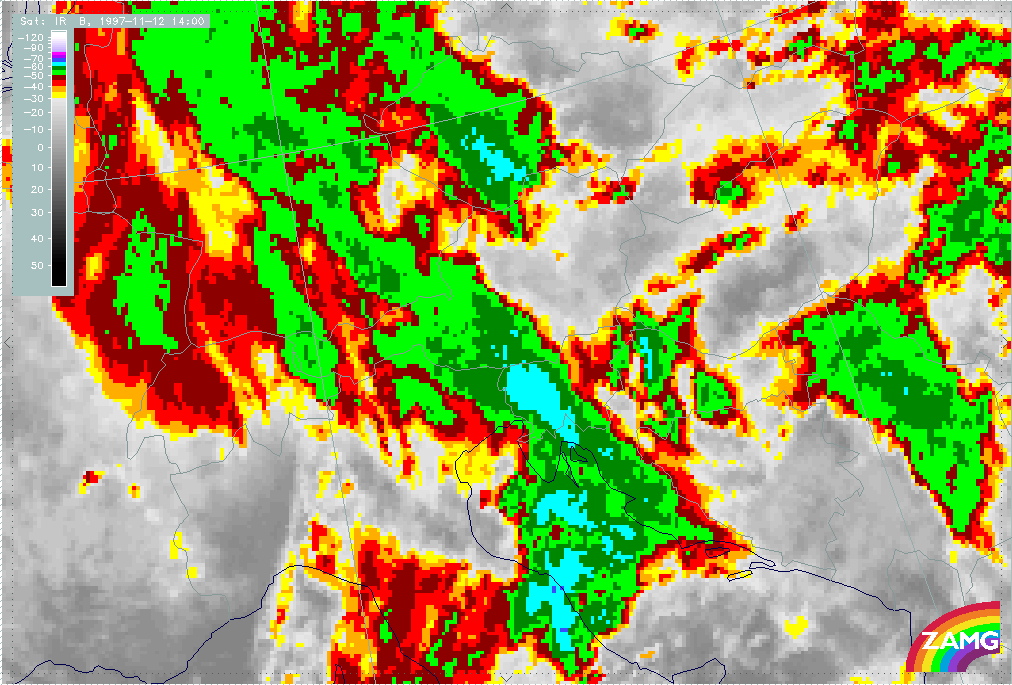
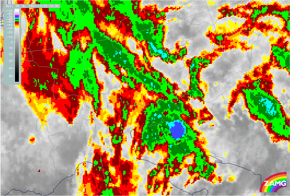
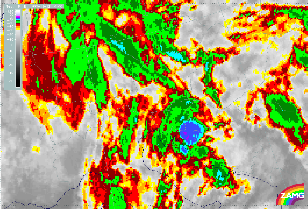
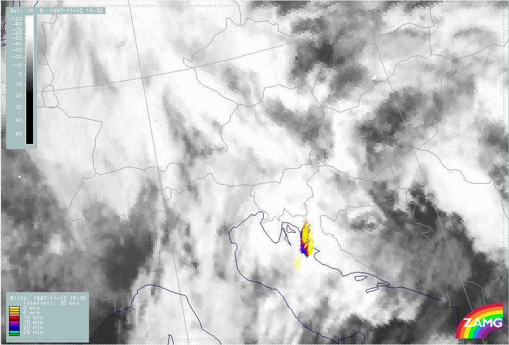
The period 12 November 14.00 - 18.30 UTC
Observational part
The period under consideration concentrates on some developments in the area north Adriatic Sea - Croatia - Bosnia - Slovenia which is the thunderstrom complex Th3 from the subperiod before. There are two separate periods with only half hourly time intervals; a fact which has to be taken into account if deviation values or lightning measurements are compared to the other periods based on one hourly intervals.
|
12 November 1997/14.00 UTC - Meteosat IR enhanced image
|
|
|
The image above can be used to establish the connection to the already discussed MCSs. There is an area of rather broken cloud cells around 46N/16E which is over east Croatia, north Bosnia and north Yugoslavia. This is the rest of the thunderstorm cell Th2, already detected as a fast growing system in the first period from 05.00 - 07.00 UTC over Italy, and again discussed as a fully developed MCS over the Croatian coast and Bosnia in the second period from 09.00 - 12.00 UTC. It has the appearance of a decaying system now.
A second area of interest is the bluish elongated area from south Austria across Slovenia to some parts of Croatia. This is the system Th1 which has been detected in the period 06.00 - 12.00 UTC within the frontal cloud band over north Italy.
A third area can be noticed over the Adriatic Sea around approximately 44N/14E reaching from the Italian to the Croatian coast areas. It has been discussed as a strongly developing MCS Th3 over Italy during the period 09.00 - 12.00 UTC; it will become the most interesting feature for this period.
|
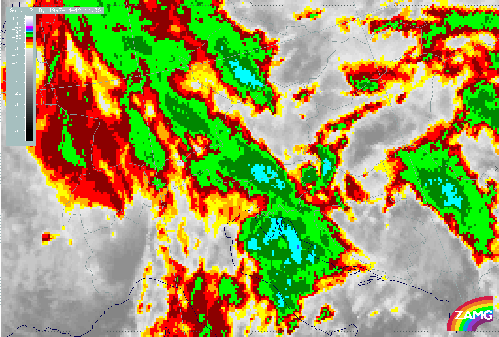
12 November 1997/14.30 UTC - Meteosat IR enhanced image
|
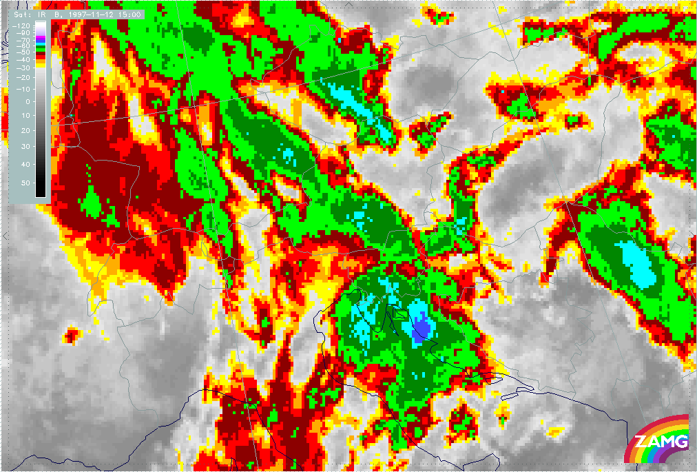
12 November 1997/15.00 UTC - Meteosat IR enhanced image
|
|
|
|
|
|
12 November 1997/15.30 UTC - Meteosat IR enhanced image
|
12 November 1997/16.00 UTC - Meteosat IR enhanced image
|
The sequence of half hourly enhanced IR images shows the developments from 14.00 to 16.00 UTC. At 14.30 UTC (left image top) the area with the coldest tops of the whole MCS Th3 has moved into the Croatian coast area with some small indication of the development of even colder tops around 44.5N/15E. During the next half hour a distinct development of colder tops has taken place and moved to the Croatian coast area around 45N/15E (right image top). This area broadens at the same location during the next half hour (15.00 - 15.30 UTC, left image bottom) and is shifted somewhat northward till 16.00 UTC (right image bottom) with a second very small cell downstream immediately at the coast. It has to be remembered that the features just discussed are local scale structures within the mesoscale structure of the whole MCS Th3, which covers an area from south-east Austria across Slovenia, Croatia and north Bosnia into the northern Adriatic Sea. The observation will be continued from 17.30 UTC later on.
|
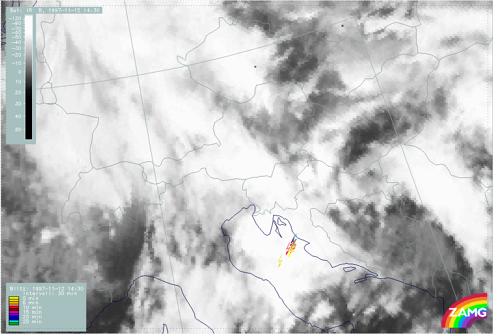
12 November 1997/14.00 UTC - Meteosat IR image; lightning reports
|
12 November 1997/14.30 UTC - Meteosat IR image; lightning reports
|
|
|
|
|
|
12 November 1997/15.00 UTC - Meteosat IR image; weather reports (green: rain and showers, blue: drizzle, cyan: snow, purple: freezing
rain, red: thunderstorm with precipitation, orange: hail, black: no actual precipitation or thunderstorm with precipitation)
|
12 November 1997/15.30 UTC - Meteosat IR image; lightning reports
|
|
12 November 1997/16.00 UTC - Meteosat IR image; lightning reports
|
|
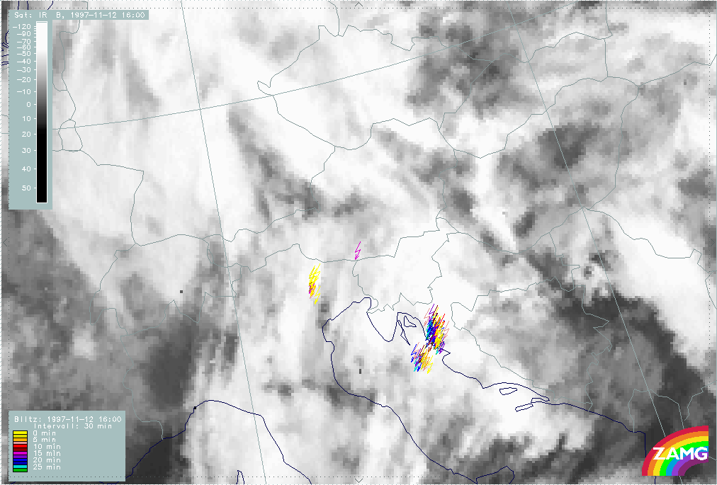
|
The sequence of half hourly lightning measurements superimposed on the satellite imagery supports the development of thunderstorms.
For the 14.00 UTC image (left image top) not too many lightning observations took place during the last half hour and the centre of main activity is the huge frontal cloud cell over north-east Italy and Slovenia. This changes dramatically during the next half hour till 14.30 UTC (right image top) where a lot of lightning over the Adriatic Sea is observed exactly where the development of the colder tops of the sub-cell takes place. The same can be noticed for 15.00 UTC (left image middle) and even more intensively for 15.30 (right image middle) where the yellow, actual lightning is observed over the Croatian coast. During the next half hour till 16.00 UTC (left image bottom) the lightning reports remain approximately in the same area and do not move with the coldest tops into the north, north-eastern parts of Croatia. So the lightning remains at the upstream part of this cellular substructure.
|
12 November 1997/15.00 UTC - Meteosat IR image; red: mean values of grey shades of cloud development and decay
|
12 November 1997/15.30 UTC - Meteosat IR image; red: mean values of grey shades of cloud development and decay
|
|
|
|
|
|
12 November 1997/16.00 UTC - Meteosat IR image; red: mean values of grey shades of cloud development and decay
|
|
The next series of images are the development images which contain the new development and decay of cloudiness in this MCS (Th3). It has to be remembered that the most pronounced development of colder tops within Th3 took place between 14.30 and 15.00 UTC. The first image (left image top) does not reflect this and at first glance even seems to be contradicting it: distinct development took place over the western boundary over the Italian coast and in the central Adriatic Sea while the biggest part of Th3 is under decay, but closer inspection leads to a small area with weak positive values exactly over the developing local scale cell. This shows the weaknesses and difficulties of the development images: one weakness is of course the size of the grid meshes used for the deviation computations; another problem seems to come from the fact that the interpretation of the values of mean deviation is different depending on where the new development happens: if new cloudiness is formed high values of mean deviation appear (this marks the changes from black to white); if cloudiness grows into colder heights, as is the case here, the values of mean deviation are rather small (this marks a change from white to even whiter).
The next two half hour periods are shown in the second image (right image top) and in the third image (left image bottom). The same results can be derived: there is mostly weak decay of cloudiness in the area of the MCS except for a small positive area in agreement with the local scale sub-cell.
|
12 November 1997/15.30 - 16.00 UTC - Meteosat IR development image
|
12 November 1997/15.00 - 16.00 UTC - Meteosat IR development image
|
|
|
Another result of this discussion is that the numerical values of deviation (new development) might not be indicative enough in these situations. The images above are the development images themselves with white areas representing new development, black areas decay and grey areas no development of cloudiness. What can clearly be seen in the area of interest is a circular (oval) feature with grey centre and lighter ring-like boundaries. This is a very characteristic feature for thunderstorm cells but for its identification additional methods seem to be necessary, like for instance object recognition methods.
|
12 November 1997/17.30 UTC - Meteosat IR enhanced image
|
12 November 1997/18.00 UTC - Meteosat IR enhanced image
|
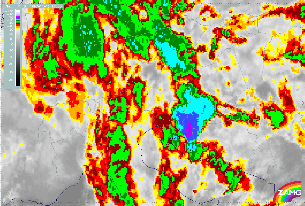
|
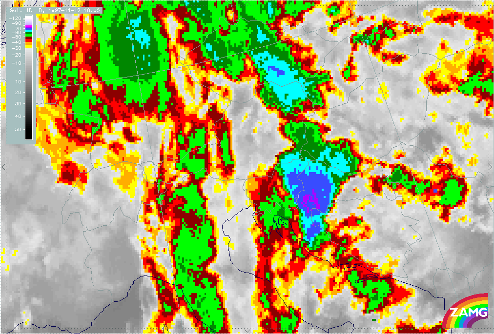
|
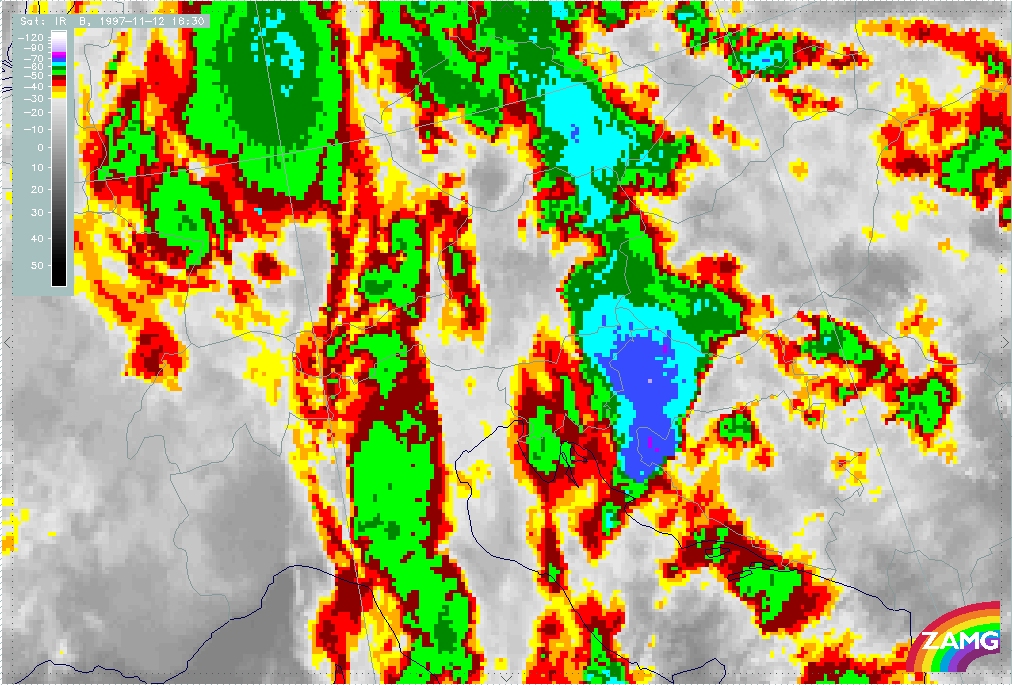
|
|
|
12 November 1997/18.30 UTC - Meteosat IR enhanced image
|
|
The second half hourly period is between 17.30 UTC and 18.30 UTC. At 17.30 UTC (left image top) the sub-cell has widened and covers north Croatia, east Slovenia and south-east Hungary. A smaller scale cell has developed upstream over the Croatian coast area. Till 18.00 UTC (right image top) a northward movement of both cell centres can be observed which is continued till 18.30 UTC (left image bottom) where for the first time a slight decay can be noticed.
|
12 November 1997/17.30 UTC - Meteosat IR image; lightning reports
|
12 November 1997/18.00 UTC - Meteosat IR image; lightning reports
|
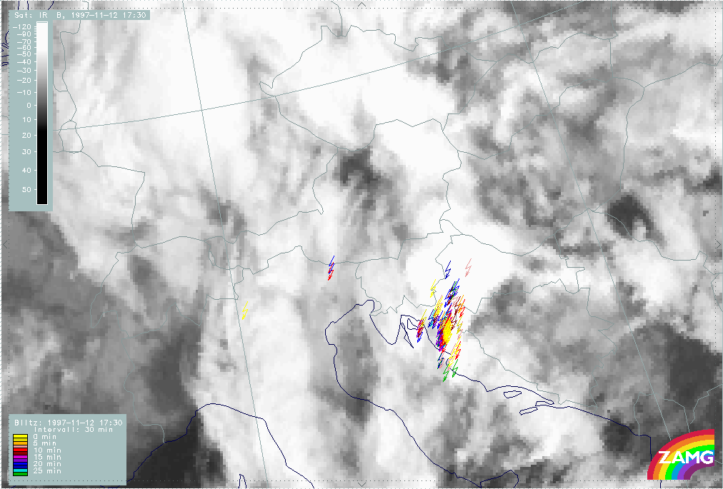
|
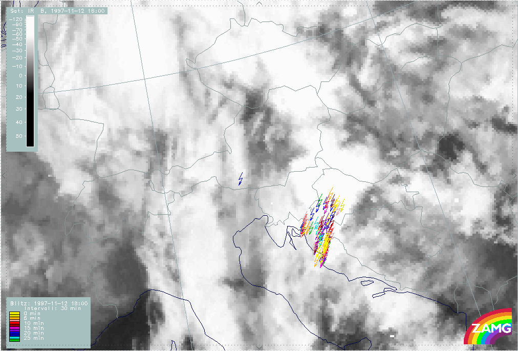
|
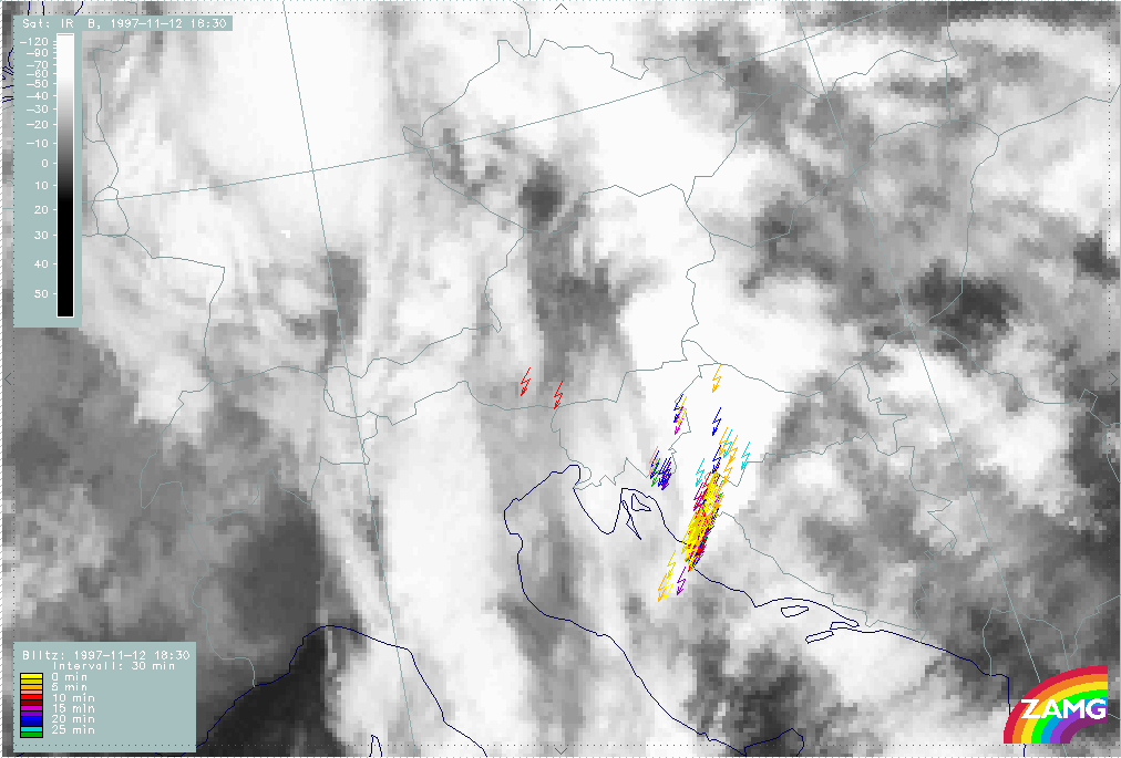
|
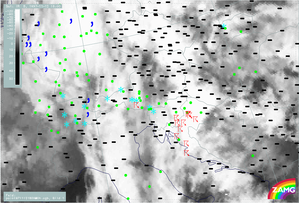
|
|
12 November 1997/18.00 UTC - Meteosat IR image; weather reports (green: rain and showers, blue: drizzle, cyan: snow, purple: freezing
rain, red: thunderstorm with precipitation, orange: hail, black: no actual precipitation or thunderstorm with precipitation)
|
|
Extended lightning activities are connected with the cell during this period with a concentration upstream at the coast area but extending also north-eastward till the end of the period. Additional to this, lots of thunderstorm reports exist for 18.00 UTC (right image bottom).
|
12 November 1997/18.30 UTC - Meteosat IR image; red: mean values of grey shades of cloud development and decay
|
|
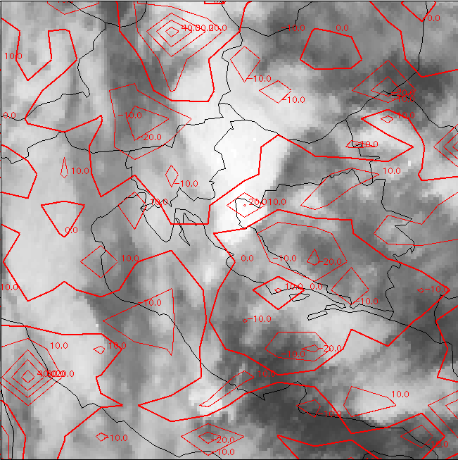
|
The development image for this last period 18.00 - 18.30 UTC shows the decay in a wide area from east Slovenia and north Croatia to Hungary, but also one area of new development in the upstream part over the Croatian coast area and north-west Bosnia.
Synoptic environment part
For 18.00 UTC the synoptic environment of this MCS Th3 will be investigated. As already noticed in the two earlier periods, the whole area has a high probability for thunderstorm development with values for the Showalter indices <3, partly also <0. In this image the line of the vertical cross section is superimposed which cuts the MCS Th3 under discussion.
|
12 November 1997/18.00 UTC - Meteosat IR image; blue: thermal front parameter (TFP) 500/850 hPa, green: equivalent thickness 500/850
hPa, red: temperature advection 1000 hPa, lightning reports
|
12 November 1997/18.00 UTC - Meteosat IR image; yellow: positive vorticity advection (PVA) 500 hPa, black: positive vorticity advection
(PVA) 300 hPa, lightning reports
|
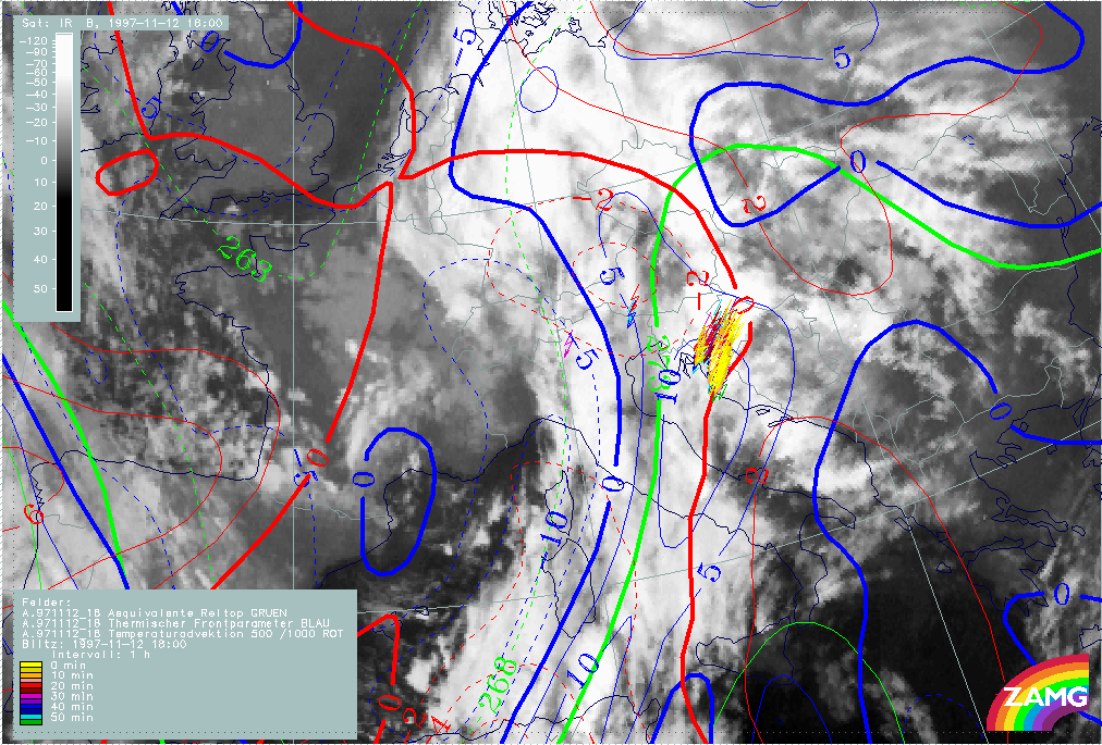
|
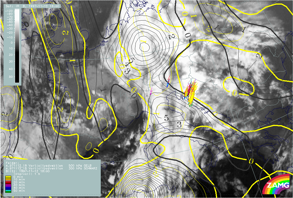
|
The image above (left image) shows that this MCS is very close to the Cold Front line (the TFP), especially in the upstream part and TA shows a transition from WA to CA there; this will be discussed in more detail later with help of the vertical cross section. PVA maxima at a height of 500 and 300 hPa (right image) do not show any connection with the Croatian MCS (Th3) but instead coincide with the intensification of cloudiness at the rear side of the frontal cloud band over Italy.
|
12 November 1997/18.00 UTC - Meteosat IR image; position of vertical cross section indicated
|
12 November 1997/18.00 UTC - Vertical cross section; black: isentropes (ThetaE), orange thin: IR pixel values, orange thick: WV pixel
values
|
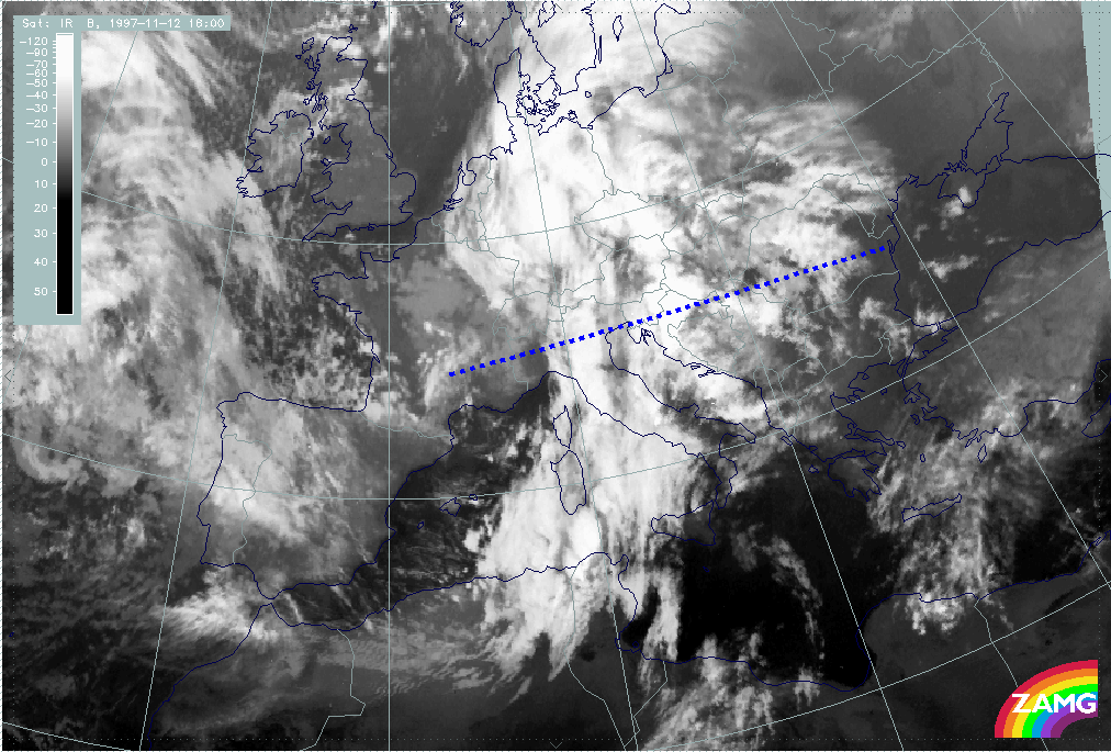
|
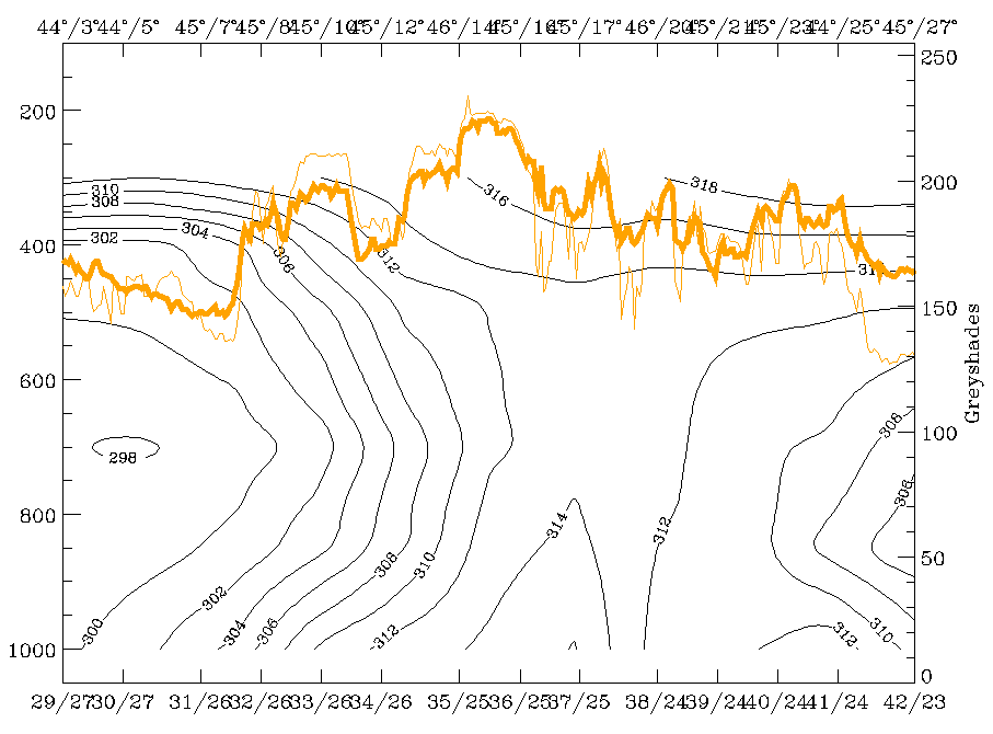
|
In the vertical cross section which extends perpendicularly through the Cold Front and the MCS Th3 over Croatia (left image), isentropes (right image) show a distinct frontal crowding zone from 300 - 400 hPa over 44N/06E (south France) down to the surface at about 45N/14E (west Slovenia and west Croatia). As in the periods discussed before, there is a distinct superadiabatic inclination of this surface below 700 hPa. Two maxima of IR and WV signals can be noticed in the frontal area: the more western one over Italy representing the frontal cloudiness and the main maximum representing the MCS Th3 over Slovenia and Croatia.
|
12 November 1997/18.00 UTC - Vertical cross section; black: isentropes (ThetaE), red thin: temperature advection - CA, red thick:
temperature advection - WA, orange thin: IR pixel values, orange thick: WV pixel values
|
12 November 1997/18.00 UTC - Vertical cross section; black: isentropes (ThetaE), magenta thin: divergence, magenta thick: convergence,
orange thin: IR pixel values, orange thick: WV pixel values
|
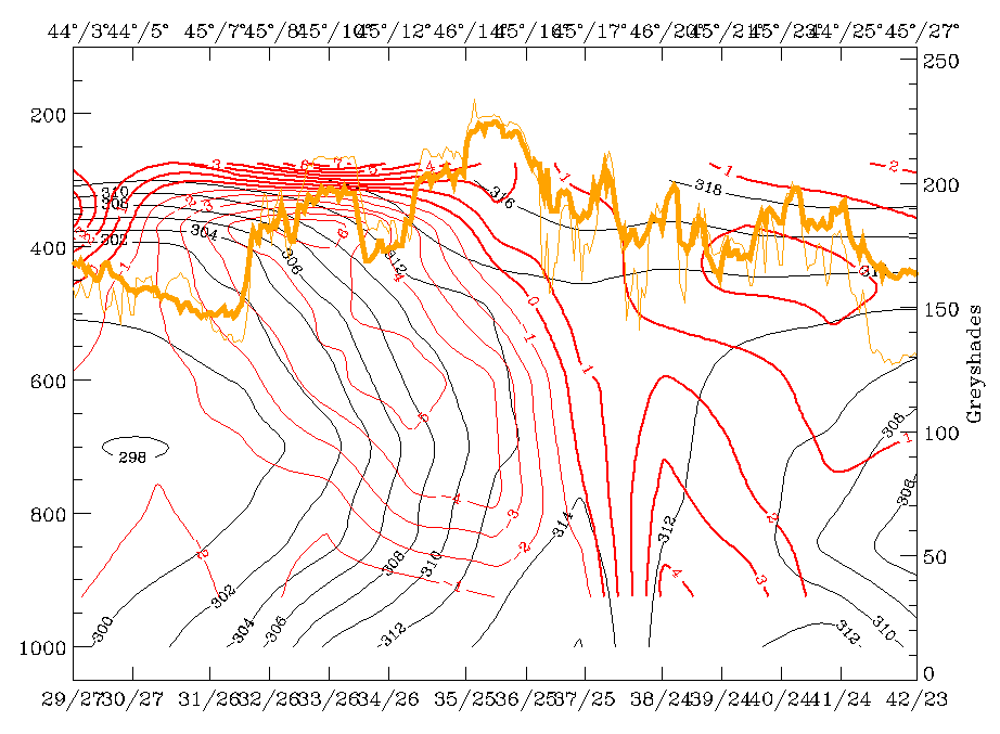
|
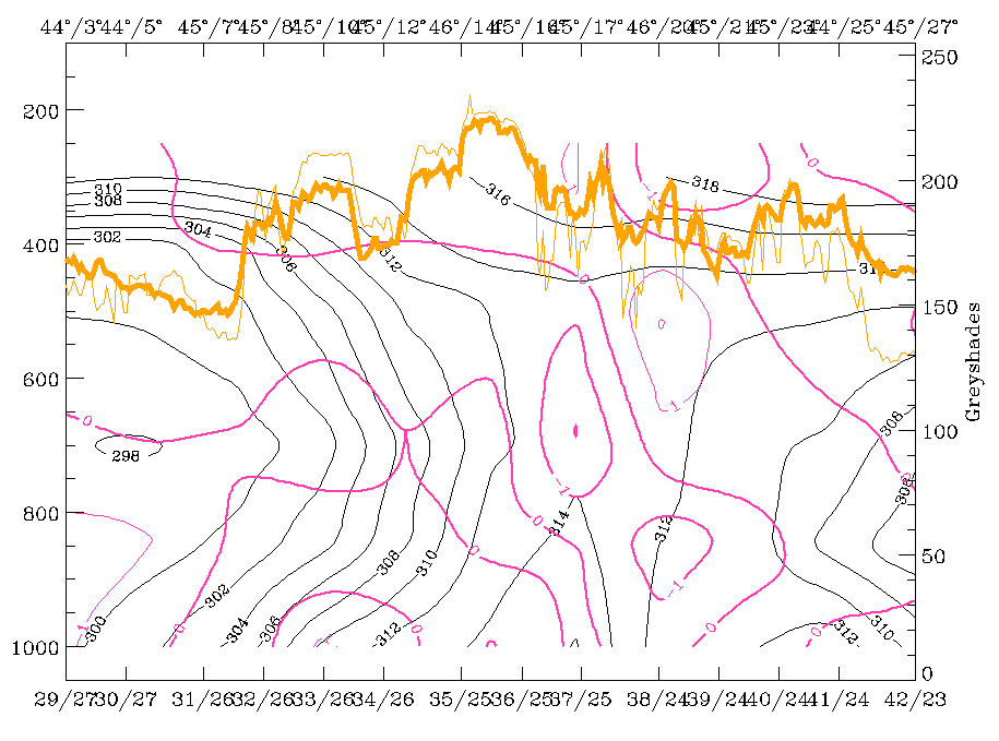
|
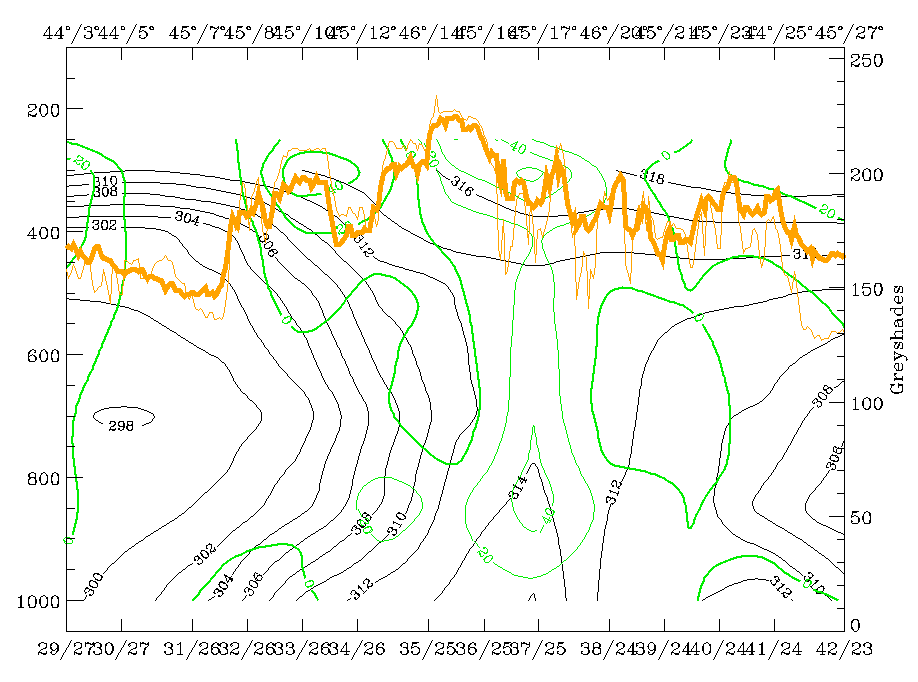
|
|
|
12 November 1997/18.00 UTC - Vertical cross section; black: isentropes (ThetaE), green thick: vorticity advection - PVA, green thin:
vorticity advection - NVA, orange thin: IR pixel values, orange thick: WV pixel values
|
|
The features in the vertical cross section can be summarised as follows:
- Superadiabatic frontal layer below 700 hPa;
- MCS at frontal surface;
- Deep layer of CA connected with cold front surface (left image top); if at all WA only in very low layers; this is different from all the other convective cells described till now where there was WA, at least in a low to middle layer;
- Although convergence (right image top) is rather weak in the area of the thunderstorm reports there is notable convergence in front of the frontal surface over approximately 45N/17E over east Croatia; a thick pre-frontal convergence layer was one feature common to the thunderstorm cells discussed so far;
- Increase of PVA with height (left image bottom) is connected with the western maxima of satellite signals and has nothing to do with the MCS Th3 under consideration.
|
12 November 1997/18.00 UTC - Vertical cross section; black: isentropes (ThetaE), orange thin: IR pixel values, orange thick: WV pixel
values
|
|
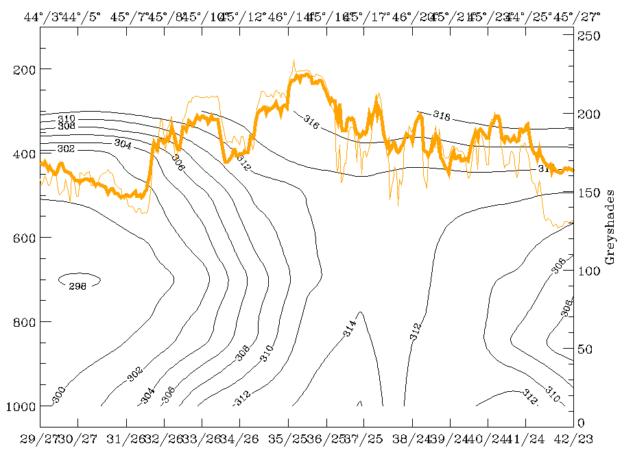
|
Although relative streams might be difficult to interpret in the frontal area because of the steep and partly also superadiabatic inclination, they are of major interest. Therefore two surfaces are chosen:
- ThetaE 312K is on top of the frontal surface and can be followed in the area of the frontal convective feature Th3 down to 500 hPa;
- ThetaE 314K is an undisturbed surface immediately above and indicates a layer between 300 and 450 hPa.
|
12 November 1997/18.00 UTC - Meteosat IR image; magenta: relative streams 312K - system velocity 232° 11 m/s, yellow: isobars,
lighting reports; position of vertical cross section indicated
|
12 November 1997/18.00 UTC - Meteosat IR image; magenta: relative streams 314K - system velocity 232° 11 m/s, yellow: isobars,
lighting reports; position of vertical cross section indicated
|
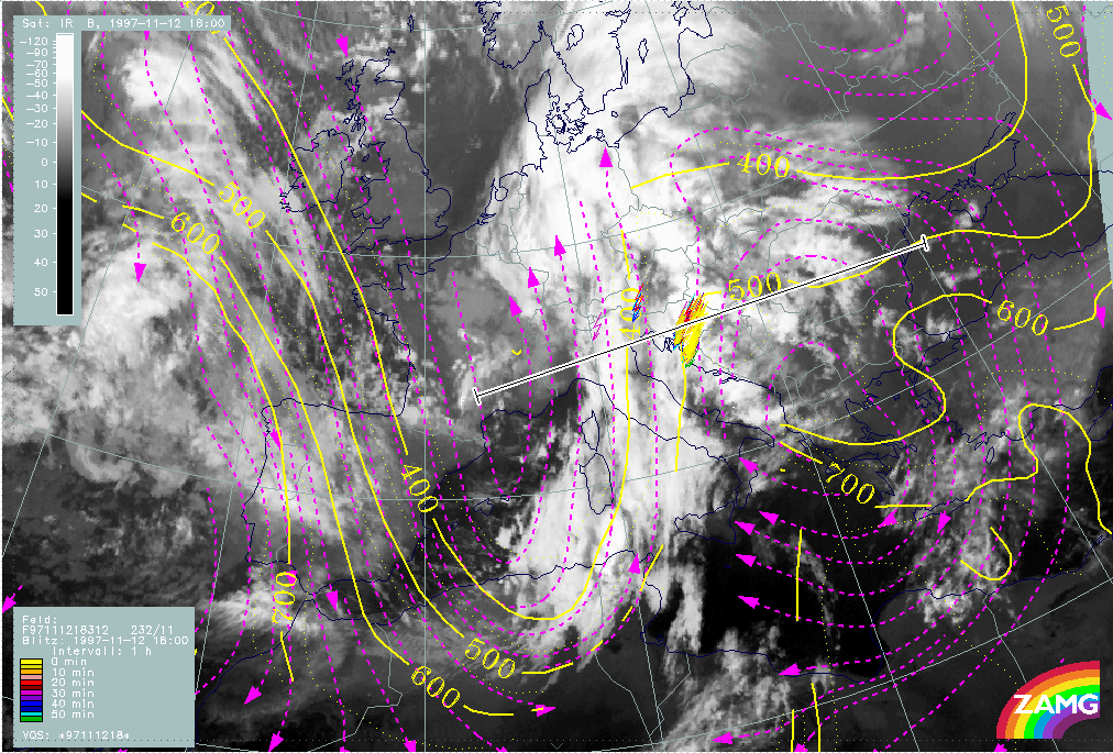
|
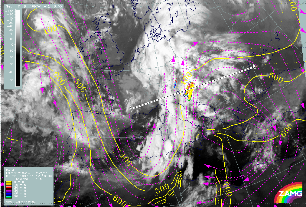
|
The ThetaE surface of 312K (left image) shows in the area of the MCS Th3 a relative stream typical for the Warm Conveyor Belt, while the upper relative stream from behind the front can already be identified over Italy. On the ThetaE surface of 314K (right image) the upper relative stream from behind is shifted more to the east and therefore already within the MCS Th3. This is a vertical distribution of relative streams typical for the leading part of a frontal situation and characteristic for an unstable vertical stratification there.
The period 12 November 21.00 UTC - 13 November 00.00 UTC
Observational part
The last phase of this case study will show further very rapid convective developments at the leading edge of the Cold Front.
|
12 November 1997/21.00 UTC - Meteosat IR enhanced image
|
12 November 1997/21.00 UTC - Meteosat IR image; weather reports (green: rain and showers, blue: drizzle, cyan: snow, purple: freezing
rain, red: thunderstorm with precipitation, orange: hail, black: no actual precipitation or thunderstorm with precipitation)
|
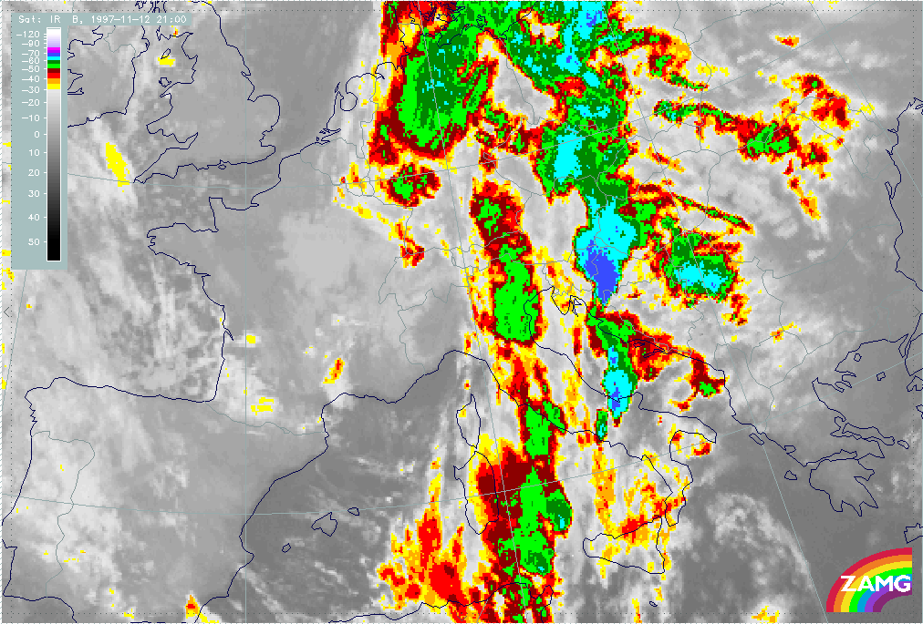
|
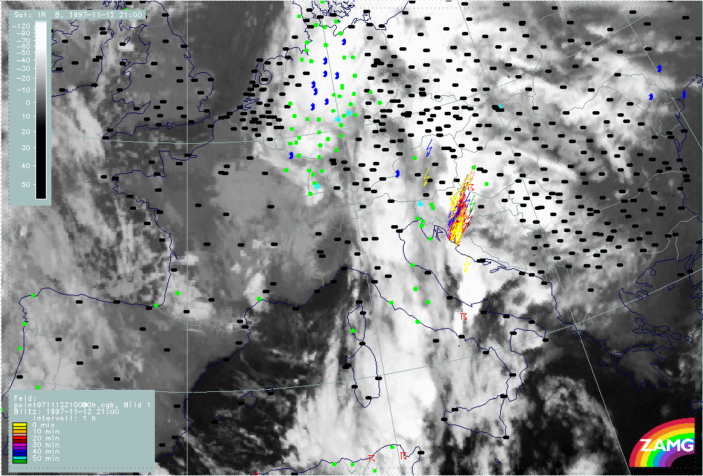
|
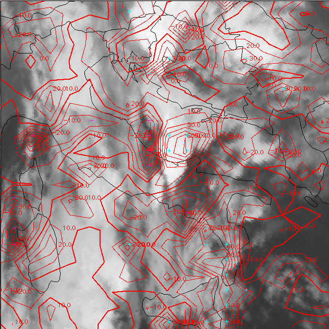
|
|
|
12 November 1997/21.00 UTC - Meteosat IR image; red: mean values of grey shades of cloud development and decay, cyan: cloud development
greater than 30 units, magenta: cloud decay greater than 20 units
|
|
For 21.00 UTC the images show two huge convective systems with very cold tops over, respectively, Croatia (which is the continuation of the former phase Th3) and over central Italy and the Adriatic Sea (the latter has not yet been discussed and is named Th4); two typical oval-shaped cells with cold tops at the upstream edge can be located between Sardinia and Sicily (Th5). The Croatian cell Th3 is still connected with a lot of lightning and thunderstorm reports. Thunderstorms are also observed over Italy within Th4 (right image top). In the upstream edge of the Croatian MCS Th3, exactly where the lightning is reported, new cloudiness is still produced (left image bottom); and also the Italian cell Th4 is an area of strong new development.
|
12 November 1997/22.00 UTC - Meteosat IR enhanced image
|
12 November 1997/22.00 UTC - Meteosat IR image; lightning reports
|
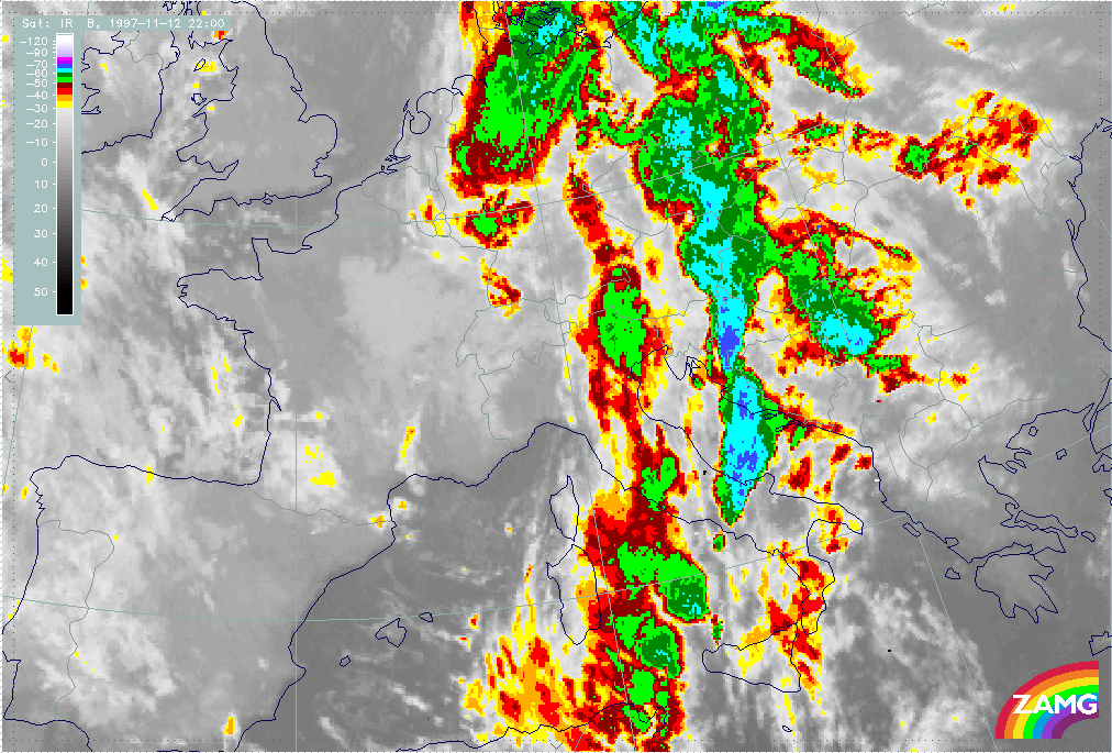
|
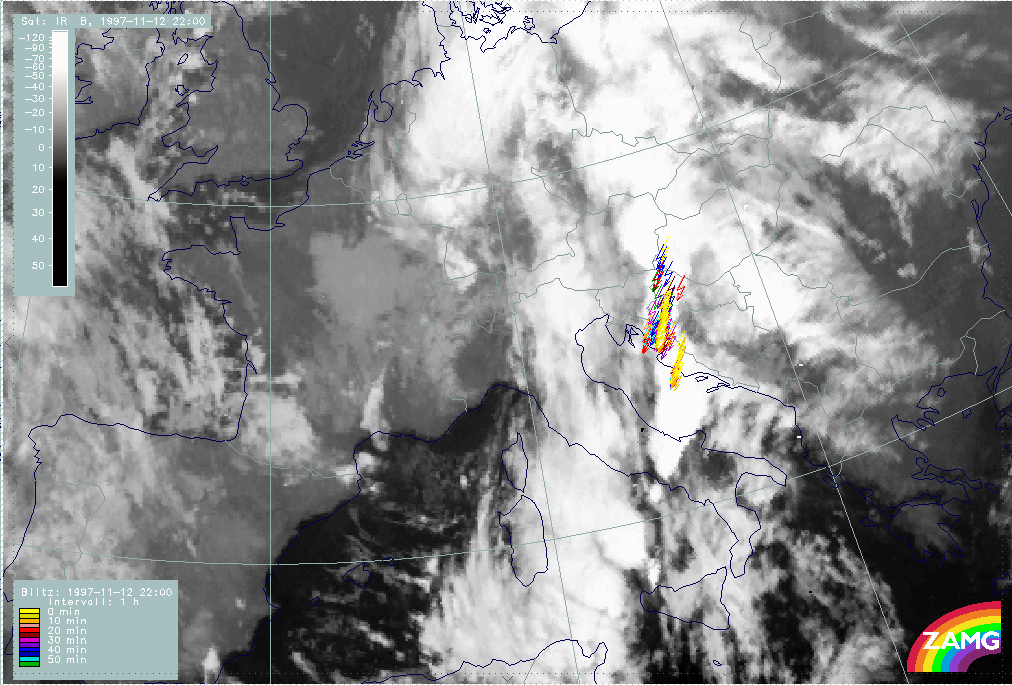
|
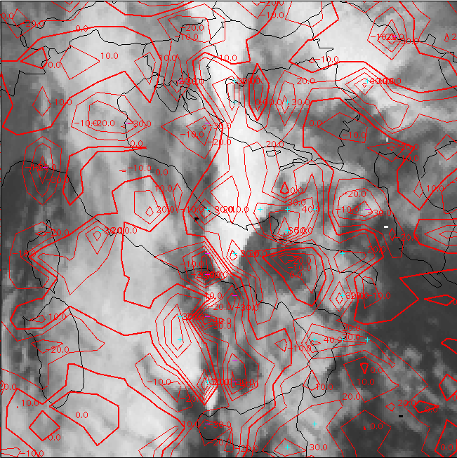
|
|
|
12 November 1997/22.00 UTC - Meteosat IR image; red: mean values of grey shades of cloud development and decay, cyan: cloud development
greater than 30 units, magenta: cloud decay greater than 20 units
|
|
One hour later at 22.00 UTC the situation is as intensive as before; lightning reports have even increased, especially at the Croatian coast in connection with the propagating Italian MCS Th4. There is still a lot of new development connected with the systems Th3 and Th4 (left image bottom) and at this time a lot of new development has also taken place for the new cell north-west of Sicily (Th5).
|
12 November 1997/23.00 UTC - Meteosat IR enhanced image
|
12 November 1997/23.00 UTC - Meteosat IR image; lightning reports
|
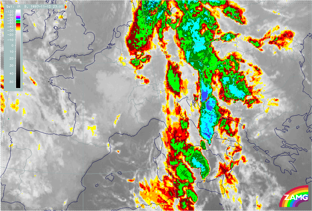
|
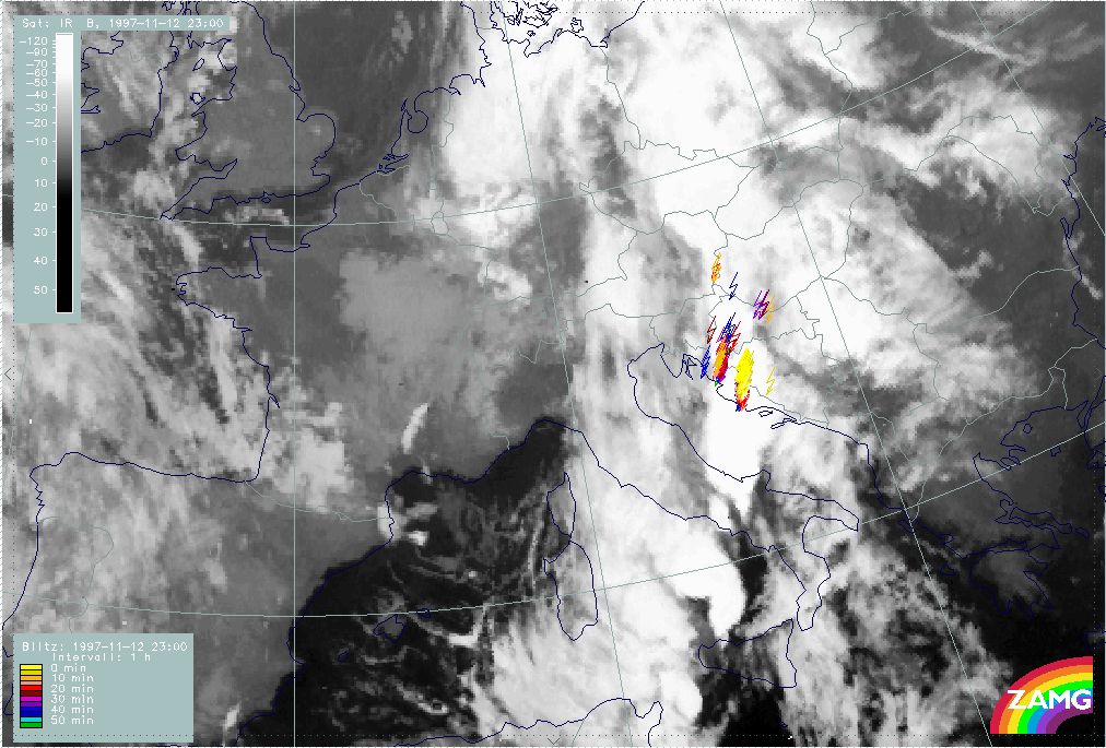
|
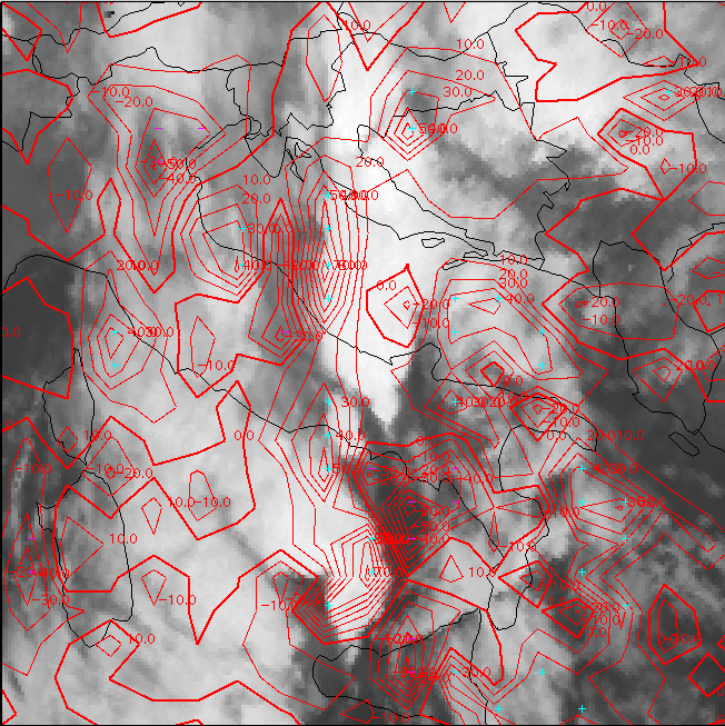
|
|
|
12 November 1997/23.00 UTC - Meteosat IR image; red: mean values of grey shades of cloud development and decay, cyan: cloud development
greater than 30 units, magenta: cloud decay greater than 20 units
|
|
Again one hour later at 23.00 UTC the situation with the two northern convective systems Th3 and Th4 is unchanged with a lot of lightning reports (left and right images top); a notable increase of area and colder cloud tops can be noticed with the system moving north of Sicily towards to the Italian west coast (Th5). The development image (left image bottom) shows notable new cloud development there. Looking at the sequence of images during the next hours it can be seen that this MCS approaches northward and reaches the Croatian coast and Bosnia at 06.00 UTC with widespread lightning reports (left and right images below).
|
13 November 1997/06.00 UTC - Meteosat IR image; lightning reports
|
13 November 1997/06.00 UTC - Meteosat IR image; lightning reports
|
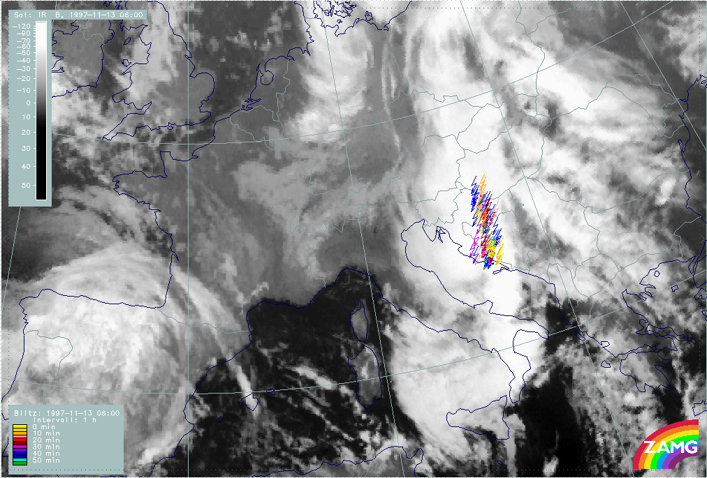
|
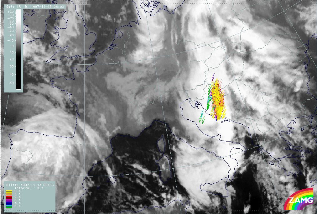
|
Synoptic environment part
|
13 November 1997/00.00 UTC - Meteosat IR image; weather reports (green: rain and showers, blue: drizzle, cyan: snow, purple: freezing
rain, red: thunderstorm with precipitation, orange: hail, black: no actual precipitation or thunderstorm with precipitation); position
of vertical cross sections indicated
|
|
|
|
The image above shows the cloud situation at 13 November 00.00 UTC: the two convective systems Th3 and Th4 over Croatia, Bosnia and the Adriatic Sea have merged and are accompanied by a lot of lightning measurements and thunderstorm reports. Between the Italian south-west coast and north Sicily the MCS Th5a has increased; this cloud formation will reach Croatia and Bosnia six hours later. A smaller but well-shaped MCS can be seen close to west Sicily (Th5b). Three vertical cross sections illustrate the situation with the different MCSs and will be discussed later. It can be noticed that all MCSs are in one line from south-south-west to north-north-east and at the leading edge of the Cold Front cloud band. This can be supported by the relevant numerical parameters.
|
13 November 1997/00.00 UTC - Meteosat IR image; cyan: Showalter index 500/850 hPa, lightning reports; position of vertical cross
section indicated
|
13 November 1997/00.00 UTC - Meteosat IR image; blue: thermal front parameter (TFP) 500/850 hPa, red: temperature advection 1000 hPa,
lightning reports
|
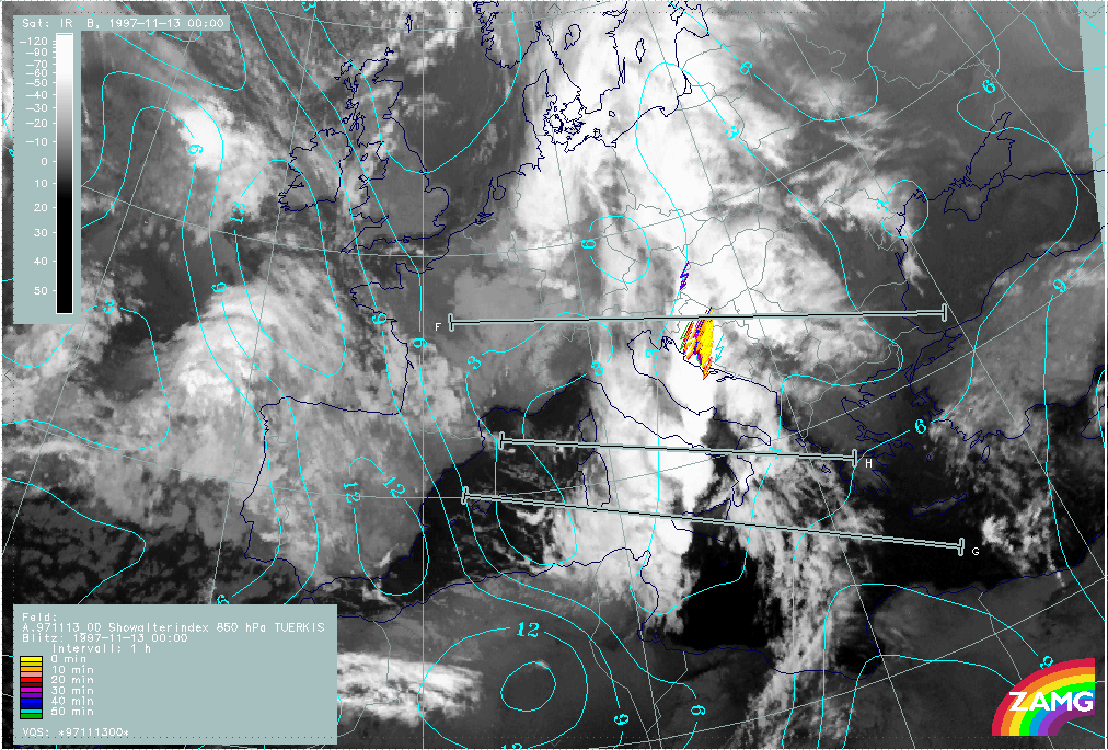
|
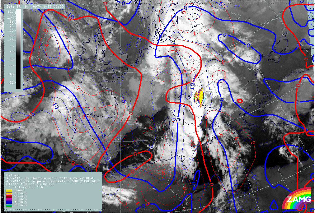
|
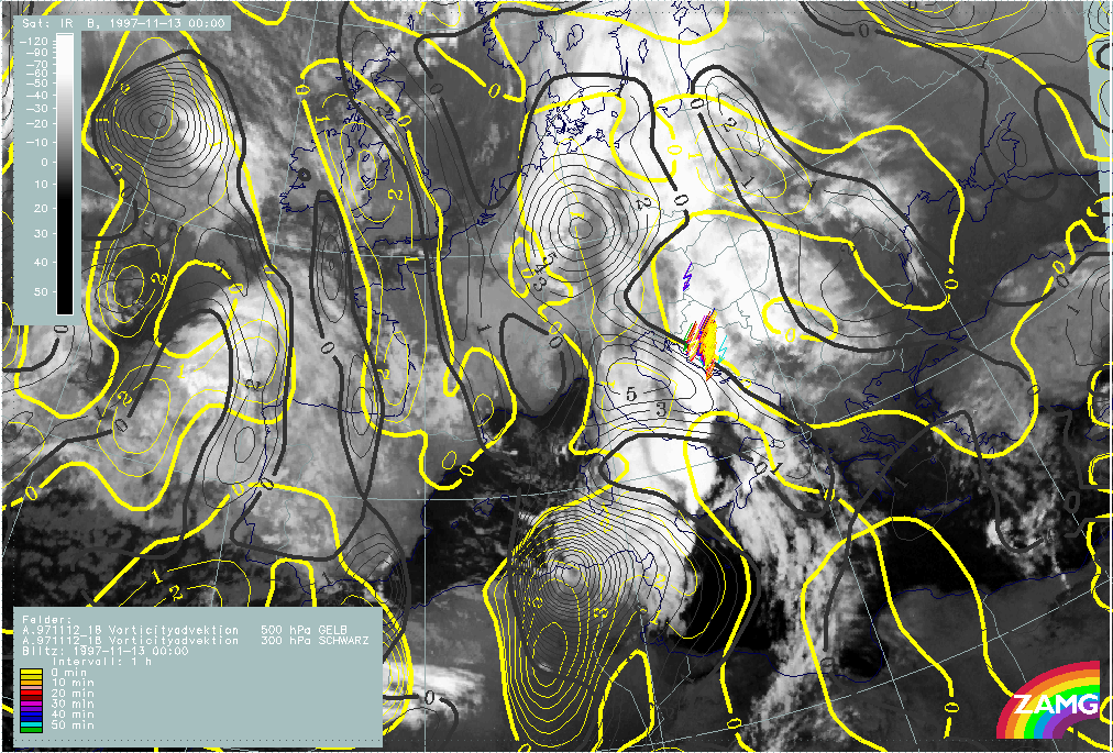
|
|
|
13 November 1997/00.00 UTC - Meteosat IR image; yellow: positive vorticity advection (PVA) 500 hPa, black: positive vorticity advection
(PVA) 300 hPa, lightning reports
|
|
As the Showalter index indicates (left image top), there is a high probability of thunderstorms in this leading part of the cloud front band; the area with Showalter index <3 units is now, for the first time during the discussion period, smaller and more directly related to this part of the cloud band. All the cells and cell complexes are very close to the TFP line and, with the exception of the southernmost cell west of Sicily (Th5b), all are close to the transition between WA and CA (right image top). The latter mentioned cell Th5b is under the influence of CA and, contrary to the other cells, in direct connection with PVA maxima aloft (left image bottom).
These differences can also be noticed in the vertical cross sections. The northern vertical cross section R through the Croatian MCS Th3 + Th4 is compared to the southern cross section S across the smaller convective system Th5b west of the WA area.
|
13 November 1997/00.00 UTC - Meteosat IR image; position of vertical cross sections S and R indicated
|
13 November 1997/00.00 UTC - Vertical cross section R; black: isentropes (ThetaE), red thin: temperature advection - CA, red thick:
temperature advection - WA, orange thin: IR pixel values, orange thick: WV pixel values
|
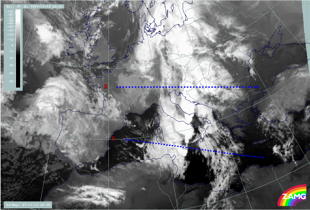
|
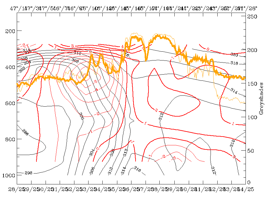
|
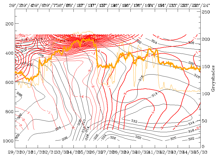
|
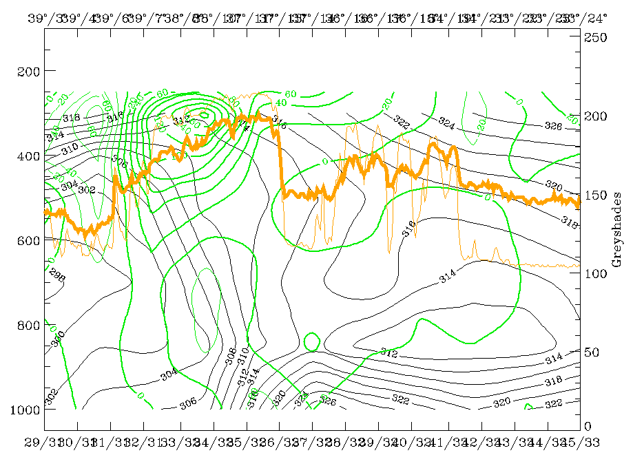
|
|
13 November 1997/00.00 UTC - Vertical cross section S; black: isentropes (ThetaE), red thin: temperature advection - CA, red thick:
temperature advection - WA, orange thin: IR pixel values, orange thick: WV pixel values
|
13 November 1997/00.00 UTC - Vertical cross section S; black: isentropes (ThetaE), green thick: vorticity advection - PVA, green thin:
vorticity advection - NVA, orange thin: IR pixel values, orange thick: WV pixel values
|
The left and right top images show isentropes and temperature advection. Both convective systems can be identified by the maximum in the satellite signals and by the thunderstorm report. In both cross sections the frontal zones can be discriminated easily and the thunderstorms appear with the frontal zone. But the northern frontal zone has a much deeper layer with superadiabatic inclination than the southern one. Besides this the WA in the lower layer is only involved in the northern cross section, while the thunderstorm in the southern one occurs in an area of CA reaching into high levels. This latter fact is compensated for by an increase of PVA with height as can be seen in the bottom left image.
|
13 November 1997/00.00 UTC - Vertical cross section R; black: isentropes (ThetaE), magenta thin: divergence, magenta thick:
convergence, orange thin: IR pixel values, orange thick: WV pixel values
|
13 November 1997/00.00 UTC - Vertical cross section S; black: isentropes (ThetaE), magenta thin: divergence, magenta thick:
convergence, orange thin: IR pixel values, orange thick: WV pixel values
|
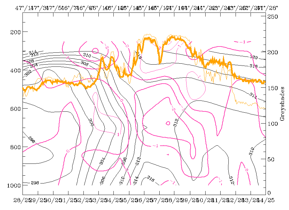
|
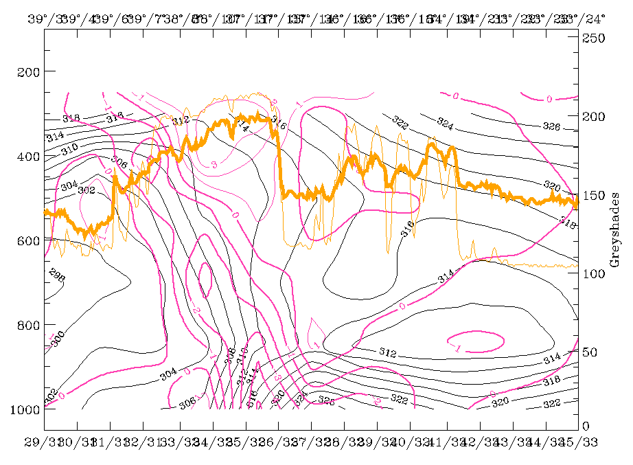
|
The images above finally show that in both cases there is a layer of notable convergence but again there are differences between the two cases. For the northern MCS maximal convergence exists in the middle troposphere ahead of the front, while for the southern cell it is the convergence cell within the front which causes high convergence in the lower and middle layers.
|
13 November 1997/00.00 UTC - Vertical cross section R; black: isentropes (ThetaE), orange thin: IR pixel values, orange thick: WV pixel
values
|
13 November 1997/00.00 UTC - Vertical cross section S; black: isentropes (ThetaE), orange thin: IR pixel values, orange thick: WV pixel
values
|
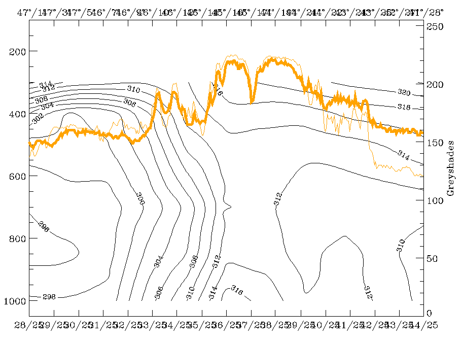
|
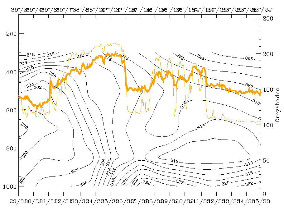
|
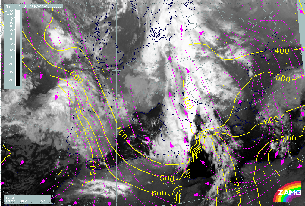
|
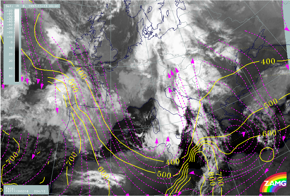
|
|
13 November 1997/00.00 UTC - Meteosat IR image; magenta: relative streams 314K - system velocity 237° 12 m/s, yellow: isobars
|
13 November 1997/00.00 UTC - Meteosat IR image; magenta: relative streams 316K - system velocity 234° 12 m/s, yellow: isobars
|
Finally, two isentropic surfaces repeat a situation which has already been mentioned in the SatRep diagnosis for this time (compare Synoptic Situation for 13 November 00.00 UTC). On ThetaE 314K (left image) the fast-growing cell between Sicily and Italy coincides with a Warm Conveyor Belt. On ThetaE 316K (right image) it is already the drier relative stream from behind. This is not only a typical frontal situation causing lability but might be an explanation in this case for the sudden and fast development of the MCSs in this area. Because of a change in the jet situation between 12/18.00 UTC and 13/00.00 UTC with the development of a new jet streak over Tunisia and further eastward, the relative streams from behind the front moved into the area ahead of the frontal cloud band.
Some summarizing ideas
The approach for an identification and forecast of convective and thunderstorm activity is twofold:
- The identification and nowcast
- The definition of conceptual models for the environment of the convective developments.
One important diagnosis tool for convective events is not included in the material, namely radar. In this connection the question arises whether satellite observations have any advantages for convective developments compared to radar information.
The examples in the four periods clearly show that the advantage of satellite imagery is its larger coverage area. Three of the cells which influenced the Balkan Peninsula, especially Croatia and Bosnia and to a lesser extent also Slovenia, developed from very small cells over the Italian west coast and even more to the west. Therefore it is easy to detect and follow these features first in the satellite imagery and then to supplement weather and sferics observations. The development images allow a good possibility for an early detection of new cloudiness and for the differentiation of the life cycle. But there are also limitations, and new methods like object detection seem to be necessary.
As could be shown in several examples, nowcast methods are for the time being an adequate tool for an MCS forecast.
The use of conceptual models for the environment of convective developments indicates typical features in relevant parameters fields, especially in vertical cross section fields. In this case study superadiabatic layers have been the most important feature in common, but also the vertical extension and variation of TA with WA as a key parameter and convergence in a thick layer were recognized in all cases. All MCSs which developed at the leading edge of the frontal surface showed the classical distribution of conveyor belts, with a Warm Conveyor Belt below and a much cooler and drier relative stream from behind the front above; in this case such an effect was intensified by a jet streak crossing the front and by the transportion of dry air at higher levels on the leading part of the front.