Stability indices
There are many different indices to indicate potential for deep convection. They treat instability in different ways or focus on the instability of different layers; while the K- and Showalter indices describe mid-tropospheric instability, the lifted index contains information about instability in a deeper layer reaching from the near surface to mid-levels. (For more on their definitions, see Chapter II and the analyses in Sections K-index and Lifted and Showalter indices) The indices are used according to their history of usefulness in given regions and weather situations.
The instability parameters are based both on temperature and moisture profiles. The SPhR can slightly correct the NWP forecasted moisture profile, but it makes almost no modification to the temperature profile, as the SEVIRI IR channels do not carry the necessary information. So the modification of the instability indices (compared to the NWP forecasted one) is performed practically through the moisture profile. The SPhR algorithm derives three types of instability index: the K-, lifted and Showalter indices.
K-index
This is a rather simple index containing temperature information of three layers and moisture information of two layers. The definition is explained in Section 2, or in the 'Global Instability Index' EUMeTrain webcast ( http://www.eumetrain.org/resources/global_instability_index_2011.html).
As it is calculated from 850, 700 and 500 hPa level parameters, this index does not contain information about surface or near-surface conditions, and consequently has almost no daily cycle. The K-index describes the mid-layer moisture and stability properties inside an air mass in a very simple way and may miss local or low-level details.
The satellite-derived K-index is most suitable for thunderstorms within warm, moist air masses in the summer. As the K-index has no daily cycle, it can provide information about mid-tropospheric instability in the morning, before convection commences and convective clouds develop, and may foreshadow afternoon showers provided there is enough moisture and no advection.
K-index can be used as a "first guess" to separate stable areas from unstable ones. Usually, the K-index is below 20 °C in a stable environment and above 20 °C in unstable conditions. Below we present three examples to demonstrate this.
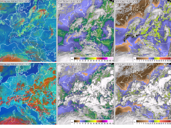
The first example is from 21 May 2011. Fig. 9 shows the situation at 06:10 (top row) and 15:10 UTC (bottom row). The Day Microphysics RGB images in the left panels show the convective clouds. The middle panels show the SPhR TPW values. The right panels show the SPhR K-index: brownish colors stand for K-index less than 20 °C. No thunderstorms developed in these areas.
Figure 9: Meteosat SEVIRI images and products from 21 May 2011 at 06:10 (top row) and 15:10 UTC (bottom row): Day Microphysics RGB image (left column), SPhR TPW (middle column), SPhR K-Index (right column).
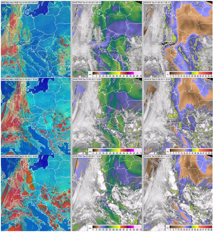
The second example is from 31 May 2011. Fig. 10 shows the situation at 06:10 (top row), 10:55 (middle row) and 14:25 UTC (bottom row). The right panels show the SPhR K-Index, brownish colors standing for K-index less than 20 °C. No thunderstorms developed in these areas.
Figure 10: Meteosat SEVIRI images and products from 31 May 2011, 06:10 (top row), 10:55 (middle row) and 14:25 UTC (bottom row): Day Microphysics RGB image (left column), SPhR TPW (middle column) and SPhR K-Index (right column).
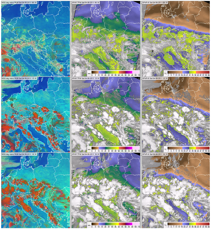
The third example is from 4 June 2011. Fig. 11 shows the situation at 06:10 (upper row), 13:10 (middle row) and 16:10 UTC (bottom row). The right panels show the SPhR K-index, brownish colors standing for K-index less than 20 °C. No thunderstorms developed in these areas. The development of the convection is easy to see in the animation showing the same 3 panels between 5:10-16:25 UTC.
In some areas, such as over Poland, the moisture content was quite high (around 23 mm), but no convection formed; the K-index was only 15 °C, which goes to show that a high moisture content alone does not trigger deep convection. Even the combination of high moisture and instability is not sufficient. No convective clouds developed over the Adriatic Sea despite the fact that both TPW and K-index values were high (29 mm and 28 °C, respectively). This demonstrates the effects of missing lifting, the presence of a local inversion or a shallow stable layer, all of which inhibit convection.
Figure 11: Meteosat SEVIRI images and products from 4 June 2011, 06:10 (top row), 13:10 (middle row) and 16:10 UTC (bottom row): Day Microphysics RGB image (left column), SPhR TPW (middle column) and SPhR K-Index (right column). Press the orange play button to see the animation.
Note that for areas where surface pressure is less than 850 hPa, the K-index is not defined, so in high mountains it cannot be used to separate stable areas from unstable ones.
Lifted and Showalter indices
The lifted and Showalter indices are defined as the difference between the air temperature at 500 hPa and the temperature of an air parcel lifted adiabatically up to 500 hPa from the lower levels. The indices have negative values when the lifted parcel is warmer than the environment, which is an indicator of instability and possible convection. The difference between the two indices is the starting level where the virtual air parcel is lifted from. In the case of the lifted index, the parcel is lifted from near the surface (the lowest layer that is 100 hPa deep), while in the Showalter index it is lifted from 850 hPa.
The Showalter index only provides information on mid-tropospheric instability, while the lifted index also reflects near-surface heating. High negative values indicate greater instability for both indices, but one can never rely solely on them to evaluate convective potential.
The lifted index contains information about the near-surface layers, which means it has a daily cycle and can reflect some of the effects of topography on convection. For example, nocturnal cooling is usually stronger in lowlands than higher up, whereas later during the day, the convection is more intense at lowlands due to higher temperature and moisture.
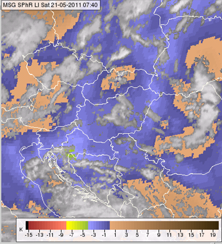
The following example demonstrates that lifted index values depend on topography (Fig. 12). The locations of higher mountains (e.g. Carpathians) are clearly seen in the lifted index image (LI is higher in mountains due to lower temperature). However, LI does not reflect the influence of nocturnal circulation in mountainous areas caused by the flow of cold air down the slopes, resulting in higher pressure, or other dynamic effects, which can trigger convection in mountainous areas even when the properties of the parcel lifted from near the surface do not seem favorable for convection. The exact description of near-surface temperature and moisture properties in mountain areas (e.g. effects of valleys, etc.) would also require very high horizontal resolution (1 km or less), which is not yet available for SPhR products or input NWP models.
Figure 12 SPhR Lifted Index from 21 May 2011, 07:40 UTC
The definition of K-, lifted and Showalter indices and the way to calculate them are different although they all are supposed to characterize instability and potential for convection. As they provide different information they all should be taken into consideration at the same time, along with many other parameters.
The cases presented next will focus on the similarities and differences between the SPhR indices.
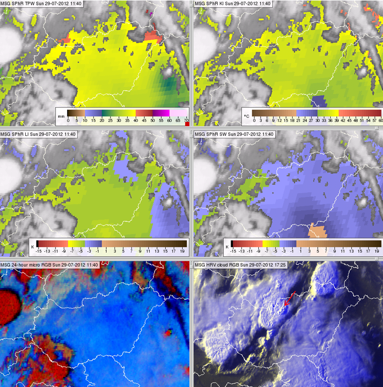
The first is a case where all SPhR parameters indicated high instability (K-index around 36 °C, lifted index around -4.6 K, and Showalter index around -3.6 K) as well as much moisture (TPW around 37 mm, Fig. 13). That evening very severe weather occurred close to the city of Vác. Its location is indicated by the red arrow in the lower right panel. Note that the time signature of the bottom left panel is different from the others. The bottom left panel depicts the storm in its mature stage at 17:25 UTC, while the other panels show the pre-convective environment at 11:40 UTC, when the area was mostly cloud-free and severe convection had not yet initiated.
Figure 13 Meteosat SEVIRI images and products from 29 July 2012, 11:40 UTC, except the lower right panel, which is from 17:25 UTC: satellite-retrieved TPW (top left), K-Index (top right), Lifted Index (middle left), Showalter Index (middle right), 24 hour Microphysics RGB image (bottom left) and HRV cloud RGB image (bottom right).
While in the previous example we presented a high instability case, in the following examples we will discuss the ability of these indices to distinguish stable and unstable areas. While covering the K-index, we stated that 20 °C is a good dividing threshold. According to Table 1 in Chapter II the corresponding threshold value for the lifted index is 0 °C. Do these thresholds give us similar results, at least approximately? In the standard color scales, negative lifted index values and K-index values less than 20 °C are brownish, indicating a stable environment.
Sometimes the 0 °C lifted index boundary matches the 20 °C K-index boundary (Fig. 14). However, sometimes it falls closer to the 30 °C K-index boundary (Fig. 15). We will also present a case where the lifted index shows potential for convection in area, while the K-index indicates a stable mid-layer (Figs. 16 and 17).
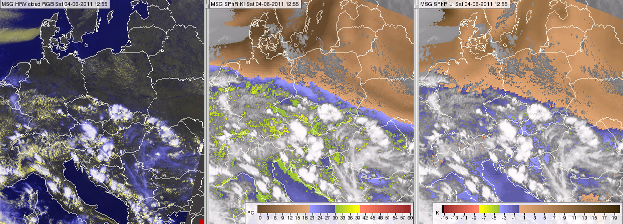
Fig. 14 shows a case where the 20 °C K-index and 0 °C lifted index isolines are close to each other (see the bluish and greenish colors in the middle and right panels). Thunderstorms developed in the area where both indices indicated instability.
Figure 14 Meteosat SEVIRI image and products from 4 June 2011, 12:55 UTC: HRV cloud RGB image (left), satellite-retrieved SPhR K-Index (middle) and Lifted Index (right).
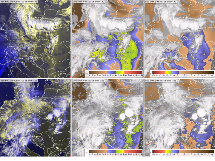
Fig. 15 shows a case when the 20 °C K-index and 0 °C lifted index contours were far from each other. The 0 °C lifted index boundary matches the 30 °C K-index isoline better than the 20 °C isoline. Thunderstorms developed in the area where the lifted index was negative and the K-index higher than 30 °C.
Figure 15: Meteosat SEVIRI images and products from 3 August 2013, 04:40 (top) and 12:55 UTC (bottom): HRV cloud RGB images (left), satellite-retrieved SPhR K-Index (middle) and Lifted Index (right).
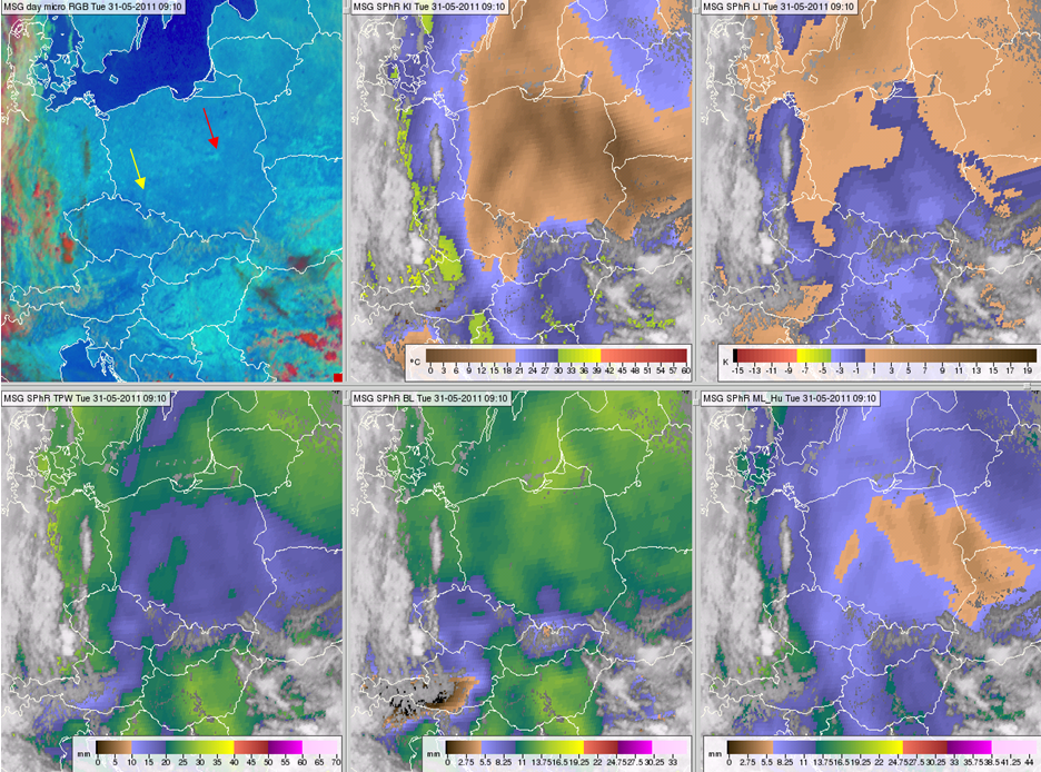
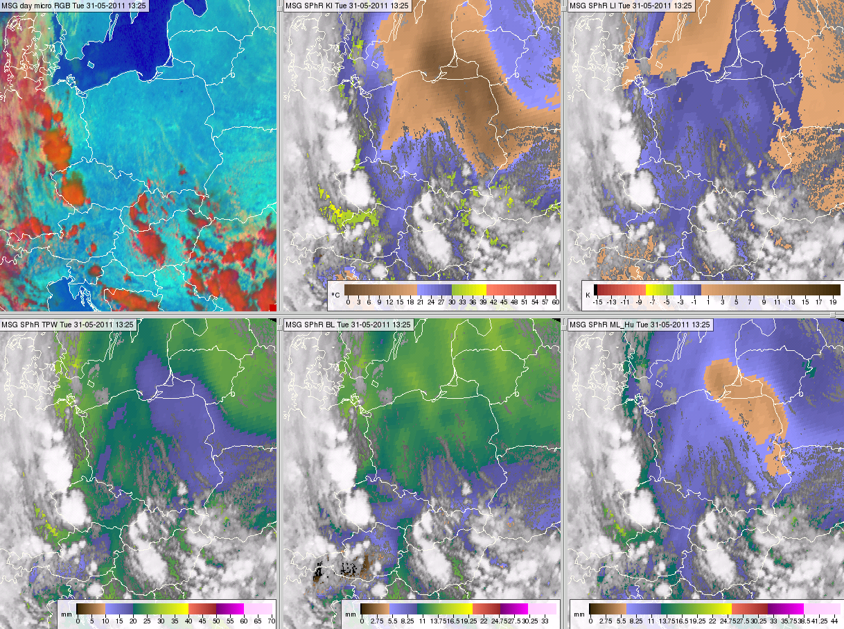
The next example presents a case where the lifted index was negative, which indicates conditions favorable for convection, while the K-index values (below 20 °C) suggested the opposite. The situation is shown in Fig. 16 at 09:10 UTC and in Fig. 17 at 13:25 UTC. According to the K-index, the troposphere's middle layers were stable above Poland at 09:10 UTC (except for the mountainous region in the far south), while the lifted index indicated instability over the southern half of the country. At 13:25 UTC the K-index indicated slight instability over a third of the country and very stable stratification above the northeast region. In contrast, the lifted index was negative throughout most of the country, including the northeastern part, where it had a local minimum (down to around -1.9 °C). RGB images show that there was no convection over Poland that day, except over the High Tatra Mountains in the south.
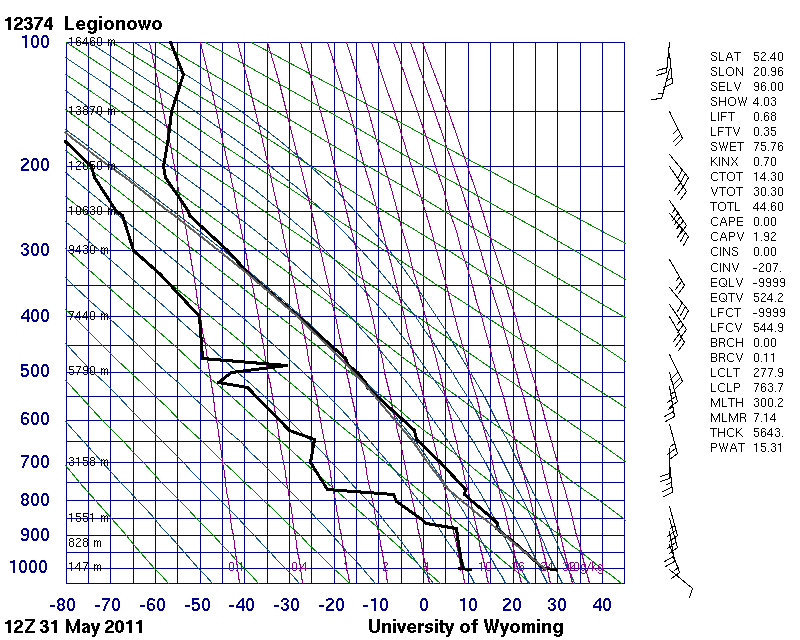
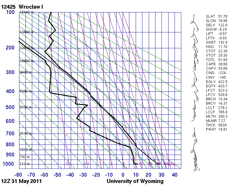
To explain this 'contradiction' we visualized the SPhR TPW, BL and ML (see the bottom rows of Figs. 16 and 17). The BL had moderate to high amounts of moisture, but the ML was very dry. K-index values were low because the 700 hPa dew point depression was high. (We also checked it in radiosonde sounding measurements: Fig. 18 shows sounding data at two Polish stations. Their locations are indicated in Fig. 16). However, the definition of the lifted index does not include any information from around 700 hPa, only the near-surface environment and around 500 hPa. The lifted index values seemed to have been unaffected by the very dry mid-layer. Lifted index calculations are based on the adiabatic lifting of a virtual air parcel up to 500 hPa. However, in reality the lifting is not adiabatic in such a dry environment, and some mixing with the environment is inevitable.
These examples demonstrate how the different indices depict different situations. In cases where the indices indicate different conditions, the forecaster should keep in mind the reasons behind those differences and consider all relevant parameters and profiles of soundings or NWP data.
Figure 16 Meteosat SEVIRI image and products from 31 May 2011, 09:10 UTC: Day Microphysics RGB (top left), satellite-retrieved K-Index (top middle), Lifted Index (top right), TPW (bottom left), BL (bottom middle) and ML (bottom right). The yellow and red arrows indicate the locations of Wraclaw and Legionowo radiosonde stations, respectively. The corresponding soundings are presented in Fig. 18.
Figure 17 Meteosat SEVIRI image and products from 31 May 2011, 13:25 UTC: Day Microphysics RGB (top left), satellite-retrieved K-Index (top middle), Lifted Index (top right), TPW (bottom left), BL (bottom middle) and ML (bottom right)
|
|
Figure 18: Radiosonde data measured at 31 May 2011, 12 UTC in Legionowo and Wroclaw, Poland. The locations of the stations are indicated in Fig. 16.
Next, let us concentrate on convection over mountainous areas. We have found slightly positive lifted index values in cases where convective clouds developed over mountainous terrain. How is it possible, when positive lifted index is supposed to indicate stability in the environment?
- The lifted index may be actually positive. Weak convection is possible for lifted index values 1-3 °C if strong lifting is present. The lifting may be the result of strong winds in the mountains, for example.
- The thunderstorm might originate from a valley (below the mean height of the bottom 100 hPa layer, which is used in calculating the lifted index)
- The mountains may lift the parcel above the "lower 100 hPa layer" where (the stratification of) the atmosphere may be more unstable.
- Positive values of the lifted index might not reflect the true conditions over complex orography due to insufficient resolution or errors in NWP data. Lifted index values are less reliable over mountainous regions. Errors in LI values are mostly due to differences between the real topography and the topography used in NWP model and in the satellite retrieval. The lifted index is usually closer to zero over mountains since the virtual air parcel is lifted from a pressure level closer to 500 hPa, which means its temperature is usually closer to the 500 hPa environmental temperature. Also, its relative humidity is lower, as there is less moisture in the mountains.
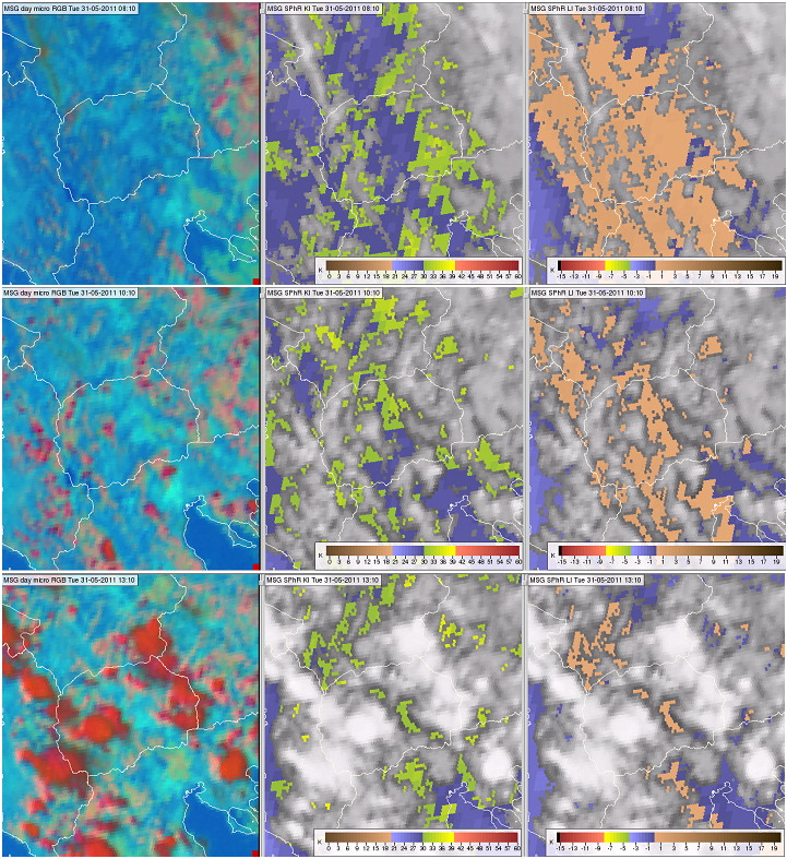
The following example presents a case where thunderstorms formed over mountains and the lifted index was positive. Fig. 19 shows Macedonia on 31 May 2011. Macedonian topography is rugged, with many hills and mountains. The K-index was around 30 °C that day, while the lifted index was slightly positive (between 1.1 and -0.2 K). The Showalter index (not shown in the figure) was between 1.5 and 0.8 K. The K-index showed an unstable mid-layer, while the lifted and Showalter indices indicated no or low potential for deep convection. As can be seen in the 10:10 and 13:10 UTC images, thunderstorms formed over these mountains during the day.
Figure 19: Meteosat SEVIRI images and products from 31 May 2011 at 08:10 (top row), 10:10 (middle row) and 13:10 UTC (bottom row): Day Microphysics RGB (left panels), satellite-retrieved K-Index (middle panels) and Lifted Index (right panels).
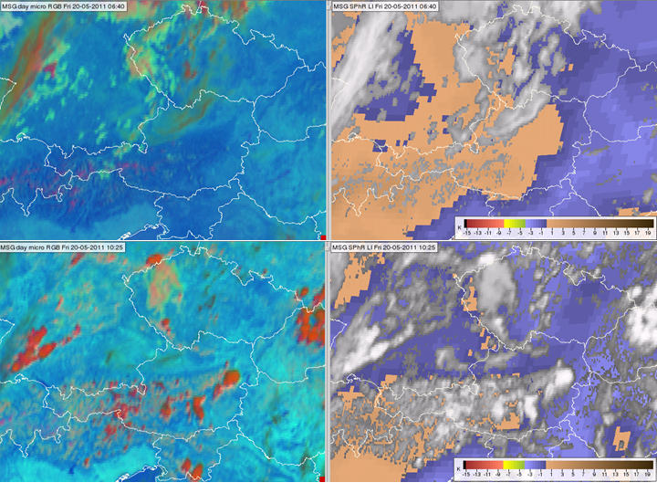
Because the K- and Showalter indices are undefined in high mountains where the surface pressure is less than 850 hPa, the lifted index is the only one that can be used with SPhR. Fig. 20 shows such a situation. For most of the Alps the K-index is undefined while the lifted index is slightly positive (around +0.4 K). Thunderstorms developed in this case.
Figure 20 Meteosat SEVIRI images and products from 20 May 2011 at 06:40 (top row) and 10:25 UTC (bottom row): Day Microphysics RGB (left panels), satellite-retrieved Lifted Index (right panels).
