Examples of the output – (18 August 2011)
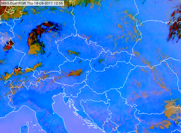
This section presents examples of the outputs. A Dust RGB shows an overview of the situation:
Figure 1: Meteosat SEVIRI Dust RGB from 18 August 2011, 12:55 UTC.
The Dust RGB has visual information on low-level moisture: cloud-free areas with more moisture appear in darker blue than dryer regions. Note that the color also depends on temperature and surface emissivity, so the RGB's hues vary according to the situation.
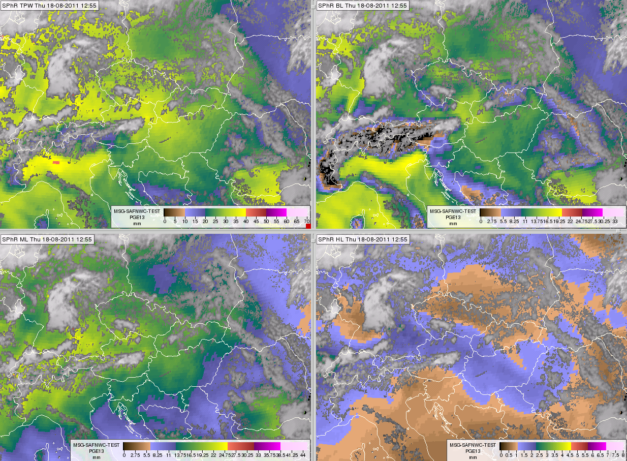
Fig. 1 shows a relatively dry patch over central Poland and high moisture content over the Po Valley in northern Italy. The same pattern can be seen in the SPhR outputs. Fig. 2 shows the TPW, BL, ML and HL products. Central Poland is relatively dry and the Po Valley is relatively moist in the TPW, BL and ML images.
In SPhR outputs the gray shades, attained from the IR10.8 µm channel, correspond to cloudy areas. Colors correspond to the cloud-free area and show the SPhR results. Note that the same color scales are used for TPW, BL, ML and HL, but with different ranges (see Table 4). These are the ‘standard’ color scales and ranges used by the developers on the NWCSAF website.
Topography features clearly in the BL image. The black color over the Alps indicates high terrain, where BL cannot be retrieved.
Figure 2: SPhR results from 18 August 2011, 12:55 UTC: Total Precipitable Water (TPW, top left), Boundary Layer Precipitable Water (BL, top right), Mid-Layer Precipitable Water (ML, bottom left) and High-Layer Precipitable Water (HL, bottom right).
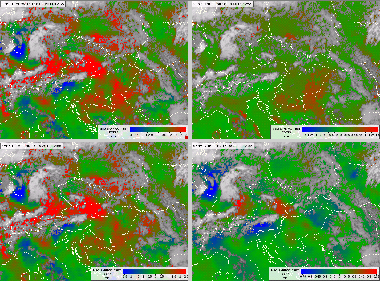
Fig. 3 shows the differences between the satellite-retrieved and ECMWF forecasted TPW, BL, ML and HL. Again the grays correspond to cloudy areas and show the IR10.8 data. The colors correspond to cloud-free areas and show the SPhR results. Note that the same color scales are used for DiffTPW, DiffBL, DiffML and DiffHL, but with different ranges (see Table 4). These are the ‘standard’ color scales and ranges used by the developers on the NWCSAF website. Reddish colors mean that the SPhR algorithm retrieved higher values than forecasted by ECMWF, while bluish colors mean the opposite: the SPhR algorithm retrieved lower values than forecasted by ECMWF.
Figure 3: SPhR results from 18 August 2011, 12:55 UTC: differences between the satellite-retrieved and NWP forecasted Total Precipitable Water (DiffTPW, top left), Boundary Layer Precipitable Water (DiffBL, top right), Mid-Layer Precipitable Water (DiffML, bottom left) and High-Layer Precipitable Water (DiffHL, bottom right)
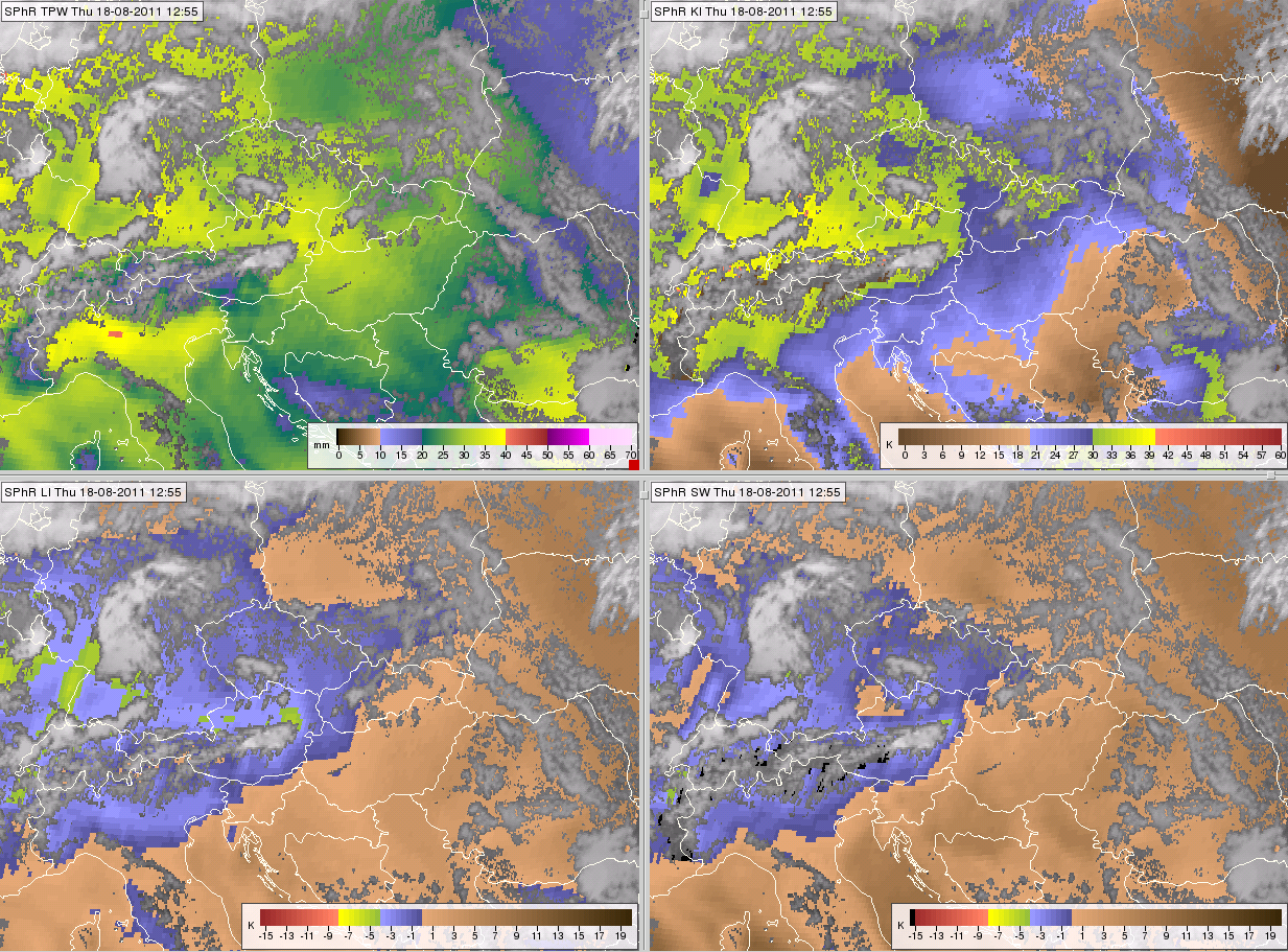
Fig. 4 shows the TPW and the instability indices: K-, lifted and Showalter indices. Again the grayscale corresponds to cloudy areas and shows the IR10.8 data. The colors correspond to cloud-free areas and show the SPhR results. The same color scales are used for the lifted and the Showalter indices. The ranges are listed in Table 4. These are the ‘standard’ color scales and ranges used by the developers on the NWCSAF website. Brownish colors correspond to a stable environment (stable mid-layer in the case of K- and Showalter indices and stable ‘near-surface to 500 hPa’ layer in the case of the lifted index), while shades of blue to yellow to red denote increasing instability and potential for convection.
Figure 4: SPhR results from 18 August 2011, 12:55 UTC: Total Precipitable Water (TPW, top left), K-Index (KI, top right), Lifted Index (LI, bottom left) and Showalter Index (SW, bottom right)
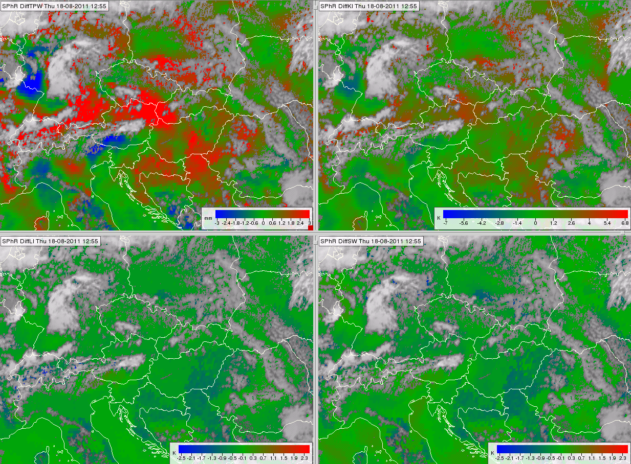
Fig. 5 shows the differences between the satellite-retrieved and ECMWF forecasted TPW, K-, lifted and Showalter indices. Again the grayscale corresponds to cloudy areas and shows the IR10.8 data. The colors correspond to cloud-free areas and show the SPhR results. Note that the same color scales are used for DiffTPW, DiffKI, DiffLI and DiffSW, but with different ranges (see Table 4). These are the ‘standard’ color scales and ranges used by the developers on the NWCSAF website.
Reddish colors mean that the SPhR algorithm retrieved values higher than forecasted by ECMWF, while bluish colors mean the opposite: the SPhR algorithm retrieved values lower than forecasted. An environment favorable for deep convection usually has high K-index and a low lifted and Showalter indices, DiffLI and DIffSW tend to be blue in areas where DIFFKI is red and vice versa.
Figure 5: SPhR results from 18 August 2011, 12:55 UTC: differences between the satellite-retrieved and the NWP forecasted Total Precipitable Water (TPW, top left), K-Index (KI, top right), Lifted Index (LI, bottom left) and Showalter Index (SW, bottom right)
| Min value/[mm] | Max value/[mm] | Min value/[mm] | Max value/[mm] | ||
|---|---|---|---|---|---|
| TPW | 0 | 70 | DiffTPW | -3 | 3 |
| BL | 0 | 35 | DiffBL | -1.5 | 1.5 |
| ML | 0 | 45 | DiffML | -2.5 | 2.5 |
| HL | 0 | 8 | DiffHL | -0.75 | 0.75 |
| Min value/[°C] | Max value/[°C] | Min value/[°C] | Max value/[°C] | ||
| KI | 0 | 60(unstable) | DiffKI | -7 | 7 |
| LI | -15(unstable) | 25 | DiffLI | -2.5 | 2.5 |
| SHW | -15(unstable) | 25 | DiffSHW | -2.5 | 2.5 |
Table 4: Ranges of the color scales used by the developers
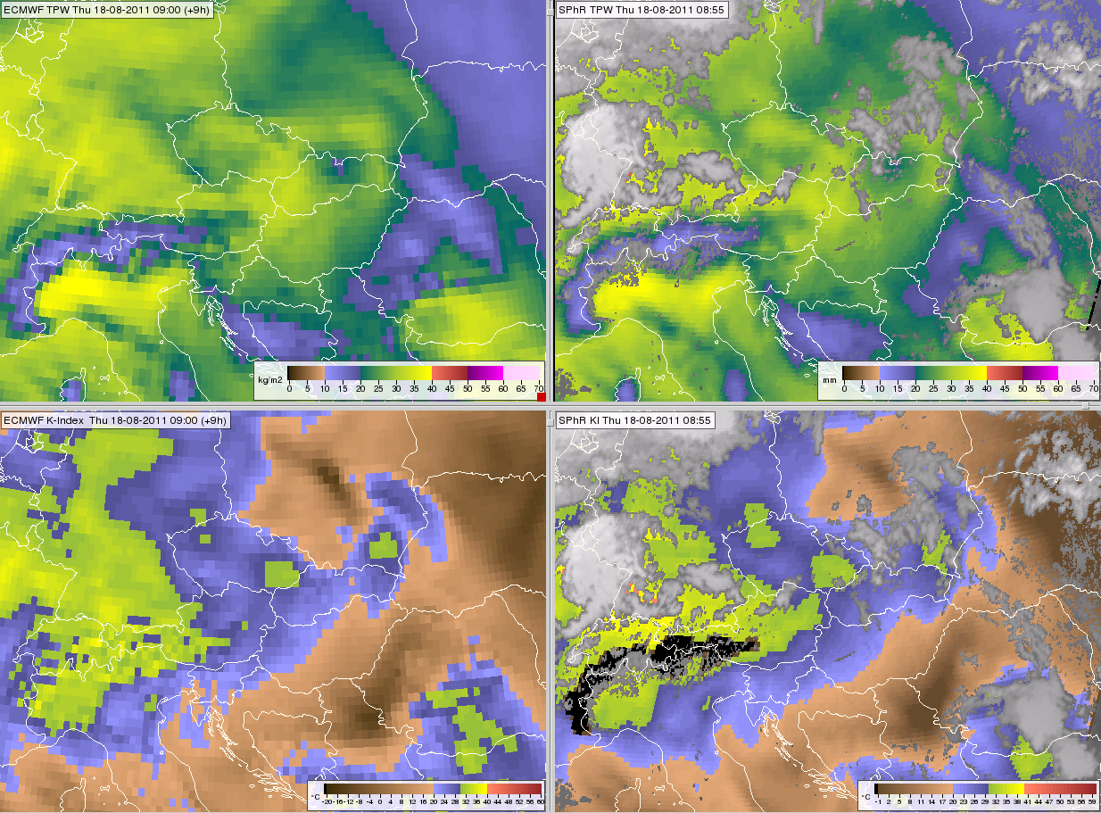
To compare the main features of numerically forecasted and satellite-retrieved parameters, an animation was created from the time series of ECMWF forecasted and satellite-retrieved K-index and TPW between 04:10-18:10 UTC. Fig. 6 shows the parameters at 09 UTC. ECMWF forecasts the parameters for all pixels, while SPhR retrieves values for cloud-free pixels only (and K-index only if the surface pressure is greater than 850 hPa). The NWP forecasted fields are 3-hourly while the SPhR fields are 15-minute data. The temporal resolution of SPhR parameters is thus much better. Note that hourly ECMWF forecasts have been available since 2011.
Figure 6: ECMWF forecasted TPW (upper left) and K-Index (bottom left); satellite-retrieved TPW (upper right) and K-Index (bottom right) from 18 August 2011, 09 UTC. Press the orrange play button to see the animation.
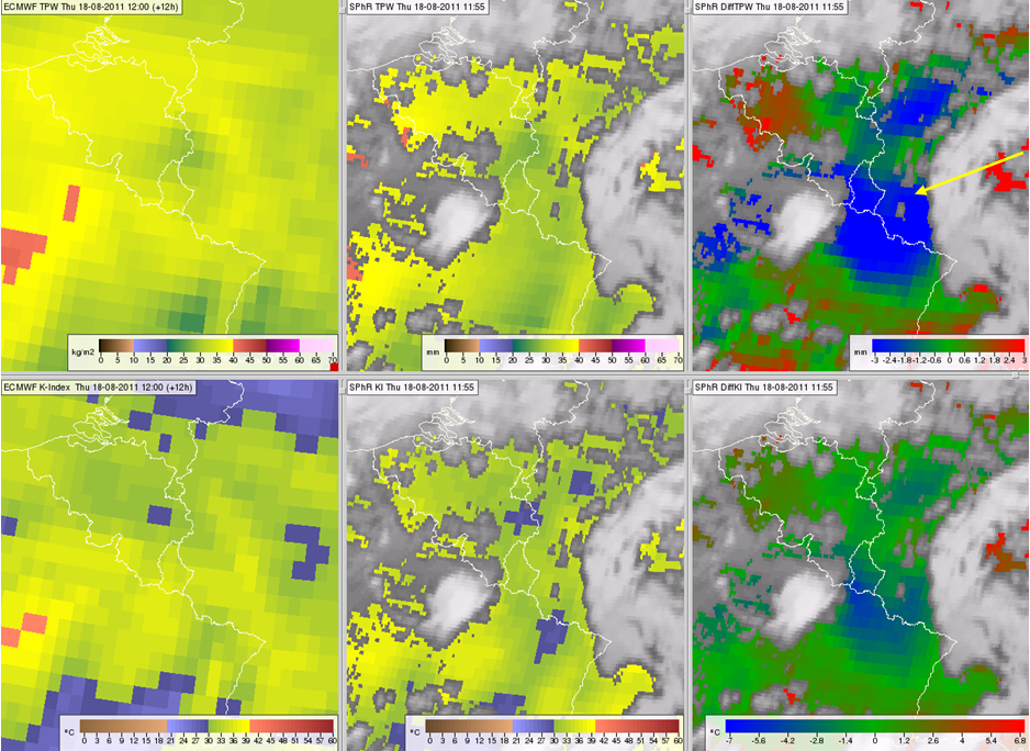
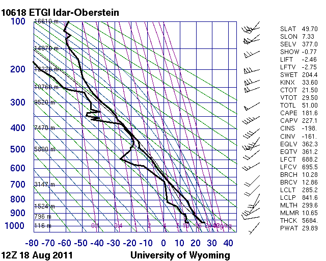
Besides presenting examples for the SPhR outputs, we show also a comparison with a radiosonde measurement. We compared ECMWF's forecasted and satellite-retrieved TPW and K-index values with the corresponding radiosonde measurements from the Idar-Oberstein station at 12 UTC. Fig. 7 presents the ECMWF forecasted, satellite-retrieved TPW and their difference (in top left, middle and right, respectively). The bottom panels show the same, but for the K-index. The station's location is indicated by the yellow arrow. It is located in the region where the SPhR algorithm retrieved much less TPW than forecasted by ECMWF. The radiosonde measurement in Fig. 8 was used to check whether the SPhR algorithm changed the ECMWF forecast for better or worse, that is, whether in this case SPhR improved the environmental parameters or not. Table 5 shows the results. SphR adjusted both the TPW and K-index in the right direction.
Figure 7: ECMWF forecasted and satellite-derived products from 18 August 2011, 12:00 and 11:55 UTC, respectively. ECMWF forecasted TPW (top left), SPhR TPW (top middle), difference of the satellite-derived and the ECMWF forecasted TPW (top right), ECMWF forecasted K-Index (bottom left), SPhR K-Index (bottom middle), difference of the satellite-derived and the ECMWF forecasted K-index (bottom right). The ECMWF forecast is based on 00 UTC data, valid for 12 UTC
Figure 8: Radiosonde data measured on 18 August 2011 at 12 UTC in Idar-Oberstein, Germany
| Radiosonde | SPhR | ECMWF (00+12) | |
|---|---|---|---|
| TPW [mm] | 29.89 | 30.0 | 34.6 |
| K-index [°C] | 33.60 | 32.8 | 35.3 |
Table 5: TPW and K-index derived from radiosonde measurements, satellite data and the ECMWF model's forecast. The ECMWF model is run at 00 UTC, and valid for 12 UTC.
Note that the dry mid-layer very likely played an important role in the formation of the severe storm that caused material damage and loss of life in Belgium on 18 August 2011. A detailed study about this case was published on the EUMeTrain website ( http://www.eumetrain.org/resources/pukkelpop_storm_2012.html ).
