Moisture content
An evaluation of humidity distribution is critical in order to determine the possibilities of convection, severe weather and heavy precipitation. Storms usually develop where humidity is already high or where some mechanism causes it to increase.
The satellite-derived products can improve the numerically forecasted moisture distribution. This improvement - while usually minor - might still be important. The SPhR product finds the locations of TPW gradient zones (moisture boundaries) fairly well. These boundaries are important in weather forecasting. Such zones are favorable even for intense convection, because on one side there is enough moisture and on the other (dryer) side the heating is stronger (see also http://eumetrain.org/satmanu/, Fair Weather Conditions). If the moisture boundary is accompanied by low-level convergence, the lifting mechanism required for convection is also present.
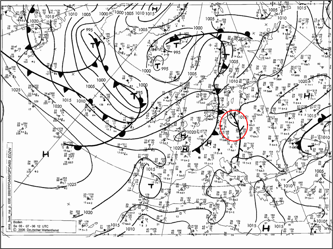
Such a situation occurred on 8 July 2006 (Kovács, 2012). A convergence line developed ahead of a cold front (Fig. 1). The area we will focus on is circled in red.
Figure 1: DWD surface chart, 8 July 2006, 12 UTC
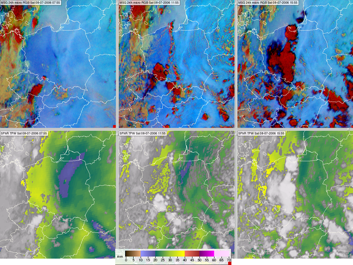
In the 24 hour Microphysics RGB (upper panels of Fig. 2), a north-south moisture boundary is seen over Poland, separating moist air in the west from dry air in the east. Thunderstorms developed during the day along this line. The moisture boundary is clearly visible in the SPhR TPW product (lower panels of Fig. 2).
Figure 2: 24 hour Microphysics RGB images (top row) and SPhR TPW products (bottom row) for 8 July 2006 at 07:55, 11:55 and 15:55 UTC in the left, middle and right panels, respectively.
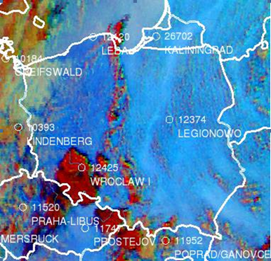
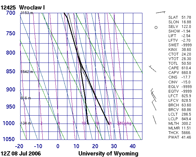
To check the satellite TPW retrieval and the interpretation of the RGB colors (dark blue as more moist, light blue as less moist at low levels) radiosonde data were studied. Fig. 3 shows soundings measured in Legionowo (east of the moisture boundary) and Wroclaw (west of it). In Legionowo the dew point depression was almost twice as high as in Wroclaw. The radiosonde-derived TPW values were 25.75 mm in Legionowo and 41.46 mm in Wroclaw, confirming that the moisture content was much higher in western than eastern Poland.
 |
|
 |
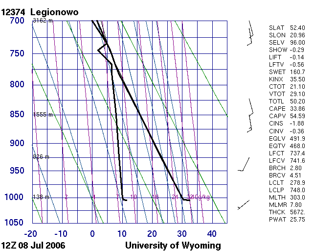 |
Figure 3: 24 hour Microphysics RGB overlaid with radiosonde station locations and names (top) and radiosonde profiles measured in Wroclaw and Legionowo on 8 July 2006, 12 UTC
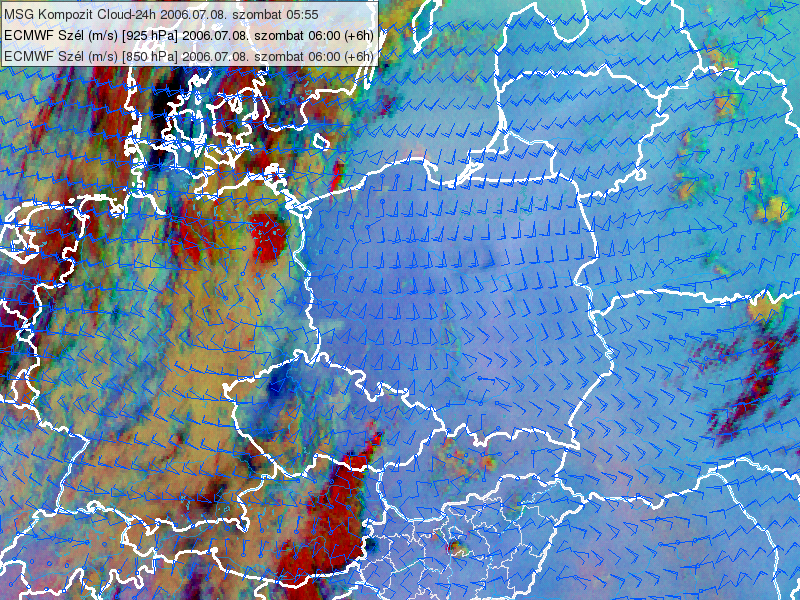
The ECMWF model forecasted both the convergence (see the wind barbs in the left panel of Fig. 4) and the moisture boundary well (see the isohumes, i.e. isolines of relative humidity in the right panel of Fig. 4). In the forecast there was about 30% RH difference between east and west Poland.
 |
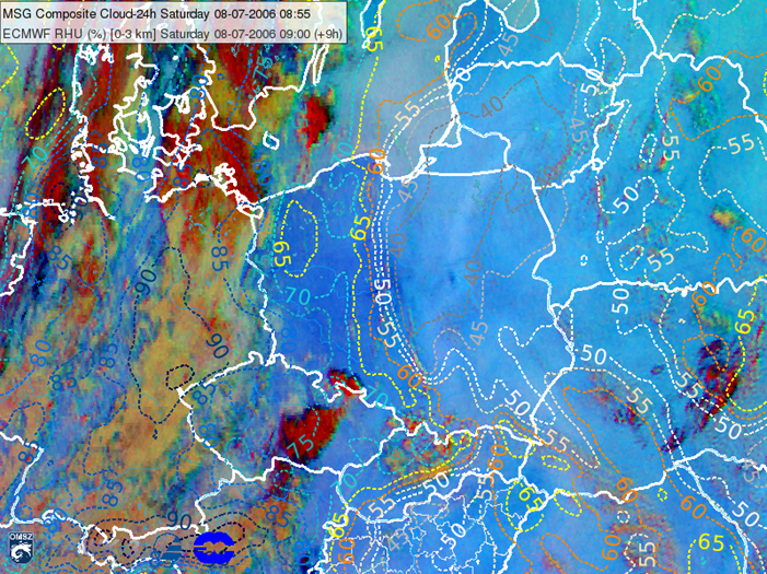 |
Figure 4: 24 hour Microphysics RGB from 8 July 2006, 05:55 UTC overlaid with ECMWF 850 and 925 hPa wind fields (00+06 UTC) (left) and 24 hour Microphysics RGB from 8 July 2006 at 08:55 UTC overlaid with the average of the 1000, 925, 850 and 700 hPa ECMWF Relative Humidity (00+09 UTC), 8 July 2006, 09 UTC (right). (Courtesy of Kovács Adrián, ELTE University)
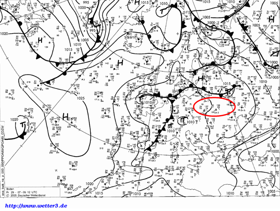
In this and many other cases the ECMWF model forecasted the moisture boundary well. However, these forecasts are not always as successful. For example, on 29 July 2005 ECMWF did not forecast the tightening of the moisture gradient over Poland and Ukraine (Kovács, 2012). On that day, convective systems and intense precipitation formed ahead of a wavy front (see area circled in red in Fig. 5).
Figure 5: DWD surface chart, 29 July 2005, 12 UTC
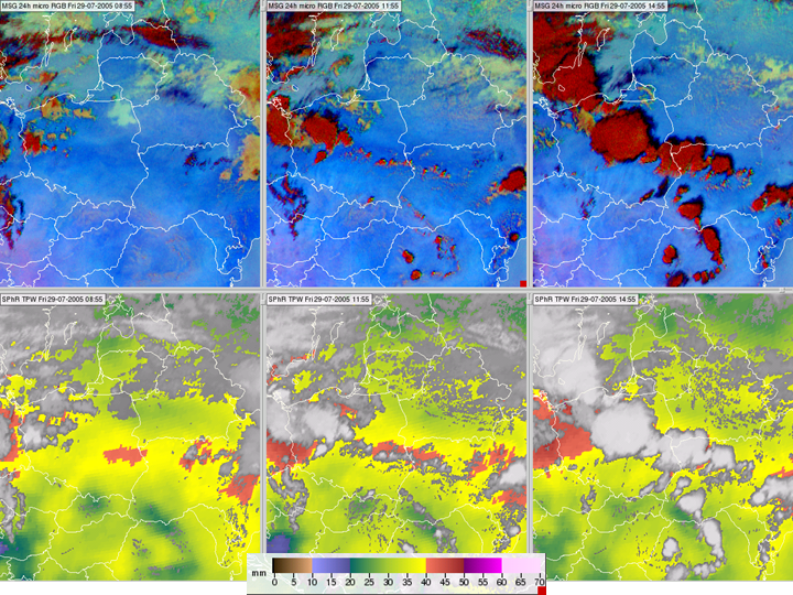
A roughly west-east oriented darker blue band lies over central Poland in the 24 hour Microphysics RGB (see upper panels of Fig. 6), hinting at higher amounts of low-level moisture in the band. The lower panels show the satellite-retrieved TPW, which gives extreme high TPW values in this band (around 40 mm). Thunderstorms developed along this band.
Figure 6: 24 hour Microphysics RGB images (upper row) and SPhR TPW products (bottom row) for 29 July 2005, 08:55, 11:55 and 14:55 UTC in the left, middle and right panels, respectively
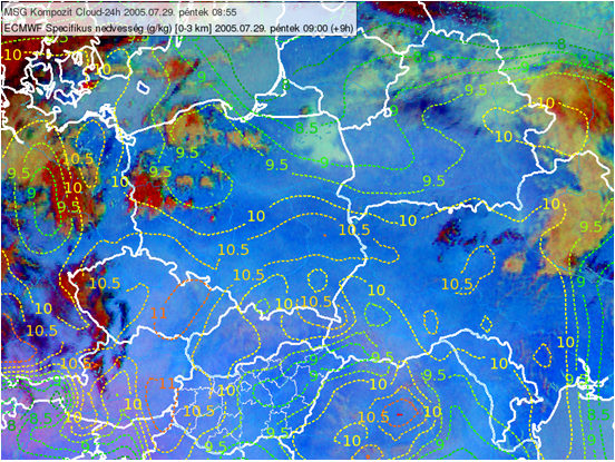
ECMWF did not forecast this distinct moisture band. Fig. 7 shows the average values of the forecasted 1000, 925, 850 and 700 hPa specific and relative humidity, respectively.
 |
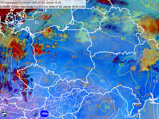 |
Figure 7: 24 hour Microphysics RGB from 29 July 2005 at 08:55 UTC overlaid with a ECMWF specific humidity forecast (left) and relative humidity forecast (right), 29 July 2005 at 09 UTC. The average of the humidity fields at 1000, 925, 850 and 700 hPa levels are shown as dashed isolines. (Courtesy of Kovács Adrián, ELTE University)
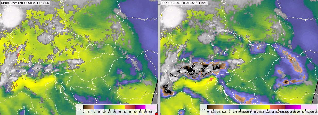
Besides TPW, the layer water vapor content is also useful information. The majority of moisture is usually found in the low levels, depending on vertical mixing. SPhR uses 850 hPa as a threshold boundary between low levels (BL) and mid-levels (ML), with this separation ML is often higher than BL. As the top of the BL is at a fixed pressure level, 850 hPa, and the base is at the surface, the moisture content of this layer depends strongly on topography. The effect of topography is seen in TPW as well, like in Fig. 8, where the mountains are evident. For pixels where surface pressure is less than 850 hPa, BL is not defined; these pixels are black.
Figure 8: SPhR TPW (left) and BL (right) from 18 August 2011, 16:55 UTC
In the case of elevated convection, mid-layer moisture is a key parameter. Mid-layer moisture is also important because its relative dryness can cause strong downdrafts and strong surface winds (e.g. Gilmore and Wicker, 1998). We will discuss this further in Chapter VI and the case study of 25 May 2010 in Chapter VII.
The high-level moisture product is not discussed because its moisture content is very low, almost negligible relative to TPW, and it is not interesting for nowcasting purposes.
