Air Mass RGB
Just as every RGB composite, the Air Mass RGB combines several satellite channels in order to gain better information or highlight special features. As both water vapor channels (WV 6.2 µm and WV 7.3 µm) are included in this composite, the main applications are the detection of dynamic processes, such as rapid cyclogenesis, jet streams and PV anomalies.
Composition
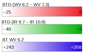
The Air Mass RGB is composed as follows (figure 5):
- RED = Brightness temperature difference (WV6.2 – WV7.3)
- GREEN = Brightness temperature difference (IR9.7 – IR10.8)
- BLUE = Brightness temperature WV6.2
Figure 5: Composition and temperature range of the three colour beams of the Air Mass RGB.
The red beam reflects vertical water vapor distribution. A large proportion of red in the image is a sign of dry conditions at high levels.
The brightness temperature difference of the two IR channels on the green beam depicts an estimation of the tropopause height based on ozone concentration. A positive temperature difference is a sign of a high tropopause and tropical air mass.
The brightness temperature of the WV 6.2 µm channel on the blue beam shows the water vapour content in a layer between approximately 200 and 500 hPa. As the blue scale is inverted, moist upper levels and low brightness temperatures result in a large proportion of blue colour.
Applications
Air Mass RGBs can help detect areas of high PV advection (and therefore jet streaks and developing rapid cyclogenesis). The so-called stratospheric intrusions, where dry and ozone-rich air protrudes down into the troposphere, are shown in red to orange colors in the Air Mass RGB. They indicate zones of high PV advection.
The green component is small in these intrusions because the ozone concentration is large and the tropopause is low and warm. The IR9.7 channel's brightness temperature is therefore much lower than that of the IR10.8 channel. The WV6.2 brightness temperature is high, and therefore the blue component is also small.
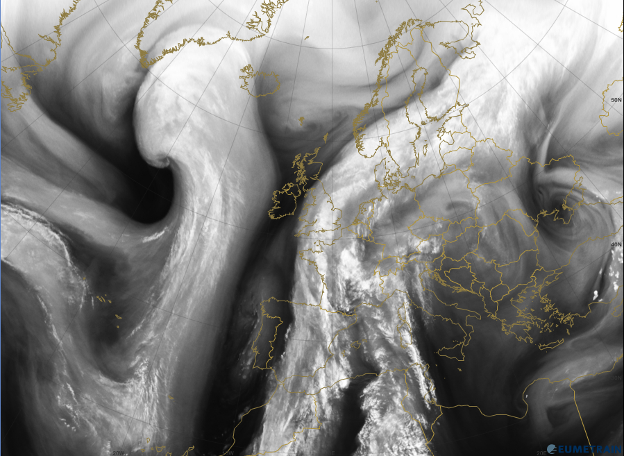
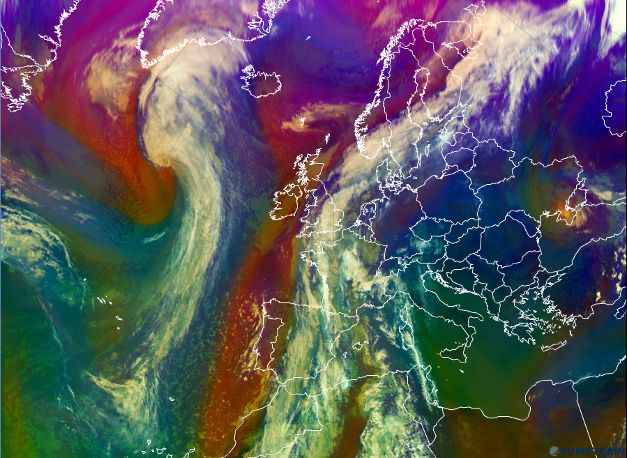
Figure 6a and 6b show the WV 6.2 µm image and the Air Mass RGB from 19 October 2012 at 12:00 UTC. The dark stripes in figure 6a, showing dry areas in higher levels of the troposphere, can be clearly seen. The dark stripes of figure 6a appear red or deep orange in figure 6b. Note that the correspondence between the dark and red stripes only applies when the blue and green contributions are small, such as in the areas behind cold fronts.
Figure 6a: WV 6.2 µm image, 19 October 2012, 12:00 UTC.
Figure 6b: Air Mass RGB, 19 October, 2012, 12:00 UTC.
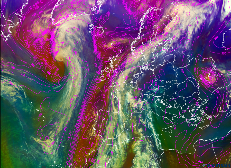
When comparing the Air Mass RGB to the model PV=1.5 PVU surface height (figure 7), a clear correspondence can be observed between the red areas and PV anomalies. As mentioned earlier in chapter 2, dry stratospheric intrusions are a sign of potential vorticity advection to lower levels caused by conservation of PV. Therefore, when red or orange colors occur near fronts or occlusions in Air Mass RGBs, they can be an indication of rapid cyclogenesis or increasing destabilisation.
Figure 7: Air Mass RGB overlaid with 1.5 PVU surface height (pink), 19 October 2012, 12:00 UTC.
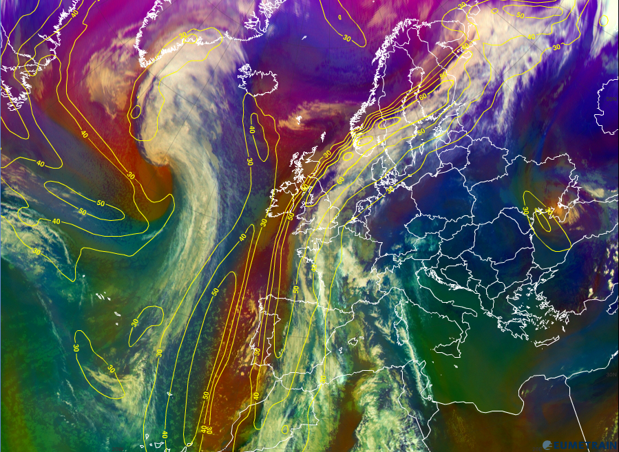
Figure 8: Air Mass RGB and ECMWF model field of the 300 hPa isotachs (yellow), 19 October 2012, 12:00 UTC.
The connection between dark stripes and the position of jet streaks was explained in previous chapters. As dark stripes connected to frontal rear sides correspond to orange or red stripes in the Air Mass RGB, this RGB can also be used for the location of jet axes. In figure 8 the Air Mass RGB is overlaid by the ECMWF model field of the 300 hPa isotachs. One can clearly see that the red stripes are on the cold side of the (model) jet axis.
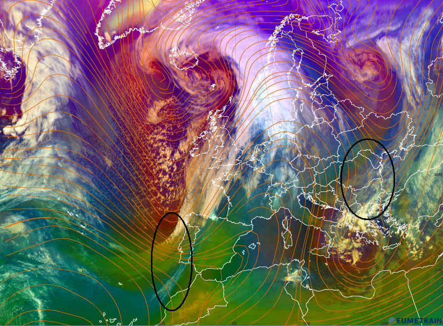
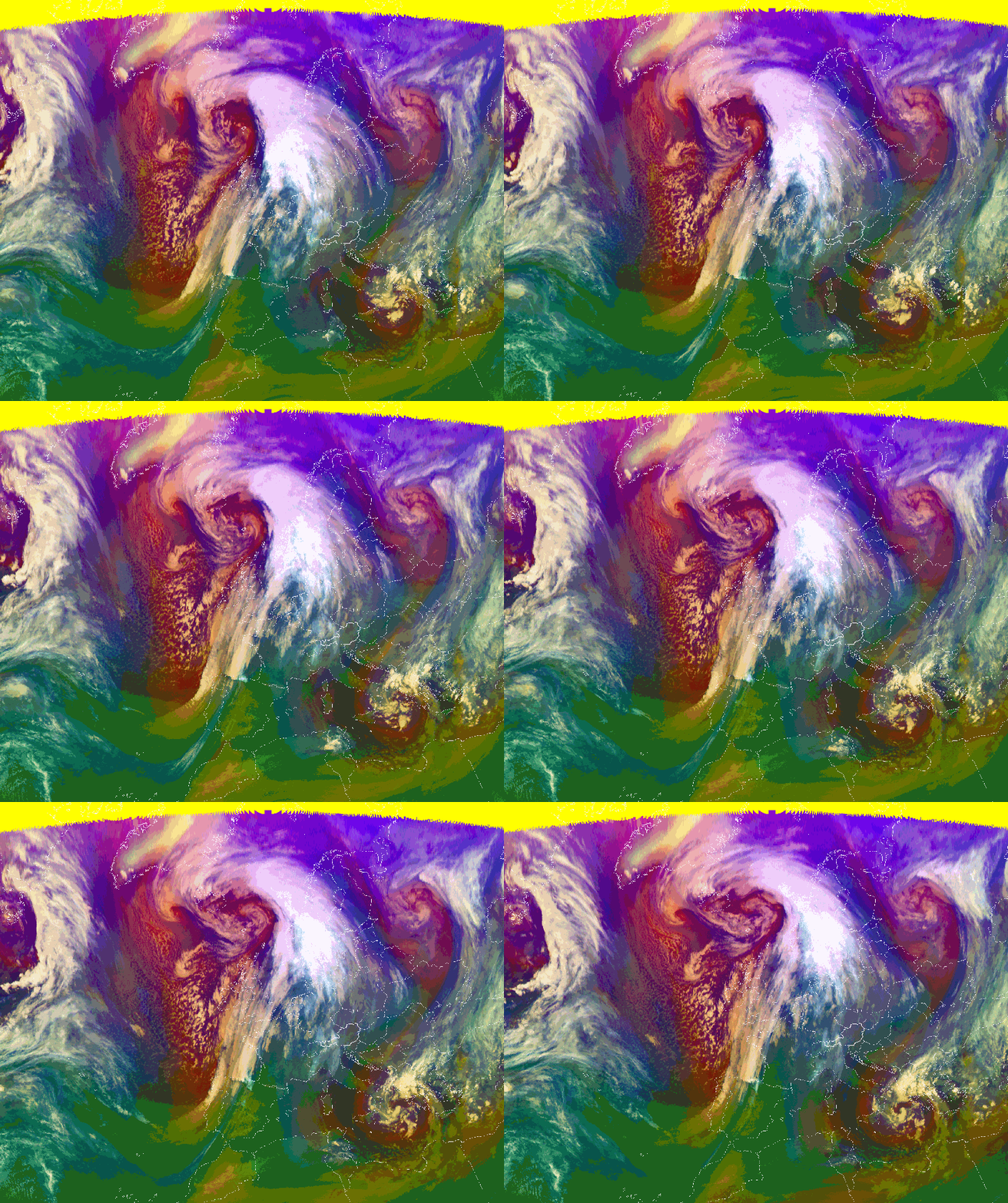
As deformation zones can be detected with the help of a WV image loop (see chapter 6 for deformation zones), the same is also true for the Air Mass RGB loop. Figure 9 shows two deformation zones.
Figure 9: Air Mass RGB overlaid with the ECMWF model field of the 300 hPa streamlines, 29 December 2012, 06:00 UTC. The black circles mark the deformation zones.
Figure 10: Air Mass RGB loop from 03:00 UTC 09:00 UTC, 29 December 2012.
Notice:
| Red areas are not always showing areas of dry descending stratospheric air with high potential vorticity. |
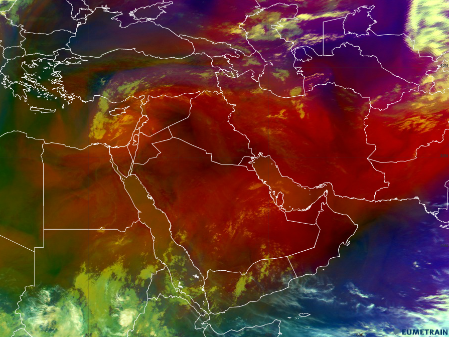
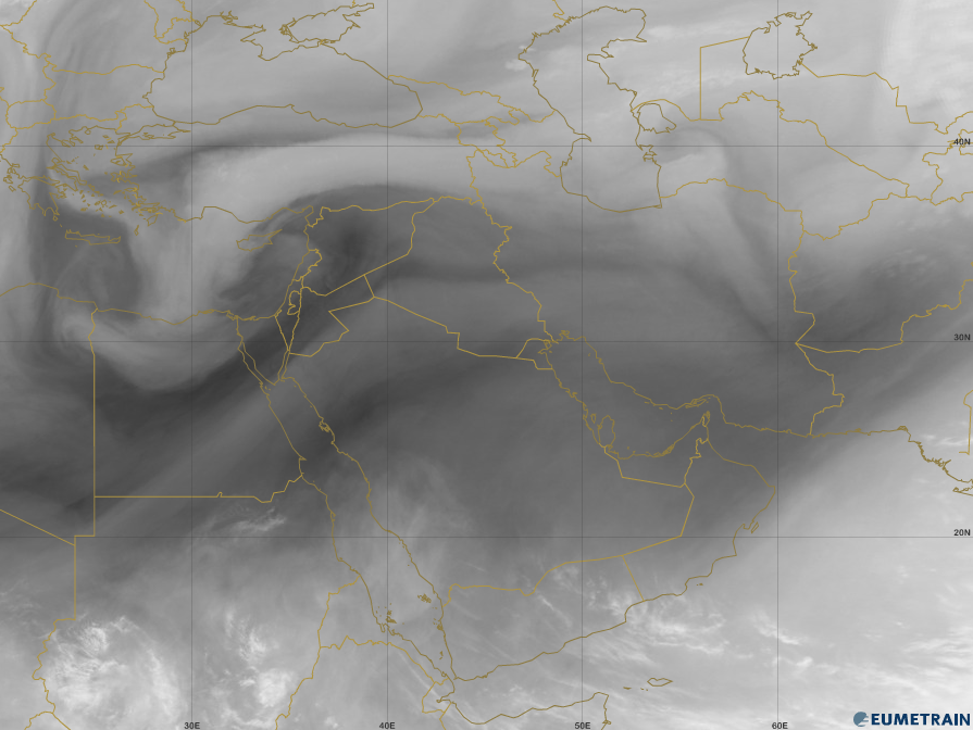
Figure 11a shows a summertime Air Mass RGB image of the Middle East, where red colours are dominating the image. In this image the red to dark red colours indicate very high surface temperatures and low upper tropospheric humidity. A hint to discern dynamic tropopause anomalies from hot and dry areas: If the Air Mass RGB shows red colours because of high surface temperatures, those areas naturally only occur over land. For comparison one can look at the WV 6.2 µm image of the same date (figure 11b); no significant dark stripes can be seen there.
Figure 11a: Air Mass RGB over the Middle East, 22 June 2012, 06:00 UTC.
Figure 11b: WV 6.2 µm over the Middle East, 22 June 2012, 06:00 UTC.
Question
The image below shows an Air Mass RGB from 7 June 2013, 12:00 UTC. Try to find regions with descending dry stratospheric air.
Question
The image below shows an Air Mass RGB from 23 July 2012, 12:00 UTC. Try to find warm air masses.
