Jason-2 radar
Radar altimetry satellites have been measuring the Earth’s oceans since 1991. The Ocean Surface Topography Mission (OSTM) Jason-2 is an international satellite mission that joins EUMETSAT, NOAA, CNES and NASA [1]. OSTM/Jason-2 (Fig. 2) is a satellite altimeter and therefore has the capability to estimate wave height, wind speed and sea surface height.
Fig.2. Illustration of Jason-2 satellite. Click here to read more about it.
Radar altimeters are active sensors (they emit electromagnetic radiation) that operate in the microwave frequency range; this makes them able to measure sea-state variables along the satellite track. The advantage of this sensor in comparison to optical sensors is the fact that radar sensors are, generally, unaffected by the structure and composition of the atmosphere.
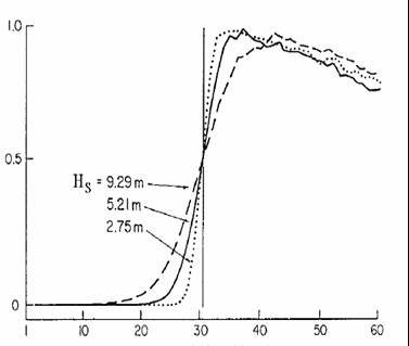
The Jason-2 altimeter emits microwaves on two different frequencies (5.3 and 13.6 GHz) toward the ocean and measures the characteristics of the echo [2] [3]. Wave height estimations are then calculated from the magnitude and shape of the impulse received by the altimeter after it is reflected from the ocean’s surface (Fig. 3).
Fig.3. Time variations of the radar wave power after reflection from the sea surface as a function of different SWH values (From Chelton (1988)).
The satellite moves in a low Earth orbit at an altitude of 1336 km, providing global coverage between 66°N and 66°S latitude and a 10-day repeat of the ground track with a 7 km resolution [4]. As a result, Jason-2 maps 95% of the world's ice-free oceans every ten days, providing SWH values with a mean accuracy of 0.5o m (or 10%) [5].
Altimeter measurements reliably provide oceanographic data important to climate change monitoring, large-scale ocean circulation, mesoscale processes (e.g., currents and eddies), tides and tsunamis. Additionally, Jason-2 measurements contribute to the European Centre for Medium-Range Weather Forecasts (ECMWF) satellite data assimilation, providing more accurate ocean wave analyses and forecasts [6]. Real-time altimeter data is also used to support operational marine forecasts, mainly in oceanic areas with a lack of observations.

