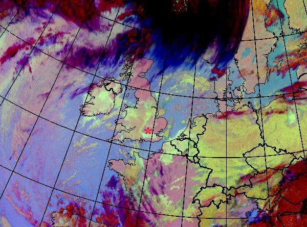

Anticyclone centered over the British Isles. Frontal clouds in the north and west seen as dark red-black in night-time RGB, as cyan-white in daytime RGB. The low clouds seen as greenish against the pinkish cloud-free areas. In daytime images the inclusion of 1.6 micron channel allows us to differentiate between water and ice phase the clouds (water clouds appear as pinkish in contrast to cyan ice clouds). The fog layer over the UK clearly consists only of water droplets during the period 19-22 December, but on 23 December daytime image shows that the top layer of fog has also ice particles in Central parts of UK.
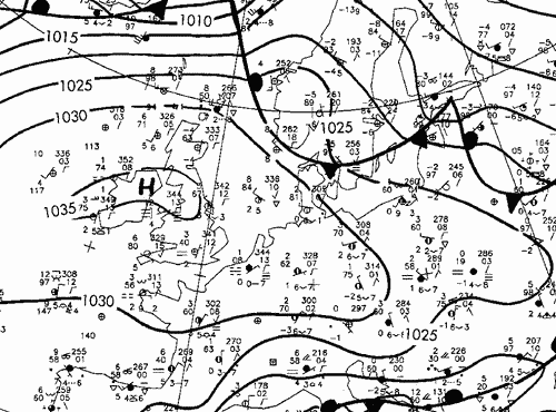 |
Frontal analysis 19 December 2006/00 UTC |
Anticyclone centered over the British Isles. Frontal clouds in the north and west seen as dark red-black in night-time RGB, as cyan-white in daytime RGB. The low clouds seen as greenish against the pinkish cloud-free areas. In daytime images the inclusion of 1.6 micron channel allows us to differentiate between water and ice phase the clouds (water clouds appear as pinkish in contrast to cyan ice clouds). The fog layer over the UK clearly consists only of water droplets during the period 19-22 December, but on 23 December daytime image shows that the top layer of fog has also ice particles in Central parts of UK.
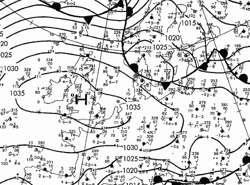 |
Frontal analysis 19 December 2006/06 UTC |
Anticyclone centered over the British Isles. Frontal clouds in the north and west seen as dark red-black in night-time RGB, as cyan-white in daytime RGB. The low clouds seen as greenish against the pinkish cloud-free areas. In daytime images the inclusion of 1.6 micron channel allows us to differentiate between water and ice phase the clouds (water clouds appear as pinkish in contrast to cyan ice clouds). The fog layer over the UK clearly consists only of water droplets during the period 19-22 December, but on 23 December daytime image shows that the top layer of fog has also ice particles in Central parts of UK.
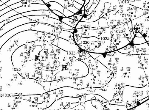 |
Frontal analysis 19 December 2006/12 UTC |
Anticyclone centered over the British Isles. Frontal clouds in the north and west seen as dark red-black in night-time RGB, as cyan-white in daytime RGB. The low clouds seen as greenish against the pinkish cloud-free areas. In daytime images the inclusion of 1.6 micron channel allows us to differentiate between water and ice phase the clouds (water clouds appear as pinkish in contrast to cyan ice clouds). The fog layer over the UK clearly consists only of water droplets during the period 19-22 December, but on 23 December daytime image shows that the top layer of fog has also ice particles in Central parts of UK.
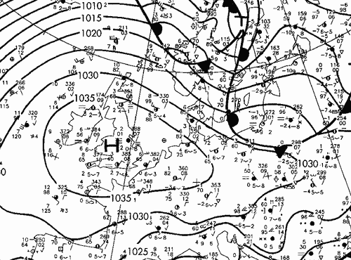 |
Frontal analysis 19 December 2006/18 UTC |
Anticyclone centered over the British Isles. Frontal clouds in the north and west seen as dark red-black in night-time RGB, as cyan-white in daytime RGB. The low clouds seen as greenish against the pinkish cloud-free areas. In daytime images the inclusion of 1.6 micron channel allows us to differentiate between water and ice phase the clouds (water clouds appear as pinkish in contrast to cyan ice clouds). The fog layer over the UK clearly consists only of water droplets during the period 19-22 December, but on 23 December daytime image shows that the top layer of fog has also ice particles in Central parts of UK.
 |
Frontal analysis 19 December 2006/00 UTC |
Anticyclone centered over the British Isles. Frontal clouds in the north and west seen as dark red-black in night-time RGB, as cyan-white in daytime RGB. The low clouds seen as greenish against the pinkish cloud-free areas. In daytime images the inclusion of 1.6 micron channel allows us to differentiate between water and ice phase the clouds (water clouds appear as pinkish in contrast to cyan ice clouds). The fog layer over the UK clearly consists only of water droplets during the period 19-22 December, but on 23 December daytime image shows that the top layer of fog has also ice particles in Central parts of UK.
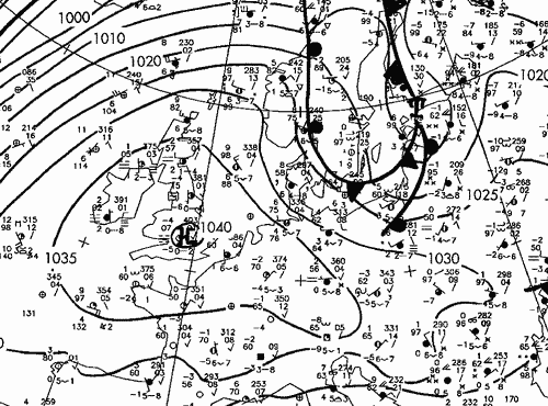 |
Frontal analysis 20 December 2006/06 UTC |
Anticyclone centered over the British Isles. Frontal clouds in the north and west seen as dark red-black in night-time RGB, as cyan-white in daytime RGB. The low clouds seen as greenish against the pinkish cloud-free areas. In daytime images the inclusion of 1.6 micron channel allows us to differentiate between water and ice phase the clouds (water clouds appear as pinkish in contrast to cyan ice clouds). The fog layer over the UK clearly consists only of water droplets during the period 19-22 December, but on 23 December daytime image shows that the top layer of fog has also ice particles in Central parts of UK.
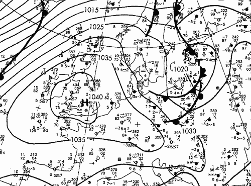 |
Frontal analysis 20 December 2006/12 UTC |
Anticyclone centered over the British Isles. Frontal clouds in the north and west seen as dark red-black in night-time RGB, as cyan-white in daytime RGB. The low clouds seen as greenish against the pinkish cloud-free areas. In daytime images the inclusion of 1.6 micron channel allows us to differentiate between water and ice phase the clouds (water clouds appear as pinkish in contrast to cyan ice clouds). The fog layer over the UK clearly consists only of water droplets during the period 19-22 December, but on 23 December daytime image shows that the top layer of fog has also ice particles in Central parts of UK.
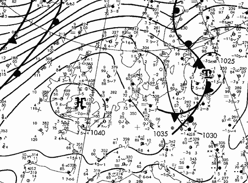 |
Frontal analysis 20 December 2006/18 UTC |
Anticyclone centered over the British Isles. Frontal clouds in the north and west seen as dark red-black in night-time RGB, as cyan-white in daytime RGB. The low clouds seen as greenish against the pinkish cloud-free areas. In daytime images the inclusion of 1.6 micron channel allows us to differentiate between water and ice phase the clouds (water clouds appear as pinkish in contrast to cyan ice clouds). The fog layer over the UK clearly consists only of water droplets during the period 19-22 December, but on 23 December daytime image shows that the top layer of fog has also ice particles in Central parts of UK.
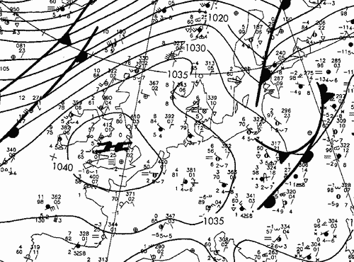 |
Frontal analysis 21 December 2006/00 UTC |
Anticyclone centered over the British Isles. Frontal clouds in the north and west seen as dark red-black in night-time RGB, as cyan-white in daytime RGB. The low clouds seen as greenish against the pinkish cloud-free areas. In daytime images the inclusion of 1.6 micron channel allows us to differentiate between water and ice phase the clouds (water clouds appear as pinkish in contrast to cyan ice clouds). The fog layer over the UK clearly consists only of water droplets during the period 19-22 December, but on 23 December daytime image shows that the top layer of fog has also ice particles in Central parts of UK.
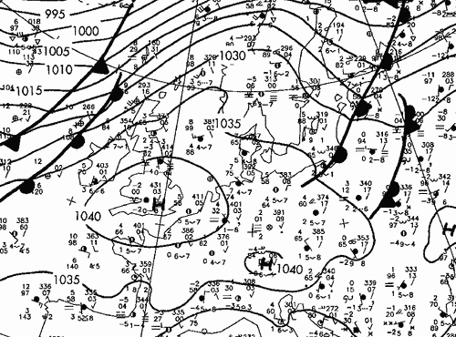 |
Frontal analysis 21 December 2006/06 UTC |
Anticyclone centered over the British Isles. Frontal clouds in the north and west seen as dark red-black in night-time RGB, as cyan-white in daytime RGB. The low clouds seen as greenish against the pinkish cloud-free areas. In daytime images the inclusion of 1.6 micron channel allows us to differentiate between water and ice phase the clouds (water clouds appear as pinkish in contrast to cyan ice clouds). The fog layer over the UK clearly consists only of water droplets during the period 19-22 December, but on 23 December daytime image shows that the top layer of fog has also ice particles in Central parts of UK.
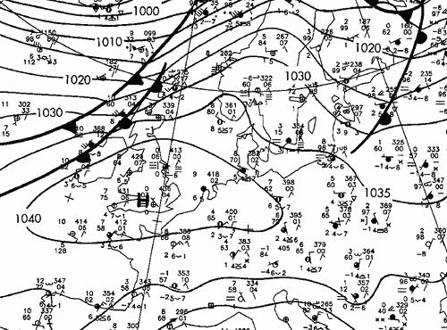 |
Frontal analysis 21 December 2006/12 UTC |
Anticyclone centered over the British Isles. Frontal clouds in the north and west seen as dark red-black in night-time RGB, as cyan-white in daytime RGB. The low clouds seen as greenish against the pinkish cloud-free areas. In daytime images the inclusion of 1.6 micron channel allows us to differentiate between water and ice phase the clouds (water clouds appear as pinkish in contrast to cyan ice clouds). The fog layer over the UK clearly consists only of water droplets during the period 19-22 December, but on 23 December daytime image shows that the top layer of fog has also ice particles in Central parts of UK.
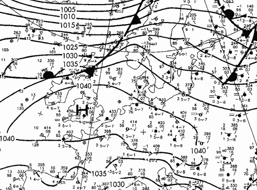 |
Frontal analysis 21 December 2006/18 UTC |
Anticyclone centered over the British Isles. Frontal clouds in the north and west seen as dark red-black in night-time RGB, as cyan-white in daytime RGB. The low clouds seen as greenish against the pinkish cloud-free areas. In daytime images the inclusion of 1.6 micron channel allows us to differentiate between water and ice phase the clouds (water clouds appear as pinkish in contrast to cyan ice clouds). The fog layer over the UK clearly consists only of water droplets during the period 19-22 December, but on 23 December daytime image shows that the top layer of fog has also ice particles in Central parts of UK.
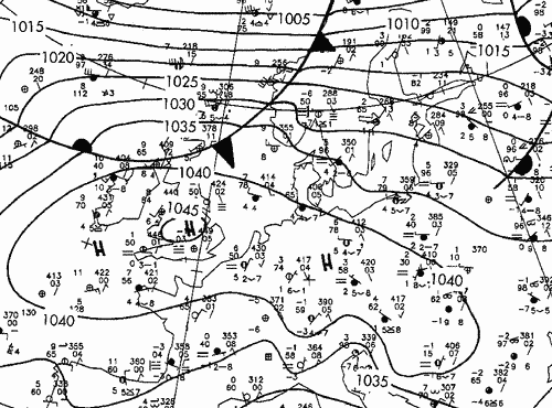 |
Frontal analysis 22 December 2006/00 UTC |
Anticyclone centered over the British Isles. Frontal clouds in the north and west seen as dark red-black in night-time RGB, as cyan-white in daytime RGB. The low clouds seen as greenish against the pinkish cloud-free areas. In daytime images the inclusion of 1.6 micron channel allows us to differentiate between water and ice phase the clouds (water clouds appear as pinkish in contrast to cyan ice clouds). The fog layer over the UK clearly consists only of water droplets during the period 19-22 December, but on 23 December daytime image shows that the top layer of fog has also ice particles in Central parts of UK.
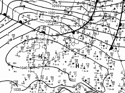 |
Frontal analysis 22 December 2006/06 UTC |
Anticyclone centered over the British Isles. Frontal clouds in the north and west seen as dark red-black in night-time RGB, as cyan-white in daytime RGB. The low clouds seen as greenish against the pinkish cloud-free areas. In daytime images the inclusion of 1.6 micron channel allows us to differentiate between water and ice phase the clouds (water clouds appear as pinkish in contrast to cyan ice clouds). The fog layer over the UK clearly consists only of water droplets during the period 19-22 December, but on 23 December daytime image shows that the top layer of fog has also ice particles in Central parts of UK.
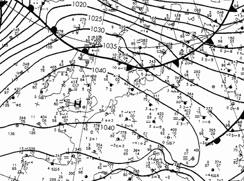 |
Frontal analysis 22 December 2006/12 UTC |
Anticyclone centered over the British Isles. Frontal clouds in the north and west seen as dark red-black in night-time RGB, as cyan-white in daytime RGB. The low clouds seen as greenish against the pinkish cloud-free areas. In daytime images the inclusion of 1.6 micron channel allows us to differentiate between water and ice phase the clouds (water clouds appear as pinkish in contrast to cyan ice clouds). The fog layer over the UK clearly consists only of water droplets during the period 19-22 December, but on 23 December daytime image shows that the top layer of fog has also ice particles in Central parts of UK.
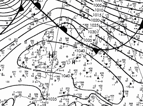 |
Frontal analysis 22 December 2006/18 UTC |
Anticyclone centered over the British Isles. Frontal clouds in the north and west seen as dark red-black in night-time RGB, as cyan-white in daytime RGB. The low clouds seen as greenish against the pinkish cloud-free areas. In daytime images the inclusion of 1.6 micron channel allows us to differentiate between water and ice phase the clouds (water clouds appear as pinkish in contrast to cyan ice clouds). The fog layer over the UK clearly consists only of water droplets during the period 19-22 December, but on 23 December daytime image shows that the top layer of fog has also ice particles in Central parts of UK.
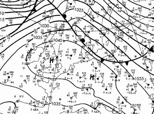 |
Frontal analysis 23 December 2006/00 UTC |
Anticyclone centered over the British Isles. Frontal clouds in the north and west seen as dark red-black in night-time RGB, as cyan-white in daytime RGB. The low clouds seen as greenish against the pinkish cloud-free areas. In daytime images the inclusion of 1.6 micron channel allows us to differentiate between water and ice phase the clouds (water clouds appear as pinkish in contrast to cyan ice clouds). The fog layer over the UK clearly consists only of water droplets during the period 19-22 December, but on 23 December daytime image shows that the top layer of fog has also ice particles in Central parts of UK.
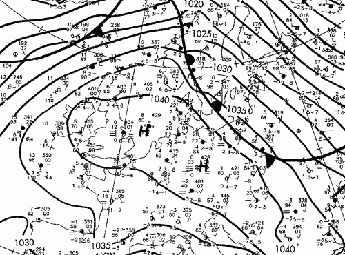 |
Frontal analysis 23 December 2006/06 UTC |
Anticyclone centered over the British Isles. Frontal clouds in the north and west seen as dark red-black in night-time RGB, as cyan-white in daytime RGB. The low clouds seen as greenish against the pinkish cloud-free areas. In daytime images the inclusion of 1.6 micron channel allows us to differentiate between water and ice phase the clouds (water clouds appear as pinkish in contrast to cyan ice clouds). The fog layer over the UK clearly consists only of water droplets during the period 19-22 December, but on 23 December daytime image shows that the top layer of fog has also ice particles in Central parts of UK.
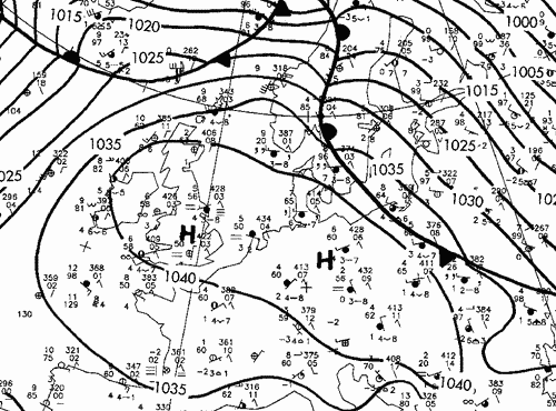 |
Frontal analysis 23 December 2006/12 UTC |
Anticyclone centered over the British Isles. Frontal clouds in the north and west seen as dark red-black in night-time RGB, as cyan-white in daytime RGB. The low clouds seen as greenish against the pinkish cloud-free areas. In daytime images the inclusion of 1.6 micron channel allows us to differentiate between water and ice phase the clouds (water clouds appear as pinkish in contrast to cyan ice clouds). The fog layer over the UK clearly consists only of water droplets during the period 19-22 December, but on 23 December daytime image shows that the top layer of fog has also ice particles in Central parts of UK.
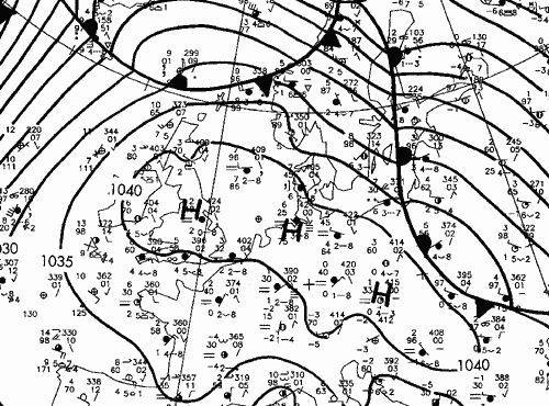 |
Frontal analysis 23 December 2006/18 UTC |