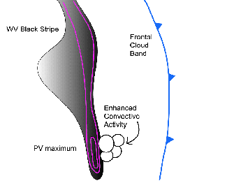
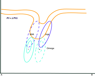
If stratospheric air is penetrating into the troposphere, a PV anomaly associated with
the vorticity maximum will be observed. The reason
for this is that the static stability in the troposphere is significantly lower than in the stratosphere. In the troposphere, the distance
between isentropic surfaces is much larger than in the stratosphere. As a result, relative vorticity will increase. In the case of a
propagation of the PV anomaly, there will be advection of positive vorticity ahead of the anomaly and advection of negative vorticity
behind it. The advection of positive vorticity, if increasing with height, causes divergence in the upper troposphere and, as a consequence,
upward motion.
Although potential vorticity (PV) and vorticity advection (VA) are strongly connected, the use of PV as a key parameter, together with
the WV image, is often more illustrative than using PVA patterns alone. When a PV anomaly approaches an area of moist and potentially
unstable air, strong convection is initiated and convection systems such as EC, Comma, Cb Clusters or MCS can develop. Additionally decaying
systems can intensify through this process. Locations favourable for these phenomena are in cold air
at the rear of frontal cloud bands.

|

|
References