
![]()
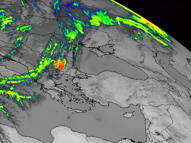
The frontal system approaches Turkey from the north-west. At the leading edge of the front a big convective cell, coloured in red, can be recognised. The red colours indicate brightness temperatures (BT) around -70 °C. The cold cloud tops consist of ice particles.
![]()
The large convective cell has grown in the past hour. Apart from that cell, an isolated Cb is recognised over Greece with BT up to -70 °C.
![]()
Strong development at the leading edge of the frontal zone continues, and so does the orographically induced convection over Greece. A few small cold clouds over western Turkey can be observed, as well as a new cell within the frontal cloud-band.
![]()
The second cell, to the SW of the first one, experiences intensive development. The cloud tops of the cell over Greece are getting warmer indicating dissipation.
![]()
The MCS embedded into the frontal system develops further and the cloud tops became redder in this enhanced IR image. BT under -65° C (orange and red colour) are displayed in wide area within the front.
![]()
During last few time steps the level of convectivity over Turkey and Greece decreased.
![]()
Two big MCSs merged within the frontal cloud band. BT is still up to -70 °C.
![]()
Two big MCSs merged within the frontal cloud band. BT is still up to -70 °C.
![]()
Red areas are vanishing and more orange colour can be noticed over frontal zone. Temperature of the coldest cloud tops is rising to about -60 °C.
![]()
Enhanced IR shows less cold cloud tops within the frontal zone. The red and orange colours seen previously have changed into yellow and green, indicating less ice particles.
![]()
The red and orange colours within the frontal zone seen previously have changed to yellow and green indicating less ice particles (BT up to –55 ° C). Ahead of the front over Turkey, near Ankara, new convective development can be observed.
![]()
Over Turkey, near Ankara, convection due to orographic lifting can be observed with BT up to - 60 °C.
![]()
Within the front, over western Turkey the convection is not present any longer. The cell near Ankara has further increased.
![]()
The cell near Ankara has grown larger and more intense. The red colour indicates BT of - 70 °C.
![]()
The changing of colours within the front indicates decaying. The large cell ahead of the front develops further.
![]()
The situation similar to the one 1 hour before.
![]()
The changing of colours in the cell ahead of the front indicates less ice particles and decaying convectivity. Frontal cloudiness over western Turkey is now only a narrow stripe.
![]()
The whole process seems to be getting weaker at the moment. Clouds are slowly dissipating both in the front, and in the cell ahead of it.
![]()
The whole process seems to be getting weaker at the moment. Clouds are slowly dissipating both in the front, and in the cell ahead of it.
![]()
The changing of colours (to yellow and green) within frontal band and ahead of the front indicates cloud decay. At this stage there are only remnants of the frontal band and the cell ahead of the front.
![]()
The changing of colours (to yellow and green) within frontal band and ahead of the front indicates cloud decay. At this stage there are only remnants of the frontal band and the cell ahead of the front.
![]()
The convection over Turkey has started again. The first sign of convection in the enhanced IR imagery over eastern Turkey with BT about -50 °C can be noticed. BT about - 50 °C is recorded. The new development starts within the cold front. Small yellow and orange dots with BT about - 60 °C can be observed.
![]()
The new development continues, reinforced by the effects of the diurnal heating.
![]()
The increasing level of convectivity over Turkey is more evident.
![]()
The increasing level of convectivity over Turkey is more evident. The several big convective cells merged within the front. The line of prefrontal convergence can be observed. Convection over eastern Turkey also increases. All developed cells have BT up to - 60 or - 70 °C.
![]()
Two large MCSs are recognised within the frontal zone with BT up to -70 °C. The development in front of the front and over eastern Turkey continues.
![]()
The development continues. The prefrontal convective line and the MCS within the front merged into one large convective system over middle Turkey.
![]()
Increasing level of convectivity is witnessed in northern and southern part of the large convective system, similar to the one over north-eastern Turkey. A new convective cell can be observed between this two large convective zones.
![]()
The convective system grow further covering biggest part of middle and eastern Turkey.
![]()
Two large areas of convection merged into one with few highly developed cells on the edge with BT up to -70 °C. The level of convection over eastern Turkey is weakening. Red and orange colours from previous time step changed to yellow and green indicating less ice particles (BT about -50 or -60 °C).
![]()
The convective system over eastern Turkey is slowly dissipating while the development at the leading edge of the frontal zone continues.
![]()
The red colours are disappearing and the cloud tops are turning orange, meaning that cloud top temperature is rising.
![]()
Convective activity over Turkey is getting weaker.
![]()
Clouds are slowly dissolving.
![]()
Clouds are slowly dissolving.
![]()
Convective clouds over Turkey are dissipating.
![]()
Most of the convection over Turkey is decaying.