30th July 2005: 06UTC
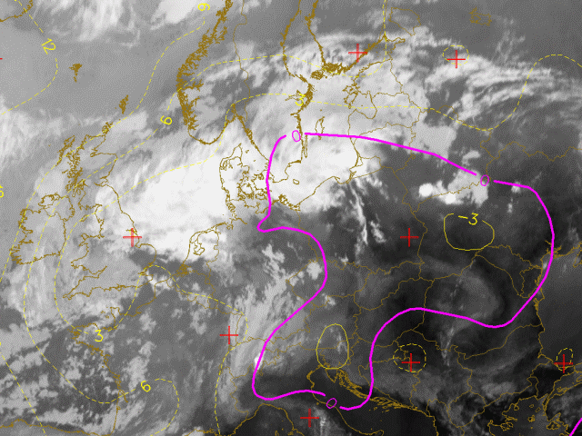
In this chapter the IR images are overlayed with the Showalter index. This index gives a good indication where the atmosphere is unstable and where convective development may be expected. A Showalter index between 1 and 4 gives the indication that thunderstorms are possible but that a trigger is still needed. From this treshold downward the chance on thunderstorms increase. Values under –3 are associated to very heavy thunderstorms. In this set of images the treshold of Showalter Index = 0 is pictured using the pink line. This allow an easy discrimination of the potential convective areas. Such an area can be seen here stretched over central Europe. South of the Alps (a region where the first signs of prefrontal convergence will be seen) the SI is even below –3.
30th July 2005: 12UTC
Ahead of the front a large area with Showalterindex below 0 is recognised. South of the Alps the atmosphere is even less stable with values under –3. In this region already a convective cells can be observed.
30th July 2005: 18UTC
A long line of prefrontal convergence is recognised. Values of Showalterindex under –3 accompany it and indicate how unstable the atmosphere is.
31st July 2005: 00UTC
Several convective areas are still seen. A large MCS is covering Poland. Most of the SI depict values over 0 so no new or further development is expected.
31st July 2005: 06UTC
Between Poland and White Russia still an MCS is embedded to the frontal system. Its size has decreased over the past 6 hours and only for the southern part the SI is still below 0.