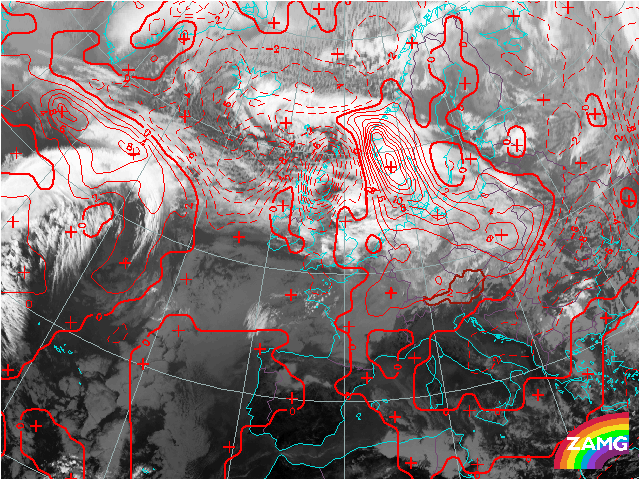

A strong advection of warm air can be found in the warm sector and the warm front band of the low pressure system over Scandinavia. The second low pressure system to the south of Greenland advects warm air to the North on its foreside. The North Atlantic is characterized mainly by cold advection at this time.
Warm advection, bringing warm air to the North and cold advection, that brings very cold air to southern latitudes lead to an increasing temperature gradient over the Atlantic.
The temperature gradient keeps increasing. Frontogenetic processes west of Great Britain cause the formation of the wave structure that will transform into a cyclone later. This leads to the storm cyclone in the Tatra Mountains on the next day, which causes heavy damage.
While the wave is formed, the distribution of temperature advection already marks the fronts of the E-W oriented cloud band. Cold advection dominates upstream, indicating the cold front. Downstream strong warm advection marks the warm front.
The dipole of warm and cold advection indicates an intensifiaction of the horizontal temperature contrast. The juxtaposition of the mesoscale maxima of warm and cold Advection is typical in regions of wave development and rapid cyclogenesis. It indicates the beginning advection of warm and cold air masses and an initialization of cyclonic circulation.
A dipole of strong warm and cold advection indicates a further sharpening of the horizontal temperature contrast. The cloud head is superimposed by cold advection.
The area of strong cold advection reaches central Europe where the cold front brings intensive precipitation in the next hours. The big area of cold advection behind the front is characterized by cellular cold air cloudiness.
A typical constellation for a rapid cyclogenesis already has formed:
The zero line of the temperature advection crosses the cloud front band and the cloud head. Warm advection occurs on the foreside of the cloud head as well as on the warm side of the cloud front band.
The surface cold front can be seen in a SW-NE oriented direction over Germany. The position of the cold front, which is situatued behind the area of strongest cold advection seems remarkable, in comparison with the model fields. The zero line of the temperature advection is found very far to the South, probably indicating the upper cold front. The surface cold front over Germany is not represented well by the model parameters of temperatue advection in 700 hp at this time step. However, the position of the surface front is questionable in this case. A surface front to the South and the formation of a secondary front over Germany is also a possible interpretation.
A very strong advection of cold air occurs between the rearward part of the cloud head and the cold front band coinciding with the dry slot. The model seems to fit better now.
The area of warm advection extends more to the West at the poleward side of the cloud head, that already transforms into a spiral structure. It seems that the occlusion process is about to start.
The warm advection extends far to the East which indicates the occlusion process, that leads to the cloud spiral clearly seen in the IR image.