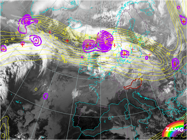

The isotachs in 300 hPa mark the position of the polar front. Wind speeds up to 70 m/s are reached. A strong maximum of PVA is connected with the low pressure system between Great Britain and Scandinavia. Other PVA maxima in the West are connected with the second dominant low pressure system.
Six hours later more E-W-oriented cloudiness can be seen coinciding with the area of high upper wind speeds.
Up to this time step, winds have not accelerated significantly yet. The development of the wave which will play a key role in the forthcoming rapid cyclogenesis will take place in the next hours.
The double structure of the W-E oriented broad cloud area is accompanied by high wind speeds and significant maxima of PVA. They are found mainly in the northern and downstream part of the cloud head leading to higher cloudiness through more intensive convection on its poleward edge.
The jet stream turned into a more NW-SE oriented direction upstream, already coinciding with a dry slot now where stratospheric dry air protrudes downwards into the troposhere. A strong and evident maximum of PVA formed at the left exit region of the jet streak above the cloud head.
The jet streak fits rather well with the northern edge of cirrus clouds. The surface wave is superimposed by PVA.
Strong jet streaks with two branches can be seen in the isotachs, one on the poleward side of the cloud head and the second associated with the dry intrusion. Wind speed increases up to 70 m/s. The left exit region of the jet streak upstream is situated over the North Sea with a broad maximum of PVA extending to central France.
The isotachs at 300 hPa show a pronounced jet stream along the rear edge of the frontal cloud band. Wind speeds of 75 m/s are shown by the model. A strong maximum of PVA is situated in left exit region of the jet streak over the cloud head. The second jet streak still is situated at the polar side of the cloud head.
The location of the split front is found in the left exit region of the jet streak in a diffluent upper trough. This is the area where cyclogenesis occurs.
The jet streak intensifies up to 80 m/s. Two branches of jet streaks can still be distinguished. Two broad areas of PVA can be found in the left exit region and the right entrance region of these two jet streaks. The jet streak plays a dominant role in the development of the cyclogenesis. The position of the cold front is shifting into NW-SE direction with the jet stream.
Wind speed seems to decrease a bit. The NW Jet is getting less important for the development of the rapid cyclogenesis. This branch of the jet has more influence on the second development south of the Alps now.
One maximum of PVA can be found over Poland mainly due to curvature vorticity. A second PVA maximum over the Alps is mainly caused by wind shear in the left exit region of the NW jet streak.
The jet streak weakens further, showing wind speeds up to 65 m/s at this point in time. The left exit region is found over Hungary, Romania and Belarus, superimposing the surface low. The cold front over Hungary is forming a bulge on its backside which coincides well with a strong maximum of PVA in the left exit region. Obviously, front intensifiaction by jet occurs in this area.
The jet streak weakens down to wind speeds of about 60 m/s. The front intensification by jet seems to take place in the left exit region over Romania now, which corresponds with a PVA maximum. A second maximum can be found to the North in the area of the cyclonically curved cloud head.