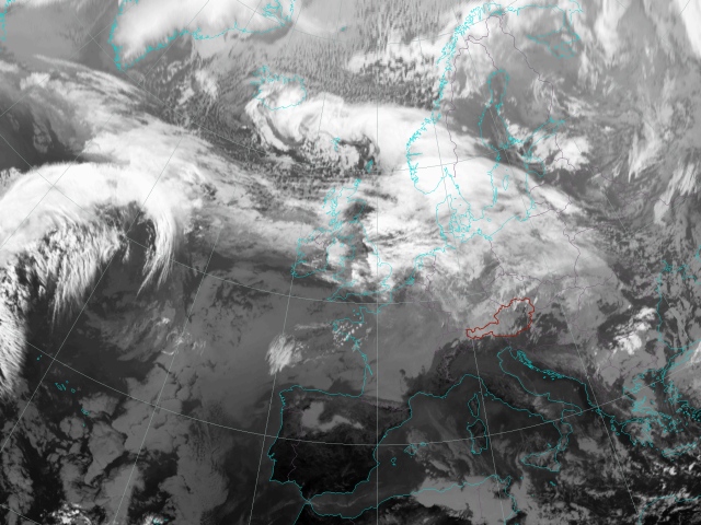

The relevant development in this case study has its origin in the South of Greenland. Main features in the first IR image are two low pressure systems. One can be found to the north of Great Britain and is characterized by pronounced cloudiness on both fronts. The second system is situated in the South of Greenland.
On its back side the cyclone over northern Europe advects cold air from northern areas to the South while the system south of Greenland intensively advects warm air on its foreside to the North. This is the basic constellation of the upcoming development, which is strongly associated with the increasing temperature contrast and upper air processes.
The two low pressure systems move eastwards. Jet stream cloudiness can be noticed in the IR image south of Greenland and Iceland consisting of narrow bright cloud fibres. These fibres denote the location of the upper part of the polar front. It separates unstable stratified polar air from very warm tropical air which is still strongly advected to northern latitudes. At this time step no exchange of air masses occurs yet.
The relevant area of cloudiness for this case study south of Greenland moves eastwards following the jet stream. An occlusion spiral of the low pressure system indicating its mature stage over Europe can be clearly observed to the north of Great Britain.
In this timestep the formation of a wave begins. The IR image shows a double structure of cloudiness characterized by lower cloud tops to the North superimposed by higher cloudiness in the South. The fibrous edges on the northern edge of the higher cloudiness indicate the position of the jet stream. Beginning in this time step, a baroclinic situation develops.
The small wave is moving eastwards and will advance in the next hours. It was formed as a consequence of the frontogenetic situation over the Atlantic south of Iceland. Forced by a strong stream in the upper atmosphere the wave structure is transported to the East and will reach Ireland approximately 12 hours later. This situation marks the origin of the forthcoming development of a rapid cyclogenesis. Surface charts are already showing the wave.
The wave is moving eastwards connected with a strong jet stream. It is now clearly revealed by the frontal cloudiness as a baroclinc leaf. North of this high-reaching cloud field, a typical low-level cloud head develops.
The wave keeps following the upper air stream. A cloud bulge of the higher cloudiness in the South is formed. Baroclinic leaf and cloud head are clearly seen. This cloud configuration is typical for a rapid cyclogenesis process.
The wave structure reaches Ireland. This situation represents the Initial Stage of the rapid cyclogenesis according to the conceptual model. This stage is characterized by a W-E oriented cold front band, which is revealed by the IR images as a baroclinic leaf and a cloud head on its poleward side. The IR image clearly shows a double structure of cloudiness. Warmer cloud tops to the North can be seen, forming an increasingly dense shield with fibrous edges. Brighter colours in the area of the frontal band indicate higher cloud tops. The cloud head varies between grey and light grey, showing brighter values on its northern side, indicating higher cloudiness. The jet should be localized between the cloud head and the frontal cloud band.
Upstream the jet turns into a more NW pronounced direction now. Downstream cloud dissolution indicated by darker areas in the IR image begins, which hints at the advection of dry sinking air originating from lower levels of the stratosphere. This dry intrusion is typically situated on the cyclonic side of the jet stream. It plays a key role in the forthcoming distinct development and will be further documented in the chapter dealing with WV imagery.
The influence of dry upper air can be seen more clearly now. It leads to cloud dissolution between the cloud band of the cold front and the cloud head. The process of downward-protruding high stratospheric air plays an important role in the transition of the wave into a low pressure system.
Over northern Germany a delayed cold front of the old low pressure system in the east merges with the warm front of the wave. The cyclone south of Greenland still permanently advects warm air masses to northern latitudes.
At this time step the dissolution of cloudiness and the cloud head can be seen even more clearly than three hours before. Small fibres associated with the jet stream reach from Greenland over Ireland to northern France.
From the North unstable stratified cold air is advected to the South.
The area of dissolving clouds is growing and can be recognized from southern Great Britain to northern France. The jet stream cirrus cloudiness is still very distinct forming a long narrow NW-SE oriented cloud fibre.
The surface chart at this timestep shows that the surface wave reached central Europe where it starts its transformation into a rapidly deeping cyclone. The cloud head and a broad area of cloud dissolution can be seen as well as a warm conveyor belt ascending from SW. The cloud head seems more cyclonically curved now.
A typical front splitting developed in the past six hours and is clearly shown in IR imagery by different brightness. It indicates overshooting of the sinking dry upper air over the surface front leading to frequent dissolution of cloudiness.
The dimension of this overshooting and the distance between the surface front over the Netherlands/Northern Germany and the upper-level frontal cloudiness over southern Germany are remarkable.
A narrow dark area indicating intruding dry air behind the surface cold front reaching into the cloud head can be seen now. This dry intrusion and the front splitting are consequences of the strongly developed winds in high tropospheric levels. A sharp transition from enhanced cumuli and stratiform clouds over the North Sea still demonstrate the extreme temperature contrast.
Due to strong upper winds and an upper air trough caused by cold advection, the wave is deepening and crosses all of Germany in relative short time.
The cold front near the surface is more distinct at this time and the dry slot reaches far into the cloud head. The wave is rapidly deepening and currently situated over southern Poland. A small band of heavy precipitation over Germany is associated with the cold front. This was also documented by radar observations where short and intense precipitation could be measured (see radar image).
The IR image shows this cloud band in greyish shades, indicating low cloud tops. Crucial for the precipitation seems to be vertical motion by strong convergenve near the surface (see chapter: Vertical Cross Sections). Unusal seems the wide overshooting of the dry upper air which leads far to the Southeast over the Alps. This hints at a decoupled second process which takes place south of the Alps. Note that the relevant development for the Tatra storm takes place north of the Alps.
The cold front at the surface is very distinct now. This cold front brought short but intensive precipitation to southern Germany in the last hours. This intensified cloudiness is also connected with the Alps as an orographic boundary strengthening convective processes. The dry tongue can be seen clearly to the north of the cold front. It reaches far into the more and more cyclonically curved cloud head. The minimum of surface pressure can be found north-east of this intrusion of sinking upper dry air.
Over the last 12 hours the wave structure has transformed into a low pressure system with rapidly falling surface pressure. It reaches the High Tatra Mountains at this time step with a surface pressure of about 985 hPa. The development and the deepening of the cyclone was extremely fast. The developed storm cyclone is well-distributed in IR imagery with a dark centre of upper dry air.
A high surface pressure gradient over parts of eastern Germany, Chech Rep and Slovakia leads to high wind speeds.
The large area of cold air behind the cold front is characterized by enhanced cumuli and cellular cloudiness over central Germany and the North Sea.
The storm over the High Tatras reaches its maximum. Between 15 UTC and 18 UTC there are strong winds from northern directions. Gusts of about 100 kn occur, leading to devastation of forests mainly on the lee side of the High Tatra Mountains.
The cyclonically curved cloud head can be identified in the IR image.
The cold front passed over the Alps and is situated over Italy now where it shows less cloudiness at this time step.
Strong gusts are still observed in the High Tatra but will lose their intensity soon. The low pressure system turns into a more southerly pronounced direction and will grow into a huge cloud spiral over Russia.
Over Hungary the cold front shows a bulge on its western side which could be related with a front intensification by jet. This will be further investigated taking winds into account at 300 hPa (see chapter: Isotachs).
Compared to the situation three hours before lee cloudiness connected to the Alps and the Apennines can be observed now.
The cyclone can be followed taking its way to the North while forming a huge cloud spiral over Russia in the next days.
In the next hours it brings masses of snow to these areas. The surface chart shows the center of the low and the position of the cold front. Between Italy and Croatia a formation of a second wave has started.