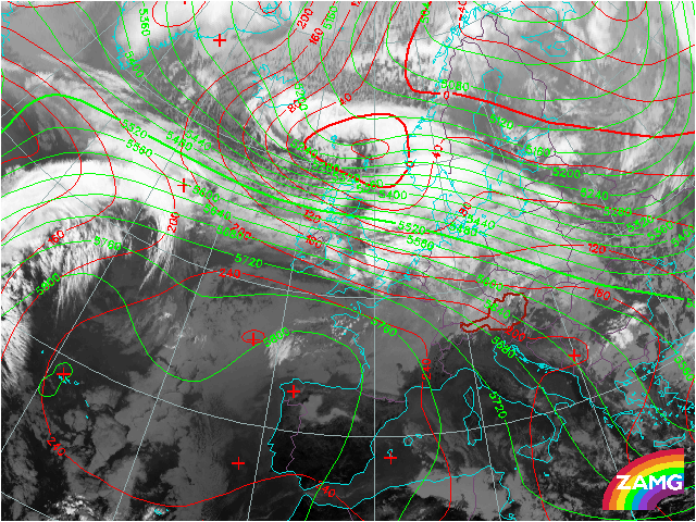

The large low pressure system over northern Europe is represented well by the isobars at 1000 hPa. Its surface low is accompanied by a weak upper air trough. To the South, coinciding with the East-West oriented broad cloud band the 500 hPa lines are crowded. This is the region of the forming wave which leads to the rapid cyclogenesis. A strong gradient of the 500 hPa lines indicates high wind speeds at upper levels.
Higher cloudiness in the zone of the polar front is evident. At the back side of the low pressure system over Scandinavia cold air is intensively advected towards the frontal zone. At this time step no significant upper air trough in the West can be recognized yet. However, the upper air trough at the back side of the surface low over Scandinavia strengthens a bit.
High wind speeds at higher levels of the atmosphere lead to rapid transport of the high-reaching clouds over the Atlantic towards Europe.
The strong surface low over Scandinavia is still intensifying with 980 hPa measured in its centre.
The surface low over Scandinavia intensifies down to 975 hPa.
A broad upper air trough develops coinciding with the wave formation which is also well represented by the clouds in the IR image. In the forefield of the forming upper air trough a surface wave can already be found over Great Britain. A surface pressure of about 1010 hPa over Ireland was measured at this time. The surface pressure of the wave will decrease rapidly in the next 24 hours. A strong temperature contrast exists, documented by enhanced cumulus and compact and high extending stratiform clouds in the IR image.
The surface wave is situated in the forefield of the broad upper air trough. During the last 6 hours an intensification of about 5 hPa can be observed.
Warm conveyor belt, cloud head and dry slot can be seen in IR imagery. The dry slot shows intensification approaching the surface wave. During the last six hours air pressure falls about 5 to 10 hPa. The surface wave is situated in the forefield of the broad upper air trough which is also more pronounced now. The extreme temperature contrast is expressed by a sharp transition from enhanced cumulus over the North Sea to stratiform clouds of the cloud head.
Cyclogenesis is under way and the cloud head is cyclonically curved. The Cold Front is situated over Germany and a broad warm sector is accompanied by intensive weather. The surface low deepened down to 990 hPa signalizing an intensification of about 5 to 10 hPa in the past six hours. The surface low can be found over Poland and is situated in the forefield of the sharpening upper air trough. Enhanced cumuli reached Northern Germany. A high surface pressure gradient exists over parts of western and central Europe.
The model fields are now showing closed surface isobars. The rapidly deepening surface low centre is at the inside edge of the cloud head close to the dry intrusion. The weak upper level trough is situated behind the cloud head. At this time heavy northerly winds are causing massive damage in the High Tatra Mountains of Slovakia. According to the conceptual model of a rapid cyclogenesis gusts of about 100 kn could be observed near the tip of the cloud head west of the surface low centre. The pressure of the surface low is about 985 hPa. This means an intensification of about 25 hpa within the last 24 hours. The preconditions of a rapid cyclogenesis are fulfilled.
In the last six hours heavy storms with gusts up to 100 kn devasted large forest areas in the High Tatra Mountains. The surface low moved eastwards still bringing strong winds from northern direction on its backside. The low itself does not significantly deepen anymore. However, the upper air trough continues sharpening. It contains cold air up to very high levels.
During the last six hours no significant intensification can be noticed anymore. The surface low is still situated in the forefield of the upper air trough that continued shortening the wave length and keeps strenghtening. The dry slot can still be seen west of the surface low. A high surface pressure gradient exists over western Russia. During the next days the low pressure system will take its way to the North where it will form a huge cloud spiral bringing masses of snow.